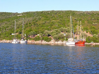
Alonnisos
From CruisersWiki
Istioploos (Talk | contribs) m (Reverted edits by Riley Huntley (talk) to last revision by Istioploos) |
Istioploos (Talk | contribs) (Headings) |
||
| Line 8: | Line 8: | ||
|- | |- | ||
! <center>[[image:Photo_icon.png]]</center> | ! <center>[[image:Photo_icon.png]]</center> | ||
| - | | | + | | [http://www.panoramio.com/map/#lt=39.196875&ln=23.914490&z=5&k=0&a=1&tab=2 Photo gallery] |
|- | |- | ||
! <center>[[image:Chart_icon.png]]</center> | ! <center>[[image:Chart_icon.png]]</center> | ||
| [http://mapserver.mytopo.com/homepage/index.cfm?lat=39.191443307458584&lon=23.918083832078494&scale=300000&zoom=50&type=0&icon=0&searchscope=dom&CFID=17583484&CFTOKEN=79232580&scriptfile=http://mapserver.mytopo.com/homepage/index.cfm&latlontype=DMS Local chartlet] | | [http://mapserver.mytopo.com/homepage/index.cfm?lat=39.191443307458584&lon=23.918083832078494&scale=300000&zoom=50&type=0&icon=0&searchscope=dom&CFID=17583484&CFTOKEN=79232580&scriptfile=http://mapserver.mytopo.com/homepage/index.cfm&latlontype=DMS Local chartlet] | ||
| - | |}{{TOCleft}} | + | |- |
| - | + | | colspan="2" style="text-align:center; font-size: smaller;" | [[Image:Greece_Alonnisos_m.jpg|350px]]Map of Alonnisos & Peristera - ''Click for larger view'' | |
| - | [http://en.wikipedia.org/wiki/Alonissos Alonnisos] (Αλόννησος) or Khelidromi is part of the [http://en.wikipedia.org/wiki/Sporades Sporades] it has about 1,100 inhabitants and an area of 62 km<sup>2</sup>, and its tallest peak, Kavouli, is 470 m. It is a green island with many olive trees, fig trees, almond trees, etc. In the antiquity, 5th century BC, Alonnisos was occupied by the [http://en.wikipedia.org/wiki/Classical_Athens Athenians] under [http://en.wikipedia.org/wiki/Kimon Kimon] and then, on the 3rd century, by [http://en.wikipedia.org/wiki/Philip_II_of_Macedon Philip of Macedonia]. It was later a place used by pirates. The ruins of the ancient city of Iko (Ικώ) have been excavated near Kokino Kastro (Κόκκινο Κάστρο) where some walls and some inscriptions have been found. Also on the little island of Vrachos (Βράχος) were found some [http://en.wikipedia.org/wiki/Paleolithic Paleolithic] tools. | + | |}{{TOCleft}}[http://en.wikipedia.org/wiki/Alonissos Alonnisos] (Αλόννησος) or Khelidromi is part of the [http://en.wikipedia.org/wiki/Sporades Sporades] it has about 1,100 inhabitants and an area of 62 km<sup>2</sup>, and its tallest peak, Kavouli, is 470 m. It is a green island with many olive trees, fig trees, almond trees, etc. In the antiquity, 5th century BC, Alonnisos was occupied by the [http://en.wikipedia.org/wiki/Classical_Athens Athenians] under [http://en.wikipedia.org/wiki/Kimon Kimon] and then, on the 3rd century, by [http://en.wikipedia.org/wiki/Philip_II_of_Macedon Philip of Macedonia]. It was later a place used by pirates. The ruins of the ancient city of Iko (Ικώ) have been excavated near Kokino Kastro (Κόκκινο Κάστρο) where some walls and some inscriptions have been found. Also on the little island of Vrachos (Βράχος) were found some [http://en.wikipedia.org/wiki/Paleolithic Paleolithic] tools. |
The main town in Alonnisos used to be Chora or Alonnisos until 1965 when it was destroyed by an earthquake. | The main town in Alonnisos used to be Chora or Alonnisos until 1965 when it was destroyed by an earthquake. | ||
| + | |||
==Charts== | ==Charts== | ||
| - | + | ; BA | |
| - | + | : 1062 Nísoi Voríoi Sporádhes | |
| - | ;BA | + | ; Imray-Tetra |
| - | :1062 Nísoi Voríoi Sporádhes | + | : G25 Eastern Sporades and North Evvoia |
| - | ;Imray-Tetra | + | ; Greek |
| - | :G25 Eastern Sporades and North Evvoia | + | : 31 North Evoikos to Kavala Gulf |
| - | ;Greek | + | : Greek 74 Corinth to Skopelos Island |
| - | :31 North Evoikos to Kavala Gulf | + | : Greek 331 Sporades to Ay. Efstratios |
| - | :Greek 74 Corinth to Skopelos Island | + | |
| - | :Greek 331 Sporades to Ay. Efstratios | + | |
==Radio Nets== | ==Radio Nets== | ||
| - | |||
| - | |||
* Coast Guard - VHF channel 12 and tel. Tel. +30 4240 65 595 (Patitiri) | * Coast Guard - VHF channel 12 and tel. Tel. +30 4240 65 595 (Patitiri) | ||
* Olympia Radio - VHF no signal | * Olympia Radio - VHF no signal | ||
| + | |||
| + | ''Also see [[World MM Nets|World Cruiser's Nets]]''. | ||
| + | |||
==Weather== | ==Weather== | ||
''See [[Aegean_Sea#Weather_and_Winds|Aegean Sea]]''. | ''See [[Aegean_Sea#Weather_and_Winds|Aegean Sea]]''. | ||
| Line 40: | Line 40: | ||
In general, during the summer months the ''meltemi'' is weaker in the Sporades region. Approaches to the island are straight forward, no dangers. | In general, during the summer months the ''meltemi'' is weaker in the Sporades region. Approaches to the island are straight forward, no dangers. | ||
Specific dangers are mentioned, as needed, for each port or anchorage. | Specific dangers are mentioned, as needed, for each port or anchorage. | ||
| - | |||
| - | |||
| - | |||
<div style="clear: both;"></div> | <div style="clear: both;"></div> | ||
| - | == | + | |
| + | ==Berthing Options== | ||
===Ports=== | ===Ports=== | ||
The main harbor in Alonnisos is Patitiri but, near by [[#Votsi|Votsi]], is a more attractive anchorage. So is [[#Steni_Vala|Steni Vala]] and [[#Kokino_Kastro|Kokino Kastro]]. | The main harbor in Alonnisos is Patitiri but, near by [[#Votsi|Votsi]], is a more attractive anchorage. So is [[#Steni_Vala|Steni Vala]] and [[#Kokino_Kastro|Kokino Kastro]]. | ||
====Patitiri==== | ====Patitiri==== | ||
| - | [[ | + | {| class="infobox bordered" style="width: 28em; text-align: left; font-size: 90%;" |
| - | [[ | + | |- |
| + | | colspan="2" style="text-align:center; font-size: smaller;" | {{Small info}} (''Click links for more information'') | ||
| + | |- | ||
| + | ! <center>[[image:World_icon.png]]</center> | ||
| + | | {{Coord|39|08.52|N|23|52.03|E|}} | ||
| + | |- | ||
| + | ! <center>[[image:Photo_icon.png]]</center> | ||
| + | | [http://www.panoramio.com/map/#lt=39.142982&ln=23.865858&z=1&k=0&a=1&tab=2&pl=all Photo gallery] | ||
| + | |- | ||
| + | ! <center>[[image:Chart_icon.png]]</center> | ||
| + | | [http://mapserver.maptech.com/homepage/index.cfm?lat=39.142&lon=23.867167&scale=24000&zoom=50&type=1 Local chartlet] | ||
| + | |- | ||
| + | | colspan="2" style="text-align:center; font-size: smaller;" | [[Image:Greece_Patitiri_h.jpg|350px]]Chart of Patitiri - ''Click for larger view'' | ||
| + | |- | ||
| + | | colspan="2" style="text-align:center; font-size: smaller;" | [[Image:Greece_Patitiri1.jpg|350px]]The Harbor of Patitiri | ||
| + | |} | ||
[http://en.wikipedia.org/wiki/Patitiri Patitiri] (Πατητήρι) is the harbor and the largest town in Alonnisos. The harbor affords good shelter from the meltemi. You can anchor moor stern-to at the quay to the north of the ferry dock, though space here is limited, or anchor moor on the south side of the ferry quay itself. The bottom is mostly sand and provides good holding. The quay is liable to be crowded during the summer months, while the SW of the harbor is more exposed to westerlies and is crowded with permanent moorings. | [http://en.wikipedia.org/wiki/Patitiri Patitiri] (Πατητήρι) is the harbor and the largest town in Alonnisos. The harbor affords good shelter from the meltemi. You can anchor moor stern-to at the quay to the north of the ferry dock, though space here is limited, or anchor moor on the south side of the ferry quay itself. The bottom is mostly sand and provides good holding. The quay is liable to be crowded during the summer months, while the SW of the harbor is more exposed to westerlies and is crowded with permanent moorings. | ||
The town is attractive and has good shopping but it is relatively new and its architecture is nothing special. The society for the preservation of the [http://en.wikipedia.org/wiki/Mediterranean_Monk_Seal Mediterranean Seal], ''Monachus Monachus'' or as it is locally known,[http://www.mofi.gr/uk/index.htm ''MOm''] have an information pavilion in Patitiri which is also the headquarters for their patrol boats. | The town is attractive and has good shopping but it is relatively new and its architecture is nothing special. The society for the preservation of the [http://en.wikipedia.org/wiki/Mediterranean_Monk_Seal Mediterranean Seal], ''Monachus Monachus'' or as it is locally known,[http://www.mofi.gr/uk/index.htm ''MOm''] have an information pavilion in Patitiri which is also the headquarters for their patrol boats. | ||
| - | + | <div style="clear: right;"></div> | |
| - | <div style="clear: | + | |
| - | + | ||
====Votsi==== | ====Votsi==== | ||
| - | [[ | + | {| class="infobox bordered" style="width: 28em; text-align: left; font-size: 90%;" |
| - | [[ | + | |- |
| + | | colspan="2" style="text-align:center; font-size: smaller;" | {{Small info}} (''Click links for more information'') | ||
| + | |- | ||
| + | ! <center>[[image:World_icon.png]]</center> | ||
| + | | {{Coord|39|08.9|N|23|52.4|E|}} | ||
| + | |- | ||
| + | ! <center>[[image:Photo_icon.png]]</center> | ||
| + | | [http://www.panoramio.com/map/#lt=39.148716&ln=23.874814&z=1&k=0&a=1&tab=2&pl=allPhoto gallery] | ||
| + | |- | ||
| + | ! <center>[[image:Chart_icon.png]]</center> | ||
| + | | [[http://mapserver.maptech.com/homepage/index.cfm?lat=39.148333&lon=23.873333&scale=24000&zoom=50&type=1 Local chartlet] | ||
| + | |- | ||
| + | | colspan="2" style="text-align:center; font-size: smaller;" | [[Image:Greece_Votsi_h.jpg|350px]]Chart of Votsi | ||
| + | |- | ||
| + | | colspan="2" style="text-align:center; font-size: smaller;" | [[Image:Greece_Votsi.jpg|350px]]The Anchorage of Votsi - ''Click for larger view'' | ||
| + | |} | ||
Votsi (Βότση) is one cove north of Patitiri. It is my favorite anchorage in Alonnisos in that it is fairly easy to anchor, very well protected from both the ''meltemi'' and the south-west winds, it is very quiet, and only about 40 minutes on foot to Patitiri. | Votsi (Βότση) is one cove north of Patitiri. It is my favorite anchorage in Alonnisos in that it is fairly easy to anchor, very well protected from both the ''meltemi'' and the south-west winds, it is very quiet, and only about 40 minutes on foot to Patitiri. | ||
| Line 67: | Line 93: | ||
In August of 2011 there were so many boats, many on permanent moorings, that it was extremely difficult to find space. --[[User:Istioploos|Istioploos]] | In August of 2011 there were so many boats, many on permanent moorings, that it was extremely difficult to find space. --[[User:Istioploos|Istioploos]] | ||
| - | + | ===Marinas & Yacht Clubs=== | |
| - | + | None. | |
| - | + | ||
===Anchorages=== | ===Anchorages=== | ||
| Line 93: | Line 118: | ||
[[image:World_icon.png]] {{Coord|39|08.5|N|23|50.3|E|}}<br /> | [[image:World_icon.png]] {{Coord|39|08.5|N|23|50.3|E|}}<br /> | ||
This is a bay on the south-west side of the island. It is very exposed to the south but offers some protection to the north winds. Not a very safe anchorage. | This is a bay on the south-west side of the island. It is very exposed to the south but offers some protection to the north winds. Not a very safe anchorage. | ||
| + | <div style="clear: right;"></div> | ||
| - | == | + | ==Offshore Islands== |
| - | + | ====Peristera==== | |
| + | [[Image:Greece_Peristera.jpg|345px|thumb|right|The Anchorage at Vasiliko, Peristerai<br />''Click for larger view'']] | ||
| + | |||
| + | The island of Peristera (Περιστέρα) or Peristeri or Xero is very lightly inhabited island just east of Alonnisos. There are three anchorages on the island and no facilities. | ||
| + | # Vasiliko - Vasiliko (Βασιλικό) [[image:World_icon.png]] {{Coord|39|12|N|23|58.6|E|}} is a bay at the middle of the west side of the Peristera. The northern corner of the bay is well protected from the ''meltemi'' but is exposed to the south winds. The south corner offers some protection but you have to anchor at 15-20 m depth on weed. Bad holding. | ||
| + | # Vourlia - This cove [[image:World_icon.png]] {{Coord|39|11.2|N|23|56.7|E|}}, just south-west of Vasiliko, provides much better shelter from the south winds than Vasiliko. Anchor near the N coast and take a shore line to a rock on the south coast. Good holding on a mostly sand bottom. Here you will be totally isolated save for a large flock of seagulls that roost here. | ||
| + | # Peristera or Xero Bay - An isolated bay [[image:World_icon.png]] {{Coord|39|10.2|N|23|58.2|E|}} at the south of the island. Well protected from the ''meltemi'' but open to the south. This is maybe the most attractive anchorage in the region. | ||
==Yacht Services and Repairs== | ==Yacht Services and Repairs== | ||
| Line 112: | Line 144: | ||
: N/A | : N/A | ||
| - | == | + | ==Things to do Ashore== |
| - | + | ====Tourism==== | |
| - | + | ||
| - | + | ||
| - | + | ||
| - | + | ||
| - | + | ||
| - | + | ||
| - | + | ||
| - | ===Tourism=== | + | |
The restored town of Chora is well worth a visit. It is about 5 km from either Patitiri or Votsi. | The restored town of Chora is well worth a visit. It is about 5 km from either Patitiri or Votsi. | ||
The town was destroyed in 1965 by an earthquake. At that time Greece was under a [http://en.wikipedia.org/wiki/Greek_military_junta_of_1967–1974 military junta]. They ordered the town to be evacuated and set temporary housing for the inhabitants at [[#Patitiri|Patitiri]]. The inhabitants were prevented from going back and rebuilding but were ordered to stay in Patitiri. Chora remained in ruins for several years. Some enterprising Germans bought a few ruined houses, for a very low price, and restored them. Their example was followed by more Germans and a few Englishmen. This process was just beginning in 1986. Now, more then half of the houses have been restored, most of them very tastefully. There is, alas, an overabundance of restaurants and bars. There are also a few art galleries but today they were all closed. Several of the streets have been re-paved with flagstones. By in large, the restoration of Chora is an example worthy of imitation. | The town was destroyed in 1965 by an earthquake. At that time Greece was under a [http://en.wikipedia.org/wiki/Greek_military_junta_of_1967–1974 military junta]. They ordered the town to be evacuated and set temporary housing for the inhabitants at [[#Patitiri|Patitiri]]. The inhabitants were prevented from going back and rebuilding but were ordered to stay in Patitiri. Chora remained in ruins for several years. Some enterprising Germans bought a few ruined houses, for a very low price, and restored them. Their example was followed by more Germans and a few Englishmen. This process was just beginning in 1986. Now, more then half of the houses have been restored, most of them very tastefully. There is, alas, an overabundance of restaurants and bars. There are also a few art galleries but today they were all closed. Several of the streets have been re-paved with flagstones. By in large, the restoration of Chora is an example worthy of imitation. | ||
| - | ===Grocery & Supply Stores=== | + | ====Grocery & Supply Stores==== |
There are several grocery stores in [[#Patitiri|Patitiri]] | There are several grocery stores in [[#Patitiri|Patitiri]] | ||
| - | ===Eateries=== | + | ====Eateries==== |
* Good and moderately priced food at the ''Kamaki'' restaurant just off the waterfront on the road towards [[#Votsi|Votsi]] | * Good and moderately priced food at the ''Kamaki'' restaurant just off the waterfront on the road towards [[#Votsi|Votsi]] | ||
* Rather indifferent food in the waterfront restaurants in [[#Patitiri|Patitiri]] | * Rather indifferent food in the waterfront restaurants in [[#Patitiri|Patitiri]] | ||
* Pleasant tavernas and cafés in Chora | * Pleasant tavernas and cafés in Chora | ||
| - | ===Internet/ | + | ====Internet/WiF=i=== |
In cafés. | In cafés. | ||
| - | ===Laundry=== | + | ====Laundry==== |
There is a laundry in [[#Patitiri|Patitiri]]. | There is a laundry in [[#Patitiri|Patitiri]]. | ||
| - | ===Motorbike & Car Rentals=== | + | ====Motorbike & Car Rentals==== |
There is motorbike rental place up the hill from [[#Patitiri|Patitiri]] on the road to Chora. | There is motorbike rental place up the hill from [[#Patitiri|Patitiri]] on the road to Chora. | ||
| - | ===Garbage Disposal=== | + | ====Garbage Disposal==== |
There are bins around the harbors and in several anchorages. | There are bins around the harbors and in several anchorages. | ||
| - | ===Transportation=== | + | ====Transportation==== |
Frequent hydrofoil service to the other Sporades and the mainland. | Frequent hydrofoil service to the other Sporades and the mainland. | ||
| Line 157: | Line 181: | ||
==Forum Discussions== | ==Forum Discussions== | ||
| - | List links to discussion threads on [[Cruising Forums|partnering forums]]. (see link for requirements) | + | List links to discussion threads on [[Cruising Forums|partnering forums]]. (''see link for requirements'') |
| - | + | ||
* | * | ||
* | * | ||
| Line 171: | Line 194: | ||
| - | |||
| - | |||
| - | |||
| - | |||
==Personal Notes== | ==Personal Notes== | ||
Personal experiences? | Personal experiences? | ||
* | * | ||
| + | |||
| + | ====Last Visited & Details Checked (and updated here)==== | ||
| + | ''Date of member's visit to this Port/Stop & this page's details validated'': | ||
| + | * June 2006 --[[User:Atheneoflymington|Athene of Lymington]] | ||
| + | * August 2011 --[[User:Istioploos|Istioploos]] [[Image:Greece_Icon.png]] | ||
| Line 200: | Line 224: | ||
|} | |} | ||
| - | |||
| - | |||
[[Category:Islands - Greece]] [[Category:Ports - Greece]] [[Category:Anchorages - Greece]] | [[Category:Islands - Greece]] [[Category:Ports - Greece]] [[Category:Anchorages - Greece]] | ||
Revision as of 22:06, 1 March 2013
Alonisos
| | |
| | 39°08.52′N, 23°52.03′E |
|---|---|
| | Photo gallery |
| | Local chartlet |
| 350pxMap of Alonnisos & Peristera - Click for larger view | |
The main town in Alonnisos used to be Chora or Alonnisos until 1965 when it was destroyed by an earthquake.
Charts
- BA
- 1062 Nísoi Voríoi Sporádhes
- Imray-Tetra
- G25 Eastern Sporades and North Evvoia
- Greek
- 31 North Evoikos to Kavala Gulf
- Greek 74 Corinth to Skopelos Island
- Greek 331 Sporades to Ay. Efstratios
Radio Nets
- Coast Guard - VHF channel 12 and tel. Tel. +30 4240 65 595 (Patitiri)
- Olympia Radio - VHF no signal
Also see World Cruiser's Nets.
Weather
See Aegean Sea.
In general, during the summer months the meltemi is weaker in the Sporades region. Approaches to the island are straight forward, no dangers. Specific dangers are mentioned, as needed, for each port or anchorage.
Berthing Options
Ports
The main harbor in Alonnisos is Patitiri but, near by Votsi, is a more attractive anchorage. So is Steni Vala and Kokino Kastro.
Patitiri
| | |
| | 39°08.52′N, 23°52.03′E |
|---|---|
| | Photo gallery |
| | Local chartlet |
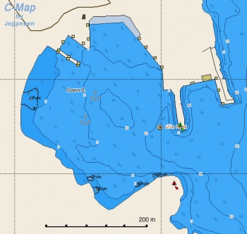 Chart of Patitiri - Click for larger view Chart of Patitiri - Click for larger view
| |
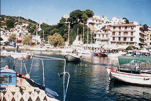 The Harbor of Patitiri The Harbor of Patitiri
| |
Patitiri (Πατητήρι) is the harbor and the largest town in Alonnisos. The harbor affords good shelter from the meltemi. You can anchor moor stern-to at the quay to the north of the ferry dock, though space here is limited, or anchor moor on the south side of the ferry quay itself. The bottom is mostly sand and provides good holding. The quay is liable to be crowded during the summer months, while the SW of the harbor is more exposed to westerlies and is crowded with permanent moorings.
The town is attractive and has good shopping but it is relatively new and its architecture is nothing special. The society for the preservation of the Mediterranean Seal, Monachus Monachus or as it is locally known,MOm have an information pavilion in Patitiri which is also the headquarters for their patrol boats.
Votsi
| | |
| | 39°08.9′N, 23°52.4′E |
|---|---|
| | gallery |
| | [Local chartlet |
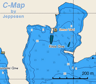 Chart of Votsi Chart of Votsi
| |
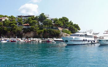 The Anchorage of Votsi - Click for larger view The Anchorage of Votsi - Click for larger view
| |
Votsi (Βότση) is one cove north of Patitiri. It is my favorite anchorage in Alonnisos in that it is fairly easy to anchor, very well protected from both the meltemi and the south-west winds, it is very quiet, and only about 40 minutes on foot to Patitiri.
It is best to anchor just behind the jetty. In the fall, when the wind can change direction it is best to use two anchors: one from the bow and one from the stern. This will keep the boat form swinging in the small cove. Alternatively one can take a long shore line to the trees, W of the jetty. The bottom is mostly sand and provides good holding. There is a small quay, but it usually occupied.
In August of 2011 there were so many boats, many on permanent moorings, that it was extremely difficult to find space. --Istioploos
Marinas & Yacht Clubs
None.
Anchorages
Steni Vala
![]() 39°11.5′N, 23°55.5′E
39°11.5′N, 23°55.5′E
Steni Vala (Στενή Βάλα) is a small harbor, just across from Peristera Island. A flotilla operates from here during the summer months and the quay is crowded. It is an attractive place with a few tavernas. Go stern-to the quay.
MOm has been operating their seal rescue center here but in 1999 they relocated it in Gerakas.
Kokino Kastro
![]() 39°10.1′N, 23°54.1′E
39°10.1′N, 23°54.1′E
Kokino Kastro (Κόκκινο Κάστρο) is located about 2 nM north of Votsi. It takes its name from the red color of the cliffs. There are several very attractive coves with sandy beaches and pine trees all well protected from the meltemi.
The ruins of the ancient city of Iko (Ικώ) have been excavated near by and you can visit them. Also on the little island of Vrachos (Βράχος) were found some Paleolithic tools.
Gerakas
![]() 39°16.3′N, 23°56.9′E
39°16.3′N, 23°56.9′E
Gerakas (Γέρακας) is a narrow bay at the nothern tip of the island. It is very nice but it is exposed to the north-east and not a suitable anchorage during the meltemi season.
The MOm seal rehabilitation center operates here.
Mourtia
![]() 39°08.5′N, 23°50.3′E
39°08.5′N, 23°50.3′E
This is a bay on the south-west side of the island. It is very exposed to the south but offers some protection to the north winds. Not a very safe anchorage.
Offshore Islands
Peristera
The island of Peristera (Περιστέρα) or Peristeri or Xero is very lightly inhabited island just east of Alonnisos. There are three anchorages on the island and no facilities.
- Vasiliko - Vasiliko (Βασιλικό)
 39°12′N, 23°58.6′E is a bay at the middle of the west side of the Peristera. The northern corner of the bay is well protected from the meltemi but is exposed to the south winds. The south corner offers some protection but you have to anchor at 15-20 m depth on weed. Bad holding.
- Vourlia - This cove
 39°11.2′N, 23°56.7′E, just south-west of Vasiliko, provides much better shelter from the south winds than Vasiliko. Anchor near the N coast and take a shore line to a rock on the south coast. Good holding on a mostly sand bottom. Here you will be totally isolated save for a large flock of seagulls that roost here.
- Peristera or Xero Bay - An isolated bay
 39°10.2′N, 23°58.2′E at the south of the island. Well protected from the meltemi but open to the south. This is maybe the most attractive anchorage in the region.
Yacht Services and Repairs
Marine Stores
None.
Yacht Services/Repairs/Yards
None.
Fuel, Water, & Electricity
- Fuel
- About 1 km up the hill from either Patitiri or Votsi. Almost impossible to carry jerry cans without a vehicle
- Water
- N/A (Not Available)
- Electricity
- N/A
Things to do Ashore
Tourism
The restored town of Chora is well worth a visit. It is about 5 km from either Patitiri or Votsi.
The town was destroyed in 1965 by an earthquake. At that time Greece was under a military junta. They ordered the town to be evacuated and set temporary housing for the inhabitants at Patitiri. The inhabitants were prevented from going back and rebuilding but were ordered to stay in Patitiri. Chora remained in ruins for several years. Some enterprising Germans bought a few ruined houses, for a very low price, and restored them. Their example was followed by more Germans and a few Englishmen. This process was just beginning in 1986. Now, more then half of the houses have been restored, most of them very tastefully. There is, alas, an overabundance of restaurants and bars. There are also a few art galleries but today they were all closed. Several of the streets have been re-paved with flagstones. By in large, the restoration of Chora is an example worthy of imitation.
Grocery & Supply Stores
There are several grocery stores in Patitiri
Eateries
- Good and moderately priced food at the Kamaki restaurant just off the waterfront on the road towards Votsi
- Rather indifferent food in the waterfront restaurants in Patitiri
- Pleasant tavernas and cafés in Chora
=Internet/WiF=i
In cafés.
Laundry
There is a laundry in Patitiri.
Motorbike & Car Rentals
There is motorbike rental place up the hill from Patitiri on the road to Chora.
Garbage Disposal
There are bins around the harbors and in several anchorages.
Transportation
Frequent hydrofoil service to the other Sporades and the mainland.
Routes/Passages To/From
Cruiser's Friends
Contact details of "Cruiser's Friends" that can be contacted for local information or assistance.
Forum Discussions
List links to discussion threads on partnering forums. (see link for requirements)
External Links
- Alonnisos (Wikipedia)
References & Publications
See Greece.
Personal Notes
Personal experiences?
Last Visited & Details Checked (and updated here)
Date of member's visit to this Port/Stop & this page's details validated:
- June 2006 --Athene of Lymington
- August 2011 --Istioploos

|
|---|
|
Names: Istioploos, Athene of Lymington, Lighthouse |
| |
|---|
| | HOMEPAGE | Wiki Contents | Mediterranean | Aegean Sea | Greece | Alonisos | |
