Cameroon
From CruisersWiki
| Cameroon
| |
| Capital | Yaoundé |
|---|---|
| Language | French and English |
| Currency | Central African Franc (XAF) |
| Time zone | WAT (UTC+1) |
| Calling code | +237 |
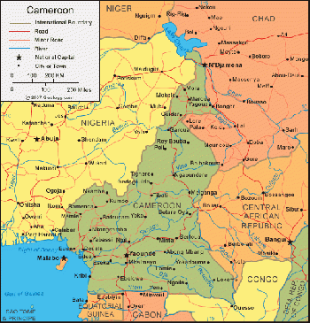
Cameroon (/ˌkæməˈruːn/; French: Cameroun), officially the Republic of Cameroon (French: République du Cameroun), is a country wedged in West and Central Africa. It is bordered by Nigeria to the west and north; Chad to the northeast; the Central African Republic to the east; and Equatorial Guinea, Gabon and the Republic of the Congo to the south. Cameroon's coastline lies on the Bight of Biafra, part of the Gulf of Guinea and the Atlantic Ocean.
The territory of present day Cameroon was first settled during the Neolithic period. Portuguese sailors reached the coast in 1472. Over the following few centuries, European interests regularised trade with the coastal peoples, and Christian missionaries pushed inland. In the early 19th century, Modibo Adama led Fulani soldiers on a jihad in the north against non-Muslim and partially Muslim peoples and established the Adamawa Emirate. Settled peoples who fled the Fulani caused a major redistribution of population.
The German Empire claimed the territory as the colony of Kamerun in 1884 and began a steady push inland. With the defeat of Germany in World War I, Kamerun became a League of Nations mandate territory and was split into French Cameroun and British Cameroons in 1919. The French carefully integrated the economy of Cameroun with that of France and improved the infrastructure with capital investments, skilled workers, and continued forced labor.
The British administered their territory from neighboring Nigeria. Natives complained that this made them a neglected "colony of a colony". The League of Nations mandates were converted into United Nations Trusteeships in 1946, and the question of independence became a pressing issue in French Cameroun. France outlawed the most radical political party, the Union des Populations du Cameroun (UPC), on 13 July 1955. This prompted a long guerrilla war. In British Cameroons, the question was whether to reunify with French Cameroun or join Nigeria.
On 1 January 1960, French Cameroun gained independence from France under President Ahmadou Ahidjo, and on 1 October 1961, the formerly British Northern Cameroons became a part of Nigeria, while the formerly British Southern Cameroons united with its neighbor to form the Federal Republic of Cameroon.
Charts
- British Admiralty
- BA1357 - Bonin river to Riviére Cameroun, including the mouth of the River Niger
- BA160 - Bonny river to Estuaire du Cameroun
Weather
Submit the climate & general weather details here. For very large countries remove this section and cover weather in Region ( Region Template) pages.
Weather links
Sources of weather forecasting here.
Passages
List popular passages/routes, timing, etc.
Islands
- Bioko
Communication
Any navigation notes here. If this section does not apply, remove it.
Also see World Cruiser's Nets.
Any navigation notes here. If this section does not apply, remove it.
Entrance
Arrival
Details?
Departure
Details?
Customs and Immigration
Customs
Details?
Immigration
Details?
Fees and Charges
Restrictions
Health and Security
Health
Submit any health warnings/information. Remove any of these sections do not apply to this particular country.
Security
Details?
Berthing
Ports
Marinas & Yacht Clubs
None
Anchorages
List anchorages except the ones covered under Offshore Islands below. If there is more then 2 paragraphs for a given anchorage, create a dedicated page for it (Port/Stop Template).
Transportation
- International airports are located in Douala and Yaoundé
- Transport in Cameroon is often difficult. Except for the several relatively good toll roads which connect major cities (all of them one-lane) roads are poorly maintained and subject to inclement weather, since only 10% of the roadways are tarred. Roadblocks often serve little other purpose than to allow police and gendarmes to collect bribes from travelers. Road banditry has long hampered transport along the eastern and western borders, and since 2005, the problem has intensified in the east as the Central African Republic has further destabilized.
Friends
Contact details of "Cruiser's Friends" that can be contacted for local information or assistance.
Forums
List links to discussion threads on partnering forums. (see link for requirements)
Links
References
- Steve Jones, Ed Wheeler, and Penny Scott-Bayfield, Cruising Guide To West Africa, Royal Cruising Club Pilotage Foundation (December 2009), ISBN 978-0952777120
Comments
We welcome users' contributions to the Wiki. Please click on Comments to view other users' comments, add your own personal experiences or recommend any changes to this page following your visit.
Verified by
Date of member's last visit to Cameroon and this page's details validated:
If you provide a lot of info and this page is almost complete, change {{Page outline}} to {{Page useable}}.
| This page has an outline in place but needs completing. Please contribute if you can to help it grow further. Click on Comments to suggest further content or alternatively, if you feel confident to edit this page, click on the edit tab at the top and enter your changes directly. |
| |
|---|
|
Names: Lighthouse |

