Capo d'Orlando
From CruisersWiki
| Capo d'Orlando
| |
| | |
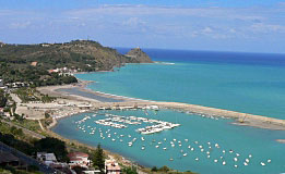
The harbour of Capo d’Orlando lies 10 miles NE of Sant’ Agata in Sicily, immediately E of the eponymous cape. The harbour has silted badly in recent years, especially around the northern breakwater, and great care is needed on entry. Larger yachts are recommended to avoid it altogether. Depths are reported as little as 2.0 metres in the entrance. With any swell, the entrance would probably be dangerous. In strong NE winds, it is very uncomfortable.
UPDATE: The harbour was closed and underwent a major reform into a full-fledged marina. In July 2017, the marina opened. Works are still ongoing, but at present half the pontoons are already usable. Even though building works are still ongoing, mooring fees are considerably higher than the nearby Sant’ Agata.
Charts
- British Admiralty
- 1976 - Capo di Bonifati to Capo San Vito
- Italian
- 916
Weather
Prevailing winds in the Straits during the summer are from N or NW. Southerly winds are more common in the spring and winter. In unsettled weather the Straits can be subject to very strong gusts off the land which, combined with the strong currents, can make passage dangerous for smaller yachts. Currents at Riposto are weaker than in the Straits, although gusts will still be experienced off the high land in NW winds.
Sources for weather forecasts:
- There is a continuous (computerised voice) weather forecast on VHF 68 - first in Italian and then followed with an English translation.
- The same forecast is given in Italian and English on VHF coastal stations following a notification on channel 16
- Navtex weather forecasts are broadcast from stations at Roma, Cagliari (Sardinia) and Augusta (Sicily)
Passages
Popular passages/routes, timing, etc.
Islands
Communication
Also see World Cruiser's Nets.
The lighthouse on Capo d’Orlando one mile W of the harbour is conspicuous. Beware of shallow reefs and offshore rocks around the cape. For entry to Capo d’Orlando harbour, see warning above.
Berthing
Marinas & Yacht Clubs
Capo d’Orlando Marina
Has 553 berths (40 m max, 4.5 m deep) and 48 dry berths. Water, electricity, showers, WiFi, restaurants, dry dock, travel lift.
- [email protected]; Tel: +39 335 6237473; Fax: +39 0941912770; VHF channel XX
- Address: Via Mancini, 33 – 98071 Capo d’Orlando (ME), Italy
- Hours: Office Monday to Saturday 9:00 a.m. to 13:00, & 15:00 to 19:00
Anchorages
None.
Amenities
| Facilities | |
|---|---|
| Water | In the marina |
| Electricity | In the marina |
| Toilets | In the marina |
| Showers | In the marina |
| Laundry | ? |
| Garbage | In the marina |
| Supplies | |
| Fuel | Fuel station on the mole (however, depths probably too shallow for some yachts) |
| Bottled gas | ? |
| Chandlers | ? |
| Services | |
| Repairs | In the marina |
| Internet | WiFii in the marina |
| Mobile connectivity | WiFii in the marina |
| Vehicle rentals | ? |
Provisioning
Nearest shops half hour’s walk away in village.
Eating out
In the marina and within walking distance to W.
Transportation
Small ferries to Aeolian Islands.
Tourism
History
Give a short history of the port.
Places to Visit
List places of interest, tours, etc.
Friends
Contact details of "Cruiser's Friends" that can be contacted for local information or assistance.
Forums
List links to discussion threads on partnering forums. (see link for requirements)
Links
- Capo d'Orlando at the Wikipedia
- Orlando Pagine Azzurre - Capo d'
References
See Italy.
Comments
We welcome users' contributions to the Wiki. Please click on Comments to view other users' comments, add your own personal experiences or recommend any changes to this page following your visit.
Verified by
Date of member's last visit to Capo d'Orlando and this page's details validated:
- Information compiled from web research (please update if possible)--Athene of Lymington 13:52, 17 November 2010 (UTC)
- Added information in Berthing Options & External Links --s/v Seatern 16:25, 11 September 2013 (BST)
| This is a usable page of the cruising guide. However, please contribute if you can to help it grow further. Click on Comments to add your personal notes on this page or to discuss its contents. Alternatively, if you feel confident to edit the page, click on the edit tab at the top and enter your changes directly. |
| |
|---|
|
Names: Lighthouse, Athene of Lymington |
