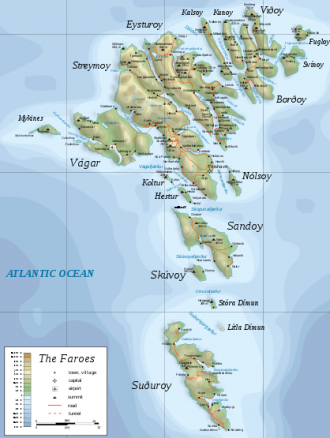
Faroe Islands
From CruisersWiki
Faroe Islands Cruising Guide
An online cruising guide for yachts sailing to the Faroe Islands.
| Faroe Islands | |
 Map - click for larger view | |
 Flag | |
| Capital: | Tórshavn GPS: 62°00.0′N, 06°47.0′W |
|---|---|
| Language: | Faroese, Danish |
| Currency: | Faroese krona |
| Timezone: | UTC |
| More notes about the country | |
| | |
| Content - news items, etc. | |
Overview
The Faroe Islands are a group consisting of eighteen islands off the coast of Northern Europe, between the Norwegian Sea and the north Atlantic Ocean, about halfway between Iceland and Norway; the closest neighbours being the Northern and Western Isles of Scotland.
Its area is 1,399 square kilometres (540 sq. mi), and has no major lakes or rivers. There are 1,117 kilometres (694 mi) of coastline, and no land boundaries with any other country. The only island that is uninhabited is Lítla Dímun.
The islands are rugged and rocky with some low peaks; the coasts are mostly bordered by cliffs. The highest point is Slættaratindur, 882 metres (2,894 ft) above sea level. There are areas below sea level.
Cruising the region
Filler text, please replace.
"Sed ut perspiciatis unde omnis iste natus error sit voluptatem accusantium doloremque laudantium, totam rem aperiam, eaque ipsa quae ab illo inventore veritatis et quasi architecto beatae vitae dicta sunt explicabo. Nemo enim ipsam voluptatem quia voluptas sit aspernatur aut odit aut fugit, sed quia consequuntur magni dolores eos qui ratione voluptatem sequi nesciunt. Neque porro quisquam est, qui dolorem ipsum quia dolor sit amet, consectetur, adipisci velit, sed quia non numquam eius modi tempora incidunt ut labore et dolore magnam aliquam quaerat voluptatem. Ut enim ad minima veniam, quis nostrum exercitationem ullam corporis suscipit laboriosam, nisi ut aliquid ex ea commodi consequatur? Quis autem vel eum iure reprehenderit qui in ea voluptate velit esse quam nihil molestiae consequatur, vel illum qui dolorem eum fugiat quo voluptas nulla pariatur?"
Climate & Weather
The climate is technically defined as Maritime Subarctic according to the (Köppen climate classification:Cfc). The overall character of the islands' climate is determined by the strong cooling influence of the Atlantic Ocean, which here produces the North Atlantic Current. This, together with the remoteness of any sources of warm airflows ensures that winters are mild (mean temperature 3.0 to 4.0°C) while summers are cool (mean temperature 9.5 to 10.5°C). The islands are windy, cloudy and cool throughout the year with over 260 rainy days in the year. The islands lie in the path of depressions moving northeast and this means that strong winds and heavy rain are possible at all times of the year. Sunny days are rare and overcast days are common
Sources of weather forecasting here.
Charts
- NGA
- 38030 Faroe Islands, Iceland
- KMS
- 82 Føroyar, Norđari partur
- 83 Føroyar, Sunnari partur
Any navigation notes here.
Local Radio Nets
Also see Cruiser's Nets
Arrival/Departure procedures
Arrival
Details?
Departure
Details?
Immigration
Details?
Customs
Details?
Islands, Ports & Popular Stops
- Bordoy
- Klaksvik (Port of entry)
- Eysturoy
- Eidi
- Fuglafjordur (Port of entry)
- Sandoy
- Streymoy
- Torshavn (Port of entry)
- Vestmanna/Vestmanhavn (Port of entry)
- Suduroy
- Hvalbiarfjordur
- Tvoroyri (Port of entry)
- Vagur (Suduroy) (Port of entry)
- Vagar Island
-
Health
Submit any health warnings/information.
Security
Details?
Transportation
Transportation - mainland or to other countries, etc.
Cruiser's Friends
Contact details of "Cruiser's Friends" that can be contacted for local information or assistance.
Forum Discussions
List links to discussion threads on partnering forums. (see link for requirements)
External Links
Personal Notes
Personal experiences?
References & Publications
Books, Guides, etc.
- Willy Ker , RCC Pilotage Foundation, Faroe, Iceland and Greenland Imray Laurie and Wilson, Cambridgeshire, ISBN 0852887655, Last Update Edition 3rd (2004)
- John Lawson & John Marchmont, RCC Pilotage Foundation, Orkney and Sheland to Iceland via Faeroe Passage Planning Route Last Update 2008
See also Denmark References & Publications
|
|---|
|
Names: |
| |
|---|
| | HOMEPAGE | Wiki Contents | North Atlantic | Baltic | Denmark | Faroe Islands | |