Gokceada
From CruisersWiki
Gökçeada
| | |
| | 40°13.6′N, 25°57.5′E |
|---|---|
| | Photo gallery |
| | Local chartlet |
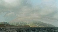
Gökçeada or Imroz Adasi, the the Greek Imvros (Ίμβρος) or Imbros is a mountainous island a few miles N of the Dardanelles. In prehistoric times (2 century BC), the island was associated with the Kabeiroi or Cabeiri. Their origin is rather obscure, they could be associated with the Great Gods worshipped in Samothrace, or, according to a later source they were the offsprings of Hephaestos.
In ancient times (c 300 BC) there were several temples dedicated to Hermes and a noteworthy aqueduct. The island was colonized by Athenians. During modern times, Imvros (Gökçeada), like it smaller neighbor Tenedos (Bozcaada), it was inhabited by Greeks and it was part of Greece until 1923 when it was ceded to Turkey under the terms of a peace treaty. The Greek inhabitants were not exchanged (as was the case elsewhere) but were allowed to stay and operate their schools and churches. The letter of this treaty was not followed and most Greeks were coerced to leave. Today there are a small (about 300) but very dedicated Greek minority living on the island.
Until a few years ago the island was a military zone and visits by foreign yachts was prohibited. Now yachts are invited.
Charts
- BA
- 1086 Srimonikos kólpos to Edremit Körfezi
- Imray-Tetra
- G2 Aegean Sea (North)
- NIMA
- 54360 Thessaloniki to Canakkale Bogazi Dardanelles
- 54369 Approaches to Canakkale Bogazi
- Turkey
- 2134 Anafartalar Koyu - Tavşan Island
- Greek
- 32 Thrakiko Sea
- 322 Limnos & Ay. Efstratios
Radio Nets
Also see Cruiser's Nets
Submit details of local radio Nets.
Weather
See Aegean Sea.
The approaches to Gökçeada are straightforward, no dangers.
Check-in facilities (Customs and Immigration)
There are no customs here. The nearest port of entry/exit is Çanakkale.
Ports and Popular Stops
Ports
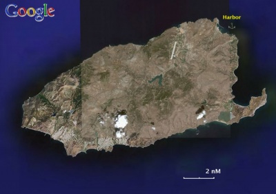
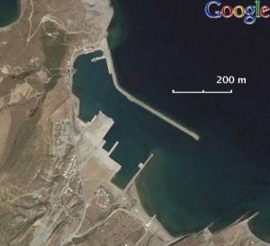
There is only one harbor (GPS: 40°13.6′N, 25°57.5′E). Go inside or at the end of the inner mole, as the other side is used by the ferry boats.
Anchorages
None.
Marinas & Yacht Clubs
None.
Yacht Services and Repairs
Marine Stores
None.
Yacht Services/Repairs/Yards
None.
Fuel, Water, & Electricity
- Fuel
- N/A (Not Available)
- Water
- There is an outlet on the quay
- Electricity
- N/A
Offshore Islands
None.
Tourism and Things to do Ashore
Tourism
There are several picturesque villages with some restored houses. The main town of Gökçeada is dreary.
Grocery & Supply Stores
- Very limited
Eateries
- There is a very nice restaurant in the mountainous village of Agridia the Barba Yiorgis (tel. +90 286 887 35 92)
Internet/WiFi
N/A.
Motorbike & Car Rentals
N/A.
Laundry
N/A.
Garbage Disposal
There are bins around the harbor.
Transportation
Ferries to Çanakkale.
Cruiser's Friends
Contact details of "Cruiser's Friends" that can be contacted for local information or assistance.
Forum Discussions
List links to discussion threads on partnering forums. (see link for requirements)
External Links
- Gökçeada (Wikipedia)
References & Publications
See Turkey.
Last Visited & Details Checked (and updated here)
Date of member's visit to this Port/Stop & this page's details validated:
- August 1999 --Istioploos

Personal Notes
Personal experiences?
|
|---|
|
Names: |
| |
|---|
| | HOMEPAGE | Wiki Contents | Mediterranean |Aegean Sea | Turkey | Gokceada | |


