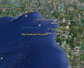
Gulf of Guinea
From CruisersWiki
(→Gulf of Guinea Weather Information) |
Lighthouse (Talk | contribs) m (Text replace - "WIKI CONTENTS" to "Wiki Contents") |
||
| Line 117: | Line 117: | ||
! <h2 id="mp-itn-h2" style="margin:0; background:#cedff2; font-size:120%; font-weight:bold; border:1px solid #a3b0bf; text-align:left; color:#000; padding:0.2em 0.4em;">Cruising Wiki Navigation</h2> | ! <h2 id="mp-itn-h2" style="margin:0; background:#cedff2; font-size:120%; font-weight:bold; border:1px solid #a3b0bf; text-align:left; color:#000; padding:0.2em 0.4em;">Cruising Wiki Navigation</h2> | ||
|- | |- | ||
| - | |style="color:#000;"| | [[World Cruising and Sailing Wiki|HOMEPAGE]] | [[Cruising| | + | |style="color:#000;"| | [[World Cruising and Sailing Wiki|HOMEPAGE]] | [[World Cruising Guides|Wiki Contents]] | [[South Atlantic]] | [[Africa]] | [[Middle Africa]] | [[Gulf of Guinea]] | |
|} | |} | ||
[[Category:Regions]] | [[Category:Regions]] | ||
Revision as of 11:23, 7 June 2011
Gulf of Guinea Cruising Guide
An online cruising guide for yachts that are sailing around the Gulf of Guinea
|
A sea port for eleven different nations and an oil-political hotspot, the Gulf of Guinea would seem to be an interesting place to visit.
| Countries and Islands in the Gulf of Guinea | Countries and Islands (cont) | Ports in the Gulf of Guinea | Ports in the Gulf (cont) |
|---|---|---|---|
| Angola Democratic Republic of the Congo | Equatorial Guinea | Accra | Sao Tome |
Traveling distances from the Romanche Trench, Latitude: 0°31.99 S Longitude: 20°18.17 W
| NW nm ° Porto Inglés (Cabo Verde) 955 349 | NE nm ° Conakry - Port 721 33 | SW nm ° Natal (Brasil) 946 250 | SE nm ° Cap Lopez 1740 90 |
Gulf of Guinea Weather Information
General weather conditions in the region
Sources for weather information:
The following forecasters' websites are those that specifically provide Cruisers with weather related to daily activities and journeys - also provision has been made to cover Tropical Storms. As with many web-sites of this type - it may be necessary to navigate the site to acquire specific information. In addition, updates will be required to correct frequent changes to the URLS.
Regional Radio Nets
- Mediteranian Maritime Mobile Net. Med. 7.085Mhz @ 0700hrs zulu
- U.K. M/M Net. U.K. Covers UK waters, Med & Atlantic. 14.303+/- QRMhz @ 0800hrs zulu & 1800hrs zulu
- Maritime Mobile Service Net. Covers the Atlantic from Cape Town to Greenland, the Eastern Pacific and the Gulf of Mexico. 14.300Mhz @ 1700hrs zulu till 0200hrs zulu during winter and during the summer from 1600 hrs z to 0200hrs zulu
Also see World Cruiser's Nets
References
Books, Guides, etc.
Forum Discussions
List links to discussion threads on partnering forums. (see link for requirements).
External Links
Personal Notes
Personal experiences?
| |
|---|
| | HOMEPAGE | Wiki Contents | South Atlantic | Africa | Middle Africa | Gulf of Guinea | |
