Jelsa
From CruisersWiki
(→Provisioning) |
Istioploos (Talk | contribs) (Template) |
||
| Line 1: | Line 1: | ||
{{IsPartOf|Mediterranean|Adriatic Sea|Croatia|Central Dalmatia|Hvar}} | {{IsPartOf|Mediterranean|Adriatic Sea|Croatia|Central Dalmatia|Hvar}} | ||
{{TOC block}} | {{TOC block}} | ||
| + | |||
{{Infobox | {{Infobox | ||
| lat=43.16107|lon=16.69343 | | lat=43.16107|lon=16.69343 | ||
| - | | | + | | name= Jelsa |
| - | | zoom= | + | | zoom= 14 |
| chartlet=y | | chartlet=y | ||
| image= JelsaHarbour.jpg | | image= JelsaHarbour.jpg | ||
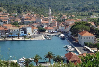
| - | | imagetext= Harbour of Jelsa from E | + | | imagetext= Harbour of Jelsa from E |
| - | + | | summary= The harbour of [[Jelsa]] is situated on the N coast of [[Hvar]] Island in [[Croatia]], a mile SE of the port and marina of [[Vrboska]]. The harbour is a ferry port and popular tourist destination, with an attractive location ringed with pine forests and some fine sandy coves along the neighbouring coast. Although the outer edges of the bay are now lined with tourist hotels, the old town at the head of the bay is still picturesque, with narrow streets and old stone houses and there is an interesting fortified church dating back to the 14th century. | |
| - | + | ||
| - | The harbour of Jelsa is situated on the N coast of [[Hvar]] Island in [[Croatia]], a mile SE of the port and marina of [[Vrboska]]. | + | |
The harbour provides good berthing options for visiting yachts, with around 18 laid moorings on its N quay and up to 20 additional moorings are located at the E section of the S quay. | The harbour provides good berthing options for visiting yachts, with around 18 laid moorings on its N quay and up to 20 additional moorings are located at the E section of the S quay. | ||
| - | + | The shelter is good in all but strong winds from N or NE. | |
| + | | notes= | ||
| + | | news= | ||
| + | }} | ||
==Charts== | ==Charts== | ||
| - | + | ''See [[Central Dalmatia#Charts|Central Dalmatia]]''. | |
| - | | | + | |
| - | + | ||
| - | + | ||
| - | + | ||
==Weather== | ==Weather== | ||
| Line 27: | Line 25: | ||
==Communication== | ==Communication== | ||
| + | {{Green|Add here VHF channel for the coastguard, harbor masters. etc.}} | ||
* | * | ||
| + | * | ||
''Also see [[World MM Nets|World Cruiser's Nets]]''. | ''Also see [[World MM Nets|World Cruiser's Nets]]''. | ||
==Navigation== | ==Navigation== | ||
| - | There are no dangers in the immediate approach to Jelsa. | + | There are no dangers in the immediate approach to [[Jelsa]]. Depths in the harbour entrance are 6.0 metres and on the quays 3.0 - 4.0 metres. The shelter is good in all conditions except strong NE winds, which can make the harbour dangerous. The harbour is subject to wash from tripper boats and ferries, especially during the morning. |
==Entrance== | ==Entrance== | ||
| - | [[Stari Grad]] is the nearest summer port of entry. At other times of year, [[Split]] | + | [[Stari Grad]] is the nearest summer port of entry. At other times of the year, [[Split]] and [[Korčula]] are the nearest year-round ports of entry. |
| + | {{hold vertical}} | ||
==Berthing== | ==Berthing== | ||
| - | |||
| - | |||
| - | |||
| - | |||
Visiting yachts berth where directed. There are currently three main berthing options in Jelsa: | Visiting yachts berth where directed. There are currently three main berthing options in Jelsa: | ||
{{poi | {{poi | ||
| - | | type= | + | | type= harbour |
| name=N quay projecting section | | name=N quay projecting section | ||
| lat=43.16263|lon=16.69354 | | lat=43.16263|lon=16.69354 | ||
| + | | zoom= 17 | ||
| url= | | url= | ||
| - | | | + | | image= JelsaYachtQuay1.jpg |
| - | The best but most popular berthing spot is on the short projecting section of quay on the N side of the harbour, where there is space for around 6 yachts stern or bows-to on laid moorings. Depths are 3.0 - 3.5 metres. | + | | imagetext= The ''projecting'' section of the N quay |
| + | | text=The best but most popular berthing spot is on the short projecting section of the quay on the N side of the harbour, where there is space for around 6 yachts stern or bows-to on laid moorings. Depths are 3.0 - 3.5 metres. There are water and electricity points on the quay. | ||
{{note}} There are two cafés on this section of the quay, so earplugs are an advantage if staying overnight. | {{note}} There are two cafés on this section of the quay, so earplugs are an advantage if staying overnight. | ||
}} | }} | ||
| + | |||
| + | {{hold vertical}} | ||
{{poi | {{poi | ||
| - | | type= | + | | type= harbour |
| name=N quay recessed section | | name=N quay recessed section | ||
| lat=43.16296|lon=16.69441 | | lat=43.16296|lon=16.69441 | ||
| + | | zoom= 17 | ||
| url= | | url= | ||
| - | | | + | | image= JelsaYachtQuay2.jpg |
| - | Immediately E of this projecting section is a long section of quay in front of the green-painted building. | + | | imagetext= The ''recessed'' section of the N quay,<br /> the port authority building is on the left |
| + | | text=Immediately E of this projecting section is a long section of the quay in front of the green-painted building. There are 12 further moorings here in depths of 3.0 metres. | ||
| + | While there are a couple of cafés here also, they tend to be less noisy. There are water and electricity points on this quay also. | ||
}} | }} | ||
| + | {{hold vertical}} | ||
| + | |||
{{poi | {{poi | ||
| - | | type= | + | | type= harbour |
| name=S quay | | name=S quay | ||
| lat=43.16162|lon=16.69465 | | lat=43.16162|lon=16.69465 | ||
| + | | zoom= 17 | ||
| url= | | url= | ||
| - | | | + | | image= JelsaSQuay.jpg |
| - | The section of quay to the east, some 100 metres long, provides some 20 moorings. | + | | imagetext= The S quay before its full completion |
| + | | text=The section of quay to the east, some 100 metres long, provides some 20 moorings. Water and electricity points are installed there as well. | ||
| - | This quay is somewhat more exposed in N winds than the N quay (although both quays suffer from swell in fresh to strong N winds). | + | This quay is somewhat more exposed in N winds than the N quay (although both quays suffer from the swell in fresh to strong N winds). |
| - | The westernmost section of the south quay, including the short jetty, is used by ferries and tripper boats and there are no moorings here. | + | The westernmost section of the south quay, including the short jetty, is used by ferries and tripper boats and there are no moorings here. Outside the peak season of July and August, it may be possible to go alongside here. |
}} | }} | ||
| - | {{ | + | {{Note}}The port authority building with showers and toilets is located between the abovementioned sections of the N quay. |
| + | |||
| + | ===Marinas & Yacht Clubs=== | ||
| + | None. | ||
==Anchorages== | ==Anchorages== | ||
| - | There is no suitable sheltered overnight anchorage close to Jelsa (although it is possible in settled weather to anchor outside the harbour in 7.0 – 8.0 metres, where the holding is moderate to good in sand and weed). | + | There is no suitable sheltered overnight anchorage close to Jelsa (although it is possible in settled weather to anchor outside the harbour in 7.0 – 8.0 metres, where the holding is moderate to good in sand and weed). [[Vrboska#Anchorages|Vrboska]] offers better overnight anchorages. |
| + | |||
| + | ''Also, see the [[Hvar]] Island page for other anchorages''. | ||
==Amenities== | ==Amenities== | ||
| Line 85: | Line 98: | ||
|header|Facilities | |header|Facilities | ||
| - | |Water| on the quays | + | |Water| {{mark | type= water |name= ||text= Points on the quays}} |
| - | |Electricity| | + | |Electricity| {{mark | type= electricity |name= ||text= Points on the quays}} |
| - | |Toilets| | + | |Toilets| At the port authority building |
| - | |Showers| | + | |Showers| At the port authority building |
| - | |Laundry| | + | |Laundry| N/A (Not Available) |
|Garbage| Near the harbour | |Garbage| Near the harbour | ||
|header|Supplies | |header|Supplies | ||
| - | |Fuel| | + | |Fuel| N/A |
|Bottled gas| None | |Bottled gas| None | ||
|Chandlers| None | |Chandlers| None | ||
| Line 100: | Line 113: | ||
|header|Services | |header|Services | ||
| - | |Repairs| | + | |Repairs| N/A |
| - | |Internet| | + | |Internet|WiFi in several restaurants and cafés |
| - | + | |Mobile connectivity| {{Green|Is there mobile telephone signal such as G4, G3, GPRS on the island? How strong is the signal? Are there any blind spots?}} | |
| - | |Mobile connectivity| | + | |Vehicle rentals| {{mark | type= car |name= In the town |text= Car and scooter rental outlets}} |
| - | |Vehicle rentals| Car and scooter rental outlets | + | |
|Health| | |Health| | ||
}} | }} | ||
==Provisioning== | ==Provisioning== | ||
| - | + | {{mark | |
| - | + | ||
| type=provisions | | type=provisions | ||
| name=Konzum | | name=Konzum | ||
| lat=43.16197|lon=16.6893 | | lat=43.16197|lon=16.6893 | ||
| url= | | url= | ||
| - | | text= | + | | text= a supermarket next to the bus station |
| - | + | ||
}} | }} | ||
| - | + | ||
| + | {{mark | ||
| type=provisions | | type=provisions | ||
| name=Ribola | | name=Ribola | ||
| lat=43.16196|lon=16.68901 | | lat=43.16196|lon=16.68901 | ||
| url= | | url= | ||
| - | | text= | + | | text=yet another supermarket at the same location |
| - | + | ||
}} | }} | ||
| + | |||
| + | {{mark| type=provisions| name=In the Town | text=Supermarket, butchers and other provisions shops in the town. Fruit and vegetable market.}} | ||
==Eating out== | ==Eating out== | ||
| - | Numerous restaurants and café/bars ashore. | + | * In the Town |
| + | : {{mark |name= | type= eatingout |text=Numerous restaurants and café/bars ashore.}} | ||
==Transportation== | ==Transportation== | ||
| - | * Passenger ferry to [[Bol]] on [[ | + | * Passenger ferry to [[Bol]] on [[Brač]] island and [[Split]] |
| - | * [http://tzjelsa.hr/en/jelsa/where/car/ Buses] to the [[Hvar (town)|town of Hvar]], [[Stari Grad]], [[Vrboska]], [[Sućuraj]] and then as far as to [[Split]] | + | * [http://tzjelsa.hr/en/jelsa/where/car/ Buses] to the [[Hvar (town)|town of Hvar]], [[Stari Grad]], [[Vrboska]], [[Sućuraj]] and then as far as to [[Split]] |
==Tourism== | ==Tourism== | ||
| - | |||
{{Image right| JelsaTown.jpg| Waterfront of Jelsa }} | {{Image right| JelsaTown.jpg| Waterfront of Jelsa }} | ||
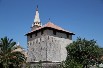
{{Image right| JelsaChurch.jpg| Jelsa has an unusual fortified church }} | {{Image right| JelsaChurch.jpg| Jelsa has an unusual fortified church }} | ||
| - | The old town is attractive to explore, with its original mediaeval street plan and several 17th and 18th century stone houses. | + | The old town is attractive to explore, with its original mediaeval street plan and several 17th and 18th century stone houses. The church of ''Sts. Fabian'' and ''Sebastian'' was fortified in the 15th century against Turkish and pirate attacks and contains a beautiful carved wooden altarpiece. There are some superb walks through pine forests and on into the surrounding mountains or along the coast to the port of [[Vrboska]]. |
==Links== | ==Links== | ||
| Line 152: | Line 164: | ||
{{Comments}} | {{Comments}} | ||
| + | * | ||
| + | * | ||
{{Verified by}} | {{Verified by}} | ||
| - | |||
* July 2014 --[[User:Atheneoflymington|Athene of Lymington]] | * July 2014 --[[User:Atheneoflymington|Athene of Lymington]] | ||
* Sep 2018 --[[User:Vadim|Vadim]] | * Sep 2018 --[[User:Vadim|Vadim]] | ||
Latest revision as of 19:01, 19 April 2019
| Jelsa
| |
| | |
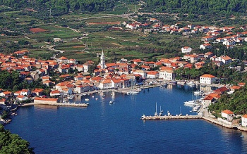
The harbour of Jelsa is situated on the N coast of Hvar Island in Croatia, a mile SE of the port and marina of Vrboska. The harbour is a ferry port and popular tourist destination, with an attractive location ringed with pine forests and some fine sandy coves along the neighbouring coast. Although the outer edges of the bay are now lined with tourist hotels, the old town at the head of the bay is still picturesque, with narrow streets and old stone houses and there is an interesting fortified church dating back to the 14th century.
The harbour provides good berthing options for visiting yachts, with around 18 laid moorings on its N quay and up to 20 additional moorings are located at the E section of the S quay.
The shelter is good in all but strong winds from N or NE.
Charts
See Central Dalmatia.
Weather
See Croatia.
Communication
Add here VHF channel for the coastguard, harbor masters. etc.
Also see World Cruiser's Nets.
There are no dangers in the immediate approach to Jelsa. Depths in the harbour entrance are 6.0 metres and on the quays 3.0 - 4.0 metres. The shelter is good in all conditions except strong NE winds, which can make the harbour dangerous. The harbour is subject to wash from tripper boats and ferries, especially during the morning.
Entrance
Stari Grad is the nearest summer port of entry. At other times of the year, Split and Korčula are the nearest year-round ports of entry.
Berthing
Visiting yachts berth where directed. There are currently three main berthing options in Jelsa:
N quay projecting section
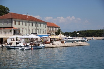
The best but most popular berthing spot is on the short projecting section of the quay on the N side of the harbour, where there is space for around 6 yachts stern or bows-to on laid moorings. Depths are 3.0 - 3.5 metres. There are water and electricity points on the quay.
Note: There are two cafés on this section of the quay, so earplugs are an advantage if staying overnight.N quay recessed section
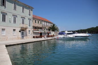
Immediately E of this projecting section is a long section of the quay in front of the green-painted building. There are 12 further moorings here in depths of 3.0 metres.
While there are a couple of cafés here also, they tend to be less noisy. There are water and electricity points on this quay also.S quay
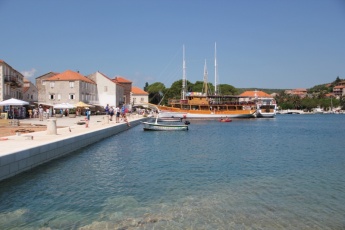
The section of quay to the east, some 100 metres long, provides some 20 moorings. Water and electricity points are installed there as well.
This quay is somewhat more exposed in N winds than the N quay (although both quays suffer from the swell in fresh to strong N winds).
The westernmost section of the south quay, including the short jetty, is used by ferries and tripper boats and there are no moorings here. Outside the peak season of July and August, it may be possible to go alongside here.Note: The port authority building with showers and toilets is located between the abovementioned sections of the N quay.
Marinas & Yacht Clubs
None.
Anchorages
There is no suitable sheltered overnight anchorage close to Jelsa (although it is possible in settled weather to anchor outside the harbour in 7.0 – 8.0 metres, where the holding is moderate to good in sand and weed). Vrboska offers better overnight anchorages.
Also, see the Hvar Island page for other anchorages.
Amenities
| Facilities | |
|---|---|
| Water | |
| Electricity | |
| Toilets | At the port authority building |
| Showers | At the port authority building |
| Laundry | N/A (Not Available) |
| Garbage | Near the harbour |
| Supplies | |
| Fuel | N/A |
| Bottled gas | None |
| Chandlers | None |
| Services | |
| Repairs | N/A |
| Internet | WiFi in several restaurants and cafés |
| Mobile connectivity | Is there mobile telephone signal such as G4, G3, GPRS on the island? How strong is the signal? Are there any blind spots? |
| Vehicle rentals | |
| Health | |
Provisioning
![]() Konzum [[Jelsa#Konzum|Konzum]] 43°09.718'N, 016°41.358'E a supermarket next to the bus station
Konzum [[Jelsa#Konzum|Konzum]] 43°09.718'N, 016°41.358'E a supermarket next to the bus station
![]() Ribola [[Jelsa#Ribola|Ribola]] 43°09.718'N, 016°41.341'E yet another supermarket at the same location
Ribola [[Jelsa#Ribola|Ribola]] 43°09.718'N, 016°41.341'E yet another supermarket at the same location
![]() In the Town [[Jelsa#In the Town|In the Town]] Supermarket, butchers and other provisions shops in the town. Fruit and vegetable market.
In the Town [[Jelsa#In the Town|In the Town]] Supermarket, butchers and other provisions shops in the town. Fruit and vegetable market.
Eating out
- In the Town
-
 [[Jelsa# | ]] Numerous restaurants and café/bars ashore.
Transportation
- Passenger ferry to Bol on Brač island and Split
- Buses to the town of Hvar, Stari Grad, Vrboska, Sućuraj and then as far as to Split
Tourism
The old town is attractive to explore, with its original mediaeval street plan and several 17th and 18th century stone houses. The church of Sts. Fabian and Sebastian was fortified in the 15th century against Turkish and pirate attacks and contains a beautiful carved wooden altarpiece. There are some superb walks through pine forests and on into the surrounding mountains or along the coast to the port of Vrboska.
Links
- Jelsa at the Wikipedia
- Tourist Board of Jelsa
For other useful websites, see Croatia.
References
See Croatia.
Comments
We welcome users' contributions to the Wiki. Please click on Comments to view other users' comments, add your own personal experiences or recommend any changes to this page following your visit.
Verified by
Date of member's last visit to Jelsa and this page's details validated:
- July 2014 --Athene of Lymington
- Sep 2018 --Vadim
| This is a usable page of the cruising guide. However, please contribute if you can to help it grow further. Click on Comments to add your personal notes on this page or to discuss its contents. Alternatively, if you feel confident to edit the page, click on the edit tab at the top and enter your changes directly. |
| |
|---|
|
Names: Lighthouse, Athene of Lymington |
