Kalamos
From CruisersWiki
| Kalamos
| |
| | |
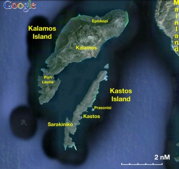
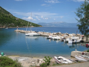
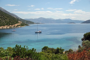
The small Greek island of Kalamos (Kálamos - Κάλαμος) lies eight miles SE of the island of Lefkas in the so-called ‘Inland Sea’ enclosed by the islands of Levkas, Ithaca and Kefalonia on the west and the Greek mainland on the east. Together with these other islands and the smaller islands of Meganisi five miles to the NW and Kastos just one mile to the SE, Kalamos is a popular overnight stop for yachts cruising the area between the Lefkas Canal and the Gulf of Patras. The main settlement of Kalamos town is on the E side of the island, just over half way from its southernmost tip, and offers good shelter in winds from most directions (although strong easterlies can cause problems and may even make the harbour untenable). The harbour has space for around 30 yachts moored stern/bows-to on its long E breakwater and W quay. The village to the W is pleasant rather than picturesque and has a modest amount of tourism, mostly from local Greeks. Other berthing options are the anchorage of Port Leone at the S end of the island or the tiny harbour of Episkopi on the N coast.
Charts
- BA
- 203 Nisos Zakinthos to Nisos Paxoi
- Imray-Tetra
- G12 Nísos Levkas to Nísos Zákinthos
- G121 Inland Sea Ionian
- NIMA
- 54280 Corfu Channel to Nisis Proti
- Greek
- 30 Kefalonia, Ithaki
Weather
- See Ionian Sea Weather.
- Also see Ionian Sea Currents & Tides.
The harbour of Kalamos offers good shelter in all except E and SE winds, which send in an uncomfortable swell and can make the harbour untenable if very strong. In summer, katabatic winds may be experienced from the high mountains W of the harbour.
Passages
Islands
Communication
- Coast Guard - VHF channel 12
- Olympia Radio - VHF channel 03
Also see World Cruiser's Nets.
The island is mountainous and easily spotted from distance. In the approach from S, round the cape of Ak. Kafali, the shoal of Ifalos Formikoula just under a mile W is to be avoided. The approach from N has no hazards, although there are isolated rocks close inshore which are easily avoided by staying at least 100 metres offshore. The channel between Kalamos and its immediate neighbour, Kastos, can sometimes be subject to gusting in strong NW winds. Approaching the harbour from S, a series of prominent windmills, including one right on the shore, mark the headland immediately SW of the harbour. The harbour is entered from N between a long, curved eastern breakwater and a shorter western one. Depths in the entrance are 3.5 – 4.0 metres and on the quays from 2.5 to 3.5 metres.
Entrance
A yacht cannot clear in at Kalamos. Lefkas is the nearest port of entry.
Berthing
Ports
Port Kalamos
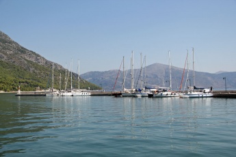
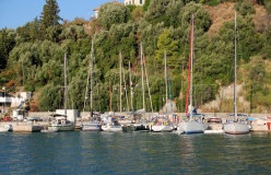
Port Kalamos, down hill from the village of Kalamos, is the main harbour on the island and fills up rapidly during high season, when the charter business is in full swing. A yacht has four mooring options, depending on time of arrival and draft:
- Stern/bows-to the outermost length of the quay on the southern breakwater, between the end and the first ‘elbow’, using the anchor. Depths here are around 3.0 metres. The quay is equipped with small iron bollards and mooring rings set into the wall but nothing else. There is space here for around 6-8 yachts and it is the most popular place to berth because of the depth (although more subject to any swell with anything E in the wind).
- Stern/bows-to the third length of this quay, between the second and the third ‘elbow’, again using the anchor. Depths here are around 2.5 metres. The quay is equipped with concrete bollards in varying states of repair but nothing else. There is space here for a further 8-10 yachts and it is the second most popular place to berth.
- Stern/bows-to the second length of the quay, between the first and second ‘elbow’, again using the anchor. Depths here are around 2.0 – 2.5 metres, but there is rock ballasting in several places which reduces depths to only a metre; hence these berths tend to be occupied only when the others are full and deeper draft yachts will need to anchor off and take a line ashore. This quay is also equipped with concrete bollards, some in a poor state of repair but nothing else. There is space here for around 8-10 yachts.
- Stern/bows-to the quay on the W side of the harbour, wherever there is space, using the anchor. Depths here are 2.5 metres and the quay is equipped with iron bollards and mooring rings. If mooring here, care is needed not to foul the anchors of yachts on the breakwater opposite. Holding in the harbour is good in mud and weed.
George (owner of the taverna at the S. corner) is an informal harbourmaster, helping yachts to moor and arranging rafting when harbour over over fills. He expects the visitors to come over to his restaurant, but it is not compulsory. Phone: + 30 2646 091358; +30 697 0994602
Episkopi
Marinas & Yacht Clubs
None.
Anchorages
Port Leone
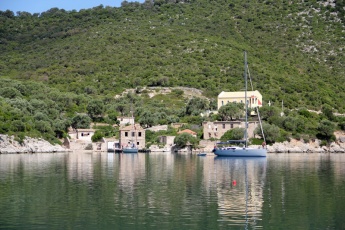
Port Leone is the former harbour of the island, which was deserted following the 1953 earthquake, which destroyed the water supply. Of the ruins, only the church remains. A yacht has three options here:
- Free anchor in the cove immediately N of the deserted village in 10-12 metres. Good shelter in the prevailing winds.
- Anchor in the cove to the S of the village in 6.0 - 7.0 metres, preferably taking a line ashore. Good shelter in the prevailing winds but gusts in the evening. Note that a fisherman occasionally lays nets part way across the entrance to the cove, which can be passed on the W side.
- Anchor immediately S of the village, taking a line ashore to either of the two wooden jetties. Depths at the end of the jetties are 2.0 – 2.5 metres. No more than two yachts can moor in this way (and not on 1 July or 15 August, when pilgrims visit the church). Lines are attached to ropes tied through the planking on the jetties.
Amenities
| Facilities | |
|---|---|
| Water | Port Kalamos: via long hose from ferry quay |
| Electricity | N/A (Not Available) |
| Toilets | At George’s Taverna |
| Showers | At George’s Taverna |
| Laundry | N/A |
| Garbage | Bins near the harbours |
| Supplies | |
| Fuel | N/A |
| Bottled gas | N/A |
| Chandlers | None |
| Services | |
| Repairs | N/A |
| Internet | Wifi at George’s Taverna and Cafe Il Panino |
| Mobile connectivity | 3G Signa |
| Vehicle rentals | N/A |
Provisioning
![]() Port Kalamos [[Kalamos#Port Kalamos|Port Kalamos]] Minimarket and greengrocer on the W quay with limited provisions.
Port Kalamos [[Kalamos#Port Kalamos|Port Kalamos]] Minimarket and greengrocer on the W quay with limited provisions.
- Bakery up in the village, next to George's restaurant a steep road up. As of 2020 a new bakery at port level.
- Two small supermarkets at the port (check expiration dates when purchasing goods).
Eating out
-
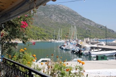
 George’s Taverna [[Kalamos#George’s Taverna|George’s Taverna]] at the S end of the harbour is virtually an institution for visiting yotties. George is the friendly character who probably helped you berth on arrival and has tended to the mooring and dining needs of generations of yachtsmen cruising the Inland Sea.
Transportation
Ferries to Kastos and Astakos on mainland.
Tourism
The village of Kalamos winding up the steep slopes above the harbour has its charms but is not especially picturesque. There are some nice walks to the N end of the island through stands of pine and eucalyptus trees.
Friends
Contact details of "Cruiser's Friends" that can be contacted for local information or assistance.
Forums
List links to discussion threads on partnering forums. (see link for requirements)
Links
- Kalamos at the Wikipedia
References
See Ionian Sea.
Comments
We welcome users' contributions to the Wiki. Please click on Comments to view other users' comments, add your own personal experiences or recommend any changes to this page following your visit.
- We visited during the first week of June 2014. Port Kalamost was choke full (mostly with SailingHolidays flotilla), so we anchored in Port Leone instead and spent a very peaceful night on anchor. --Dimrub 13:58, 8 June 2014 (BST)
Verified by
Date of member's last visit to Kalamos and this page's details validated:
- June 2013 --Athene of Lymington 10:36, 16 June 2013 (BST)
- June 2014 --Dimrub 13:58, 8 June 2014 (BST)

- Sept 2014 --Monterey

- Sept 2021 -- Timmema1
| This is a usable page of the cruising guide. However, please contribute if you can to help it grow further. Click on Comments to add your personal notes on this page or to discuss its contents. Alternatively, if you feel confident to edit the page, click on the edit tab at the top and enter your changes directly. |
| |
|---|
|
Names: Athene of Lymington |
