Lapseki
From CruisersWiki
Istioploos (Talk | contribs) (Headings) |
Istioploos (Talk | contribs) (Chartlet) |
||
| Line 1: | Line 1: | ||
| - | + | {{Infobox |40|21.0|N|26|41.0|E| | |
| - | + | | mapzoom= 15 | |
| - | + | | image= LapsekiQuay.jpg | |
| - | + | | imagetext= Quay at Lapseki - ''Click for larger view'' | |
| - | + | }} {{TOCleft}} | |
| - | + | The new harbour of [http://en.wikipedia.org/wiki/Lapseki Lapseki] lies on the S shore of the Dardanelles, directly opposite the harbour of [[Gelibolu]] three miles W of the entrance to the [[Sea of Marmara]]. The harbour is a purpose-built fishing and small craft harbour enclosed by two breakwaters. | |
| - | + | ||
| - | | | + | |
| - | + | ||
| - | + | ||
| - | | | + | |
| - | + | ||
| - | + | ||
| - | | | + | |
| - | + | ||
| - | + | ||
Since its completion, the harbour of [[Gelibolu]] has been closed to yachts, which are now expected to moor in Lapseki. However, note that Lapseki is shallow and has minimum depths in the entrance of barely 3.0 metres. | Since its completion, the harbour of [[Gelibolu]] has been closed to yachts, which are now expected to moor in Lapseki. However, note that Lapseki is shallow and has minimum depths in the entrance of barely 3.0 metres. | ||
| Line 29: | Line 19: | ||
''Also see [[World MM Nets|World Cruiser's Nets]]''. | ''Also see [[World MM Nets|World Cruiser's Nets]]''. | ||
| - | |||
==Approach and Navigation== | ==Approach and Navigation== | ||
| - | |||
| - | |||
The new harbour lies half a mile N of the ferry terminal of Lapseki, which is easily identifiable from the numerous ferries plying the route across to [[Gelibolu]] on the N side of the straits. The harbour entrance is marked by two white light structures at the ends of the breakwaters and is entered from NNW along the line of a long sandy beach. The channel leading into the harbour is subject to silting and had least depths in May 2011 of about 3.0 metres with one patch of just 2.6 metres. Once inside, the bottom is uneven and depths range from 3.0 – 4.0 metres in the western part (the eastern part is shallow). | The new harbour lies half a mile N of the ferry terminal of Lapseki, which is easily identifiable from the numerous ferries plying the route across to [[Gelibolu]] on the N side of the straits. The harbour entrance is marked by two white light structures at the ends of the breakwaters and is entered from NNW along the line of a long sandy beach. The channel leading into the harbour is subject to silting and had least depths in May 2011 of about 3.0 metres with one patch of just 2.6 metres. Once inside, the bottom is uneven and depths range from 3.0 – 4.0 metres in the western part (the eastern part is shallow). | ||
==Berthing Options== | ==Berthing Options== | ||
| + | {{Image right|LapsekiEntrance.jpg |Entrance to Lapseki - ''Click for larger view'' }} | ||
| + | |||
There is a quay at the E end of the harbour, but this is invariably filled with local fishing boats, often rafted two or three deep. | There is a quay at the E end of the harbour, but this is invariably filled with local fishing boats, often rafted two or three deep. | ||
| Line 102: | Line 91: | ||
==External Links== | ==External Links== | ||
| - | * [http://en.wikipedia.org/wiki/Lapseki Lapseki] | + | * [http://en.wikipedia.org/wiki/Lapseki Lapseki] at the Wikipedia |
* | * | ||
| Line 110: | Line 99: | ||
==Personal Note== | ==Personal Note== | ||
* Lapseki is a good, well sheltered anchorage for shallow to moderate draft yachts, but has little else to offer.--[[User:Atheneoflymington|Athene of Lymington]] 17:10, 18 May 2011 (BST) | * Lapseki is a good, well sheltered anchorage for shallow to moderate draft yachts, but has little else to offer.--[[User:Atheneoflymington|Athene of Lymington]] 17:10, 18 May 2011 (BST) | ||
| + | * | ||
====Last Visited & Details Checked (and updated here)==== | ====Last Visited & Details Checked (and updated here)==== | ||
| Line 117: | Line 107: | ||
| - | {{ | + | {{Page useable}} |
| - | + | {{Contributors|[[User:Atheneoflymington|Athene of Lymington]]}} | |
| - | { | + | |
| - | + | ||
| - | | | + | |
| - | + | ||
| - | + | ||
| - | + | ||
| - | + | ||
| - | + | {{Navbar| [[Mediterranean]] | [[Turkey]] | [[Dardanelles]] | [[Lapseki]] }} | |
| - | { | + | |
| - | + | ||
| - | + | ||
| - | + | ||
| - | + | ||
[[Category:Ports - Turkey]] | [[Category:Ports - Turkey]] | ||
Revision as of 20:06, 18 May 2015
| Lapseki
| |
|
The new harbour of Lapseki lies on the S shore of the Dardanelles, directly opposite the harbour of Gelibolu three miles W of the entrance to the Sea of Marmara. The harbour is a purpose-built fishing and small craft harbour enclosed by two breakwaters.
Since its completion, the harbour of Gelibolu has been closed to yachts, which are now expected to moor in Lapseki. However, note that Lapseki is shallow and has minimum depths in the entrance of barely 3.0 metres.
Local Weather
See Turkey.
Charts
See Dardanelles.
Radio Nets
Also see World Cruiser's Nets.
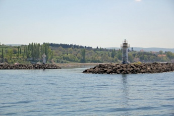
The new harbour lies half a mile N of the ferry terminal of Lapseki, which is easily identifiable from the numerous ferries plying the route across to Gelibolu on the N side of the straits. The harbour entrance is marked by two white light structures at the ends of the breakwaters and is entered from NNW along the line of a long sandy beach. The channel leading into the harbour is subject to silting and had least depths in May 2011 of about 3.0 metres with one patch of just 2.6 metres. Once inside, the bottom is uneven and depths range from 3.0 – 4.0 metres in the western part (the eastern part is shallow).
Berthing Options
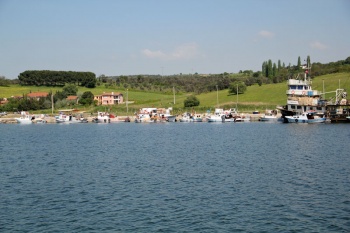
There is a quay at the E end of the harbour, but this is invariably filled with local fishing boats, often rafted two or three deep.
A yacht is best to anchor off in the middle of the harbour, where depths are around 3.0 – 3.5 metres and holding good in sand and weed.
Marinas & Yacht Clubs
None.
Anchorages
Inside the harbour.
Offshore Islands
None.
Yacht Repairs and Services
Marine Stores
None.
Repairs/Yards
None
Fuel, Water, & Electricity
- Fuel
- N/A (Not Available)
- Water
- N/A
- Electricity
- N/A
Things to do Ashore
Tourism
There is little of tourist interest ashore. The nearest shops and restaurants are about 15-20 minutes walk to the S near the ferry terminal.
Grocery & Supply Stores
See note above.
Eateries
See note above.
Internet/WiFi
None.
Laundry
None.
Motorbike & Car Rentals
Garbage Disposal
?
Transportation
- Ferries to Gelibolu
Routes/Passages To/From
Cruiser's Friends
Contact details of "Cruiser's Friends" that can be contacted for local information or assistance.
Forum Discussions
List links to discussion threads on partnering forums. (see link for requirements)
External Links
- Lapseki at the Wikipedia
References & Publications
See Turkey.
Personal Note
- Lapseki is a good, well sheltered anchorage for shallow to moderate draft yachts, but has little else to offer.--Athene of Lymington 17:10, 18 May 2011 (BST)
Last Visited & Details Checked (and updated here)
Date of member's visit to this Port/Stop & this page's details validated:
- May 2011 --Athene of Lymington 16:37, 18 May 2011 (BST)
| This is a usable page of the cruising guide. However, please contribute if you can to help it grow further. Click on Comments to add your personal notes on this page or to discuss its contents. Alternatively, if you feel confident to edit the page, click on the edit tab at the top and enter your changes directly. |
| |
|---|
|
Names: Athene of Lymington |
| Cruising Wiki Navigation
|
|---|
| | HOMEPAGE | Wiki Contents | Mediterranean | Turkey | Dardanelles | Lapseki | |

