Liberia
From CruisersWiki
Please remove the below item if you have provided some content material for this page
| HELP! This section is lagging behind in development.
|
|---|
| Your assistance is required to develop these pages into a useful resource. Bring out the hidden "cruising guide writer" in you and share your information here (in the true cruising spirit) for all who follow in your wake. |
| Liberia
| |
| Capital | Monrovia |
|---|---|
| Language | English |
| Currency | Liberian Dollar (LRD) |
| Time zone | GMT (UTC+0) |
| Calling code | +231 |
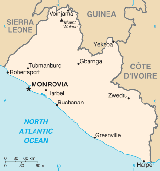
Liberia, officially the Republic of Liberia, is a country on the West African coast. It is bordered by Sierra Leone to its northwest, Guinea to its north, Ivory Coast to its east, and the Atlantic Ocean to its south-southwest. It covers an area of 111,369 square kilometers (43,000 sq mi) and has a population of around 4,700,000 people. English is the official language and over 20 indigenous languages are spoken, representing the numerous ethnic groups who make up more than 95% of the population. The country's capital and largest city is Monrovia.
Liberia began as a settlement of the American Colonization Society (ACS), who believed black people would face better chances for freedom and prosperity in Africa than in the United States. The country declared its independence on July 26, 1847.
Charts
- British Admiralty
- BA3139 - Monrovia to Sassandra
- BA3162 - Harper to Sassandra
- BA3164 - Monrovia to Greenville
- BA3165 - Greenville to Harper
- NOAA
- 51640 - Cape Mount to Cestos River
- 51660 - Cestos River to Cape Palmas
Weather
The equatorial climate is hot year-round with heavy rainfall from May to October with a short interlude in mid-July to August. During the winter months of November to March dry dust-laden harmattan winds blow inland causing many problems for residents.
Weather links
Sources of weather forecasting here.
Passages
List popular passages/routes, timing, etc.
Communication
Add here VHF channel for coastguard, harbor masters. etc.
Also see Cruiser's Nets
Any navigation notes here. If this section does not apply remove it.
Entrance
Arrival
Details?
Departure
Details?
Customs and Immigration
Customs
Details?
Immigration
Details?
Fees and Charges
Restrictions
Health and Security
Health
In 2014 there was an Ebola outbreak.
Security
Details?
Berthing
Ports
- Monrovia
Marinas & Yacht Clubs
None.
Anchorages
List anchorages except the ones covered under Offshore Islands below. If there is more then 2 paragraphs for a given anchorage, create a dedicated page for it (Port/Stop Template).
Transportation
- Roberts International Airport (ROB IATA) (often called Roberts International Airport or RIA) is located some 60 km from the city center of Monrovia at Robertsfield.
Friends
Contact details of "Cruiser's Friends" that can be contacted for local information or assistance.
Forums
List links to discussion threads on partnering forums. (see link for requirements)
Links
References
- Steve Jones, Ed Wheeler, and Penny Scott-Bayfield, Cruising Guide To West Africa, Royal Cruising Club Pilotage Foundation (December 2009), ISBN 978-0952777120
Comments
We welcome users' contributions to the Wiki. Please click on Comments to view other users' comments, add your own personal experiences or recommend any changes to this page following your visit.
- Liberia is a favoured country for registration of ships, along with Panama. --Haiqu
Verified by
Date of member's last visit to Liberia and this page's details validated:
If you provide a lot of info and this page is almost complete, change {{Page outline}} to {{Page useable}}.
| This page has an outline in place but needs completing. Please contribute if you can to help it grow further. Click on Comments to suggest further content or alternatively, if you feel confident to edit this page, click on the edit tab at the top and enter your changes directly. |
| |
|---|
|
Names: Lighthouse |

