Mljet
From CruisersWiki
| Mljet
| |
| | |
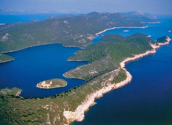
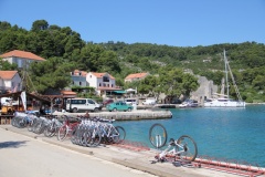
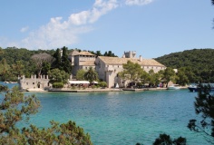
Mljet Island lies off the mainland coast of Croatia, at the S end of the long chain of Dalmatian islands that ends at the port of Dubrovnik. Mljet is the closest of the larger islands to the resort of Dubrovnik and is consequently one of the most visited, especially by day trippers. However, its paucity of accommodation means that the island is tranquil once the tripper boats return to base. The northwestern part of the island—scenically the most beautiful—belongs to the ![]() National park Mljet [[Mljet#National park Mljet|National park Mljet]] which has been established since 1960 and, apart from a few restaurants, a hotel, some national park buildings and a converted Benedictine monastery on an island in the lake of Veliko Jezero, no development has been allowed. There are no marinas on the island, just a scattering of small harbours and anchorages (almost all along the N coast) whose quays, where they exist, are largely dominated by restaurant moorings. Although its harbours and anchorages are very busy with visiting yachts during the summer, Mljet is the highlight of a cruise in the Dalmatian islands for most people.
National park Mljet [[Mljet#National park Mljet|National park Mljet]] which has been established since 1960 and, apart from a few restaurants, a hotel, some national park buildings and a converted Benedictine monastery on an island in the lake of Veliko Jezero, no development has been allowed. There are no marinas on the island, just a scattering of small harbours and anchorages (almost all along the N coast) whose quays, where they exist, are largely dominated by restaurant moorings. Although its harbours and anchorages are very busy with visiting yachts during the summer, Mljet is the highlight of a cruise in the Dalmatian islands for most people.
Charts
See Southern Dalmatia.
Weather
See Croatia.
Passages
See Croatia.
Islands
Communication
Add here VHF channel for coastguard, harbor masters. etc.
Also see World Cruiser's Nets
Add any navigation notes such approaches, dangers etc here. If this section does not apply, remove it.
Entrance
Dubrovnik is the nearest year-round port of entry.
Berthing
There are a total of eight principal berthing options on the island, the main harbour of Polace at the NW end, then anti-clockwise around the island the harbours of Pomena, Okuklje, Sobra and Kozarica, plus anchorages at U. Saplunara, U. Veli Skolj and U. Prozura.
Ports
The harbours on Mljet are listed anti-clockwise from the main port of Polace:
- Kozarica |
 – harbour |
Marinas & Yacht Clubs
None.
Anchorages
The main anchorages are towards the E end of the island and are as follows:
U. Saplunara
U. Veli Skolj
The anchorage of U. Veli Skolj lies at the easternmost end of the island, between the coast and the two offshore islets of ![]() Veli Skolj [[Mljet#Veli Skolj|Veli Skolj]] 42°42.363'N, 017°44.905'E and
Veli Skolj [[Mljet#Veli Skolj|Veli Skolj]] 42°42.363'N, 017°44.905'E and ![]() Mali Skolj [[Mljet#Mali Skolj|Mali Skolj]] 42°42.223'N, 017°44.676'E . The anchorage offers reasonable shelter in settled weather but should be avoided with anything E in the wind. Anchor in 4.0 - 7.0 metres in the channel wherever there is space. Holding is good in sand.
Mali Skolj [[Mljet#Mali Skolj|Mali Skolj]] 42°42.223'N, 017°44.676'E . The anchorage offers reasonable shelter in settled weather but should be avoided with anything E in the wind. Anchor in 4.0 - 7.0 metres in the channel wherever there is space. Holding is good in sand.
U. Prozura
The bay of U. Prozura is situated on the N coast of the island, just under a mile W of the harbour of Okuklje. The bay is partly sheltered from the N by the islets of ![]() Planjak [[Mljet#Planjak|Planjak]] 42°44.088'N, 017°39.027'E and
Planjak [[Mljet#Planjak|Planjak]] 42°44.088'N, 017°39.027'E and ![]() Borovac [[Mljet#Borovac|Borovac]] 42°44.339'N, 017°39.062'E . The safest approach is on the W side of Planjak, as the E side has dangerous shoals. In the smaller E cove, there is a tiny quay at Konoba Marijina with just two berths, which is however too shallow for most yachts, which use one of the six marked mooring buoys in the same cove if patronising the establishment. The quay of Konoba Barba in the main cove has four laid moorings in depths of just 1.5 - 1.8 metres, plus a further four marked yellow mooring buoys in 5.0 - 6.0 metres for patrons. There are four additional (unmarked) orange mooring buoys further out in 10 metres, which can also be picked up. If anchoring, it will probably be necessary to drop in around 10 metres to avoid the mooring buoys. The holding is good in sand and weed. Shelter in the bay is good in virtually all conditions, although there is a swell with strong N winds.
Borovac [[Mljet#Borovac|Borovac]] 42°44.339'N, 017°39.062'E . The safest approach is on the W side of Planjak, as the E side has dangerous shoals. In the smaller E cove, there is a tiny quay at Konoba Marijina with just two berths, which is however too shallow for most yachts, which use one of the six marked mooring buoys in the same cove if patronising the establishment. The quay of Konoba Barba in the main cove has four laid moorings in depths of just 1.5 - 1.8 metres, plus a further four marked yellow mooring buoys in 5.0 - 6.0 metres for patrons. There are four additional (unmarked) orange mooring buoys further out in 10 metres, which can also be picked up. If anchoring, it will probably be necessary to drop in around 10 metres to avoid the mooring buoys. The holding is good in sand and weed. Shelter in the bay is good in virtually all conditions, although there is a swell with strong N winds.
- Take care in the very north east of the smaller east cove. We picked up a discarded anchor chain with our anchor --Zebahdy of London - Aug 2015).
Amenities
| Facilities | |
|---|---|
| Water |
|
| Electricity |
|
| Toilets | ? |
| Showers | ? |
| Laundry | N/A (Not Available) |
| Garbage |
|
| Supplies | |
| Fuel | |
| Bottled gas | None |
| Chandlers | None |
| Services | |
| Repairs | N/A |
| Internet |
|
| Mobile connectivity | Is there mobile telephone signal such as G4, G3, GPRS on the island? How strong is the signal? Are there any blind spots? |
| Vehicle rentals |
|
Provisioning
![]() Polače [[Mljet#Polače|Polače]] 42°47.244'N, 017°22.273'E Basic provisions shops in the village.
Polače [[Mljet#Polače|Polače]] 42°47.244'N, 017°22.273'E Basic provisions shops in the village.
![]() Pomena [[Mljet#Pomena|Pomena]] 42°47.264'N, 017°20.545'E Two small minimarkets.
Pomena [[Mljet#Pomena|Pomena]] 42°47.264'N, 017°20.545'E Two small minimarkets.
![]() Okuklje [[Mljet#Okuklje|Okuklje]] 42°43.638'N, 017°40.272'E Small provisions shop on the N quay.
Okuklje [[Mljet#Okuklje|Okuklje]] 42°43.638'N, 017°40.272'E Small provisions shop on the N quay.
![]() Sobra Village quay [[Mljet# Sobra Village quay| Sobra Village quay]] Small provisions shop near the quay.
Sobra Village quay [[Mljet# Sobra Village quay| Sobra Village quay]] Small provisions shop near the quay.
Eating out
-
 [[Mljet# | ]] 42°47.193'N, 017°22.825'E Several restaurants (six as of 2014) along the quays, most with their own moorings. Café/bar near the Roman castle ruins.
-
 [[Mljet# | ]] 42°47.333'N, 017°20.669'E Several restaurants on the E quay, all with their own moorings.
-
 [[Mljet# | ]] 42°47.255'N, 017°20.604'E Restaurant and café/bar in the hotel.
-
 Maestral [[Mljet#Maestral|Maestral]] The jetty of the restaurant is found immediately on the right when entering the bay. Ten yachts can tie up to the moorings and there are two buoys in the bay. The family restaurant, now run by the third generation, is located on the opposite the S shore 10 minutes on foot from the pier. A transfer by dinghy is possible. On the roofed restaurant terrace grilled sardines, goat cheese, mussels from Sobra, Scampi buzara, a brodetto of scorpionfish, risotto and, if pre-ordered, octopus or lamb Peka are served. For dessert, the chocolate soufflé is noteworthy, amongst others. The cook is the son, who studies at the gastronomic academy. Open 1300 - 2400 from 1 April to 1 November. Wifi. --Luksa2.
-
 [[Mljet# | ]] There are several restaurants around the bay, most with their own moorings.
-
 Konoba Lanterna [[Mljet#Konoba Lanterna|Konoba Lanterna]] This restaurant has been recommended for helpful service.--Athene of Lymington.
-
 [[Mljet# | ]] Three restaurants in the village, two with their own moorings.
Transportation
Regular ferries to Dubrovnik on mainland from Sobra.
Tourism
Places to Visit
The ‘must see’ attractions of Mljet Island are the two interconnected lakes, Malo and Veliko Jezero, at the NW end of the island. The lakes are in the national park and an entry fee of 100 kuna (2014) per person is payable on berthing in Polace or Pomena (though not if only dining at the restaurants). This price includes entry to the park (valid for a week), a bus to and from Veliko Jezero and access (via a short boat ride) to the former Benedictine monastery of Sv. Marija, which is being steadily restored following damage during Croatia's war of independence and has a cafe and restaurant.
It is also possible to walk or cycle the route to and around the lakes (cycles can be hired in the villages or at the lakes themselves), which is a much more rewarding if a rather more energetic option. Between the two lakes is a channel dug by the Benedictine monks to provide motive power for a mill from the tidal currents into Veliko Jezero. Depending on the state of the tide, a current can be seen rushing through the shallow sea inlet at the E end of Veliko Jezero, the pleasant walk or cycle to which goes along the S or N side of the lake. Except when the current is very strong, a ferry boat takes pedestrians and cyclists (with their bikes) across the narrows to enable them to complete the circuit of the lakes. In Polace the main attractions are the remains of a Roman palace, dating back to the 5th or 6th centuries, which are conspicuous on the W side of the bay. Next, to the ruins are the remains of a 5th century early Christian basilica.
Friends
Contact details of "Cruiser's Friends" that can be contacted for local information or assistance.
Forums
List links to discussion threads on partnering forums. (see link for requirements)
Links
See Croatia.
References
See Croatia.
Comments
We welcome users' contributions to the Wiki. Please click on Comments to view other users' comments, add your own personal experiences or recommend any changes to this page following your visit.
Verified by
Date of member's last visit to Mljet and this page's details validated:
- June 2014 --Athene of Lymington
- August 2015 -- Zebahdy of London
| This is a usable page of the cruising guide. However, please contribute if you can to help it grow further. Click on Comments to add your personal notes on this page or to discuss its contents. Alternatively, if you feel confident to edit the page, click on the edit tab at the top and enter your changes directly. |
| |
|---|
|
Names: Lighthouse, Athene of Lymington |


