Nicaragua
From CruisersWiki
Lighthouse (Talk | contribs) |
Lighthouse (Talk | contribs) |
||
| Line 21: | Line 21: | ||
===Background=== | ===Background=== | ||
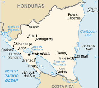
| - | + | The country is bordered by [[Honduras]] to the north and by [[Costa Rica]] to the south. The Pacific Ocean lies to the west of the country, while the [[Caribbean]] Sea lies to the east. Falling within the tropics, Nicaragua sits 11 degrees north of the Equator, in the Northern Hemisphere. | |
| + | |||
| + | The [[Caribbean]] coastline is much more sinuous than its generally straight Pacific counterpart. Lagoons and deltas make it very irregular. Nicaragua's tropical east coast is very different from the rest of the country. The climate is predominantly tropical, with high temperature and high humidity. Around the area's principal city of Bluefields, English is widely spoken along with the official Spanish and the population more closely resembles that found in many typical [[Caribbean]] ports than the rest of Nicaragua. | ||
| + | |||
| + | Cruising/sailing in the region? | ||
===Climate & Weather=== | ===Climate & Weather=== | ||
| Line 60: | Line 64: | ||
===Ports & Popular Stops=== | ===Ports & Popular Stops=== | ||
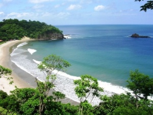
| + | [[Image:Nicaragua_Pacific_Beach.jpg|right|thumb|300px|A pacific beach in Nicaragua]] | ||
* '''Caribbean Coast''' | * '''Caribbean Coast''' | ||
** | ** | ||
Revision as of 14:32, 24 May 2008
Nicaragua Cruising Guide
| Nicaragua | |
 Nicaragua | |
 Flag | |
| Capital: | Managua |
|---|---|
| Language: | Spanish |
| Currency: | Cordoba |
| More notes about the country | |
Background
The country is bordered by Honduras to the north and by Costa Rica to the south. The Pacific Ocean lies to the west of the country, while the Caribbean Sea lies to the east. Falling within the tropics, Nicaragua sits 11 degrees north of the Equator, in the Northern Hemisphere.
The Caribbean coastline is much more sinuous than its generally straight Pacific counterpart. Lagoons and deltas make it very irregular. Nicaragua's tropical east coast is very different from the rest of the country. The climate is predominantly tropical, with high temperature and high humidity. Around the area's principal city of Bluefields, English is widely spoken along with the official Spanish and the population more closely resembles that found in many typical Caribbean ports than the rest of Nicaragua.
Cruising/sailing in the region?
Climate & Weather
Nicaragua has a tropical climate with generally hot and humid conditions. Temperatures are around or just above 30 degrees Celcius during the day most of the year and most areas are still above 20 degrees Celcius at night. Nicaragua has two seasons regarding rainfall. A dry and slightly cooler November to April season and a wet season (but not raining all day) during May to October. Hurricanes occasionally hit the country from July/August onwards.
Sources of weather forecasting:
Charts
Submit details of the charts required for safe navigation of the area.
Any navigation notes here.
Local Radio Nets
Also see World Cruiser's Nets
Submit details of Cruiser's Nets and VHF operating/calling channels here.
Arrival/Departure procedures
Submit any details about advance notification of arrival, etc.
Immigration, Visas & Customs
Immigration
Details
Customs
Details
Health
Details
Security
Details
Ports & Popular Stops
- Caribbean Coast
- Pacific Coast
Offshore Islands
Details?
Cruiser's Friends
Submit details/contacts of cruiser's "friends" that can be contacted in advance or on arrival - who can offer information and assistance to our cruising "family".
References & Publications
Books, Guides, etc.
Links to CruiserLog Forum discussions
Links to discussions on the CruiserLog Forum
External Links
Submit useful website links for the region
Personal Notes
Personal experiences?
.
