North Atlantic
From CruisersWiki
Istioploos (Talk | contribs) (→References & Publications: References) |
Istioploos (Talk | contribs) (Interactive Map) |
||
| Line 1: | Line 1: | ||
===NORTH ATLANTIC CRUISING GUIDE=== | ===NORTH ATLANTIC CRUISING GUIDE=== | ||
| - | + | ||
An online cruising guide for yachts sailing in the North Sea. | An online cruising guide for yachts sailing in the North Sea. | ||
| + | |||
| + | <imagemap> | ||
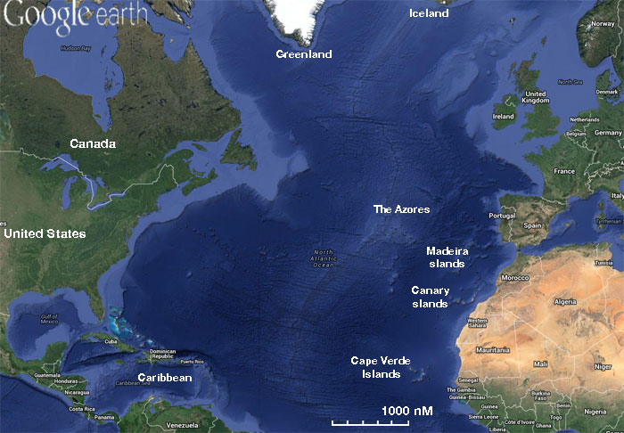
| + | Image:NorthAtlantic.jpg|frame|center|<center>Map of the North Atlantic - <em>For details click on a name or an area</em></center> | ||
| + | poly 15 348 113 362 128 345 237 412 230 445 55 471 [[Caribbean]] | ||
| + | poly 1 172 99 207 97 238 189 192 208 229 113 362 1 349 [[United States]] | ||
| + | poly 1 163 69 175 107 208 103 231 189 183 205 208 295 192 219 1 1 1 [[Canada]] | ||
| + | rect 291 1 381 69 [[Greenland]] | ||
| + | rect 447 1 529 25 [[Iceland]] | ||
| + | rect 645 1 700 77 [[Norway]] | ||
| + | rect 667 77 700 114 [[Denmark]] | ||
| + | poly 568 85 591 132 582 160 631 151 631 131 601 59 [[United Kingdom]] | ||
| + | poly 549 121 573 103 583 114 581 158 561 143 548 137 [[Ireland]] | ||
| + | poly 635 129 660 124 658 142 658 149 638 145 [[Netherlands]] | ||
| + | poly 640 148 657 149 655 164 635 153 [[Belgium]] | ||
| + | poly 653 123 680 115 700 110 700 178 662 197 671 169 661 165 663 143 [[Germany]] | ||
| + | poly 587 176 633 150 668 173 654 197 665 218 636 227 613 222 611 195 [[France]] | ||
| + | poly 558 232 559 215 605 221 636 233 606 271 574 268 583 232 [[Spain]] | ||
| + | poly 547 234 581 236 573 275 547 275 [[Portugal]] | ||
| + | rect 577 276 589 283 [[Gibraltar]] | ||
| + | rect 414 218 491 245 [[Azores|Azores Islands]] | ||
| + | rect 470 269 533 300 [[Madeira|Madeira Islands]] | ||
| + | poly 530 351 577 285 607 290 611 308 558 354 [[Morocco]] | ||
| + | rect 453 317 513 346 [[Canaries|Canaries Islands]] | ||
| + | poly 528 352 547 359 546 372 537 378 534 387 507 385 [[Western Sahara]] | ||
| + | poly 549 355 565 354 565 345 583 361 581 416 519 413 513 387 546 388 [[Mauritania]] | ||
| + | rect 387 393 483 430 [[Cape Verde|Cape Verde Islands]] | ||
| + | rect 507 419 537 431 [[Senegal]] | ||
| + | rect 500 433 537 441 [[The Gambia]] | ||
| + | rect 499 443 536 441 [[Guinea-Bissau]] | ||
| + | poly 525 455 549 448 562 446 569 472 569 475 544 455 534 464 [[Guinea]] | ||
| + | poly 523 460 537 466 543 462 555 471 543 481 [[Sierra Leone]] | ||
| + | poly 544 482 559 471 572 486 592 486 [[Liberia]] | ||
| + | </imagemap> | ||
| + | |||
| + | {{TOCleft}} | ||
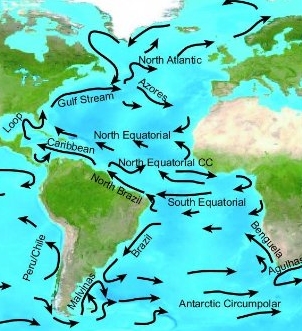
[[Image:Atlantic_Ocean_Currents.jpg|frame|right|Currents of the Atlantic Ocean]] | [[Image:Atlantic_Ocean_Currents.jpg|frame|right|Currents of the Atlantic Ocean]] | ||
| Line 30: | Line 65: | ||
{| class="wikitable" style="margin: 1em auto 1em auto;" | {| class="wikitable" style="margin: 1em auto 1em auto;" | ||
|- bgcolor="#ABCDEF" align="center" | |- bgcolor="#ABCDEF" align="center" | ||
| - | | '''Countries''' || '''Countries''' || '''Countries''' || Islands<br />& Groups | + | | '''Countries'''<br />'''Europe''' || '''Countries'''<br />'''Africa''' || '''Countries'''<br />'''America''' || '''Islands'''<br />'''& Groups''' |
|- | |- | ||
|id "Countries1" valign="top" | | |id "Countries1" valign="top" | | ||
| - | : [[ | + | : [[Norway]] |
| + | : [[Denmark]] | ||
| + | : [[United Kingdom]] | ||
: [[Ireland]] | : [[Ireland]] | ||
| - | : [[ | + | : [[Netherlands|Netherlands or Holland]] |
| - | : [[ | + | : [[Belgium]] [[image:Question_icon.png]] |
| + | : [[Germany]] | ||
: [[France|France]] | : [[France|France]] | ||
| + | : [[Spain|Spain]] | ||
| + | : [[Portugal|Portugal]] | ||
| + | : [[Gibraltar]] | ||
|id "Countries2" valign="top" | | |id "Countries2" valign="top" | | ||
| - | : [[ | + | : [[Morocco]] [[image:Question_icon.png]] |
| - | + | ||
: [[Western Sahara]] [[image:Question_icon.png]] | : [[Western Sahara]] [[image:Question_icon.png]] | ||
: [[Mauritania]] [[image:Question_icon.png]] | : [[Mauritania]] [[image:Question_icon.png]] | ||
| - | : [[Senegal]] | + | : [[Senegal]] [[image:Question_icon.png]] |
| - | : [[The Gambia]] | + | : [[The Gambia]] [[image:Question_icon.png]] |
: [[Guinea-Bissau]] | : [[Guinea-Bissau]] | ||
| + | : [[Guinea]] [[image:Question_icon.png]] | ||
: [[Sierra Leone]] [[image:Question_icon.png]] | : [[Sierra Leone]] [[image:Question_icon.png]] | ||
: [[Liberia]] [[image:Question_icon.png]] | : [[Liberia]] [[image:Question_icon.png]] | ||
| Line 60: | Line 101: | ||
: [[South America]] (portion) | : [[South America]] (portion) | ||
: [[Central America]] | : [[Central America]] | ||
| - | : [[United States | + | : [[United States]] |
| - | : [[Canada | + | : [[Canada]] |
: [[Greenland]] [[image:Question_icon.png]] | : [[Greenland]] [[image:Question_icon.png]] | ||
: [[Iceland]] [[image:Question_icon.png]] | : [[Iceland]] [[image:Question_icon.png]] | ||
| Line 67: | Line 108: | ||
|id "Islands" valign="top" | | |id "Islands" valign="top" | | ||
: [[Caribbean]] | : [[Caribbean]] | ||
| - | : [[Saint-Pierre_and_Miquelon|Saint-Pierre | + | : [[Saint-Pierre_and_Miquelon|Saint-Pierre & Miquelon Islands]] [[image:Question_icon.png]] |
| - | : [[Faroe Islands]] | + | : [[Faroe Islands]] [[image:Question_icon.png]] |
| - | : [[Azores|Azores]] | + | : [[Azores|Azores]] [[image:Question_icon.png]] |
: [[Madeira|Madeira]] | : [[Madeira|Madeira]] | ||
: [[Canaries|The Canaries]] | : [[Canaries|The Canaries]] | ||
| Line 82: | Line 123: | ||
* [[Trans-Atlantic, Europe to Caribbean]] | * [[Trans-Atlantic, Europe to Caribbean]] | ||
* [[Trans-Atlantic, Caribbean to Europe Passage]] | * [[Trans-Atlantic, Caribbean to Europe Passage]] | ||
| - | * [[Passage_North_ Atlantic-W-E|Trans-Atlantic | + | * [[Passage_North_ Atlantic-W-E|Trans-Atlantic - Canada to Europe]] |
| - | * [[Passage_North_ Atlantic-E-W|Trans-Atlantic | + | * [[Passage_North_ Atlantic-E-W|Trans-Atlantic - Europe to Canada]] |
===Forum Discussions=== | ===Forum Discussions=== | ||
| Line 106: | Line 147: | ||
| - | {{ | + | {{Guide2}} |
| Line 124: | Line 165: | ||
|style="color:#000;"| | [[World Cruising and Sailing Wiki|HOMEPAGE]] | [[World Cruising Guides|Wiki Contents]] | [[North Atlantic]] | | |style="color:#000;"| | [[World Cruising and Sailing Wiki|HOMEPAGE]] | [[World Cruising Guides|Wiki Contents]] | [[North Atlantic]] | | ||
|} | |} | ||
| - | |||
[[Category:Regions]] | [[Category:Regions]] | ||
Revision as of 02:53, 6 March 2015
NORTH ATLANTIC CRUISING GUIDE
An online cruising guide for yachts sailing in the North Sea.
|
The Atlantic Ocean is bounded on the West by North and South America. In the North and Northeast, it is separated from the Arctic Ocean by the Canadian Arctic Archipelago, Greenland, Iceland, Jan Mayen, Svalbard, and mainland Europe. It connects to the Arctic Ocean through the Denmark Strait, Greenland Sea, Norwegian Sea, and Barents Sea. To the East, the boundaries of the ocean proper are Europe, the Strait of Gibraltar (where it connects with the Mediterranean Sea, one of its marginal seas, and, in turn, the Black Sea), and Africa. In the Southeast, the Atlantic merges into the Indian Ocean, the border being defined by the 20° East meridian, running South from Cape Agulhas to Antarctica. While some authorities show the Atlantic Ocean extending south to Antarctica, others show it as bounded at the 60° parallel by the Southern Ocean. In the southwest, the Drake Passage connects it to the Pacific Ocean. A man-made link between the Atlantic and Pacific is provided by the Panama Canal. Beside those mentioned, other large bodies of water adjacent to the Atlantic are the Caribbean Sea, the Gulf of Mexico, Hudson Bay, the Arctic Ocean, the Mediterranean Sea, the North Sea, the Baltic Sea, and the Celtic Sea.
Covering approximately 22% of Earth's surface, the Atlantic Ocean is second only to the Pacific Ocean in size. With its adjacent seas it occupies an area of about 106,400,000 square kilometers (41,100,000 sq mi); without them, it has an area of 82,400,000 square kilometres (31,800,000 sq mi).
Submit details about the sailing in the area, etc.
North Atlantic Charts
See North Atlantic Pilot Charts.
Radio Nets
Also see World Cruiser's Nets.
Weather
General seasonal weather conditions?
List sources for weather information
Countries and Islands
| Countries Europe | Countries Africa | Countries America | Islands & Groups |
Passages
Popular passages & best timing, etc. (E - West & W - East)
- Trans-Atlantic, Europe to Caribbean
- Trans-Atlantic, Caribbean to Europe Passage
- Trans-Atlantic - Canada to Europe
- Trans-Atlantic - Europe to Canada
Forum Discussions
List links to discussion threads on partnering forums. (see link for requirements)
References & Publications
- Anne Hammick: RCC Pilotage Foundation, Atlantic Islands Cruising Guide: Azores, Madeira Group, Canary Islands and Cape Verdes, Imray Laurie Norie & Wilson; 5th ed edition (December 11, 2011), ISBN 978-1846233364
- Anne Hammick and Gavin McLaren: RCC Pilotage Foundation, Atlantic Crossing Guide, Adlard Coles; Sixth Edition edition (October 1, 2010), ISBN 9781408113806
- Jimmy Cornell, World Cruising Routes, International Marine/Ragged Mountain Press; 6 edition (March 14, 2008), ISBN 978-0071592895
- Jimmy Cornell, World Cruising Handbook: Covering All the Maritime Nations of the World, Adlard Coles Nautical; 3rd edition (July 31, 2001), ISBN 978-0713658279
External Links
Links to relevant websites.
- Greenland route info is about half way down page http://www.freewebs.com/seawrite/worldsailing2.htm
Personal Notes
Personal experiences?
|
|---|
|
Names: Lighthouse, Magwas |
| |
|---|
| | HOMEPAGE | Wiki Contents | North Atlantic | |


