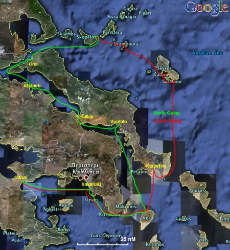
Passages between Athens Region and the North Sporades
From CruisersWiki
Passages between Athens Region and the N. Sporades
| Athens to N. Sporades | |
| MORE notes about the passage |
Introduction
The south going passage from the Northern Sporades group of islands to the Athens Region is fairly easy with mostly favorable winds. You may chose the longer, and less interesting route via the Gulf of Evia, or the preferred direct route via the island of Skyros and the Kafireas Strait. While his route avoids possible delays at Halkis, you may have to wait in Skyros so that you can avoid possible rough seas in the Kafireas Strait.
The north going passage from the Athens Region to the Northern Sporades group of islands is more complicated. You have the weigh the strong possibility of strong meltemi contrary winds and rough seas via the Kafireas Strait and Skyros versus the longer and less exiting route via the Gulf of Evia with possible delays, up to 2 days, for the opening of the Bridge. Nevertheless, this is the recomended route for going north.
Climate & Weather Information
See Aegean Weather.
Weather Windows
In general, the best sailing in the Aegean Sea is during the period from late May to mid October. But this does not preclude earlier in the Spring or later in the Autumn. Sailing in the winter months can be problematic due to stronger, more volatile, and less predictable weather.
Radio Nets
See Aegean Sea.
- Goast Guard - VHF channel 12 tel. +30 22210 28888 (Halkis)
BA 1062 Nísoi Voríoi Sporádhes
Imray-Tetra G14 Saronic and Argolic Gulfs
Imray-Tetra G25 Eastern Sporades and North Evvoia
NIMA 54348 Vorios Evoikos Kolpos and Notios Evoikos Kolpos
Greek 31 North Evoikos to Kavala Gulf
Greek 74 Corinth to Skopelos Island
Greek 331 Sporades to Ay. Efstratios
See also Aegean Sea.
Distance & Duration
Possible Departure Points
- Marinas in the Attika Coast (Athens Region)
- Corinth Canal (37°54.91′N, 23°0.61′E)
Route/Suggested Stopovers
North Going via the Gulf of Evia
This is an easy passage but longer than the passage via the island of Skyros. However, the Gulf of Evia is not a very exiting cruising ground because its waters are not translucent as the waters of the Aegean Sea. Another drawback of this passage is the possibility of long delays, up to 2 days, for the opening of the Halkis Bridge. It highly recommended that a few days before your estimated arrival in Halkis you contact the Coast Guard (Λιμεναρχείο - Limenarchio) on either VHF channel 12 or by telephone in +30 22210 28888.
- The first convenient stopover after leaving the Attika Coast (Athens Region) is Vourkari in the island of Kea (37°40′N, 24°19.5′E), 34 nM from Kalamaki Marina (GPS: 37°54.7′N, 23°42.0′E) or 66 nM from the Corinth Canal (GPS: 37°54.91′N, 23°0.61′E).
- From Vourkari you sail for 42 nM NNW to the very sheltered creek of Voufalo in the island of Evia (GPS: 38°18′N, 24°07′E).
- Then, from Voufalo, sail 28 nM mostly NW to the south harbor of Halkis (GPS: 38°27.7′N, 23°35.3′E).
Here you will have to wait for the bridge to open. Stay in communication with the authorities in VHF channel 12.
Warning: When the bridge opens, it stays open for a very short time. You have to be fast to transit the narrow Euripus Channel.
Once you transit the narrows and are on the N side, you can either moor stern-to the NE town quay or anchor off on the NW shore. - From Halkis you continue sailing NW for 32 nM to the very pleasant and secluded small island of Atalanti (GPS: 38°40.3′N, 23°05.3′E).
- FromAtalanti sail first NW and then, at 38°50.4′N, 22°47.9′E, NE for a total of 37 nM to the sleepy little harbor of Orei in Evia (GPS: 38°57′N, 23°05′E).
- From Orei you can sail to of the Sporades islands either to:
- Skiathos (GPS: 39°09.9′N, 23°29.6′E), a 25 nM sail NE.
- Skopelos (GPS: 39°07.4′N, 23°44.1′E), a 44 nM sail ENE.
The total distance from Kalamaki Marina (37°54.7′N, 23°42.0′E) along the route outlined above is:
- Skiathos (39°09.9′N, 23°29.6′E) - 198 nM
- Skopelos (39°07.4′N, 23°44.1′E) - 219 nM
Possible Arrival Ports
- Skiathos (39°09.9′N, 23°29.6′E)
- Skopelos (39°07.4′N, 23°44.1′E)
- Marinas in the Attika Coast (Athens Region)
- Corinth Canal (37°54.91′N, 23°0.61′E)
CruiserLog Forum discussions
Links to discussions on the CruiserLog Forum
External Links
See Aegean Sea.
References
See Aegean Sea.
Personal Notes
I have sailed all of the above complete passages. --Istioploos ![]()
| |
|---|
| | HOMEPAGE | Wiki Contents | Mediterranean | Greece | Turkey | Aegean Sea | Passages: Athens Region - N. Sporades | |
.
