Porto Ercole
From CruisersWiki
m (bot: Move Communication) |
Istioploos (Talk | contribs) (Template) |
||
| Line 1: | Line 1: | ||
{{IsPartOf|Mediterranean|Italy|Tuscan Coast}} | {{IsPartOf|Mediterranean|Italy|Tuscan Coast}} | ||
{{TOC block}} | {{TOC block}} | ||
| - | {{Infobox |42 | + | |
| - | | zoom= | + | {{Infobox |
| + | | lat= 42.39409| lon=11.20972 | ||
| + | | name= Porto Ercole | ||
| + | | portofentry= y | ||
| + | | zoom= 15 | ||
| + | | chartlet = y | ||
| image= PortoErcole2.jpg | | image= PortoErcole2.jpg | ||
| - | | imagetext= Porto Ercole | + | | imagetext= Porto Ercole |
| - | + | | summary= The shallow harbour of '''Porto Ercole''' lies on the E side of the prominent Argentario peninsula on the Tuscan coast of [[Italy]]. The island of [[Giglio]] lies 12 miles WSW and the island of [[Elba]] just over 40 miles NW. The harbour here has over 800 berths on a series of privately managed pontoons. The harbour gets very busy during the summer season and it can be difficult to find space here. The [[Marina di Cala Galera]] half a mile N of Porto Ercole offers an alternative berthing possibility. The town’s main claim to fame is that it was almost certainly here that the celebrated artist Michelangelo Merisi da Caravaggio died on his way back to Rome from long exile in 1610. Remains discovered in the ossuary of the church of Sant’ Erasmo were demonstrated in 2010 using DNA and other scientific testing to be those of the revolutionary painter. | |
| - | The shallow harbour of Porto Ercole lies on the E side of the prominent Argentario peninsula on the Tuscan coast of [[Italy]]. | + | | notes= |
| + | | news= | ||
| + | }} | ||
| + | |||
==Charts== | ==Charts== | ||
| Line 21: | Line 29: | ||
Sources for weather information: | Sources for weather information: | ||
| - | * There is a continuous ( | + | * There is a continuous (computerized voice) weather forecast on VHF 68 - first in Italian and then followed with an English translation |
* The same forecast is given in Italian and English on VHF coastal stations following a notification on channel 16 | * The same forecast is given in Italian and English on VHF coastal stations following a notification on channel 16 | ||
* Navtex weather forecasts are broadcast from stations at La Garde (Toulon), Roma and Cagliari ([[Sardinia]]) | * Navtex weather forecasts are broadcast from stations at La Garde (Toulon), Roma and Cagliari ([[Sardinia]]) | ||
| Line 27: | Line 35: | ||
==Passages== | ==Passages== | ||
| - | + | ''See [[Mediterranean#Mediterranean_Passages|Mediterranean]]''. | |
| - | + | ||
==Islands== | ==Islands== | ||
| Line 35: | Line 42: | ||
==Communication== | ==Communication== | ||
| + | {{Green|Add here VHF channel for the coastguard, harbor masters. etc.}} | ||
* | * | ||
* | * | ||
| Line 44: | Line 52: | ||
==Entrance== | ==Entrance== | ||
| - | + | [[{{PAGENAME}}]] is a port of entry for Italy. For details ''see [[Italy#Entrance|Entrance: Italy]]''. | |
| - | |||
==Berthing== | ==Berthing== | ||
| + | The five pontoons are each operated by private concessions and it is unlikely a yacht in transit will find a berth there during busy periods. Smaller yachts in transit (maximum 12 metres, maximum draft 1.5 metres) can moor towards the outer end of the breakwater, where transit berthing is allowed for up to three days. Larger yachts will have to inquire at one of the pontoons (the centre pontoon has the greatest depth - 3.5 metres) or at the quay at the S side of the harbour (2.0 metres) for a berth. If there is space, the best berths are on the short T at the end of each pontoon, where there is room for 2/3 yachts on laid moorings. | ||
| - | |||
| - | |||
| - | |||
Each of the four pontoons is operated by a different club | Each of the four pontoons is operated by a different club | ||
On the pontoon far to your port when you enter the harbor is Emporio del Sub +39 (0)564 833486 | On the pontoon far to your port when you enter the harbor is Emporio del Sub +39 (0)564 833486 | ||
| - | On the | + | On the pontoon far to starboard is L'Approdo +39 (0)564 830176. We (Amusant 15.8 MY) stayed in mid-September. We were asked for €100 but with our moments hesitation, the price was reduced to €80. |
The middle pontoons Albatros and C N V A did not show phone numbers. | The middle pontoons Albatros and C N V A did not show phone numbers. | ||
| - | === | + | ===Marinas & Yacht Clubs=== |
| - | + | * [[Marina di Cala Galera]] | |
| - | == | + | ==Anchorages== |
| - | ==== | + | {{poi | lat= 42.40779| lon=11.21692 |
| - | + | | type= anchorage | |
| - | + | | name=N of Marina di Cala Galera | |
| + | | altname= | ||
| + | | url = | ||
| + | | zoom= 15 | ||
| + | | image= | ||
| + | | imagetext= | ||
| + | | text= The most sheltered anchorage in all but strong E winds is just N of [[Marina di Cala Galera]], where a yacht can anchor in 3.0 - 5.0 metres. Holding is good in sand and mud. | ||
| + | }} | ||
| - | == | + | ==Amenities== |
| - | + | {{tlist | |
| - | + | |header|Facilities | |
| - | + | ||
| - | + | |Water| Water on some of the pontoons (not at every berth) | |
| - | + | |Electricity| Electricity on some of the pontoons (not at every berth)} | |
| - | + | |Toilets| {{MagentaText|?}} | |
| + | |Showers| {{MagentaText|?}} | ||
| + | |Laundry| {{MagentaText|?}} | ||
| + | |Garbage| Bins near the pontoons | ||
| - | + | |header|Supplies | |
| + | |Fuel| Fuel station on the jetty just N of the pontoons (0730 - 0930 summer only)} | ||
| + | |Bottled gas| {{MagentaText|?}} | ||
| + | |Chandlers| {{MagentaText|?}} | ||
| - | + | |header|Services | |
| - | + | |Repairs| Slipway (500 T). Mobile crane (25 T). Fixed crane (5 T). Engine, electrical and electronic repairs. Wood and fiberglass repairs. Sail repairs. Divers | |
| - | + | |Internet| {{MagentaText|?}} | |
| + | |Mobile connectivity| {{MagentaText|?}} | ||
| + | |Vehicle rentals| {{MagentaText|?}} | ||
| + | }} | ||
| - | == | + | ==Provisioning== |
| - | * | + | * Supermarket and good provisions shopping in the town |
| - | * | + | * Fish market on the quay |
| - | == | + | ==Eating out== |
| - | + | Good restaurants in the town. | |
| - | ==== | + | ==Transportation== |
| - | * | + | * The Via Aurelia (E80) runs along the coast at the base of the Argentario Peninsula, 12 kilometres E of [[Porto Santo Stefano|Santo Stefano]] |
| + | * Train station at Orbetello, 11 kilometers E of [[Porto Santo Stefano|Santo Stefano]]. Trains to Rome and Pisa | ||
| - | == | + | ==Tourism== |
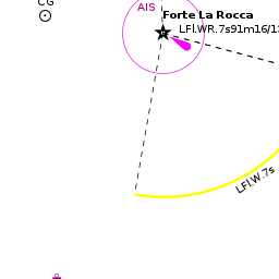
| - | + | The Spanish, who controlled the Peninsula in the 16th century, recognized the strategic significance of the natural harbour of Porto Ercole. Thus the bay is ringed with a series of powerful fortresses, from the fort of La Rocca at the southern end of the bay to the mighty citadel of Forte Filippo at the northern end. Further afield, there are some lovely walks around the Argentario Peninsula with superb views over the sea over to the Isola del [[Giglio]]. | |
| - | + | {{Image right| PortoErcoleTown.jpg| Porto Ercole, with the castle of La Rocca }} | |
| - | + | ||
| - | + | ||
| - | + | ||
| - | + | ||
| - | + | ||
==Friends== | ==Friends== | ||
| Line 115: | Line 131: | ||
==Links== | ==Links== | ||
* {{wikipedia}} | * {{wikipedia}} | ||
| + | * {{Wikivoyage}} | ||
* | * | ||
| Line 120: | Line 137: | ||
''See [[Italy#References & Publications|Italy]]''. | ''See [[Italy#References & Publications|Italy]]''. | ||
| - | {{Comments | + | {{Comments}} |
| + | * | ||
{{Verified by}} | {{Verified by}} | ||
| - | |||
* Data compiled from web research (please update if possible)--[[User:Atheneoflymington|Athene of Lymington]] 14:13, 7 December 2010 (UTC) | * Data compiled from web research (please update if possible)--[[User:Atheneoflymington|Athene of Lymington]] 14:13, 7 December 2010 (UTC) | ||
* | * | ||
| + | |||
| + | {{Green|If you provide a lot of info and this page is almost complete, change <nowiki>{{Page outline}} to {{Page useable}}</nowiki>.}} | ||
| Line 133: | Line 152: | ||
{{Contributors|[[User:Lighthouse|Lighthouse]], [[User:Atheneoflymington|Athene of Lymington]], [[User:Dapaz1|Dapaz1]]}} | {{Contributors|[[User:Lighthouse|Lighthouse]], [[User:Atheneoflymington|Athene of Lymington]], [[User:Dapaz1|Dapaz1]]}} | ||
| - | [[Category:Ports - Italy]] | + | [[Category:Ports - Italy]] [[Category:Marinas - Italy]] [[Category:Anchorages - Italy]] |
Revision as of 21:44, 21 May 2018
| Porto Ercole Port of Entry
| |
| |
 Porto Ercole |
The shallow harbour of Porto Ercole lies on the E side of the prominent Argentario peninsula on the Tuscan coast of Italy. The island of Giglio lies 12 miles WSW and the island of Elba just over 40 miles NW. The harbour here has over 800 berths on a series of privately managed pontoons. The harbour gets very busy during the summer season and it can be difficult to find space here. The Marina di Cala Galera half a mile N of Porto Ercole offers an alternative berthing possibility. The town’s main claim to fame is that it was almost certainly here that the celebrated artist Michelangelo Merisi da Caravaggio died on his way back to Rome from long exile in 1610. Remains discovered in the ossuary of the church of Sant’ Erasmo were demonstrated in 2010 using DNA and other scientific testing to be those of the revolutionary painter.
Charts
- British Admiralty
- 1999
- Italian
- 913
- 122
- 5
- 6
Weather
The prevailing winds along the Tuscan coast are from NW or W and are mostly moderate, rarely rising above force 5. Close inshore, a yacht will often encounter SE or even S winds, especially around the offshore islands, or long periods of calm. A depression passing to the N along the line of the Alps will sometimes cause a libeccio, a strong SW wind that occasionally reaches gale force and causes a heavy swell. In winter, the tramontana is a very strong N or NE wind that blows down off the Alps and can affect most of the NW coast of Italy.
Sources for weather information:
- There is a continuous (computerized voice) weather forecast on VHF 68 - first in Italian and then followed with an English translation
- The same forecast is given in Italian and English on VHF coastal stations following a notification on channel 16
- Navtex weather forecasts are broadcast from stations at La Garde (Toulon), Roma and Cagliari (Sardinia)
Passages
See Mediterranean.
Islands
Communication
Add here VHF channel for the coastguard, harbor masters. etc.
Also see World Cruiser's Nets.
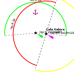
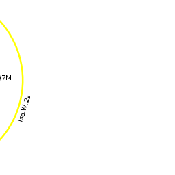
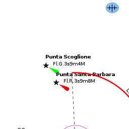
The rocky outcrop of the Argentario Peninsula dominates the flat land to either side and is visible from some distance off. The entrance to Porto Ercole is difficult to spot until it is almost abeam. A small islet immediately S of the headland of Punta Santa Barbara is a useful landmark in the approach. Once past the island (passage inside is possible in calm weather), the fortress of La Rocca and its white lighthouse structure is clearly visible on the headland marking the southern end of the harbour. Entry to the harbour is from NE between a breakwater oriented NNW and the headland at the northern end of the bay.
Entrance
Porto Ercole is a port of entry for Italy. For details see Entrance: Italy.
Berthing
The five pontoons are each operated by private concessions and it is unlikely a yacht in transit will find a berth there during busy periods. Smaller yachts in transit (maximum 12 metres, maximum draft 1.5 metres) can moor towards the outer end of the breakwater, where transit berthing is allowed for up to three days. Larger yachts will have to inquire at one of the pontoons (the centre pontoon has the greatest depth - 3.5 metres) or at the quay at the S side of the harbour (2.0 metres) for a berth. If there is space, the best berths are on the short T at the end of each pontoon, where there is room for 2/3 yachts on laid moorings.
Each of the four pontoons is operated by a different club On the pontoon far to your port when you enter the harbor is Emporio del Sub +39 (0)564 833486
On the pontoon far to starboard is L'Approdo +39 (0)564 830176. We (Amusant 15.8 MY) stayed in mid-September. We were asked for €100 but with our moments hesitation, the price was reduced to €80.
The middle pontoons Albatros and C N V A did not show phone numbers.
Marinas & Yacht Clubs
Anchorages
N of Marina di Cala Galera
Amenities
| Facilities | |
|---|---|
| Water | Water on some of the pontoons (not at every berth) |
| Electricity | Electricity on some of the pontoons (not at every berth)} |
| Toilets | ? |
| Showers | ? |
| Laundry | ? |
| Garbage | Bins near the pontoons |
| Supplies | |
| Fuel | Fuel station on the jetty just N of the pontoons (0730 - 0930 summer only)} |
| Bottled gas | ? |
| Chandlers | ? |
| Services | |
| Repairs | Slipway (500 T). Mobile crane (25 T). Fixed crane (5 T). Engine, electrical and electronic repairs. Wood and fiberglass repairs. Sail repairs. Divers |
| Internet | ? |
| Mobile connectivity | ? |
| Vehicle rentals | ? |
Provisioning
- Supermarket and good provisions shopping in the town
- Fish market on the quay
Eating out
Good restaurants in the town.
Transportation
- The Via Aurelia (E80) runs along the coast at the base of the Argentario Peninsula, 12 kilometres E of Santo Stefano
- Train station at Orbetello, 11 kilometers E of Santo Stefano. Trains to Rome and Pisa
Tourism
The Spanish, who controlled the Peninsula in the 16th century, recognized the strategic significance of the natural harbour of Porto Ercole. Thus the bay is ringed with a series of powerful fortresses, from the fort of La Rocca at the southern end of the bay to the mighty citadel of Forte Filippo at the northern end. Further afield, there are some lovely walks around the Argentario Peninsula with superb views over the sea over to the Isola del Giglio.

Friends
Contact details of "Cruiser's Friends" that can be contacted for local information or assistance.
Forums
List links to discussion threads on partnering forums. (see link for requirements)
Links
- Porto Ercole at the Wikipedia
- Porto Ercole at the Wikivoyage
References & Publications
See Italy.
Comments
We welcome users' contributions to the Wiki. Please click on Comments to view other users' comments, add your own personal experiences or recommend any changes to this page following your visit.
Verified by
Date of member's last visit to Porto Ercole and this page's details validated:
- Data compiled from web research (please update if possible)--Athene of Lymington 14:13, 7 December 2010 (UTC)
If you provide a lot of info and this page is almost complete, change {{Page outline}} to {{Page useable}}.
| This is a usable page of the cruising guide. However, please contribute if you can to help it grow further. Click on Comments to add your personal notes on this page or to discuss its contents. Alternatively, if you feel confident to edit the page, click on the edit tab at the top and enter your changes directly. |
| |
|---|
|
Names: Lighthouse, Athene of Lymington, Dapaz1 |