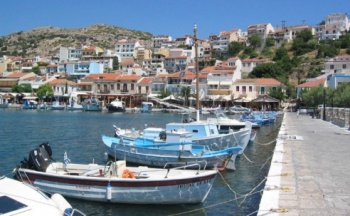
Samos
From CruisersWiki
Samos
Background
Samos (Σάμος) is a lush and sizable island with two tall mountains, Mt. Kerkis (1433 m, 4700 ft.) rising out of the sea on the West side of the island and Mt. Ambelos (1137 m, 3782 ft.) on the North East. Samos is the closest Greek island to Turkey. The Mycale channel, which is 1 nmi wide, separates the two counties, Poseidonio is at the Eastern side of the channel. On the slopes of Mt. Ambelos are large pine forests which produced the best wood for the building of caïques. Lower down there are vineyards which produced the famous since ancient time Samian wine praised by Byron in The isles of Greece.
Samos has a rich history. In antiquity it was a very wealthy island and it was sacred to the goddess Hera. It reached its peak at the 6th century BC under the tyrant Polycrates whose capital was the present day Pythagorion. During his brief reign a large temple to Hera, the Hereon, and one of the engineering marvels of antiquity, the aqueduct of Eupalinos, were constructed. Samos is also the birthplace of the most famous ancient mathematician, Pythagoras, as well as of Aristarchus who first proposed the heliocentric system. A type of war vessel the Samena, was developed in Samos and played a key role in the victory for the Greeks in the naval battle of Mycale against the Persians. The island was pillaged by Mark Anthony in 39 BC.
At the end of the Byzantine era, the island was invaded by the Ottomans in 1453, the population fled and Samos was abandoned. It was re-populated in the 17 century AD. The islanders were very active pirates and Samos was one of the first islands to join the Greek revolution in 1821. The rebels were so successful that after removing all the Ottomans from the island they exported the revolution to Chios. After the massacre of Chios and Psara it was Samos' turn to be invaded. The Samians, aided by the rest of the Greek fleet after many days of fighting defeated soundly the Ottomans on August 6, 1824 in almost the exact spot where the ancient battle of Mycale took place.
Today, Samos has about 45,000 inhabitants. Its capital is Samos. Other towns are Karlovasi, Pythagorion, Marathokampos, and Mytilinii.
Submit details about the sailing/cruising in the area, etc.
Charts
BA 2682 Kolpos Petalion to Nisos Nisiros
BA 1537 Nisides Fournoi with the straits between Nisos Samos and Nisos Ikaria
BA 1568 Ports & anchorages in eastern Agean sea: Limin Karlovasi, Limin Pithagoriou
Imray G32 Southern Sporades and Coast of Turkey
Radio Nets
Also see Cruiser's Nets
Submit details of local radio Nets.
Weather & Climate
The summer weather in Samos is dominated by the meltemi which comes from the NW. Usually it is a light breeze of force 4-5 in the early morning hours but as the day progresses it strengthens to 5-6 by the afternoon and subsides by sunset. However from middle June to mid Septembers you can count for the meltemi to become a gale of force 7-8 and occasionally 9. These gales usually last 3-4 days. From October to mid May the probability is equal for either northerly or southerly winds. Winds of force 10 are not uncommon in the winter months. Violent thunderstorms are also probable by late October to early May.
The channel between Samos and Fourni is notorious for very violent gusts and katabatic winds you can be at least one force point stronger than elsewhere.
Sources for weather forecasts: These are the same for all the Greek waters.
- Athens Observatory gives 3 day (every 6 hrs) detal graphical forecasts for the Greek.
- Poseidon System gives 3 day forecasts for Greek seas from the National Center for Marine Research.
- Weather on Line provides detailed 7 day forecast charts for the Mediterranean, Northern Europe and the Atlantic.
- Greek Meteorological Service (EMY) it includes the Navtex weather bulletins.
- Wind GURU a surfer's site with worldwide wind forecasts.
Details?
Check-in facilities
See each Port/Stop listed below.
Ports and Popular Stops
- Pythagorion (Port of entry)
- Vathi (Port of entry)
- Karlovasi
- Marathokambos
Marinas & Yacht Clubs
Also see each Port/Stop listed above.
Anchorages
List details of all safe anchorages in the area.
- Poseidonio Cove
Description? - Klima
Description? - Nisi
Description? - Zoodochos Pigi
Description? - Mourtia
Description? - Mikri Lakka
Description? - Kerveli
Description? - Psili Amos
Description? - Kolona
Description? - Limnionas Bay
Description?
Offshore Islands
List Islands
Routes/Passages To/From
Popular passages/routes, timing, etc.
Tourism & things to do ashore
List places of interest, tours, eateries, etc.
Marine stores
Submit addresses and contact details of marine related businesses that are of interest to cruisers.
References & Publications
Publications, Guides, etc.
- Heikell, R. Greek Waters Pilot, Imray Laurie and Wilson, Cambridgeshire
- Demetriades A. E. Πορτολάνος Σκαφών Αναψυχής (in Greek), Athens
- Dana Facaros , Greek Islands, Codogan
- Alpha Guide, Desmi Ekdotiki, Athens
Cruiser's Friends
Contact details of "Cruiser's Friends" that can be contacted for local information or assistance.
Forum Discussions
List links to discussion threads on the Cruiser Log Forum
External Links
Links to relevant websites.
Personal Notes
Personal experiences?
.
