Simon's Town
From CruisersWiki
| Simon's Town & False Bay
| |
| | |
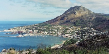
Situated on the Western side of False Bay, Simon's Town owes its existence to Simon van der Stel the Dutch Governor of the Cape Colony from 1677 until 1699. The sheltered bay was discovered and surveyed by the Governor in 1687 and recommended as a safe winter anchorage for the ships of the Dutch East India Company. It was only in 1741 that the Company implemented the Governors recommendation and Simon's Town was proclaimed.
When the British first took the Cape in 1795, their ships also found refuge in Simon's Bay from the severe winter storms that known to cause havoc with ships at anchor in Table Bay.
Simon's Town, with its long association with the naval forces of the Dutch East India Company, the Royal Navy and the South African Navy, has evolved into a unique and quaint village which offers the modern day visitor friendly hospitality and old world charm.
Charts
- S.A.N
- 1017 - Simons Town
- 1016 - False Bay
- BA
- 636 - Table bay to False bay
- 2082 - Cape Columbine to Dager point–Hout bay
Weather
Give local weather conditions or refer to another page (a region or island group) that covers these conditions.
Sources for Weather forecasts:
Passages
Communication
- SA Maritime Net: The South African Maritime Net operates 7 days a week, and provides weather reports from around the coast, and maintains contact with boats off the coast of South Africa and up into the Mozambique channel. There are two regular schedule times as follows:
- 06:30 UTC: Starts on 14316 kHz for 5-10 minutes, and then moves to 7,120 kHz.
- 11:30 UTC: Starts on 14316 kHz for approx. 30 mins and then moves down to 7,120 kHz.
Also see World Cruiser's Nets
Warning: Be aware of the ![]() Roman Rocks [[Simon's Town#Roman Rocks|Roman Rocks]] 34°10.874'S, 018°27.613'E about 1 nM NE of the harbour.
Roman Rocks [[Simon's Town#Roman Rocks|Roman Rocks]] 34°10.874'S, 018°27.613'E about 1 nM NE of the harbour.
Berthing
False Bay Yacht Club (FBYC) lies within the South Africa's primary Naval Port of Simon's Town, which comprises the waters enclosed between the coastline and a line from Oatlands Point Beacon to Roman Rock Light house extended to Elsies Bay Beacon [SAN Chart 1017 refers] and includes the East Dockyard [the harbour] and the West Dockyard. It is under the control of the Flag Officer Commanding Naval Base Simon's Town who has delegated the Naval Harbour Master [NHM] to be the operating authority.
Vessels not registered through FBYC must obtain permission from the NHM to enter the Naval Port. The NHM, callsign "BULLNOSE", VHF Channel 17.
Arrangements may be made in advance through the Secretary of FBYC on telephone : +27 (21) 786 1703.
A courtesy swing mooring is available for visitors to pick up as an emergency overnight mooring in bad weather.
In an EMERGENCY contact John Leslie +27 (82) 351 8099.
Marinas & Yacht Clubs
False Bay Yacht Club
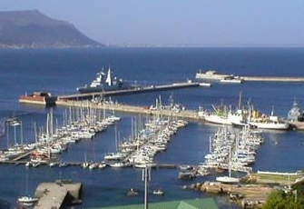
he False Bay Yacht Club was founded in 1958 and moved into its present modern clubhouse in 1984. The club is situated centrally in Simon's Town and within walking distance of most amenities. Visitors are welcome and can be accommodated on either swing moorings or the walk-on marinas. False Bay Yacht Club is becoming a cruisers' favourite due to the picturesque setting and very friendly members. False Bay is an ideal sailing Bay, although beware of the summer South Easters. © copyright FBYC.
Total of 220 berths Maximum length: 15 metres. Five visitors berths can accommodate large boats with a maximum weight of 18 tons & 22 m LOA. Also there are swinging moorings. Full service marina with clubhouse. Fresh water & Electricity (220 V, 50 Hz. 24 hour CCTV security. Hardstanding area with a capacity of 10 - 15 boats. Sling-lift carrier with a lifting capacity of 16 tons. Chandlery and good range of repair services, including sails.
- [email protected]; Tel: +27 (21) 786 3853; Fax: +27 (21) 786-3925; VHF channel 16
- Address: King George’s Way, Simon’s Town, 7975, South Africa
- Hours:
- Prices: For the latest prices see [XXX Price Listing]
Anchorages
You may be able to anchor off in Simon's Bay.
Amenities
| Facilities | |
|---|---|
| Water | In the Yacht Club |
| Electricity | In the Yacht Club |
| Toilets | In the Yacht Club |
| Showers | In the Yacht Club |
| Laundry | ? |
| Garbage | Bins in the Yacht Club |
| Supplies | |
| Fuel | ? |
| Bottled gas | ? |
| Chandlers | In the Yacht Club |
| Services | |
| Repairs | In the Yacht Club |
| Internet | ? |
| Mobile connectivity | ? |
| Vehicle rentals | ? |
Provisioning
Give the names and locations of supermarkets, grocery stores, bakeries, etc.
Eating out
Give the name of recommended restaurants, tavernas, pastry stores, etc.
Transportation
List transportation (local and/or international.)
Tourism
History
Give a short history of the port.
Places to Visit
List places of interest, tours, etc.
Friends
Contact details of "Cruiser's Friends" that can be contacted for local information or assistance.
Forums
List links to discussion threads on partnering forums. (see link for requirements)
Links
- Simon's Town at the Wikipedia
- Simon's Town at the Wikivoyage
- Noonsite
References
See South Africa.
Comments
We welcome users' contributions to the Wiki. Please click on Comments to view other users' comments, add your own personal experiences or recommend any changes to this page following your visit.
Verified by
Date of member's last visit to Simon's Town and this page's details validated:
If you provide a lot of info and this page is almost complete, change {{Page outline}} to {{Page useable}}.
| This page has an outline in place but needs completing. Please contribute if you can to help it grow further. Click on Comments to suggest further content or alternatively, if you feel confident to edit this page, click on the edit tab at the top and enter your changes directly. |
| |
|---|
|
Names: Lighthouse |

