Skarda
From CruisersWiki
m (Text replace - "==Weather== Diurnal winds among the islands are mostly moderate during the summer months, predominantly from NW and rarely exceeding force 4/5, although gusting is common in narrow channels between islands and on the lee side of headlands.) |
m (Bot: Automated text replacement (-{{IsPartOf|Mediterranean|Adriatic Sea|Croatia}} +{{IsPartOf|Mediterranean|Adriatic Sea|Croatia|Kvarner}})) |
||
| Line 1: | Line 1: | ||
| - | {{IsPartOf|Mediterranean|Adriatic Sea|Croatia}} | + | {{IsPartOf|Mediterranean|Adriatic Sea|Croatia|Kvarner}} |
{{TOC block}} | {{TOC block}} | ||
An online cruising guide for yachts sailing to Skarda Island in Croatia. | An online cruising guide for yachts sailing to Skarda Island in Croatia. | ||
Revision as of 12:30, 2 September 2018
An online cruising guide for yachts sailing to Skarda Island in Croatia.
| Skarda
| |
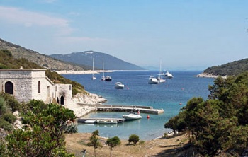
Skarda Island lies off the mainland coast of Croatia, two miles SE of the island of Premuda and half a mile W of the island of Ist. Under two square miles in size and relatively low-lying, the island supports a summer population of barely 20 inhabitants, swelled during the summer by holiday apartment occupants and day trippers from the mainland. There are just two anchorages on the island, the open and rather exposed bay of U. Skarda on the N coast of the island and the sheltered inlet of U. Griparica at the S end. The latter is equipped with mooring buoys for visiting yachts and a restaurant which opens in July and August only .
Charts
- British Admiralty
- 515
- Croatian charts
- MK 11
- Imray
- M25
Weather
See Croatia.
Passages
See Croatia.
Islands
Communication
Add here VHF channel for coastguard, harbor masters. etc.
Also see World Cruiser's Nets
Add any navigation notes such approaches, dangers etc here. If this section does not apply remove it.
Berthing
There are just two berthing options for yachts visiting the island, the anchorages of U. Skarda and U. Griparica. For details see below under Anchorages.
Ports
None.
Marinas & Yacht Clubs
None.
Anchorages
Note: U. (short for Uvala) = cove. Click on the co-ordinates below for a simple map.
U. Skarda
U. Griparica
Facilities
Water
N/A (Not Available).
Electricity
N/A.
Toilets
?
Showers
?
Laundry
None.
Garbage
?
Supplies
Fuel
No fuel.
Cooking gas
None.
Chandlers
None.
Services
Repairs
None.
Internet
N/A.
Mobile connectivity
Is there mobile telephone signal such as G4, G3, GPRS in the island? How strong is the signal? Are there any blind spots?
Vehicle Rentals
None.
Provisioning
N/A.
Transportation
N/A.
Eating out
- Please specify POI name
 [[Skarda# | ]] 44°16.687'N, 014°42.964'E Seasonal restaurant.
Tourism
Places to Visit
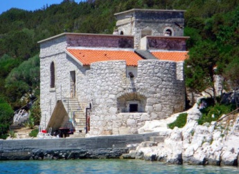
There is little to do on the island. Most yachts use the anchorages as a lunch stop, although U. Griparica is a popular overnight stop. There is an interesting ‘fortified house’ at the head of U. Griparica, now converted to holiday apartments, with a cannon pointing down the inlet.
Friends
Contact details of "Cruiser's Friends" that can be contacted for local information or assistance.
Forums
List links to discussion threads on partnering forums. (see link for requirements)
Links
- Skarda at the Wikipedia
- List of all Croatian marinas
- List of government-owned ACI marinas
- Croatian National Tourist Board
- Find Croatia travel guide
- Wikipedia - Croatia
References
See Croatia.
Comments
We welcome users' contributions to the Wiki. Please click on Comments to view other users' comments, add your own personal experiences or recommend any changes to this page following your visit.
Verified by
Date of member's last visit to Skarda and this page's details validated:
- July 2004 --Athene of Lymington 15:04, 21 April 2012 (BST)
| This is a usable page of the cruising guide. However, please contribute if you can to help it grow further. Click on Comments to add your personal notes on this page or to discuss its contents. Alternatively, if you feel confident to edit the page, click on the edit tab at the top and enter your changes directly. |
| |
|---|
|
Names: Athene of Lymington |

