User:Istioploos/Sandbox
From CruisersWiki
m (Bot: Automated text replacement (-example +test)) |
Istioploos (Talk | contribs) |
||
| Line 1: | Line 1: | ||
| - | + | {{IsPartOf|Mediterranean|Adriatic Sea|Croatia|Central Dalmatia|Brač}} | |
| + | {{TOC block}} | ||
| - | + | {{Infobox | |
| - | {{ | + | | lat=43.3275|lon=16.44893 |
| - | | | + | | name= Milna |
| - | | | + | | zoom= 14 |
| - | | | + | | chartlet=y |
| - | | | + | | image= MilnaAerial.jpg |
| - | | | + | | imagetext= Milna inlet from SE |
| - | | | + | | summary= The bay of [[Milna]] is situated at the SW tip of the island of [[Brač]] in [[Croatia]], a mile E of the narrow channel that separates the island from its neighbour, [[Šolta]] Island. |
| - | | | + | |
| - | + | ||
| - | + | It is a very busy harbour during the summer, hosting several hundred yachts at its two marinas of [[Marina Milna]] and [[Marina Vlaska]] and its town quay to the north of the prominent church at the head of the inlet. As the most sheltered natural harbour on the island, Milna inlet has been in use since Roman times and was subsequently adopted as a naval base by Venetian, Napoleonic and Russian fleets. The harbour has good all-round shelter, although strong W winds cause some swell on the town quay. | |
| - | + | | notes= | |
| + | | news= | ||
| + | }} | ||
| - | + | ==Charts== | |
| - | + | ''See [[Central Dalmatia#Charts|Central Dalmatia]]''. | |
| - | + | ||
| - | + | ||
| - | + | ==Weather== | |
| - | + | ''See [[Croatia#Weather|Croatia]]''. | |
| - | + | ||
| - | + | ||
| - | [[ | + | ==Passages== |
| + | ''See [[Croatia#Passages|Croatia]]''. | ||
| - | + | ==Communication== | |
| - | * | + | {{Green|Add here VHF channel for the coastguard, harbor masters. etc.}} |
| - | * | + | * |
| + | * | ||
| - | + | ''Also see [[HF_Radio|Cruiser's Nets]]'' | |
| - | * {{ | + | |
| - | * {{ | + | ==Navigation== |
| - | + | The approach to [[Milna]] has no dangers. There are three branches of the inlet. The first inlet to port on entry contains the small marina of [[Marina Vlaska]]; the top of the inlet branches into two, the part to the port being shallow and containing local boat moorings only, the part to starboard containing [[Marina Milna]]. Straight ahead is the town quay, part of which (from the red port marker southwards) is operated by Marina Milna, the remainder being ‘public quay’. Depths in the entrance are over 20.0 metres; in the Marina Vlaska inlet 4.0 - 8.0 metres; in the Marina Milna inlet 3.0 - 4.0 metres and along the town quay 2.0 - 3.0 metres. | |
| + | |||
| + | ==Entrance== | ||
| + | [[Split]] is the nearest all-year round port of entry. During the summer, [[Hvar]], [[Vis]] and, if arriving from N, [[Primošten]] on the mainland are also ports of entry. | ||
| + | |||
| + | ==Berthing== | ||
| + | {{poi | ||
| + | | type= harbour | ||
| + | | name=Town quay | ||
| + | | lat=43.3272|lon=16.44779 |zoom=16 | ||
| + | | url= | ||
| + | | image= MilnaQuay.jpg | ||
| + | | imagetext= Yachts moored on Milna town quay | ||
| + | | text=The section of the town quay to the S of the red light structure is part of [[Marina Milna]]. N of the light structure, however, is public quay and yachts may moor here bows or stern-to using their anchors in depths of 3.0 metres. At quiet times or for short periods it may be possible to lie alongside. Shelter here is good, although strong W winds cause a swell on the quay. There are no facilities on this section of the quay. | ||
| + | }} | ||
| + | |||
| + | {{poi | ||
| + | | type= harbour | ||
| + | | name=N quay | ||
| + | | lat=43.32854|lon=16.44112|zoom=16 | ||
| + | | url= | ||
| + | | text=E of the [[Marina Vlaška]] is likely possible to moor alongside. | ||
| + | }} | ||
| + | |||
| + | {{poi | ||
| + | | type= harbour | ||
| + | | name=S pontoon | ||
| + | | lat=43.32731|lon=16.44147|zoom=16 | ||
| + | | url= | ||
| + | | text=Some yachts were noticed to moor at the pontoon SE of the Marina Vlaška across the bay. The pontoon presumably used to belong to a hotel ashore, but it appears to be unmanned. | ||
| + | }} | ||
| + | |||
| + | ===Marinas & Yacht Clubs=== | ||
| + | * {{dest|Marina Milna|m}} – the ACI-operated marina of [[Marina Milna]] offers 189 berths for yachts up to 25 metres in depths of up to 7.0 metres. | ||
| + | * {{dest|Marina Vlaška|m}} – offers 71 berths for yachts up to 20 metres in depths of up to 8.0 metres. | ||
| + | |||
| + | {{poi | ||
| + | | type=marina | ||
| + | | name=Yacht Club Milna | ||
| + | | lat=43.32712|lon=16.44562 | ||
| + | | url=http://www.yachtclubmilna.com | ||
| + | | text=is a small marina run by the ''Nautički centre Milna'' (tel. {{phone|385| 91|4000 487}}). It's located at the S quay at the section of inlet from the fuel berth to starboard on entry as far as the ACI marina boatyard and reception pier. It features 45 berths. However, this position is subject to considerable wash from the ferries which run twice daily to Split on most weekdays. Shelter here is good - apart from the ferry wash - but strong W winds cause a swell. | ||
| + | }} | ||
| + | |||
| + | ==Anchorages== | ||
| + | {{poi | ||
| + | | type=anchorage | ||
| + | | name=N cove | ||
| + | | lat=43.32809|lon=16.44698 |zoom=16 | ||
| + | | url= | ||
| + | | text= | ||
| + | It is possible to anchor with care in the N cove at the head of Milna inlet, clear of the local boat moorings and the fairway to the town quay. Depths here are 2.0 - 3.0 metres only, so this anchorage will not suit larger yachts. Holding is good in sand and weed. | ||
| + | }} | ||
| - | + | In winds from W and S, there are several quiet coves along the S shore of the island just outside Milna inlet where yachts can anchor, with a line ashore if necessary. The coves are unsuitable with anything N in the wind. | |
Revision as of 19:23, 12 April 2019
| Milna
| |
| | |
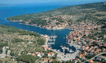
The bay of Milna is situated at the SW tip of the island of Brač in Croatia, a mile E of the narrow channel that separates the island from its neighbour, Šolta Island.
It is a very busy harbour during the summer, hosting several hundred yachts at its two marinas of Marina Milna and Marina Vlaska and its town quay to the north of the prominent church at the head of the inlet. As the most sheltered natural harbour on the island, Milna inlet has been in use since Roman times and was subsequently adopted as a naval base by Venetian, Napoleonic and Russian fleets. The harbour has good all-round shelter, although strong W winds cause some swell on the town quay.
Charts
See Central Dalmatia.
Weather
See Croatia.
Passages
See Croatia.
Communication
Add here VHF channel for the coastguard, harbor masters. etc.
Also see Cruiser's Nets
The approach to Milna has no dangers. There are three branches of the inlet. The first inlet to port on entry contains the small marina of Marina Vlaska; the top of the inlet branches into two, the part to the port being shallow and containing local boat moorings only, the part to starboard containing Marina Milna. Straight ahead is the town quay, part of which (from the red port marker southwards) is operated by Marina Milna, the remainder being ‘public quay’. Depths in the entrance are over 20.0 metres; in the Marina Vlaska inlet 4.0 - 8.0 metres; in the Marina Milna inlet 3.0 - 4.0 metres and along the town quay 2.0 - 3.0 metres.
Entrance
Split is the nearest all-year round port of entry. During the summer, Hvar, Vis and, if arriving from N, Primošten on the mainland are also ports of entry.
Berthing
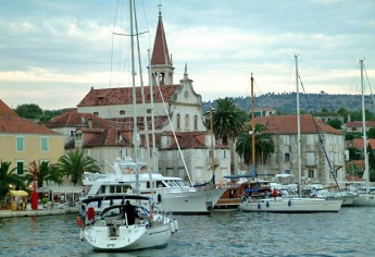
Town quay
N quay
S pontoon
Marinas & Yacht Clubs
- Marina Milna |– the ACI-operated marina of Marina Milna offers 189 berths for yachts up to 25 metres in depths of up to 7.0 metres.
 – marina |
 - Marina Vlaška |– offers 71 berths for yachts up to 20 metres in depths of up to 8.0 metres.
 – marina |
Yacht Club Milna
Anchorages
N cove
In winds from W and S, there are several quiet coves along the S shore of the island just outside Milna inlet where yachts can anchor, with a line ashore if necessary. The coves are unsuitable with anything N in the wind.

