Ventotene
From CruisersWiki
| Ventotene
| |
| | |
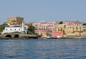
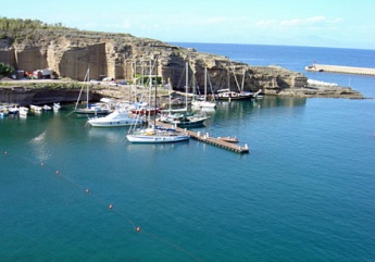
The island of Ventotene, one of the so-called Pontine Islands, lies off the west coast of Italy about 21 miles SE of Ponza and 18 miles west of Ischia. The remains of an extinct volcano, the island was known as Pandateria during the Roman era and was a popular spot for the Roman emperors to exile (and, frequently, murder) errant female members of their extended families. The Romans carved a harbour, now known as the Porto Vecchio, out of the volcanic tufa. The harbour is supplemented today by a new harbour just north, known as Porto Nuovo or Cala Rossano. The old harbour is shallow but you can enter with a draught up to about 2 meters and length up to 12 meters, watching at the entrance for a rock. Inside you have to go to the pier with the bow. You can find water and electricity. A pontoon has been installed in the new harbour with space for around 20 yachts on laid moorings. The Isola di Ventotene Yacht Club (IVYC) has about 50 places between the old and new harbours. Prices are around 10 € per meter (8/2012).
Charts
- British Admiralty
- 1911 - I. del Giglio to I. d’Ischia
- Italian
- 914
Weather
Prevailing winds are from W or NW, in which conditions shelter is reasonably good in both of the island’s harbours. However, strong northerly winds cause a surge in the new harbour which could be dangerous if near gale force. In spite of its east-facing entrance, the old harbour is also dangerous in very strong conditions.
Sources for weather forecasts:
- There is a continuous (computerized voice) weather forecast on VHF 68 - first in Italian and then followed with an English translation
- The same forecast is given in Italian and English on VHF coastal stations following a notification on channel 16
- Navtex weather forecasts are broadcast from stations at Roma, Cagliari (Sardinia) and Augusta (Sicily)
Passages
See Mediterranean.*
Islands
- Santo Stefano - (one mile due east) is a former prison island. There are no suitable anchorages
Communication
Add here VHF channel for coastguard, harbor masters. etc.
Also see World Cruiser's Nets.
Both harbours lie at the NE end of the island. There are no dangers in the approaches. However, there are shallow rocks in the entrance to the old harbour which reduce the depth in places to only 1.6 metres. With local knowledge, vessels of up to 1.8 metres can enter.
Berthing
Harbourmaster in old harbour. No customs on the island.
Ports
Porto Nuovo
Porto Vecchio
Marinas & Yacht Clubs
None.
Anchorages
In settled weather, it is possible to anchor in the bay to the south of the Port Vecchio. Depths are 8.0 - 12.0 metres. Hoding is reasonable in sand and rock.
Amenities
| Facilities | |
|---|---|
| Water | Water points in both harbours. Water is delivered by ship, so is scarce in the summer months |
| Electricity | Electricity points in both harbours |
| Toilets | N/A (Not Available). |
| Showers | N/A |
| Laundry | N/A |
| Garbage | Bins at both harbours |
| Supplies | |
| Fuel | Fuel on the quay in Porto Nuovo |
| Bottled gas | N/A |
| Chandlers | None |
| Services | |
| Repairs | Very limited. There is a slipway and mobile crane in Porto Nuovo |
| Internet | ? |
| Mobile connectivity | ? |
| Vehicle rentals | N/A |
Provisioning
Reasonable provisions in the village.
Eating out
Restaurants and pizzerias in the village.
Transportation
Ferry and hydrofoil services to Anzio and Formia. Ferries to Ischia (summer only).
Tourism
The old Roman harbour is an impressive piece of ancient engineering and is well worth a visit (assuming you don’t take your life in your hands by berthing there). The village is also quite picturesque, with pastel-coloured fishermen’s houses, seemingly built into the solid rock, climbing up from the port. There are also remains of Roman villas and aqueducts dotted around the island.
Friends
Contact details of "Cruiser's Friends" that can be contacted for local information or assistance.
Forums
List links to discussion threads on partnering forums. (see link for requirements)
Links
References & Publications
See Italy.
Comments
We welcome users' contributions to the Wiki. Please click on Comments to view other users' comments, add your own personal experiences or recommend any changes to this page following your visit.
Verified by
Date of member's last visit to Ventotene and this page's details validated:
- July 2003 --Athene of Lymington
- July 2013 --Sephina
| This is a usable page of the cruising guide. However, please contribute if you can to help it grow further. Click on Comments to add your personal notes on this page or to discuss its contents. Alternatively, if you feel confident to edit the page, click on the edit tab at the top and enter your changes directly. |
| |
|---|
|
Names: Lighthouse, Athene of Lymington |

