Whitsunday Island
From CruisersWiki
Istioploos (Talk | contribs) m (Reverted edits by Riley Huntley (talk) to last revision by Haiqu) |
Peter McHugh (Talk | contribs) (Some content added) |
||
| Line 1: | Line 1: | ||
== Whitsunday Island Cruising Guide == | == Whitsunday Island Cruising Guide == | ||
An online cruising guide for yachts sailing to Whitsunday Island | An online cruising guide for yachts sailing to Whitsunday Island | ||
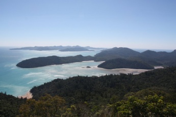
| - | [[Image: | + | [[Image:Whitsunday_Island_Queensland.jpg|345px|thumb|right|'''Looking north from Whitsunday Peak ''' <br />''Click for larger view'']] |
====Overview==== | ====Overview==== | ||
| - | + | Whitsunday Island is the largest of the Whitsunday Islands. It has a variety of good anchorages, some of which are stunningly spectacular. There is a small number of walks on the island and large areas of untouched bushland. The island is entirely National Park and there are no facilities on the island. | |
| - | |||
{| class="infobox bordered" style="width: 29em; text-align: left; font-size: 85%;" | {| class="infobox bordered" style="width: 29em; text-align: left; font-size: 85%;" | ||
|- | |- | ||
| Line 20: | Line 19: | ||
! <center>[[image:Chart_icon.png]]</center> | ! <center>[[image:Chart_icon.png]]</center> | ||
| [ Local chartlet] | | [ Local chartlet] | ||
| + | |- | ||
| + | | colspan="2" style="text-align:center; font-size: smaller;" | <googlemap lat="-20.23514" lon="148.96843" zoom="11" width="350" height="335"></googlemap> | ||
|} | |} | ||
{{TOCleft}} | {{TOCleft}} | ||
| + | |||
====Cruising the region==== | ====Cruising the region==== | ||
| - | + | Whitsunday Island is the largest of the Whitsunday group. It is about 12 miles from the tourism centre of [[Airlie Beach]] and only a mile or so north of the major tourist resort and airport on Hamilton Island. Nearby Hook Island provides good alternative anchorages depending on circumstances. | |
==Charts== | ==Charts== | ||
| Line 41: | Line 43: | ||
==Approach and Navigation== | ==Approach and Navigation== | ||
| - | |||
| - | == | + | ===Anchorages=== |
| - | + | ||
| - | == | + | ====Cid Harbour==== |
| - | === | + | |
| - | + | ||
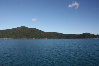
| - | + | [[Image:Cid Harbour Whitsunday Island.jpg|345px|thumb|right|'''Cid Harbour''' <br />''Click for larger view'']] | |
| - | + | Cid Harbour is large and very popular anchorage on the western side of Whitsunday Island. The area is relatively sheltered from the prevailing SEly winds and generally free from swell. The anchorage can accommodate a very large number of boats and is popular with charter boats. It is not uncommon to find 50 boats overnighting here. There is a good landing spot at Sawmill Beach (site of an old sawmill) with walking tracks to Whitsunday Peak and to Dugong Beach. Expect to see turtles and dugongs in the anchorage. | |
| - | + | The water is not clear, so care is required in anchoring, especially at the southern end where a patch of coral extends east from Hughes Point. | |
| + | There are no mooring buoys in Cid Harbour and none of the anchoring restrictions that apply in more sensitive areas. Expect a mud bottom and 4 - 5 metres of water. | ||
| - | + | When approaching from the south, especially from Hamilton Island, Hunt Channel, between Whitsunday Island and Cid Island is commonly used. There is a strong tidal flow in this passage. | |
| - | + | ||
| - | + | ||
| - | == | + | ====Mays Bay==== |
| - | + | ||
| - | ==== | + | |
| - | + | ||
| - | + | ||
| - | ==== | + | Mays Bay is a small area just north of Cid Harbour. It is a comfortable anchorage in SEly conditions and tends to attract few boats. It may provide some solitude if Cid Harbour is excessively crowded. |
| - | + | ||
| + | ====Tongue Bay==== | ||
| + | |||
| + | Tongue Bay lies at the northern end of Whitehaven Beach and offers a much more sheltered anchorage if any southerly breeze is blowing. There are mooring buoys in the bay, but there is also a large area available for anchoring in reasonable depths. The bay is very popular with tour boats who take their passengers ashore to visit the Hill Inlet lookout. | ||
| + | Note that the landing beach, which gives access to the Hill Inlet Lookout, is fringed by a wide area of reef that dries at low tide. Keep an eye on the tide to ensure that you are not trapped ashore by a falling tide. | ||
| + | |||
| + | ====Hill Inlet==== | ||
| + | |||
| + | Hill Inlet is accessible to very shoal draft boats. The inlet meanders considerably and is very tidal. It is strongly recommended that you take a good look at the area before attempting an entrance. Neither the entrance nor the channel are marked in any way | ||
| + | |||
| + | ====Whitehaven Beach==== | ||
| + | |||
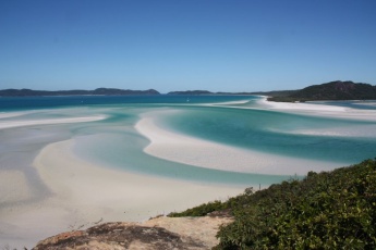
| + | [[Image:Whitehaven Beach Whitsunday Island.jpg|345px|thumb|right|'''Hill Inlet and Whitehaven Beach''' <br />''Click for larger view'']] | ||
| + | Whitehaven Beach is a great anchorage in good conditions, but can be uncomfortable in brisk South Easterlies. The southern end of the beach is very popular, with a large number of day tripper boats arriving each day, not to mention seaplanes and helicopters. Don't expect solitude. Anchor in shallow water close to the beach on white sand. | ||
| + | Note that if you approach or leave Whitehaven via Solway Passage, care should be taken to avoid peak tide flows. A strong south flowing tidal stream, combined with brisk Trade Wind conditions, can produce very nasty conditions in the Passage. Whirlpools and steep standing waves are not uncommon. | ||
| + | |||
| + | ====Chance Bay==== | ||
| + | |||
| + | Chance Bay is only usable in calm or northerly conditions. Care needs to be taken to avoid the extensive reefs in the bay. | ||
| + | |||
| + | ====Gulnare Inlet==== | ||
| + | |||
| + | [[Image:Gulnare_Inlet_Whitsunday_Island.jpg|345px|thumb|right|'''Gulnare Inlet as seen from Whitsunday Peak''' <br />''Click for larger view'']] | ||
| + | Gulnare Inlet lies on the southern side of Whitsunday Island. The entrance is relatively shallow and care is required. | ||
====Fuel, Water, & Electricity==== | ====Fuel, Water, & Electricity==== | ||
; Fuel | ; Fuel | ||
| - | : | + | : Either Hamilton Island, Airlie Beach or Shute harbour. |
; Water | ; Water | ||
| - | : | + | : Either Hamilton Island, Airlie Beach or Shute harbour. |
; Electricity | ; Electricity | ||
| - | : | + | : Not on Whitsunday Island |
| - | + | ||
| - | + | ||
| - | + | ||
| - | + | ||
==Things to do Ashore== | ==Things to do Ashore== | ||
===Tourism=== | ===Tourism=== | ||
| - | |||
| - | |||
| - | + | * Climb Whitsunday Peak from Sawmill Beach for stunning views that encompass most of the Whitsundays. An energetic climb, but the track is good. Look for the ruins of the sawmill. | |
| - | * | + | * Walk to Dugong Beach from Sawmill Beach. Look for the Hoop Pines that were the basis for the old sawmill. There are basic camping facilities at Dugong Beach. |
| - | + | * Walk from Tongue Bay to the Hill Inlet lookout. This very popular walk provides a great view of Hill Inlet and the beautiful Whitehaven Beach. It is best done near high tide as the reef can be exposed by the falling tide, making the return dinghy trip difficult. Explore Hill Inlet and look for the stingrays in the shallow water (don't tread on them!!). | |
| - | + | * Enjoy a stroll on Whitehaven Beach. Despite the huge daily influx of day trippers, the beach is long enough for you to find a secluded piece if you want it. | |
| - | * | + | * Walk from Whitehaven Beach across to Chance Bay. This pleasant stroll through the bush takes you to the south facing Chance Bay. Despite the very large number of people on Whitehaven Beach, very few do this walk and Chance Bay is often deserted. Look for brush turkeys along the way and keep an eye out for the enormous mounds that they build. |
| - | + | ||
| - | + | ||
| - | + | ||
| - | + | ||
| - | + | ||
| - | * | + | |
| - | + | ||
| - | + | ||
| - | * | + | |
===Garbage Disposal=== | ===Garbage Disposal=== | ||
| - | + | Take your rubbish back to Airlie Beach or to Hamilton Island. | |
| - | + | ||
| - | + | ||
| - | + | ||
| - | + | ||
==Routes/Passages To/From== | ==Routes/Passages To/From== | ||
| Line 132: | Line 129: | ||
====''Last Visited & Details Checked (and updated here)''==== | ====''Last Visited & Details Checked (and updated here)''==== | ||
''Date of member's visit to this Port/Stop & this page's details validated'': | ''Date of member's visit to this Port/Stop & this page's details validated'': | ||
| - | * | + | * [[User:Peter McHugh|Pedro]] - August 2012 |
| - | + | ||
{{Guide1}} | {{Guide1}} | ||
| Line 143: | Line 139: | ||
|- | |- | ||
|style="color:#000;"|<small> | |style="color:#000;"|<small> | ||
| - | Names: | + | Names: [[User:Peter McHugh|Pedro]] |
</small> | </small> | ||
|} | |} | ||
Revision as of 11:06, 27 February 2013
Whitsunday Island Cruising Guide
An online cruising guide for yachts sailing to Whitsunday Island
Overview
Whitsunday Island is the largest of the Whitsunday Islands. It has a variety of good anchorages, some of which are stunningly spectacular. There is a small number of walks on the island and large areas of untouched bushland. The island is entirely National Park and there are no facilities on the island.
| | |
| | DD°M.M′N/S, DD°M.M′E/W |
|---|---|
| | [ Photo gallery] |
| | [ Local chartlet] |
Cruising the region
Whitsunday Island is the largest of the Whitsunday group. It is about 12 miles from the tourism centre of Airlie Beach and only a mile or so north of the major tourist resort and airport on Hamilton Island. Nearby Hook Island provides good alternative anchorages depending on circumstances.
Charts
Submit the chart details that are required for safe navigation.
- Chart Source
- Chart Number
Radio Nets
Also see Cruiser's Nets
Weather
Local weather conditions?
Sources for Weather forecasts:
Anchorages
Cid Harbour
Cid Harbour is large and very popular anchorage on the western side of Whitsunday Island. The area is relatively sheltered from the prevailing SEly winds and generally free from swell. The anchorage can accommodate a very large number of boats and is popular with charter boats. It is not uncommon to find 50 boats overnighting here. There is a good landing spot at Sawmill Beach (site of an old sawmill) with walking tracks to Whitsunday Peak and to Dugong Beach. Expect to see turtles and dugongs in the anchorage. The water is not clear, so care is required in anchoring, especially at the southern end where a patch of coral extends east from Hughes Point. There are no mooring buoys in Cid Harbour and none of the anchoring restrictions that apply in more sensitive areas. Expect a mud bottom and 4 - 5 metres of water.
When approaching from the south, especially from Hamilton Island, Hunt Channel, between Whitsunday Island and Cid Island is commonly used. There is a strong tidal flow in this passage.
Mays Bay
Mays Bay is a small area just north of Cid Harbour. It is a comfortable anchorage in SEly conditions and tends to attract few boats. It may provide some solitude if Cid Harbour is excessively crowded.
Tongue Bay
Tongue Bay lies at the northern end of Whitehaven Beach and offers a much more sheltered anchorage if any southerly breeze is blowing. There are mooring buoys in the bay, but there is also a large area available for anchoring in reasonable depths. The bay is very popular with tour boats who take their passengers ashore to visit the Hill Inlet lookout. Note that the landing beach, which gives access to the Hill Inlet Lookout, is fringed by a wide area of reef that dries at low tide. Keep an eye on the tide to ensure that you are not trapped ashore by a falling tide.
Hill Inlet
Hill Inlet is accessible to very shoal draft boats. The inlet meanders considerably and is very tidal. It is strongly recommended that you take a good look at the area before attempting an entrance. Neither the entrance nor the channel are marked in any way
Whitehaven Beach
Whitehaven Beach is a great anchorage in good conditions, but can be uncomfortable in brisk South Easterlies. The southern end of the beach is very popular, with a large number of day tripper boats arriving each day, not to mention seaplanes and helicopters. Don't expect solitude. Anchor in shallow water close to the beach on white sand. Note that if you approach or leave Whitehaven via Solway Passage, care should be taken to avoid peak tide flows. A strong south flowing tidal stream, combined with brisk Trade Wind conditions, can produce very nasty conditions in the Passage. Whirlpools and steep standing waves are not uncommon.
Chance Bay
Chance Bay is only usable in calm or northerly conditions. Care needs to be taken to avoid the extensive reefs in the bay.
Gulnare Inlet
Gulnare Inlet lies on the southern side of Whitsunday Island. The entrance is relatively shallow and care is required.
Fuel, Water, & Electricity
- Fuel
- Either Hamilton Island, Airlie Beach or Shute harbour.
- Water
- Either Hamilton Island, Airlie Beach or Shute harbour.
- Electricity
- Not on Whitsunday Island
Things to do Ashore
Tourism
- Climb Whitsunday Peak from Sawmill Beach for stunning views that encompass most of the Whitsundays. An energetic climb, but the track is good. Look for the ruins of the sawmill.
- Walk to Dugong Beach from Sawmill Beach. Look for the Hoop Pines that were the basis for the old sawmill. There are basic camping facilities at Dugong Beach.
- Walk from Tongue Bay to the Hill Inlet lookout. This very popular walk provides a great view of Hill Inlet and the beautiful Whitehaven Beach. It is best done near high tide as the reef can be exposed by the falling tide, making the return dinghy trip difficult. Explore Hill Inlet and look for the stingrays in the shallow water (don't tread on them!!).
- Enjoy a stroll on Whitehaven Beach. Despite the huge daily influx of day trippers, the beach is long enough for you to find a secluded piece if you want it.
- Walk from Whitehaven Beach across to Chance Bay. This pleasant stroll through the bush takes you to the south facing Chance Bay. Despite the very large number of people on Whitehaven Beach, very few do this walk and Chance Bay is often deserted. Look for brush turkeys along the way and keep an eye out for the enormous mounds that they build.
Garbage Disposal
Take your rubbish back to Airlie Beach or to Hamilton Island.
Routes/Passages To/From
Popular passages/routes, timing, etc.
Cruiser's Friends
Contact details of "Cruiser's Friends" that can be contacted for local information or assistance.
Forum Discussions
List links to discussion threads on partnering forums. (see link for requirements)
External Links
Links to relevant websites.
References & Publications
Publications, Guides, etc.
Personal Notes
Personal experiences?
Last Visited & Details Checked (and updated here)
Date of member's visit to this Port/Stop & this page's details validated:
- Pedro - August 2012
|
|---|
|
Names: Pedro |
| |
|---|
| | HOMEPAGE | Wiki Contents | Queensland | Whitsunday Island | |


