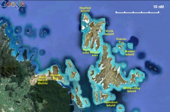
Whitsundays
From CruisersWiki
Istioploos (Talk | contribs) (Under construction) |
Istioploos (Talk | contribs) (Updated) |
||
| Line 9: | Line 9: | ||
An online cruising guide for yachts sailing around the Whitsundays Islands.<br /> | An online cruising guide for yachts sailing around the Whitsundays Islands.<br /> | ||
''See also [[Whitsunday Passage]]'' | ''See also [[Whitsunday Passage]]'' | ||
| + | {{TOCleft}} | ||
====Overview==== | ====Overview==== | ||
| Line 17: | Line 18: | ||
The name ''Whitsunday'' is derived from [http://en.wikipedia.org/wiki/James_Cook Captain Cook’s] [[Whitsunday Passage]] which is believed that he discovered on the day of the [http://en.wikipedia.org/wiki/Whit_Sunday Pentecost] also known as Whit Sunday. | The name ''Whitsunday'' is derived from [http://en.wikipedia.org/wiki/James_Cook Captain Cook’s] [[Whitsunday Passage]] which is believed that he discovered on the day of the [http://en.wikipedia.org/wiki/Whit_Sunday Pentecost] also known as Whit Sunday. | ||
| - | |||
====Cruising the region==== | ====Cruising the region==== | ||
The Whitsunday Islands are an almost idyllic cruising ground. There are numerous islands with lovely protected beaches and anchorages and fantastic coral reefs teaming with tropical fish. Most of the area is part of the [http://en.wikipedia.org/wiki/Whitsunday_Islands_National_Park Whitsunday Islands National Park] and several restrictions are applied. There are areas where anchoring is restricted, to protect the coral, but there are usually mooring buoys which can be used for 2 hours during the day and for an overnight after 4 PM. For information refer to the indispensable [http://www.windward.com.au/ 100 Magic Miles] by David Colfelt. | The Whitsunday Islands are an almost idyllic cruising ground. There are numerous islands with lovely protected beaches and anchorages and fantastic coral reefs teaming with tropical fish. Most of the area is part of the [http://en.wikipedia.org/wiki/Whitsunday_Islands_National_Park Whitsunday Islands National Park] and several restrictions are applied. There are areas where anchoring is restricted, to protect the coral, but there are usually mooring buoys which can be used for 2 hours during the day and for an overnight after 4 PM. For information refer to the indispensable [http://www.windward.com.au/ 100 Magic Miles] by David Colfelt. | ||
| - | + | <div style="clear: both;"></div> | |
====Local Dangers==== | ====Local Dangers==== | ||
| + | {| class="wikitable" align=right | ||
| + | |- | ||
| + | |[[Image:ConeShell.jpg|200px]]<br/><small>The deadly Cone Shell</small> | ||
| + | |- | ||
| + | |[[Image:Avispa_marina.jpg|200px]]<br/><small>Box Jellyfish</small> | ||
| + | |- | ||
| + | |[[Image:Irukandji_jellyfish.jpg|200px]]<br/><small>Irukandji Jelly Fish</small> | ||
| + | |- | ||
| + | |[[Image:Synanceia_verrucosa_Hennig.jpg|200px]]<br/><small>Drawing of a stonefish</small> | ||
| + | |} | ||
* The pretty but potentially [http://en.wikipedia.org/wiki/Conus cone shells] found on the beach and shallow waters | * The pretty but potentially [http://en.wikipedia.org/wiki/Conus cone shells] found on the beach and shallow waters | ||
* The extremely dangerous [http://en.wikipedia.org/wiki/Box_jellyfish box] and [http://en.wikipedia.org/wiki/Irukandji_jellyfish Irukandji] jelly fish prevelent from May to October | * The extremely dangerous [http://en.wikipedia.org/wiki/Box_jellyfish box] and [http://en.wikipedia.org/wiki/Irukandji_jellyfish Irukandji] jelly fish prevelent from May to October | ||
| Line 64: | Line 74: | ||
===Mainland Ports and Anchorages=== | ===Mainland Ports and Anchorages=== | ||
* [[Airlie Beach Marina]] | * [[Airlie Beach Marina]] | ||
| - | * [[Shute Harbor]] | + | * [[Shute_Harbour|Shute Harbor]] |
* [[Fennel Bay]] | * [[Fennel Bay]] | ||
| Line 81: | Line 91: | ||
===External Links=== | ===External Links=== | ||
* [http://en.wikipedia.org/wiki/Whitsunday_Islands Whitsunday Islands] | * [http://en.wikipedia.org/wiki/Whitsunday_Islands Whitsunday Islands] | ||
| - | * | + | * [http://en.wikipedia.org/wiki/Great_Barrier_Reef Great Barrier Reef] |
===Personal Notes=== | ===Personal Notes=== | ||
| Line 91: | Line 101: | ||
| - | {{ | + | {{Guide2}} |
| Line 102: | Line 112: | ||
</small> | </small> | ||
|} | |} | ||
| - | <br> | + | <br /> |
{|id="mp-right" width="100%" cellpadding="2" cellspacing="1" style="vertical-align:top; background:#f5faff; border:1px solid #a3b0bf;" | {|id="mp-right" width="100%" cellpadding="2" cellspacing="1" style="vertical-align:top; background:#f5faff; border:1px solid #a3b0bf;" | ||
! <h2 id="mp-itn-h2" style="margin:0; background:#cedff2; font-size:120%; font-weight:bold; border:1px solid #a3b0bf; text-align:left; color:#000; padding:0.2em 0.4em;">Cruising Wiki Navigation</h2> | ! <h2 id="mp-itn-h2" style="margin:0; background:#cedff2; font-size:120%; font-weight:bold; border:1px solid #a3b0bf; text-align:left; color:#000; padding:0.2em 0.4em;">Cruising Wiki Navigation</h2> | ||
| Line 109: | Line 119: | ||
|} | |} | ||
| - | [[Category: Regions]] | + | [[Category: Regions - Australia]] |
Revision as of 12:22, 19 June 2011
Whitsundays Islands Cruising Guide
An online cruising guide for yachts sailing around the Whitsundays Islands.
See also Whitsunday Passage
|
Overview
The Whitsunday Islands are a group of islands within the Great Barrier Reef area in Queensland, Australia. They are a major tourist area and very popular with yacht charterers.
The islands are continental that is they geographically belong to the mainland and are not coral cays. They are however surrounded by corals and most of their beaches consist of finely ground coral skeletons.
The name Whitsunday is derived from Captain Cook’s Whitsunday Passage which is believed that he discovered on the day of the Pentecost also known as Whit Sunday.
Cruising the region
The Whitsunday Islands are an almost idyllic cruising ground. There are numerous islands with lovely protected beaches and anchorages and fantastic coral reefs teaming with tropical fish. Most of the area is part of the Whitsunday Islands National Park and several restrictions are applied. There are areas where anchoring is restricted, to protect the coral, but there are usually mooring buoys which can be used for 2 hours during the day and for an overnight after 4 PM. For information refer to the indispensable 100 Magic Miles by David Colfelt.
Local Dangers
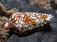 The deadly Cone Shell |
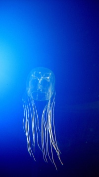 Box Jellyfish |
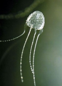 Irukandji Jelly Fish |
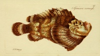 Drawing of a stonefish |
- The pretty but potentially cone shells found on the beach and shallow waters
- The extremely dangerous box and Irukandji jelly fish prevelent from May to October
- Stonefish that can be stepped upon in shallow waters
Charts
Uh, it's complicated - there are dozens of them.
- See also Queensland
Weather Information
See Queensland
Sources for weather information:
Regional Radio Nets
- See Queensland
- Also see World Cruiser's Nets
Islands in the Whitsundays
- Bedarra Island
- Brampton Island
- Daydream Island
- Dunk Island
- Fitzroy Island
- Green Island
- Haggerstone Island
- Hamilton Island
- Hayman Island
- Heron Island
- Hook Island
- Lady Elliot Island
- Lizard Island
- Long Island (QLD)
- Magnetic Island
- Orpheus Island
- Whitsunday Island
- Wilson Island
- ... and many, many more.
Mainland Ports and Anchorages
References & Publications
- 100 Magic Miles by David Colfelt. This book is the absolute must-have bible for cruising the Whitsunday Islands area of the Queensland coast. The book covers everything from harbours, anchorages, marine protection and national park zones, locations of courtesy moorings, dive and fishing spots, etc.
Cruiser's Friends
Contact details of "Cruiser's Friends" that can be contacted for local information or assistance.
Forum Discussions
List links to discussion threads on partnering forums. (see link for requirements)
External Links
Personal Notes
Last Visited & Details Checked (and updated here)
Date of member's visit to this Port/Stop & this page's details validated:
- April 2011 --Istioploos

|
|---|
|
Names: Haiqu, Istioploos |
| |
|---|
| | HOMEPAGE | Wiki Contents | Australia | Queensland | Whitsundays | |
