Ammouliani and Mt. Athos
From CruisersWiki
| Ammouliani and Mt. Athos
| |
| | |
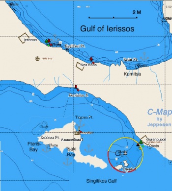
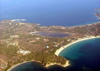
Ammouliani (Αμμουλιανή) is a small island across from Ouranoupoli of the Halkidiki peninsula. It is the best place to leave a yacht for visiting Mt. Athos since no yachts are allowed and visitors must use the local ferry from Ouranoupoli. It provides very good shelter, much better than Ouranoupoli where you can go with the dinghy.
Charts
- BA
- 1085 Kólpos Petalión to Srimonikos kólpos including Thermaikos kólpos
- NIMA
- 54360 Thessaloniki to Canakkale Bogazi Dardanelles
- 54363 Akra Akrathos to Dardanelles
- Greek
- 31 North Evoikos to Kavala Gulf
- 47 Aigaion Pelagos Northern Part
Weather
See Aegean Sea.
Passages
Popular passages/routes, timing, etc.
Communication
- Coast Guard - VHF channel 12, Tel. +30 23770 71248
- Olympia Radio - VHF channels 26 & 27
Also see World Cruiser's Nets.
The approaches to Ammouliani are straightforward.
Berthing
Ports
Ammouliani Village
Glastrì or Caique Harbour
Marinas & Yacht Clubs
None.
Anchorages
There are several anchorages on the island but if you are to leave the boat for a visit to Mt. Athos it is best to leave her in the small harbor of the village.
![]() Fteiis Bay [[Ammouliani and Mt. Athos#Fteiis Bay|Fteiis Bay]] 40°19.458'N, 023°53.653'E A pleasant bay on the south side of the island.
Fteiis Bay [[Ammouliani and Mt. Athos#Fteiis Bay|Fteiis Bay]] 40°19.458'N, 023°53.653'E A pleasant bay on the south side of the island.
![]() Tsaki Bay [[Ammouliani and Mt. Athos#Tsaki Bay|Tsaki Bay]] 40°19.100'N, 023°54.800'E A pleasant larger bay on the south side of the island. Anchor in sand. Good holding. Loud music plays during the day in summer, though not at night. A smaller one in the north-west is quieter. Make sure your anchor is holding in the weeds.
Tsaki Bay [[Ammouliani and Mt. Athos#Tsaki Bay|Tsaki Bay]] 40°19.100'N, 023°54.800'E A pleasant larger bay on the south side of the island. Anchor in sand. Good holding. Loud music plays during the day in summer, though not at night. A smaller one in the north-west is quieter. Make sure your anchor is holding in the weeds.
Warning: Beware of shallow rocks, one perfectly visible, if moving between the southern and northern bays.
Amenities
| Facilities | |
|---|---|
| Water | N/A (Not Available) |
| Electricity | N/A |
| Toilets | N/A |
| Showers | N/A |
| Laundry | There is a laundry in Patitiri |
| Garbage | Trash cans in Ammouliani |
| Supplies | |
| Fuel | Ammouliani: ask for Mr. Pavlos who brings the fuel with a small tanker |
| Bottled gas | N/A |
| Chandlers | None |
| Services | |
| Repairs | N/A |
| Internet | In internet cafés |
| Mobile connectivity | Reasonable 3G signal |
| Vehicle rentals | N/A |
Provisioning
![]() Ammouliani [[Ammouliani and Mt. Athos#Ammouliani|Ammouliani]] There is a small store in the village.
Ammouliani [[Ammouliani and Mt. Athos#Ammouliani|Ammouliani]] There is a small store in the village.
![]() Ouranoupolis [[Ammouliani and Mt. Athos#Ouranoupolis|Ouranoupolis]] 40°19.572'N, 023°58.832'E More stores here. There is only one dock forbidden to the yachts and reserved for daily cruises and for water taxis, but if you berth late in the morning, after all the cruise ships have left, the coastguard guy could let you to stay and buy provisions.
Ouranoupolis [[Ammouliani and Mt. Athos#Ouranoupolis|Ouranoupolis]] 40°19.572'N, 023°58.832'E More stores here. There is only one dock forbidden to the yachts and reserved for daily cruises and for water taxis, but if you berth late in the morning, after all the cruise ships have left, the coastguard guy could let you to stay and buy provisions.
Eating out
-
 in the village [[Ammouliani and Mt. Athos#in the village|in the village]] There is a small taverna.
- Ouranoupolis
-
 Ouranoupolis [[Ammouliani and Mt. Athos#Ouranoupolis|Ouranoupolis]] 40°19.572'N, 023°58.832'E Many restaurants here.
Transportation
Busses from Ouranoupolis.
Tourism
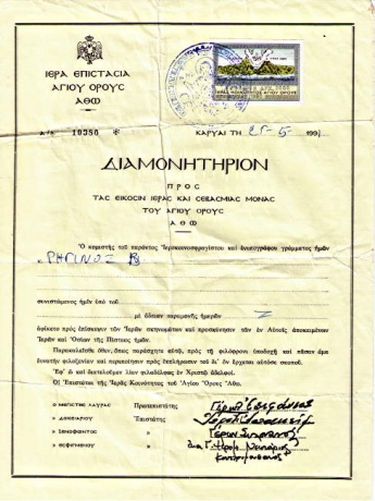 Diamonitirio — Permit to visit Mt. Athos |
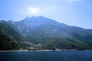 Mt. Athos |
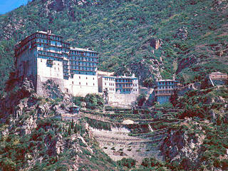 The Monastery of Simonos Petra |
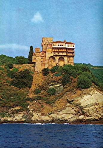 The Monastery of Stavronikita |
Places to Visit
Visit to Mt. Athos
The main attraction in this region is the incredible Mt. Athos— The Holy Mountain (Άγιον Όρος) with a peak of 2033 m (6670 ft). Mt. Athos is an autonomous monastic community, a state within Greece. No female visitors are allowed within 500 m of its shores. It consists of 20 independent monasteries and it is governed by a council in Karyes, a small town with shops populated entirely by monks. The state was established by the Byzantine Emperor Basil I in 883 AD and it under the jurisdiction of Ecumenical Patriarchate of Constantinople. Mt. Athos is a World Heritage Site.
At the end of the 11th century the monastic population on Mt. Athos reached 7000. Today there are twenty monasteries and their dependencies, that is sketes, kellia, kalyves, hermitages and dwellings. The above order reflects, in a way, the number of the monks that live in the foundation and the austerity of the life there. On the other hand, in a foundation where many monks live (such as a monastery or a skete), nobody can possess his own property. Everything belongs to the commune. Monks from various countries live in Mt. Athos. However, every person who comes to Mt. Athos and takes the monastic capacity becomes a Greek citizen.
All female mammals, including female humans, are prohibited on Mt. Athos. All visitors must be male and must arrive by the small ferry from Ouranoupolis. The ferry lands at the tiny port of Dafni where the new visitors disembark and apply for a permit called diamoniterion (διαμονητήριον). This is easily granted to Greek citizens and Orthodox Christians but for the rest a special visa is needed (for details see Visting Mt. Athos.
If you can, you must visit. Allow several days, and get a good guidebook. Within the Monasteries are housed incredible cultural treasures. Travel to the Monasteries is a time travel back to the Byzantine times.
Sail Around Mt. Athos
You can sail around Mt. Athos as long as you keep a distance of 500 m from its shore. Patrol boats enforce this. If a patrol boat appears it is best to have any female crew go below and not be obviously visible.
Friends
Contact details of "Cruiser's Friends" that can be contacted for local information or assistance.
Forums
List links to discussion threads on partnering forums. (see link for requirements)
Links
- Ammoulian at the Wikipedia
- Mt. Athos at the Wikipedia
- Mount Athos at the Wikivoyage
- Mount Athos Official site
References
See Greece.
Comments
We welcome users' contributions to the Wiki. Please click on Comments to view other users' comments, add your own personal experiences or recommend any changes to this page following your visit.
Verified by
Date of member's last visit to Ammouliani and Mt. Athos and this page's details validated:
- May 1991 --Istioploos

 Travels with S/Y Thetis
- July 2011 --Yachtbillabong

| This is a usable page of the cruising guide. However, please contribute if you can to help it grow further. Click on Comments to add your personal notes on this page or to discuss its contents. Alternatively, if you feel confident to edit the page, click on the edit tab at the top and enter your changes directly. |
| |
|---|
|
Names: Istioploos, Yachtbillabong |
