Madeira Island
From CruisersWiki
| Madeira There are Port(s) of Entry here
| |
The island of Madeira is at the top of a massive shield volcano that rises about 6 km (3.7 mi) from the floor of the Atlantic Ocean, on the Tore underwater mountain range.
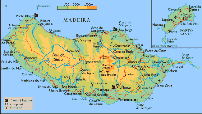
Madeira Island with a population of about 267,785, represents 93% of the archipelago's area, with 90% of the landmass above 500 m. It is the largest island of the group with an area of 741 km2 (286 sq mi), a length of 57 km (35 mi) (from Ponte de São Lourenço to Ponte do Pargo), while approximately 22 km (14 mi) at its widest point (from Ponte da Cruz to Ponte São Jorge), with a coastline of 150 km (93.21 mi). It has a mountain ridge that extends along the centre of the island, reaching 1862 meters (6,107 ft) at its highest point (Pico Ruivo), while much lower (below 200 meters) along its eastern extent.
Charts
See Madeira.
Weather
See Madeira.
Passages
See Madeira.
Islands
Communication
Add here VHF channel for coastguard, harbor masters. etc.
Also see World Cruiser's Nets.
The approach to Madeira is straightforward,
Entrance
There are several ports of entry in Madeira (see Madeira]).
For more details Portugal's entry procedures see Portugal.
Berthing
Ports
- Funchal |
 – port of entry |
 - Calheta |
 – port of entry |
 - Ponta do Sol |
 – needs data |
Marinas & Yacht Clubs
Use this section only if there are few marinas not covered in pages under Ports. Remove if not applicable.
Anchorages
List anchorages including the ones of nearby islands list under "Islands" above. If there is more then 1-3 paragraphs for a given anchorage, create a dedicated page for it (Port/Stop Template). Remove this section if not applicable.
Amenities
| Facilities | |
|---|---|
| Water | ? |
| Electricity | ? |
| Toilets | ? |
| Showers | ? |
| Laundry | ? |
| Garbage | ? |
| Supplies | |
| Fuel | ? |
| Bottled gas | ? |
| Chandlers | ? |
| Services | |
| Repairs | ? |
| Internet | ? |
| Mobile connectivity | ? |
| Vehicle rentals | ? |
Provisioning
Give the names and locations of supermarkets, grocery stores, bakeries, etc.
Eating out
Give the name of recommended restaurant, tavernas, pastry stores, etc.
Transportation
- From Madeira Grande there regular flights to Lisbon and other European cities
- There are daily flights and ferries, weather permitting, to Porto Santo
Tourism
History
Give a short history of the port.
Places to Visit
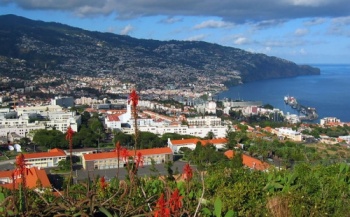
Funchal is a very attractive town. It is great fun to wander along its narrow streets.
A drive around the island of Madeira Grande is very interesting. Worth seeing are: the picturesque fishing village of Câmara de Lobos where Winston Churchill spent some time painting; Cabo Girão, an impressive cliff; Ribeira Brava from where the road goes north towards Serra de Agua up in the mountains; the desolate Paúl da Serra plateau and the green area of Cascata do Risco; and down to the N coast to the rocks of Porto Moniz. The surf breaking on these rocks is amazing. There you can have lunch in a restaurant built over the rocky promontory with windows surrounded by the surf. From Porto Moniz follow the the road along the N coast, going east. Stopped at the nicely restored miniscule village of São Vicente and then to Santana, where they have preserved some of the typical thatched houses. From Santana you can take the highway back to Funchal.
Friends
Contact details of "Cruiser's Friends" that can be contacted for local information or assistance.
Forums
List links to discussion threads on partnering forums. (see link for requirements)
Links
- Madeira Island at the Wikipedia
- Madeira Island at the Wikivoyage
- madeira-web
References
See Madeira.
Comments
We welcome users' contributions to the Wiki. Please click on Comments to view other users' comments, add your own personal experiences or recommend any changes to this page following your visit.
Verified by
Date of member's last visit to Madeira Island and this page's details validated:
- January 2005 --Istioploos

| This is a usable page of the cruising guide. However, please contribute if you can to help it grow further. Click on Comments to add your personal notes on this page or to discuss its contents. Alternatively, if you feel confident to edit the page, click on the edit tab at the top and enter your changes directly. |
| |
|---|
|
Names: Istioploos |


