Tarifa
From CruisersWiki
m (bot: Berthing) |
m (Text replace - "#References_.26_Publications|" to "#References|") |
||
| (5 intermediate revisions not shown) | |||
| Line 1: | Line 1: | ||
{{IsPartOf|North Atlantic|Spain|SW Spain}} | {{IsPartOf|North Atlantic|Spain|SW Spain}} | ||
{{TOC block}} | {{TOC block}} | ||
| - | + | ||
| - | {{Infobox |36 | + | {{Infobox |
| + | | lat= 36.00768| lon=-5.60275 | ||
| + | | name= Tarifa | ||
| + | | portofentry= | ||
| zoom= 16 | | zoom= 16 | ||
| + | | chartlet = y | ||
| image= TarifaAir.jpg | | image= TarifaAir.jpg | ||
| - | | imagetext= Aerial view of Tarifa | + | | imagetext= Aerial view of Tarifa |
| - | + | | summary= The harbour of '''Tarifa''' is situated at the entrance to the Strait of Gibraltar, 20 miles SE of [[Barbate]] and 15 miles SW of [[Gibraltar]]. The harbour lies immediately east of the island of the same name, which is connected to the mainland via a causeway. The harbour is a busy fishing and commercial port and not really suitable for yachts on passage, and should regard it as a port of refuge only. | |
| - | The harbour of Tarifa is situated at the entrance to the Strait of Gibraltar, 20 miles SE of [[Barbate]] and 15 miles SW of [[Gibraltar]]. | + | | notes= |
| - | + | | news= | |
| - | + | }} | |
| - | + | ||
| - | + | ||
| - | + | ||
| - | + | ||
| - | + | ||
==Charts== | ==Charts== | ||
; British Admiralty | ; British Admiralty | ||
| - | : 92 | + | : 92 - Cabo de Sao Vicente to the Strait of Gibraltar |
| - | : 142 | + | : 142 - Strait of Gibraltar |
| - | : 773 | + | : 773 - Strait of Gibraltar to Isla de Alborán |
; Spanish | ; Spanish | ||
: 44C | : 44C | ||
| Line 29: | Line 28: | ||
; Imray | ; Imray | ||
: C19 | : C19 | ||
| + | |||
| + | ==Weather== | ||
| + | From Barbate to Tarifa a yacht will often encounter a gradual strengthening in the wind as it approaches the Strait of Gibraltar at Tarifa. The 15 mile sail from Tarifa to Gibraltar is often accompanied by fresh to strong winds and rough seas, especially with an easterly wind against the prevailing east-going current. Not for nothing is Tarifa often described as the windsurfing capital of Europe. During the summer months (May to September) the winds here are either the westerly ''poniente'', which usually blows at around force 4-5 (although it can reach gale force in winter and early spring, when it is known locally as the ''vendaval'') or the easterly ''levanter'', which normally blows in summer at force 4-5, but has been known on occasion to funnel through the Strait at anything up to force 8 or 9 and render it all but impassible to smaller yachts. | ||
| + | |||
| + | Sources for Weather forecasts: | ||
| + | * | ||
| + | * | ||
| + | |||
| + | ==Passages== | ||
| + | ''See [[South West coast of Spain#Passages|SW Spain]]''. | ||
| + | * | ||
| + | |||
| + | ==Islands== | ||
| + | * Tarifa Island | ||
==Communication== | ==Communication== | ||
| + | {{Green|Add here VHF channel for the coastguard, harbor masters. etc.}} | ||
* | * | ||
* | * | ||
''Also see [[World MM Nets|World Cruiser's Nets]]''. | ''Also see [[World MM Nets|World Cruiser's Nets]]''. | ||
| - | |||
| - | |||
| - | |||
==Navigation== | ==Navigation== | ||
| - | There are often tunny nets off the coast in the approaches to Tarifa, especially to the west. | + | {{Image right| TarifaHarbour.jpg| Entrance to Tarifa harbour }} |
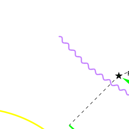
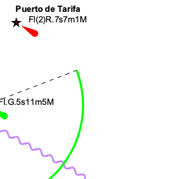
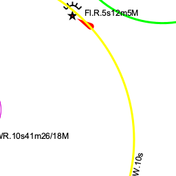
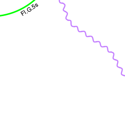
| + | There are often tunny nets off the coast in the approaches to Tarifa, especially to the west. The island of Tarifa, with its lighthouse at the southern tip, is conspicuous from several miles off. The harbour lies 0.75 miles NNE of the tip of the island. A tall statue marks the end of the outer breakwater. | ||
| + | |||
| + | {{Caution}}is needed on entry since large ferries use the harbour. | ||
==Berthing== | ==Berthing== | ||
| - | |||
Berth alongside the long central jetty to the northern end of the harbour wherever there is space. | Berth alongside the long central jetty to the northern end of the harbour wherever there is space. | ||
| Line 49: | Line 62: | ||
None. | None. | ||
| - | + | ==Anchorages== | |
| - | In settled weather, anchor to the east or west of the causeway joining Tarifa Island to the mainland, depending on wind direction. | + | In settled weather, anchor to the east or west of the causeway joining Tarifa Island to the mainland, depending on wind direction. If anchoring on the eastern side, be sure to anchor well clear of the harbour approaches. There is an uncomfortable swell here in most conditions. |
| - | == | + | ==Amenities== |
| - | + | {{tlist | |
| - | + | ||
| - | + | |header|Facilities | |
| - | + | ||
| - | + | |Water| There are reported to be a couple of water taps around the harbour but no other facilities | |
| - | There are reported to be a couple of water taps around the harbour but no other facilities | + | |Electricity| N/A (Not Available) |
| + | |Toilets| N/A | ||
| + | |Showers| N/A | ||
| + | |Laundry| N/A | ||
| + | |Garbage| Bins around the harbour | ||
| - | + | |header|Supplies | |
| - | + | |Fuel| N/A | |
| - | {{ | + | |Bottled gas| {{MagentaText|?}} |
| - | + | |Chandlers| None | |
| - | + | |header|Services | |
| - | + | |Repairs| N/A | |
| + | |Internet| {{MagentaText|?}} | ||
| + | |Mobile connectivity| {{MagentaText|?}} | ||
| + | |Vehicle rentals| {{MagentaText|?}} | ||
| + | }} | ||
| - | ==== | + | ==Provisioning== |
| + | All usual, provisions shops in the town. | ||
| + | |||
| + | ==Eating out== | ||
Several good fish restaurants in the town. | Several good fish restaurants in the town. | ||
| - | == | + | ==Transportation== |
| - | + | * The nearest airports are [[Malaga]] a 1.5 hour drive, [[Gibraltar]], 35 minutes, Jerez de la Frontera a 1 hour drive | |
| + | * From the port a fast ferry by FRS leaves every other hour to the port of [[Tangier]], [[Morocco]] | ||
| + | * You can get the bus to Tarifa from from [[Algeciras]], [[La Linea]], [[Malaga]], Jerez, and [[Cadiz]] | ||
| - | ==== | + | ==Tourism== |
| - | + | {{Image right| TarifaCastle.jpg| The 13th century Castillo Guzmán el Bueno }} | |
| + | The old Moorish town centre is reportedly quite attractive. Close to Tarifa is the impressive 13th-century castle of Castillo Guzmán el Bueno. | ||
| - | + | For keen birdfanciers, Tarifa is a great place during early spring and autumn for watching birds on migration, especially storks. | |
| - | + | ||
| - | + | ||
| - | + | ||
| - | + | ||
| - | + | ||
| - | + | ||
| - | + | ||
| - | + | ||
| - | + | ||
| - | + | ||
| - | + | ||
| - | + | ||
| - | + | ||
| - | + | ||
==Friends== | ==Friends== | ||
| Line 105: | Line 116: | ||
==Links== | ==Links== | ||
* {{wikipedia}} | * {{wikipedia}} | ||
| + | * {{Wikivoyage}} | ||
* | * | ||
| - | ==References | + | ==References== |
| - | ''See [[Spain# | + | ''See [[Spain#References|Spain]]''. |
{{Comments}} | {{Comments}} | ||
| - | |||
* | * | ||
* | * | ||
{{Verified by}} | {{Verified by}} | ||
| - | |||
* Details based on internet research and reports by visiting cruisers (please update if possible) --[[User:Atheneoflymington|Athene of Lymington]] 16:03, 14 April 2010 (UTC) | * Details based on internet research and reports by visiting cruisers (please update if possible) --[[User:Atheneoflymington|Athene of Lymington]] 16:03, 14 April 2010 (UTC) | ||
* | * | ||
Latest revision as of 15:01, 21 August 2018
| Tarifa
| |
| |
 Aerial view of Tarifa |
The harbour of Tarifa is situated at the entrance to the Strait of Gibraltar, 20 miles SE of Barbate and 15 miles SW of Gibraltar. The harbour lies immediately east of the island of the same name, which is connected to the mainland via a causeway. The harbour is a busy fishing and commercial port and not really suitable for yachts on passage, and should regard it as a port of refuge only.
Charts
- British Admiralty
- 92 - Cabo de Sao Vicente to the Strait of Gibraltar
- 142 - Strait of Gibraltar
- 773 - Strait of Gibraltar to Isla de Alborán
- Spanish
- 44C
- 105
- 445
- 445B
- 4450
- Imray
- C19
Weather
From Barbate to Tarifa a yacht will often encounter a gradual strengthening in the wind as it approaches the Strait of Gibraltar at Tarifa. The 15 mile sail from Tarifa to Gibraltar is often accompanied by fresh to strong winds and rough seas, especially with an easterly wind against the prevailing east-going current. Not for nothing is Tarifa often described as the windsurfing capital of Europe. During the summer months (May to September) the winds here are either the westerly poniente, which usually blows at around force 4-5 (although it can reach gale force in winter and early spring, when it is known locally as the vendaval) or the easterly levanter, which normally blows in summer at force 4-5, but has been known on occasion to funnel through the Strait at anything up to force 8 or 9 and render it all but impassible to smaller yachts.
Sources for Weather forecasts:
Passages
See SW Spain.
Islands
- Tarifa Island
Communication
Add here VHF channel for the coastguard, harbor masters. etc.
Also see World Cruiser's Nets.

There are often tunny nets off the coast in the approaches to Tarifa, especially to the west. The island of Tarifa, with its lighthouse at the southern tip, is conspicuous from several miles off. The harbour lies 0.75 miles NNE of the tip of the island. A tall statue marks the end of the outer breakwater.
Caution: is needed on entry since large ferries use the harbour.
Berthing
Berth alongside the long central jetty to the northern end of the harbour wherever there is space.
Marinas & Yacht Clubs
None.
Anchorages
In settled weather, anchor to the east or west of the causeway joining Tarifa Island to the mainland, depending on wind direction. If anchoring on the eastern side, be sure to anchor well clear of the harbour approaches. There is an uncomfortable swell here in most conditions.
Amenities
| Facilities | |
|---|---|
| Water | There are reported to be a couple of water taps around the harbour but no other facilities |
| Electricity | N/A (Not Available) |
| Toilets | N/A |
| Showers | N/A |
| Laundry | N/A |
| Garbage | Bins around the harbour |
| Supplies | |
| Fuel | N/A |
| Bottled gas | ? |
| Chandlers | None |
| Services | |
| Repairs | N/A |
| Internet | ? |
| Mobile connectivity | ? |
| Vehicle rentals | ? |
Provisioning
All usual, provisions shops in the town.
Eating out
Several good fish restaurants in the town.
Transportation
- The nearest airports are Malaga a 1.5 hour drive, Gibraltar, 35 minutes, Jerez de la Frontera a 1 hour drive
- From the port a fast ferry by FRS leaves every other hour to the port of Tangier, Morocco
- You can get the bus to Tarifa from from Algeciras, La Linea, Malaga, Jerez, and Cadiz
Tourism

The old Moorish town centre is reportedly quite attractive. Close to Tarifa is the impressive 13th-century castle of Castillo Guzmán el Bueno.
For keen birdfanciers, Tarifa is a great place during early spring and autumn for watching birds on migration, especially storks.
Friends
Contact details of "Cruiser's Friends" that can be contacted for local information or assistance.
Forums
List links to discussion threads on partnering forums. (see link for requirements)
Links
References
See Spain.
Comments
We welcome users' contributions to the Wiki. Please click on Comments to view other users' comments, add your own personal experiences or recommend any changes to this page following your visit.
Verified by
Date of member's last visit to Tarifa and this page's details validated:
- Details based on internet research and reports by visiting cruisers (please update if possible) --Athene of Lymington 16:03, 14 April 2010 (UTC)
If you provide a lot of info and this page is almost complete, change {{Page outline}} to {{Page useable}}.
| This page has an outline in place but needs completing. Please contribute if you can to help it grow further. Click on Comments to suggest further content or alternatively, if you feel confident to edit this page, click on the edit tab at the top and enter your changes directly. |
| |
|---|
|
Names: Athene of Lymington |