Chalki
From CruisersWiki
Istioploos (Talk | contribs) (New material) |
Istioploos (Talk | contribs) (Re-format) |
||
| Line 1: | Line 1: | ||
==Chálki== | ==Chálki== | ||
| - | {| | + | {| class="infobox bordered" style="width: 33em; text-align: left; font-size: 85%;" |
|- | |- | ||
| - | | | + | | colspan="2" style="text-align:center; font-size: smaller;" | {{Small info}} (''Click links for more information'') |
| - | + | |- | |
| + | ! <center>[[image:World_icon.png]]</center> | ||
| + | | {{Coord|36|13.3|N|27|36.9|E|}} | ||
| + | |- | ||
| + | ! <center>[[image:Photo_icon.png]]</center> | ||
| + | | [http://www.panoramio.com/map/#lt=36.224058&ln=27.578087&z=5&k=0&a=1&tab=2 Photo gallery] | ||
| + | |- | ||
| + | ! <center>[[image:Chart_icon.png]]</center> | ||
| + | | [http://mapserver.mytopo.com/homepage/index.cfm?lat=36.224264820656856&lon=27.568662683280056&scale=250000&zoom=100&type=0&icon=0&width=498&height=498&searchscope=dom&CFID=29704&CFTOKEN=79115022&scriptfile=http://mapserver.mytopo.com/homepage/index.cfm&latlontype=DMS Local chartlet] | ||
|} | |} | ||
| - | |||
| - | |||
| - | |||
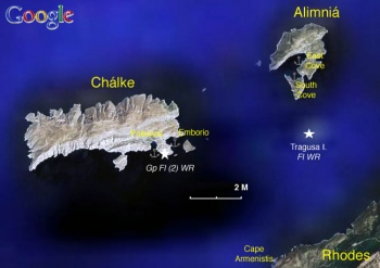
Chálki (Χάλκη) or [http://en.wikipedia.org/wiki/Halki_(Greece) Halki] or Khalki is a small island of 2 km<sup>2</sup> and about 300 inhabitants located approximately 7 nM west of [[Rhodes]]. It is a mountainous off-the-beaten-track island with many sandy beaches. There are many nice neoclassical pastel colored houses surrounding the harbor whose owners have mostly immigrated and live in Florida. The main street is named [http://en.wikipedia.org/wiki/Tarpon_Springs Tarpon Springs] Boulevard. | Chálki (Χάλκη) or [http://en.wikipedia.org/wiki/Halki_(Greece) Halki] or Khalki is a small island of 2 km<sup>2</sup> and about 300 inhabitants located approximately 7 nM west of [[Rhodes]]. It is a mountainous off-the-beaten-track island with many sandy beaches. There are many nice neoclassical pastel colored houses surrounding the harbor whose owners have mostly immigrated and live in Florida. The main street is named [http://en.wikipedia.org/wiki/Tarpon_Springs Tarpon Springs] Boulevard. | ||
| Line 15: | Line 20: | ||
Chálki famous for keeping its old music and traditional songs the 15 syllable ''mandinádes.'' | Chálki famous for keeping its old music and traditional songs the 15 syllable ''mandinádes.'' | ||
| - | + | ==Charts== | |
| - | + | [[Image:Greece_Chalke_S.jpg|350px|thumb|right|Satellite View of Chalki & Alimnia<br/>''Click for larger view'']] | |
| - | + | ||
| - | + | ||
| - | + | ||
| - | + | ||
| - | + | ||
| - | + | ||
| - | + | ||
| - | + | ||
| - | + | ;BA | |
| + | : 872 Kalimnos to Rhodes | ||
| + | : 1667 Rhodes island | ||
| + | ; Imray-Tetra | ||
| + | : G35 Dodecanese and the Coast of Turkey | ||
| + | ; NIMA | ||
| + | : 54400 Nisos Samos to Nisos Rhodhos | ||
| + | : 54416 Nisos Rhodhos | ||
| + | ; Greek | ||
| + | : 451 Leros to Rhodos | ||
| + | |||
| + | ==Radio Nets== | ||
''Also see [[HF_Radio|Cruiser's Nets]]'' | ''Also see [[HF_Radio|Cruiser's Nets]]'' | ||
| + | |||
* Greek Coast Guard - VHF channel 12 | * Greek Coast Guard - VHF channel 12 | ||
* Olympia Radio - VHF channels 01 & 63 | * Olympia Radio - VHF channels 01 & 63 | ||
| - | ===Approach and Navigation | + | ==Weather== |
| + | ''See [[Aegean_Sea#Weather_and_Winds|Aegean Sea]]''. | ||
| + | |||
| + | ==Approach and Navigation== | ||
Approaches to Chálki are straightforward. | Approaches to Chálki are straightforward. | ||
| - | == | + | ==Check-in facilities== |
| + | None. | ||
| + | ==Ports and Popular Stops== | ||
| + | ===Ports=== | ||
====Emborio==== | ====Emborio==== | ||
| - | + | {| | |
| - | + | |valign="top"|[[image:World_icon.png]] {{Coord|36|13.3|N|27|36.9|E|}}<br/> | |
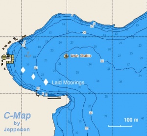
Emborió or Chálki is the only anchorage on the island and provides reasonable shelter from the ''meltemi'' although it is gusty. On the north side of the harbour a new T-shaped pontoon has been installed. Either anchor moor on the outside of the T section, dropping anchor in depths of 12-15 metres, or go alongside the inner section of the pontoon where directed. There were also a few laid moorings at the time of visit (July 2009) along the southern side of the pontoon joining the T section to the shore. Water and electricity is available on a card system - €3 for 500 litres of water and €3 for 300 kW electricity. Typical charge for a night’s mooring is around €1 per metre overall length. There seems to be a constant swell in the harbour in most wind conditions and, since it rolls directly onto the T, the berths on anchor moor on the outside are usually the most comfortable. The harbor can be very crowded at peak times and you may not find room, especially if you arrive late. In such circumstances, the best near-by all weather shelter is at [[Alimnia|Alimniá.]] | Emborió or Chálki is the only anchorage on the island and provides reasonable shelter from the ''meltemi'' although it is gusty. On the north side of the harbour a new T-shaped pontoon has been installed. Either anchor moor on the outside of the T section, dropping anchor in depths of 12-15 metres, or go alongside the inner section of the pontoon where directed. There were also a few laid moorings at the time of visit (July 2009) along the southern side of the pontoon joining the T section to the shore. Water and electricity is available on a card system - €3 for 500 litres of water and €3 for 300 kW electricity. Typical charge for a night’s mooring is around €1 per metre overall length. There seems to be a constant swell in the harbour in most wind conditions and, since it rolls directly onto the T, the berths on anchor moor on the outside are usually the most comfortable. The harbor can be very crowded at peak times and you may not find room, especially if you arrive late. In such circumstances, the best near-by all weather shelter is at [[Alimnia|Alimniá.]] | ||
| Line 45: | Line 60: | ||
<font color="red">Danger:</font> On the SE of the island, W of the tiny Nisaki island there is a rock, Xera, which is awash and not always easy to see. | <font color="red">Danger:</font> On the SE of the island, W of the tiny Nisaki island there is a rock, Xera, which is awash and not always easy to see. | ||
| - | <center><gallery caption="Emborio" widths="200" heights="140px" perrow=" | + | |valign="top"|[[Image:Greece_Chalke_Emborio_h.jpg|300px|thumb|right|Chart of Emborió Bay - [http://mapserver.maptech.com/homepage/index.cfm?lat=36.221667&lon=27.615&scale=24000&zoom=50&type=1 Chartlet]<br/>''Click for larger view'']] |
| + | |} | ||
| + | |||
| + | <center><gallery caption="Emborio" widths="200" heights="140px" perrow="3"> | ||
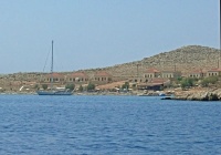
Image:Greece_Chalke1.jpg|The Harbor of Chálki<br/>''Click for larger view'' | Image:Greece_Chalke1.jpg|The Harbor of Chálki<br/>''Click for larger view'' | ||
| - | |||
Image:Greece_Chalke3.jpg|The T-shaped pontoon<br/>''Click for larger view'' | Image:Greece_Chalke3.jpg|The T-shaped pontoon<br/>''Click for larger view'' | ||
| - | Image:Greece_Chalke4.jpg|Anchoring off W of the harbor<br/>''Click for larger view'' | + | Image:Greece_Chalke4.jpg|Anchoring off, W of the harbor<br/>''Click for larger view'' |
</gallery></center> | </gallery></center> | ||
===Anchorages=== | ===Anchorages=== | ||
====Potamos==== | ====Potamos==== | ||
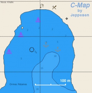
| - | + | [[Image:Greece_Chalke_Potamos_h.jpg|300px|thumb|right|Chart of Potamos<br/>''Click for larger view'']] | |
| - | | | + | [[image:World_icon.png]] {{Coord|36|13.2|N|27|36.3|E|}} |
Potamos is a small bay S of [[#Emborio|Emborió]] and within walking distance. It is possible to anchor here. | Potamos is a small bay S of [[#Emborio|Emborió]] and within walking distance. It is possible to anchor here. | ||
| - | + | ==Marinas & Yacht Clubs== | |
| - | + | None. | |
| - | === | + | ==Yacht Services and Repairs== |
| - | + | ====Marine Stores==== | |
| - | + | None. | |
| - | + | ====Yacht Services/Repairs/Yards==== | |
| + | None. | ||
| - | ===Fuel, Water, & Electricity=== | + | ====Fuel, Water, & Electricity==== |
| - | Water | + | ; Fuel |
| + | : N/A | ||
| + | ; Water | ||
| + | : Available on pontoon in [[#Emborio|Emborio]] | ||
| + | ; Electricity | ||
| + | : Available on pontoon in [[#Emborio|Emborio]] | ||
| - | === | + | ==Offshore Islands== |
| - | + | None. | |
| + | |||
| + | ==Tourism and Things to do Ashore== | ||
| + | {| class="wikitable" align=right | ||
| + | |- | ||
| + | |[[Image:Greece_Chalke2.jpg|250px]]<br/><small>The colorful houses in Emborió<br/>''Click for larger view''</small> | ||
| + | |- | ||
| + | |[[Image:Greece_Chalki2.jpg|250px]]<br/><small>Tarpon Springs Boulevard<br/>''Click for larger view''</small> | ||
| + | |} | ||
| + | ===Tourism=== | ||
| + | At [[#Emborio|Emborió]] one can walk along the ''Tarpon Springs Boulevard'' to the beach ([[#Potamos|Potamos]]). Also one can visit the church of Ayios Nikólaos with the tallest campanile in the [http://en.wikipedia.org/wiki/Dodecanese Dodecanese]. | ||
| + | |||
| + | About an hour uphill walk from Emborio there is the abandoned town Chorió dominated by the castle of the [http://en.wikipedia.org/wiki/Knights_Hospitaller Knights of St. John] which is built on top of the ancient acropolis. The view from here is spectacular, on clear days one can see as far as [[Karpathos]] and [[Crete]]. Also, at Chorió there is the Byzantine church of Panayia with a few frescoes. | ||
===Grocery & Supply Stores=== | ===Grocery & Supply Stores=== | ||
| Line 83: | Line 118: | ||
===Internet/WiFi=== | ===Internet/WiFi=== | ||
Available? | Available? | ||
| + | |||
| + | ===Laundry=== | ||
| + | N/A. | ||
===Motorbike & Car Rentals=== | ===Motorbike & Car Rentals=== | ||
* | * | ||
| - | |||
| - | |||
| - | |||
| - | |||
| - | |||
| - | |||
===Garbage Disposal=== | ===Garbage Disposal=== | ||
| Line 99: | Line 131: | ||
Ferries to [[Rhodes]]. | Ferries to [[Rhodes]]. | ||
| - | + | ==Routes/Passages To/From== | |
| - | + | * [[Cruising the Dodechanese Islands]] | |
| - | + | ==Cruiser's Friends== | |
| - | + | ||
| - | + | ||
| - | + | ||
Contact details of "Cruiser's Friends" that can be contacted for local information or assistance. | Contact details of "Cruiser's Friends" that can be contacted for local information or assistance. | ||
* | * | ||
| - | + | ==Forum Discussions== | |
List links to discussion threads on the Cruiser Log Forum | List links to discussion threads on the Cruiser Log Forum | ||
* | * | ||
| Line 115: | Line 144: | ||
* | * | ||
| - | + | ==External Links== | |
* [http://en.wikipedia.org/wiki/Halki_(Greece) Halki Greece] Wikipedia | * [http://en.wikipedia.org/wiki/Halki_(Greece) Halki Greece] Wikipedia | ||
* | * | ||
* | * | ||
| - | === | + | ==References & Publications== |
| - | + | See [[Greece#References_&_Publications|Greece]]. | |
| - | + | ||
| - | + | ==''Last Visited & Details Checked (and updated here)''== | |
''Date of member's visit to this Port/Stop & this page's details validated'': | ''Date of member's visit to this Port/Stop & this page's details validated'': | ||
* July 2009 --[[User:Summercruise|Summercruise]] 14:50, 10 July 2009 (UTC) | * July 2009 --[[User:Summercruise|Summercruise]] 14:50, 10 July 2009 (UTC) | ||
* July 2009 --[[User:Atheneoflymington|Atheneoflymington]] 10:55, 11 July 2009 (UTC) | * July 2009 --[[User:Atheneoflymington|Atheneoflymington]] 10:55, 11 July 2009 (UTC) | ||
* August 2009 --[[User:Istioploos|Istioploos]] [[Image:Greece_Icon.png]] | * August 2009 --[[User:Istioploos|Istioploos]] [[Image:Greece_Icon.png]] | ||
| + | |||
| + | ==Personal Notes== | ||
| + | * From [[Karpathos#Pigadia|Pigadhia]] on [[Karpathos]] to [[#Emborio|Emborio]], Halki - 48 miles in six hours in WNW 5 to 6 on yankee, staysail and single reefed main (5 July 2009). For him: cracking; for her: scary --[[User:Atheneoflymington|Atheneoflymington]] 13:14, 21 July 2009 (UTC). | ||
| + | * | ||
Revision as of 22:25, 8 November 2009
Chálki
| | |
| | 36°13.3′N, 27°36.9′E |
|---|---|
| | Photo gallery |
| | Local chartlet |
Chálki (Χάλκη) or Halki or Khalki is a small island of 2 km2 and about 300 inhabitants located approximately 7 nM west of Rhodes. It is a mountainous off-the-beaten-track island with many sandy beaches. There are many nice neoclassical pastel colored houses surrounding the harbor whose owners have mostly immigrated and live in Florida. The main street is named Tarpon Springs Boulevard.
The island was named Chálki from its copper (chalkos - χαλκός) mines which flourished in antiquity. Its first inhabitants were Pelasgians, Karians, Dorians, Phoenicians. From excavations on the island it appears that it was flourishing from the 10 century BC to the classical period during which it was under Athenian influence. In the middle ages the island was possessed by the Arabs, the Byzantines, the Venetians, and the Genoese. It was then part of the Ottoman Empire until it was sold to the Italians in the 19th century AD. After World War II, in 1948 Chálki along with the rest of the Dodecanese was united with Greece. The island had seen some prosperity in the early part of this century but when the trade of sponges, sponge diving being its chief occupation, collapsed it faced hard times and many of its inhabitants immigrated to the US.
Chálki famous for keeping its old music and traditional songs the 15 syllable mandinádes.
Charts
- BA
- 872 Kalimnos to Rhodes
- 1667 Rhodes island
- Imray-Tetra
- G35 Dodecanese and the Coast of Turkey
- NIMA
- 54400 Nisos Samos to Nisos Rhodhos
- 54416 Nisos Rhodhos
- Greek
- 451 Leros to Rhodos
Radio Nets
Also see Cruiser's Nets
- Greek Coast Guard - VHF channel 12
- Olympia Radio - VHF channels 01 & 63
Weather
See Aegean Sea.
Approaches to Chálki are straightforward.
Check-in facilities
None.
Ports and Popular Stops
Ports
Emborio
Emborió or Chálki is the only anchorage on the island and provides reasonable shelter from the meltemi although it is gusty. On the north side of the harbour a new T-shaped pontoon has been installed. Either anchor moor on the outside of the T section, dropping anchor in depths of 12-15 metres, or go alongside the inner section of the pontoon where directed. There were also a few laid moorings at the time of visit (July 2009) along the southern side of the pontoon joining the T section to the shore. Water and electricity is available on a card system - €3 for 500 litres of water and €3 for 300 kW electricity. Typical charge for a night’s mooring is around €1 per metre overall length. There seems to be a constant swell in the harbour in most wind conditions and, since it rolls directly onto the T, the berths on anchor moor on the outside are usually the most comfortable. The harbor can be very crowded at peak times and you may not find room, especially if you arrive late. In such circumstances, the best near-by all weather shelter is at Alimniá. Alternatively you can anchor off in a cove just W of the harbor. Easy distance by dinghy. Danger: On the SE of the island, W of the tiny Nisaki island there is a rock, Xera, which is awash and not always easy to see. |
Greece Chalke1.jpg
The Harbor of Chálki |
Greece Chalke3.jpg
The T-shaped pontoon |
Anchorages
Potamos
![]() 36°13.2′N, 27°36.3′E
Potamos is a small bay S of Emborió and within walking distance. It is possible to anchor here.
36°13.2′N, 27°36.3′E
Potamos is a small bay S of Emborió and within walking distance. It is possible to anchor here.
Marinas & Yacht Clubs
None.
Yacht Services and Repairs
Marine Stores
None.
Yacht Services/Repairs/Yards
None.
Fuel, Water, & Electricity
Offshore Islands
None.
Tourism and Things to do Ashore
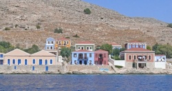 The colorful houses in Emborió Click for larger view |
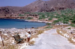 Tarpon Springs Boulevard Click for larger view |
Tourism
At Emborió one can walk along the Tarpon Springs Boulevard to the beach (Potamos). Also one can visit the church of Ayios Nikólaos with the tallest campanile in the Dodecanese.
About an hour uphill walk from Emborio there is the abandoned town Chorió dominated by the castle of the Knights of St. John which is built on top of the ancient acropolis. The view from here is spectacular, on clear days one can see as far as Karpathos and Crete. Also, at Chorió there is the Byzantine church of Panayia with a few frescoes.
Grocery & Supply Stores
Eateries
Internet/WiFi
Available?
Laundry
N/A.
Motorbike & Car Rentals
Garbage Disposal
Trash cans in the harbor.
Transportation
Ferries to Rhodes.
Routes/Passages To/From
Cruiser's Friends
Contact details of "Cruiser's Friends" that can be contacted for local information or assistance.
Forum Discussions
List links to discussion threads on the Cruiser Log Forum
External Links
- Halki Greece Wikipedia
References & Publications
See Greece.
Last Visited & Details Checked (and updated here)
Date of member's visit to this Port/Stop & this page's details validated:
- July 2009 --Summercruise 14:50, 10 July 2009 (UTC)
- July 2009 --Atheneoflymington 10:55, 11 July 2009 (UTC)
- August 2009 --Istioploos

Personal Notes
- From Pigadhia on Karpathos to Emborio, Halki - 48 miles in six hours in WNW 5 to 6 on yankee, staysail and single reefed main (5 July 2009). For him: cracking; for her: scary --Atheneoflymington 13:14, 21 July 2009 (UTC).
| |
|---|
| | HOMEPAGE | Wiki Contents | Mediterranean | Aegean Sea | Greece | Chalki | |
.
