Coast W of Marmaris and Sombeki Korfesi
From CruisersWiki
Istioploos (Talk | contribs) m (Typos) |
Istioploos (Talk | contribs) (Chartlet) |
||
| Line 1: | Line 1: | ||
| - | + | An online cruising guide for yachts sailing around the Coast W of Marmaris & Sömbeki Körfesi in [[Turkey]]. | |
| - | + | ||
| + | {| class="wikitable" style="margin: 1em auto 1em auto;" | ||
| + | | valign="top" | | ||
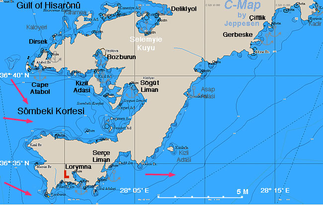
| + | <imagemap> | ||
| + | Image:Turkey_Serce_r.jpg|650px|center | ||
| + | rect 317 2 399 38 [[Hisaronu_Korfezi_to_Teke_Burnu#Delikliyol Limani|Delikliyol]] | ||
| + | rect 55 71 115 125 [[Hisaronu_Korfezi_to_Teke_Burnu#Dirsek|Dirsek]] | ||
| + | rect 187 97 277 142 [[#Bozburun|Bozburun]] | ||
| + | rect 501 27 555 63 [[#Çiftlik|Çiftlik]] | ||
| + | rect 447 59 538 102 [[#Gerbeske|Gerbeske]] | ||
| + | rect 184 303 234 359 [[#Serçe_Liman|Serçe Liman]] | ||
| + | rect 124 327 187 390 [[#Loryma|Loryma]] | ||
| + | rect 247 161 323 231 [[#Sögüt|Sögüt]] | ||
| + | rect 62 123 108 191 [[#Cove E of Atabol Burun|Cove E of Atabol Burun]] | ||
| + | poly 150 162 193 147 213 185 199 195 147 188 [[#Kizil Adasi|Kizil Adasi]] | ||
| + | </imagemap> | ||
| + | <center>Coast W of Marmaris & Sömbeki Körfesi - <em>For details click on a name or an area</em></center> | ||
| + | |} | ||
| + | |||
{{TOCleft}} | {{TOCleft}} | ||
This area covers the peninsula W of [[Marmaris]] (Karaburun) and then to the N Sömbeki Körfesi, also known as the Gulf of [[Symi]] or Yesilova Körfezi. There are several anchorages and one small harbor, [[#Bozburun|Bozburun]]. | This area covers the peninsula W of [[Marmaris]] (Karaburun) and then to the N Sömbeki Körfesi, also known as the Gulf of [[Symi]] or Yesilova Körfezi. There are several anchorages and one small harbor, [[#Bozburun|Bozburun]]. | ||
| Line 30: | Line 48: | ||
All approaches are straightforward except that the entrance to [[#Serçe Liman|Serçe Liman]] is hard to see from a distance. | All approaches are straightforward except that the entrance to [[#Serçe Liman|Serçe Liman]] is hard to see from a distance. | ||
| - | + | {{Warning}} There can be very strong gusts down the steep slopes. | |
==Ports, Anchorages, and Islands== | ==Ports, Anchorages, and Islands== | ||
===Ports=== | ===Ports=== | ||
| - | ==== Bozburun==== | + | ====Bozburun==== |
| - | + | {{Infobox |36|41.52|N|28|2.56|E| | |
| - | + | | name= Bozburun | |
| - | + | | mapzoom= 17 | |
| - | + | | image= Turkey_Bozburun_h.jpg | |
| - | + | | imagetext= Chart of Bozburun - ''Click for larger view'' | |
| - | + | }} | |
| - | | | + | |
| - | + | ||
| - | | | + | |
| - | | | + | |
| - | + | ||
| - | + | ||
| - | | | + | |
| - | + | ||
| - | + | ||
[http://en.wikipedia.org/wiki/Bozburun Bozburun] is an attractive village with a nice harbor. There is an attendant in the harbor who will direct you, usually side-to. There is water and electricity (included with the harbor dues) and fuel can be delivered. | [http://en.wikipedia.org/wiki/Bozburun Bozburun] is an attractive village with a nice harbor. There is an attendant in the harbor who will direct you, usually side-to. There is water and electricity (included with the harbor dues) and fuel can be delivered. | ||
=====Last Visited & Details Checked (and updated here)===== | =====Last Visited & Details Checked (and updated here)===== | ||
''Date of member's visit to this Port/Stop & this page's details validated'': | ''Date of member's visit to this Port/Stop & this page's details validated'': | ||
| - | * September 2002 | + | * September 2002 {{Istioploos2}} |
* June 2007 --[[User:Atheneoflymington|Atheneoflymington]] 18:03, 12 January 2010 (UTC) | * June 2007 --[[User:Atheneoflymington|Atheneoflymington]] 18:03, 12 January 2010 (UTC) | ||
| + | * | ||
| - | + | {{Image center|Bozburun.jpeg |Bozburun - ''Click for larger view'' |400px }} | |
| + | {{hold vertical}} | ||
===Marinas & Yacht Clubs=== | ===Marinas & Yacht Clubs=== | ||
| Line 64: | Line 75: | ||
===Anchorages=== | ===Anchorages=== | ||
====Çiftlik==== | ====Çiftlik==== | ||
| - | { | + | {{Infobox |36|42.92|N|28|14.47|E| |
| - | + | | name= Çiftlik | |
| - | + | | mapzoom= 14 | |
| - | + | | image= Turkey_Ciftlik_m.jpg | |
| - | + | | imagetext= Chart of Çiftlik - ''Click for larger view'' | |
| - | + | }} | |
| - | | | + | |
| - | + | ||
| - | | | + | |
| - | | | + | |
| - | + | ||
| - | + | ||
| - | | | + | |
| - | + | ||
| - | + | ||
Çiftlik is a protected cove about 14 nM SW from Marmaris. There are several seaside restaurants here serving good food. You can either anchor off at the northern end of the bay or tie up to one of the four restaurant jetties. | Çiftlik is a protected cove about 14 nM SW from Marmaris. There are several seaside restaurants here serving good food. You can either anchor off at the northern end of the bay or tie up to one of the four restaurant jetties. | ||
| Line 85: | Line 87: | ||
=====Last Visited & Details Checked (and updated here)===== | =====Last Visited & Details Checked (and updated here)===== | ||
''Date of member's visit to this Port/Stop & this page's details validated'': | ''Date of member's visit to this Port/Stop & this page's details validated'': | ||
| - | * July 2005 | + | * July 2005 {{Istioploos2}} |
* June 2010 --[[User:Atheneoflymington|Athene of Lymington]] 14:06, 28 June 2010 (UTC) | * June 2010 --[[User:Atheneoflymington|Athene of Lymington]] 14:06, 28 June 2010 (UTC) | ||
* Sept 2012 --[[User:Ariette|Ricarda]] | * Sept 2012 --[[User:Ariette|Ricarda]] | ||
| - | + | * | |
| + | {{hold vertical}} | ||
====Gerbeske==== | ====Gerbeske==== | ||
| - | + | {{Infobox |36|42.1|N|28|13.6|E| | |
| - | + | | name= Gerbeske | |
| - | + | | mapzoom= 15 | |
| - | + | | image= Turkey_Gerbeske_h.jpg | |
| - | + | | imagetext= Chart of Gerbeske | |
| - | + | }} | |
| - | | | + | Gerbeske is a small, well protected and isolated cove just 1 nM W of [[#Çiftlik|Çiftlik]]. It is easy to anchor here and go to Çiftlik with the dinghy for dinner. |
| - | + | ||
| - | | | + | |
| - | | | + | |
| - | + | ||
| - | + | ||
| - | | | + | |
| - | + | ||
| - | + | ||
| - | Gerbeske is a small, well protected and isolated cove just 1 nM W of Çiftlik. It is easy to anchor here and go to Çiftlik with the dinghy for dinner. | + | |
=====Last Visited & Details Checked (and updated here)===== | =====Last Visited & Details Checked (and updated here)===== | ||
''Date of member's visit to this Port/Stop & this page's details validated'': | ''Date of member's visit to this Port/Stop & this page's details validated'': | ||
| - | * July 2005 | + | * July 2005 {{Istioploos2}} |
* | * | ||
| - | + | {{hold vertical}} | |
====Serçe Liman==== | ====Serçe Liman==== | ||
| - | + | {{Infobox |36|34.66|N|28|03.04|E| | |
| - | + | | name= Serçe Liman | |
| - | + | | mapzoom= 15 | |
| - | + | | image= Turkey_Serce_m.jpg | |
| - | + | | imagetext= Chart of Serçe Liman - ''Click for larger view'' | |
| - | + | }} | |
| - | | | + | |
| - | + | ||
| - | | | + | |
| - | | | + | |
| - | + | ||
| - | + | ||
| - | | | + | |
| - | + | ||
| - | + | ||
Serçe Liman is about 2 nM E of Loryma and 14 nM W of [[Marmaris]]. It is an excellent all weather anchorage and very well protected. It is hard to find because its entrance is a narrow opening surrounded by high cliffs. | Serçe Liman is about 2 nM E of Loryma and 14 nM W of [[Marmaris]]. It is an excellent all weather anchorage and very well protected. It is hard to find because its entrance is a narrow opening surrounded by high cliffs. | ||
| Line 140: | Line 125: | ||
=====Last Visited & Details Checked (and updated here)===== | =====Last Visited & Details Checked (and updated here)===== | ||
''Date of member's visit to this Port/Stop & this page's details validated'': | ''Date of member's visit to this Port/Stop & this page's details validated'': | ||
| - | * July 2005 | + | * July 2005 {{Istioploos2}} |
* May 2010 --[[User:Atheneoflymington|Athene of Lymington]] 18:29, 12 May 2010 (UTC) | * May 2010 --[[User:Atheneoflymington|Athene of Lymington]] 18:29, 12 May 2010 (UTC) | ||
* Sept 2011 --[[User:Ariette|Ricarda]] | * Sept 2011 --[[User:Ariette|Ricarda]] | ||
| + | * | ||
<center style="clear: right;"><gallery caption="Serçe Liman" widths="250px" heights="140px" perrow="3"> | <center style="clear: right;"><gallery caption="Serçe Liman" widths="250px" heights="140px" perrow="3"> | ||
| Line 151: | Line 137: | ||
====Loryma==== | ====Loryma==== | ||
| - | + | {{Infobox |35|16.68|N|25|43.89|E| | |
| - | + | | name= Loryma | |
| - | + | | mapzoom= 13 | |
| - | + | | image= Turkey_Lorymna_m.jpg | |
| - | + | | imagetext= Chart of Loryma - ''Click for larger view'' | |
| - | + | }} | |
| - | | | + | |
| - | + | ||
| - | | | + | |
| - | | | + | |
| - | + | ||
| - | + | ||
| - | | | + | |
| - | + | ||
| - | + | ||
[http://en.wikipedia.org/wiki/Loryma Loryma] or Bozuk Bükü or Aplotheka is a pleasant anchorage with several coves protected from the ''meltemi''. Overlooking the coves is a large very well preserved Hellenistic castle overlooking the sea. Here the Athenian fleet was sheltered during the [http://en.wikipedia.org/wiki/Peloponnesian_War Peloponnesian War] before the battle of Knidos. Also, in the third century BC, [http://en.wikipedia.org/wiki/Demetrius_I_of_Macedon Demetrios Poliorkites] assembled a large fleet here for his unsuccessful siege of [[Rhodes]]. | [http://en.wikipedia.org/wiki/Loryma Loryma] or Bozuk Bükü or Aplotheka is a pleasant anchorage with several coves protected from the ''meltemi''. Overlooking the coves is a large very well preserved Hellenistic castle overlooking the sea. Here the Athenian fleet was sheltered during the [http://en.wikipedia.org/wiki/Peloponnesian_War Peloponnesian War] before the battle of Knidos. Also, in the third century BC, [http://en.wikipedia.org/wiki/Demetrius_I_of_Macedon Demetrios Poliorkites] assembled a large fleet here for his unsuccessful siege of [[Rhodes]]. | ||
| Line 174: | Line 151: | ||
=====Last Visited & Details Checked (and updated here)===== | =====Last Visited & Details Checked (and updated here)===== | ||
''Date of member's visit to this Port/Stop & this page's details validated'': | ''Date of member's visit to this Port/Stop & this page's details validated'': | ||
| - | * September 2005 | + | * September 2005 {{Istioploos2}} |
* June 2007 --[[User:Atheneoflymington|Atheneoflymington]] 19:01, 12 January 2010 (UTC) | * June 2007 --[[User:Atheneoflymington|Atheneoflymington]] 19:01, 12 January 2010 (UTC) | ||
* Sept 2011 --[[User:Ariette|Ricarda]] | * Sept 2011 --[[User:Ariette|Ricarda]] | ||
| + | * | ||
<center style="clear: both;"><gallery caption="Loryma" widths="200px" heights="140px" perrow="3"> | <center style="clear: both;"><gallery caption="Loryma" widths="200px" heights="140px" perrow="3"> | ||
| Line 184: | Line 162: | ||
</gallery></center> | </gallery></center> | ||
| - | + | {{Poi |36|39.5|N|28|04.8|E| | type= anchorage| name= Sögüt | |
| - | + | | text= Sögüt is a large bay that provides an all around shelter. A restaurant has a wooden pier which is available to tie a line. Anchor in 12-14 m. | |
| - | + | The restaurant also provides excellent water. - {{Chartlet link| lat= 36.63692230864127| lon= 28.074998706374938| zoom= 13|}} | |
| - | + | ||
| - | + | ||
| - | + | ||
| - | + | ||
| - | | | + | |
| - | + | ||
| - | | | + | |
| - | | | + | |
| - | + | ||
| - | + | ||
| - | + | ||
| - | Sögüt is a large bay that provides an all around shelter. A restaurant has a wooden pier which is available to tie a line. Anchor in 12-14 m. The restaurant also provides excellent water. | + | |
=====Last Visited & Details Checked (and updated here)===== | =====Last Visited & Details Checked (and updated here)===== | ||
''Date of member's visit to this Port/Stop & this page's details validated'': | ''Date of member's visit to this Port/Stop & this page's details validated'': | ||
| - | * July 1985 | + | * July 1985 {{Istioploos2}} |
| - | * | + | * |
| + | }} | ||
| - | + | {{Poi |36|40.6|N|27|58.3|E| | type= anchorage| name= Cove E of Atabol Burun | |
| - | + | | text= This is an attractive uninhabited cove but exposed to the S and subject to uncomfortable swell. | |
| - | + | ||
| - | + | Anchor is 7 m on a sandy spot. - {{Chartlet link| lat= 36.677441| lon= 27.969822| zoom= 15|}} | |
| - | + | ||
| - | + | ||
| - | + | ||
| - | | | + | |
| - | + | ||
| - | | | + | |
| - | | | + | |
| - | + | ||
| - | + | ||
| - | + | ||
| - | This is an attractive uninhabited cove but exposed to the S and subject to uncomfortable swell. Anchor is 7 m on a sandy spot. | + | |
=====Last Visited & Details Checked (and updated here)===== | =====Last Visited & Details Checked (and updated here)===== | ||
''Date of member's visit to this Port/Stop & this page's details validated'': | ''Date of member's visit to this Port/Stop & this page's details validated'': | ||
| - | * September 2002 | + | * September 2002 {{Istioploos2}} |
* | * | ||
| + | }} | ||
==Offshore Islands== | ==Offshore Islands== | ||
| - | + | {{Poi |36|39.4|N|28|02.6|E| | type= island| name= Kizil Adasi | |
| - | + | | text= This is an attractive uninhabited cove which provides good shelter from the ''meltemi''. Anchor is 5-7 m on a sandy spot. | |
| - | + | There are some Byzantine ruins ashore. - {{Chartlet link| lat= 36.659387| lon= 28.038398| zoom= 14|}} | |
| - | + | ||
| - | + | ||
| - | + | ||
| - | + | ||
| - | | | + | |
| - | + | ||
| - | | | + | |
| - | | | + | |
| - | + | ||
| - | + | ||
| - | + | ||
| - | This is an attractive uninhabited cove which provides good shelter from the ''meltemi''. Anchor is 5-7 m on a sandy spot. There are some Byzantine ruins ashore. | + | |
=====Last Visited & Details Checked (and updated here)===== | =====Last Visited & Details Checked (and updated here)===== | ||
''Date of member's visit to this Port/Stop & this page's details validated'': | ''Date of member's visit to this Port/Stop & this page's details validated'': | ||
| - | * September 2002 | + | * September 2002 {{Istioploos2}} |
| - | * | + | * |
| + | }} | ||
==Yacht Repairs and Services== | ==Yacht Repairs and Services== | ||
| Line 322: | Line 268: | ||
| - | {{ | + | {{Page useable}} |
| - | + | {{Contributors|[[User:Istioploos|Istioploos]], [[User:atheneoflymington|Athene of Lymington]], [[User:Ariette|Ariette]]}} | |
| - | { | + | |
| - | + | ||
| - | | | + | |
| - | + | ||
| - | + | ||
| - | + | ||
| - | + | ||
| - | + | {{Navbar| [[Mediterranean]] | [[Aegean Sea]] | [[Turkey]] | [[Coast W of Marmaris and Sombeki Korfesi]] }} | |
| - | { | + | |
| - | + | ||
| - | + | ||
| - | + | ||
| - | + | ||
[[Category:Regions - Turkey]] [[Category:Ports - Turkey]] [[Category:Anchorages - Turkey]] [[Category:Islands - Turkey]] | [[Category:Regions - Turkey]] [[Category:Ports - Turkey]] [[Category:Anchorages - Turkey]] [[Category:Islands - Turkey]] | ||
Revision as of 20:03, 21 May 2015
An online cruising guide for yachts sailing around the Coast W of Marmaris & Sömbeki Körfesi in Turkey.
  |
This area covers the peninsula W of Marmaris (Karaburun) and then to the N Sömbeki Körfesi, also known as the Gulf of Symi or Yesilova Körfezi. There are several anchorages and one small harbor, Bozburun.
Charts
- BA
- 1055 Rhodes Channel and Gökova Körfez
- Imray-Tetra
- G35 Dodecanese and Coast of Turkey
- NIMA
- 54421 Kardeiga to Ilbiz Burnu
- Turkey
- 311 Marmaris - Fethiye
- 3113 Hisarönü Körfezi - Yeşilova Körfezi
- 3121 E) Çiftlik Limanı
- Greek
- 452 Rhodos to Castelorizo
Radio Nets
Also see World Cruiser's Nets.
Weather
See Turkey.
All approaches are straightforward except that the entrance to Serçe Liman is hard to see from a distance.
Warning: There can be very strong gusts down the steep slopes.
Ports, Anchorages, and Islands
Ports
Bozburun
| Bozburun
| |
 Chart of Bozburun - Click for larger view |
Bozburun is an attractive village with a nice harbor. There is an attendant in the harbor who will direct you, usually side-to. There is water and electricity (included with the harbor dues) and fuel can be delivered.
Last Visited & Details Checked (and updated here)
Date of member's visit to this Port/Stop & this page's details validated:
- September 2002 --Istioploos

 Travels with S/Y Thetis
- June 2007 --Atheneoflymington 18:03, 12 January 2010 (UTC)

Marinas & Yacht Clubs
None.
Anchorages
Çiftlik
| Çiftlik
| |
 Chart of Çiftlik - Click for larger view |
Çiftlik is a protected cove about 14 nM SW from Marmaris. There are several seaside restaurants here serving good food. You can either anchor off at the northern end of the bay or tie up to one of the four restaurant jetties.
Most of the restaurants have laid moorings tailed to the jetty, water, electricity, toilets/showers and free WiFi (enquire before mooring up if any of these is important to you). The restarant on the extreme east is rather smarter and more expensive than the others. Mehmet Place has water/electricity and wiFi and is more in line with budget cruising
Last Visited & Details Checked (and updated here)
Date of member's visit to this Port/Stop & this page's details validated:
- July 2005 --Istioploos Travels with S/Y Thetis
- June 2010 --Athene of Lymington 14:06, 28 June 2010 (UTC)
- Sept 2012 --Ricarda
Gerbeske
| Gerbeske
| |
 Chart of Gerbeske |
Gerbeske is a small, well protected and isolated cove just 1 nM W of Çiftlik. It is easy to anchor here and go to Çiftlik with the dinghy for dinner.
Last Visited & Details Checked (and updated here)
Date of member's visit to this Port/Stop & this page's details validated:
- July 2005 --Istioploos Travels with S/Y Thetis
Serçe Liman
| Serçe Liman
| |
 Chart of Serçe Liman - Click for larger view |
Serçe Liman is about 2 nM E of Loryma and 14 nM W of Marmaris. It is an excellent all weather anchorage and very well protected. It is hard to find because its entrance is a narrow opening surrounded by high cliffs.
In Serçe Liman the wreck of an 11th century Byzantine ship with a lot of glassware was found and excavated by the father of Underwater Archaeology, George Bass. The glassware is now exhibited at the Bodrum underwater museum. After the excavation was over, Osman was left as a guard of the site. Being enterprising he started catering to visiting yachts. Osman's restaurant, which closed a few years ago, was on the west side of the cove. This appears to have closed down now.
Another restaurant, Captain Nemo's Farm, has been established on the east side of the inlet. The restaurant has 16 laid moorings. Since the cove is fairly deep it is worth accepting a mooring, but you must also set a shore line. Captain Nemo's has small boats that will meet you and assist you. Make sure, though that your boat is secured and do not rely on the restaurant people 100%. Needless to say, if you take one of the moorings, you are expected to eat in the restaurant. The food and service is good however.
You can also anchor on the deep W side of the cove. The holding at 6-10 m is good but you should also take a line to the rocks.
Last Visited & Details Checked (and updated here)
Date of member's visit to this Port/Stop & this page's details validated:
- July 2005 --Istioploos Travels with S/Y Thetis
- May 2010 --Athene of Lymington 18:29, 12 May 2010 (UTC)
- Sept 2011 --Ricarda
 The hidden entrance |
 Captain Nemo's Restaurant |
 Abandoned Osman's restaurant |
Loryma
| Loryma
| |
 Chart of Loryma - Click for larger view |
Loryma or Bozuk Bükü or Aplotheka is a pleasant anchorage with several coves protected from the meltemi. Overlooking the coves is a large very well preserved Hellenistic castle overlooking the sea. Here the Athenian fleet was sheltered during the Peloponnesian War before the battle of Knidos. Also, in the third century BC, Demetrios Poliorkites assembled a large fleet here for his unsuccessful siege of Rhodes.
Today there are several restaurants competing for the yacht business by offering you their laid moorings.
You can either accept one of the restaurants' mooring or anchor off-shore at 8-10 m. The bottom is weed and you should look for a patch of sand to drop the anchor.
Last Visited & Details Checked (and updated here)
Date of member's visit to this Port/Stop & this page's details validated:
- September 2005 --Istioploos Travels with S/Y Thetis
- June 2007 --Atheneoflymington 19:01, 12 January 2010 (UTC)
- Sept 2011 --Ricarda
 Restaurant quay |
 Restaurant |
 Ancient citadel |
Sögüt
Sögüt is a large bay that provides an all around shelter. A restaurant has a wooden pier which is available to tie a line. Anchor in 12-14 m. The restaurant also provides excellent water. - Chartlet
Last Visited & Details Checked (and updated here)
Date of member's visit to this Port/Stop & this page's details validated:
- July 1985 --Istioploos Travels with S/Y Thetis
Cove E of Atabol Burun
This is an attractive uninhabited cove but exposed to the S and subject to uncomfortable swell.
Anchor is 7 m on a sandy spot. - Chartlet
Last Visited & Details Checked (and updated here)
Date of member's visit to this Port/Stop & this page's details validated:
- September 2002 --Istioploos Travels with S/Y Thetis
Offshore Islands
Kizil Adasi
This is an attractive uninhabited cove which provides good shelter from the meltemi. Anchor is 5-7 m on a sandy spot. There are some Byzantine ruins ashore. - Chartlet
Last Visited & Details Checked (and updated here)
Date of member's visit to this Port/Stop & this page's details validated:
- September 2002 --Istioploos Travels with S/Y Thetis
Yacht Repairs and Services
Marine Stores
None.
Repairs/Yards
None.
Fuel, Water, & Electricity
- Fuel
- Only in Bozburun, ask the attendant. He will arrange for a delivery with a mini-tank
- Water
- On the quay in Bozburun
- Excellent water from the restaurant in Sögüt
- Electricity
- On the quay in Bozburun
Things to do Ashore
Tourism
- In Serçe Liman you can have a nice walk from the W of the cove
- A walk up to the castle of Loryma is well worth the effort. Nice view!
Grocery Stores
There are several food stores in Bozburun that not only will deliver to the yachty but also accept credit cards.
Eateries
- Good food at Osman's Place in Bozburun. Osman used to run the lovely restaurant in Serçe Liman
- Restaurant in Çiftlik
- Captain Nemo's Farm at the E side of Serçe Liman
- A nice restaurant in Sögüt
Internet/WiFi
In the restaurants at Çiftlik and in cafés at Bozburun.
Laundry
In Bozburun.
Motorbike & Car Rentals
?
Garbage Disposal
There are bins around the harbor of Bozburun and in several anchorages.
Transportation
Taxi to Marmaris.
Routes/Passages To/From
See also Aegean.
Cruiser's Friends
Contact details of "Cruiser's Friends" that can be contacted for local information or assistance.
Forum Discussions
List links to discussion threads on partnering forums. (see link for requirements)
External Links
References & Publications
See Turkey.
Personal Notes
Personal experiences?
Last Visited & Details Checked (and updated here)
See individual ports, anchorages, and islands in this page.
| This is a usable page of the cruising guide. However, please contribute if you can to help it grow further. Click on Comments to add your personal notes on this page or to discuss its contents. Alternatively, if you feel confident to edit the page, click on the edit tab at the top and enter your changes directly. |
| |
|---|
|
Names: Istioploos, Athene of Lymington, Ariette |
| Cruising Wiki Navigation
|
|---|
| | HOMEPAGE | Wiki Contents | Mediterranean | Aegean Sea | Turkey | Coast W of Marmaris and Sombeki Korfesi | |