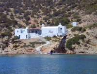
Sifnos
From CruisersWiki
m (→Port Vathi) |
Istioploos (Talk | contribs) (Re-format) |
||
| Line 1: | Line 1: | ||
==Sifnos== | ==Sifnos== | ||
| - | {| | + | {| class="infobox bordered" style="width: 33em; text-align: left; font-size: 85%;" |
|- | |- | ||
| - | | | + | | colspan="2" style="text-align:center; font-size: smaller;" | {{Small info}} (''Click links for more information'') |
| - | + | |- | |
| + | ! <center>[[image:World_icon.png]]</center> | ||
| + | | {{Coord|36|59.5|N|24|40.4|E|}} | ||
| + | |- | ||
| + | ! <center>[[image:Photo_icon.png]]</center> | ||
| + | | [http://www.panoramio.com/map/#lt=36.967175&ln=24.706879&z=5&k=0&a=1&tab=2 Photo gallery] | ||
| + | |- | ||
| + | ! <center>[[image:Chart_icon.png]]</center> | ||
| + | | [http://mapserver.mytopo.com/homepage/index.cfm?lat=36.97424685735442&lon=24.70656867387453&scale=150000&zoom=50&type=0&icon=0&width=498&height=498&searchscope=dom&CFID=17583484&CFTOKEN=79232580&scriptfile=http://mapserver.mytopo.com/homepage/index.cfm&latlontype=DMS Local chartlet] | ||
|} | |} | ||
| - | |||
| - | |||
| - | + | [[Image:Sifnos1.jpg|200px|thumb|left|A Potter in Sifnos<br/>''Click for larger view'']] | |
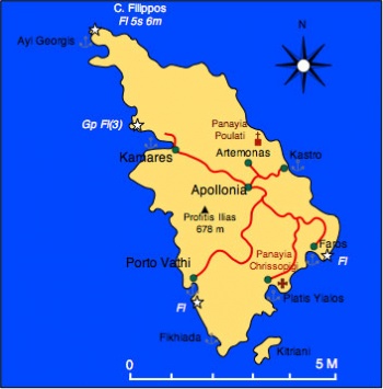
[http://www.vacation.net.gr/p/sifnos.html Sifnos] (Σίφνος) is windy and hilly island with an area of 74 km<sup>2</sup> and about 2000 inhabitants. Its highest peak, Profitis Ilias, is 678 m (2225 ft.) above sea level. Its west coast is barren but the east coast is greener and cultivated. The island is well known for its Cycladic architecture, it pottery, and it chefs. Several wealthy shipowner families come from Sifnos and maintain here beautiful houses. | [http://www.vacation.net.gr/p/sifnos.html Sifnos] (Σίφνος) is windy and hilly island with an area of 74 km<sup>2</sup> and about 2000 inhabitants. Its highest peak, Profitis Ilias, is 678 m (2225 ft.) above sea level. Its west coast is barren but the east coast is greener and cultivated. The island is well known for its Cycladic architecture, it pottery, and it chefs. Several wealthy shipowner families come from Sifnos and maintain here beautiful houses. | ||
| Line 15: | Line 21: | ||
In the middle ages most of the population lived near Kastro and were dominated by the [http://en.wikipedia.org/wiki/Republic_of_Venice Venetians] who were succeeded by the [http://en.wikipedia.org/wiki/Ottomans Ottomans] in 1617 AD. In the 17th century the Ottomans attempted to reopen the mines but were thwarted by French pirates supposedly hired by the islanders. After the [http://en.wikipedia.org/wiki/Greek_War_of_Independence Greek War of Independence] Sifnos joined Greece and a French interest reopened the mines and operated them until 1925. | In the middle ages most of the population lived near Kastro and were dominated by the [http://en.wikipedia.org/wiki/Republic_of_Venice Venetians] who were succeeded by the [http://en.wikipedia.org/wiki/Ottomans Ottomans] in 1617 AD. In the 17th century the Ottomans attempted to reopen the mines but were thwarted by French pirates supposedly hired by the islanders. After the [http://en.wikipedia.org/wiki/Greek_War_of_Independence Greek War of Independence] Sifnos joined Greece and a French interest reopened the mines and operated them until 1925. | ||
| - | + | ==Charts== | |
| - | [[Image: | + | [[Image:Sifnos_m.jpg|350px|thumb|right|Map of Sifnos<br/>''Click for larger view'']] |
| + | |||
;BA | ;BA | ||
:1037 Nisís Falkonera to Nísos Ios | :1037 Nisís Falkonera to Nísos Ios | ||
| Line 25: | Line 32: | ||
:415 Ydra to Sikinos | :415 Ydra to Sikinos | ||
| - | + | ==Radio Nets== | |
''Also see [[HF_Radio|Cruiser's Nets]]'' | ''Also see [[HF_Radio|Cruiser's Nets]]'' | ||
* Coast Guard - VHF channel 12, Tel. +30 2840 31 617 | * Coast Guard - VHF channel 12, Tel. +30 2840 31 617 | ||
* Olympia Radio- VHF channel 03 | * Olympia Radio- VHF channel 03 | ||
| - | ===Approach and Navigation | + | ==Weather== |
| + | ''See [[Aegean_Sea#Weather_and_Winds|Aegean Sea]]''. | ||
| + | |||
| + | ==Approach and Navigation== | ||
Approaches to the island are straightforward without navigational dangers, but | Approaches to the island are straightforward without navigational dangers, but | ||
<font color="red">Warning:</font> There can be very strong gusts when the ''meltemi'' blows, especially when entering [[#Kamares|Kamares]]. Reduce sail. | <font color="red">Warning:</font> There can be very strong gusts when the ''meltemi'' blows, especially when entering [[#Kamares|Kamares]]. Reduce sail. | ||
| - | + | ==Check-in facilities== | |
| + | None. | ||
| + | |||
| + | ==Ports and Popular Stops== | ||
There is only one port, [[#Kamares|Kamares]], but there are many attractive anchorages. | There is only one port, [[#Kamares|Kamares]], but there are many attractive anchorages. | ||
| - | ===Ports | + | ===Ports=== |
==== Kamares==== | ==== Kamares==== | ||
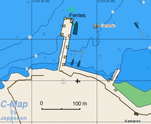
[[Image:Greece_Sifnos_Kamares_h.jpg|300px|thumb|right|Chart of Kamares - [http://mapserver.maptech.com/homepage/index.cfm?lat=36.99281352361051&lon=24.674771545077217&scale=10000&zoom=50&type=0&icon=0&width=498&height=498&searchscope=dom&CFID=1509264&CFTOKEN=22608242&scriptfile=http://mapserver.maptech.com/homepage/index.cfm&latlontype=DMS Chartlet]<br/>''Click for larger view'']] | [[Image:Greece_Sifnos_Kamares_h.jpg|300px|thumb|right|Chart of Kamares - [http://mapserver.maptech.com/homepage/index.cfm?lat=36.99281352361051&lon=24.674771545077217&scale=10000&zoom=50&type=0&icon=0&width=498&height=498&searchscope=dom&CFID=1509264&CFTOKEN=22608242&scriptfile=http://mapserver.maptech.com/homepage/index.cfm&latlontype=DMS Chartlet]<br/>''Click for larger view'']] | ||
| - | + | [[image:World_icon.png]] {{Coord|36|59.5|N|24|40.4|E|}}<br/> | |
Kamares (Καμάρες) is the only harbor in Sifnos. While it provides good shelter from the meltemi, it seems to have a constant swell, this swell is very uncomfortable and at times can be dangerous. At other times conditions are good, although a seabreeze sets into the inlet during the day and a land breeze out of it at night, so set your anchor accordingly. Go stern-to the quay, where there is space for around 6-8 yachts. The bottom is sand and weed and sometimes the holding is not too good. Use plenty of spring lines. Alternatively anchor off in 3-5 metres. If the swell becomes too strong it is best to go to [[#Port_Vathi|Port Vathi]] about 4 nM south. | Kamares (Καμάρες) is the only harbor in Sifnos. While it provides good shelter from the meltemi, it seems to have a constant swell, this swell is very uncomfortable and at times can be dangerous. At other times conditions are good, although a seabreeze sets into the inlet during the day and a land breeze out of it at night, so set your anchor accordingly. Go stern-to the quay, where there is space for around 6-8 yachts. The bottom is sand and weed and sometimes the holding is not too good. Use plenty of spring lines. Alternatively anchor off in 3-5 metres. If the swell becomes too strong it is best to go to [[#Port_Vathi|Port Vathi]] about 4 nM south. | ||
| Line 48: | Line 61: | ||
=====Last Visited & Details Checked (and updated here)===== | =====Last Visited & Details Checked (and updated here)===== | ||
''Date of member's visit to this Port/Stop & this page's details validated'': | ''Date of member's visit to this Port/Stop & this page's details validated'': | ||
| - | * June 1994 --[[User:Istioploos|Istioploos]] | + | * June 1994 --[[User:Istioploos|Istioploos]] [[Image:Greece_Icon.png]] |
| - | * May 2009 -- Athene of Lymington | + | * May 2009 --[[User:atheneoflymington|Athene of Lymington]] |
[[Image:Sifnos3.jpg|center|Fishing Boats at Kamares]] | [[Image:Sifnos3.jpg|center|Fishing Boats at Kamares]] | ||
| - | |||
| - | |||
| - | |||
===Anchorages=== | ===Anchorages=== | ||
====Port Vathi==== | ====Port Vathi==== | ||
| - | + | {| | |
| - | + | |valign="top"|[[image:World_icon.png]] {{Coord|36|55.7|N|24|41.2|E|}}<br/> | |
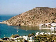
Port Vathi (Βαθύ) is definitely the safest anchorage in Sifnos, if gusty in the meltemi. I have been comfortable here while a force 8 gale raged for days. It is a pleasant setting, if somewhat remote from the rest of the island, with a nice sandy beach. Anchor off anywhere in 3-4 m, or do an anchor moor to the small mole at the N of the cove, where there is space for three yachts in depths of 2.5-3.0 meters (but limited mooring rings). The bottom is sand and provides good holding. A choice of good tavernas ashore and a very mini-market. | Port Vathi (Βαθύ) is definitely the safest anchorage in Sifnos, if gusty in the meltemi. I have been comfortable here while a force 8 gale raged for days. It is a pleasant setting, if somewhat remote from the rest of the island, with a nice sandy beach. Anchor off anywhere in 3-4 m, or do an anchor moor to the small mole at the N of the cove, where there is space for three yachts in depths of 2.5-3.0 meters (but limited mooring rings). The bottom is sand and provides good holding. A choice of good tavernas ashore and a very mini-market. | ||
=====Last Visited & Details Checked (and updated here)===== | =====Last Visited & Details Checked (and updated here)===== | ||
''Date of member's visit to this Port/Stop & this page's details validated'': | ''Date of member's visit to this Port/Stop & this page's details validated'': | ||
| - | * May 2001 --[[User:Istioploos|Istioploos]] | + | * May 2001 --[[User:Istioploos|Istioploos]] [[Image:Greece_Icon.png]] |
| - | * May 2009 -- Athene of Lymington | + | * May 2009 --[[User:atheneoflymington|Athene of Lymington]] |
| + | |||
| + | |valign="top"|[[Image:Greece_Sifnos_Vathi_h.jpg|300px|thumb|right|Chart of Port Vathi - [http://mapserver.maptech.com/homepage/index.cfm?lat=36.928030226899345&lon=24.686856066071925&scale=10000&zoom=50&type=0&icon=0&width=498&height=498&searchscope=dom&CFID=1509264&CFTOKEN=22608242&scriptfile=http://mapserver.maptech.com/homepage/index.cfm&latlontype=DMS Chartlet]<br/>''Click for larger view'']] | ||
| + | |} | ||
[[Image:Sifnos4.jpg|center|Port Vathi]] | [[Image:Sifnos4.jpg|center|Port Vathi]] | ||
====Ayi Georgis==== | ====Ayi Georgis==== | ||
| - | + | [[image:World_icon.png]] {{Coord|37|02|N|24|38.6|E|}}<br/> | |
Ayi Georgis or Ayios Georgis is near the NW tip of the island. It is a very narrow inlet which provides excellent shelter from the ''meltemi''. Also here is good place to buy ceramic ware directly from the shop. Unfortunately there is room for only one or two yachts. Anchor fore and aft at 8-10 m or take line to the little mole. | Ayi Georgis or Ayios Georgis is near the NW tip of the island. It is a very narrow inlet which provides excellent shelter from the ''meltemi''. Also here is good place to buy ceramic ware directly from the shop. Unfortunately there is room for only one or two yachts. Anchor fore and aft at 8-10 m or take line to the little mole. | ||
=====Last Visited & Details Checked (and updated here)===== | =====Last Visited & Details Checked (and updated here)===== | ||
''Date of member's visit to this Port/Stop & this page's details validated'': | ''Date of member's visit to this Port/Stop & this page's details validated'': | ||
| - | * June 1994 --[[User:Istioploos|Istioploos]] | + | * June 1994 --[[User:Istioploos|Istioploos]] [[Image:Greece_Icon.png]] |
* | * | ||
====Fikiadha==== | ====Fikiadha==== | ||
{| | {| | ||
| - | |valign="top"| | + | |valign="top"|[[image:World_icon.png]] {{Coord|36|54.4|N|24|42.25|E|}} |
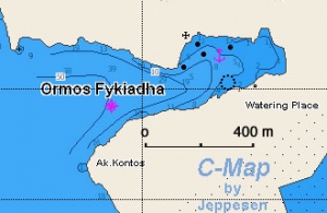
Fikiadha is pleasant and deserted inlet near the SW tip of the island. It offers good shelter for winds N through E to S. It is only open to the W. The bottom is sand and mud but it does not hold well uniformly. | Fikiadha is pleasant and deserted inlet near the SW tip of the island. It offers good shelter for winds N through E to S. It is only open to the W. The bottom is sand and mud but it does not hold well uniformly. | ||
=====Last Visited & Details Checked (and updated here)===== | =====Last Visited & Details Checked (and updated here)===== | ||
''Date of member's visit to this Port/Stop & this page's details validated'': | ''Date of member's visit to this Port/Stop & this page's details validated'': | ||
| - | * September 2000 --[[User:Istioploos|Istioploos]] | + | * September 2000 --[[User:Istioploos|Istioploos]] [[Image:Greece_Icon.png]] |
* | * | ||
| - | |||
| - | |||
|valign="top"|[[Image:Greece_Sifnos_Fikiadha_h.jpg|300px|thumb|right|Chart of Fikiadha - [http://mapserver.maptech.com/homepage/index.cfm?lat=36.906667&lon=24.704167&scale=24000&zoom=50&type=1 Chartlet]<br/>''Click for larger view'']] | |valign="top"|[[Image:Greece_Sifnos_Fikiadha_h.jpg|300px|thumb|right|Chart of Fikiadha - [http://mapserver.maptech.com/homepage/index.cfm?lat=36.906667&lon=24.704167&scale=24000&zoom=50&type=1 Chartlet]<br/>''Click for larger view'']] | ||
|} | |} | ||
| + | |||
| + | [[Image:Sifnos_Fikiada.jpg|200px|thumb|center|The one and only House at Fikiada<br/>''Click for larger view'']] | ||
====Platis Yialos==== | ====Platis Yialos==== | ||
[[Image:Greece_Sifnos_P_Yialos_r.jpg|300px|thumb|right|Chart of Platis Yialos - [http://mapserver.maptech.com/homepage/index.cfm?lat=36.92322351722951&lon=24.73732476106363&scale=20000&zoom=50&type=0&icon=0&width=498&height=498&searchscope=dom&CFID=1509264&CFTOKEN=22608242&scriptfile=http://mapserver.maptech.com/homepage/index.cfm&latlontype=DMS Chartlet]<br/>''Click for larger view'']] | [[Image:Greece_Sifnos_P_Yialos_r.jpg|300px|thumb|right|Chart of Platis Yialos - [http://mapserver.maptech.com/homepage/index.cfm?lat=36.92322351722951&lon=24.73732476106363&scale=20000&zoom=50&type=0&icon=0&width=498&height=498&searchscope=dom&CFID=1509264&CFTOKEN=22608242&scriptfile=http://mapserver.maptech.com/homepage/index.cfm&latlontype=DMS Chartlet]<br/>''Click for larger view'']] | ||
| - | + | [[image:World_icon.png]] {{Coord|36|55.8|N|24|43.7|E|}}<br/> | |
Platis Yialos (Πλατύς Γιαλός) is a bay at SE coast with a number of restaurants and hotels. It provides good shelter from the ''meltemi'' but it is subject to very strong gusts. Anchor near the NE corner in 5-7 m. The bottom is sand and rock but the holding is not good everywhere. | Platis Yialos (Πλατύς Γιαλός) is a bay at SE coast with a number of restaurants and hotels. It provides good shelter from the ''meltemi'' but it is subject to very strong gusts. Anchor near the NE corner in 5-7 m. The bottom is sand and rock but the holding is not good everywhere. | ||
=====Last Visited & Details Checked (and updated here)===== | =====Last Visited & Details Checked (and updated here)===== | ||
''Date of member's visit to this Port/Stop & this page's details validated'': | ''Date of member's visit to this Port/Stop & this page's details validated'': | ||
| - | * September 2000 --[[User:Istioploos|Istioploos]] | + | * September 2000 --[[User:Istioploos|Istioploos]] [[Image:Greece_Icon.png]] |
* | * | ||
====Faros==== | ====Faros==== | ||
| - | + | [[image:World_icon.png]] {{Coord|36|56.5|N|24|45|E|}} - [http://mapserver.maptech.com/homepage/index.cfm?lat=36.9405408586327&lon=24.757064274595177&scale=10000&zoom=50&type=0&icon=0&width=498&height=498&searchscope=dom&CFID=1509264&CFTOKEN=22608242&scriptfile=http://mapserver.maptech.com/homepage/index.cfm&latlontype=DMS Chartlet]<br/> | |
Faros or Pharos is a bay on the SE side of Sifnos which provides good shelter from the ''meltemi''. You can anchor either to the S of Cape Petalos or off the village. | Faros or Pharos is a bay on the SE side of Sifnos which provides good shelter from the ''meltemi''. You can anchor either to the S of Cape Petalos or off the village. | ||
====Kastro==== | ====Kastro==== | ||
| - | + | [[image:World_icon.png]] {{Coord|36|58.5|N|24|44.8|E|}} - [http://mapserver.maptech.com/homepage/index.cfm?lat=36.975&lon=24.746667&scale=24000&zoom=50&type=1 Chartlet]<br/> | |
Kastro is open cove on the E side of the island. It suitable for anchorage only in calm weather and is exposed to the ''meltemi''. | Kastro is open cove on the E side of the island. It suitable for anchorage only in calm weather and is exposed to the ''meltemi''. | ||
| - | === | + | ==Marinas & Yacht Clubs== |
| - | + | None. | |
| + | |||
| + | ==Yacht Services and Repairs== | ||
| + | ====Marine Stores==== | ||
| + | None. | ||
| + | |||
| + | ====Yacht Services/Repairs/Yards==== | ||
| + | None. | ||
| + | |||
| + | ====Fuel, Water, & Electricity==== | ||
| + | ; Fuel | ||
| + | : Arrangements can be made for a delivery at [[#Kamares|Kamares]] by calling Mr. Stefanos Komis at 31 347 or 31 777 | ||
| + | ; Water | ||
| + | : Limited water at the quay at [[#Kamares|Kamares]] | ||
| + | ; Electricity | ||
| + | : N/A (Not Available) | ||
| + | |||
| + | ==Offshore Islands== | ||
| + | * [[Serifos]] | ||
| + | * [[Milos]] | ||
| + | |||
| + | ==Tourism and Things to do Ashore== | ||
| + | {| class="wikitable" align=right | ||
| + | |- | ||
| + | |[[Image:Sifnos2.jpg|200px]]<br/><small>A Dovecote<br/>''Click for larger view''</small> | ||
| + | |- | ||
| + | |[[Image:Sifnos6.jpg|200px]]<br/><small>A Chapel in Sifnos</small> | ||
| + | |- | ||
| + | |[[Image:Sifnos5.jpg|200px]]<br/><small>Churches in Sifnos</small> | ||
| + | |} | ||
| - | ===Tourism | + | ===Tourism=== |
The capital of the island, Apollonia (Απολλονία), is most definitely worth visiting. It is lovely [http://en.wikipedia.org/wiki/Cyclades Cycladic] town built on a cliff with lime-washed white houses and colorful bougainvillea on their walls. There is a ''Museum of Popular Arts and Folklore'' (opens at 10 AM) which houses some old photographs, some books, embroideries, costumes, and cooking artifacts from the 19th century. The most interesting is an exhibit of special Easter breads, all in very fanciful shapes. There is regular bus service from [[#Kamares|Kamares]] and [[#Port_Vathi|Port Vathi]]. | The capital of the island, Apollonia (Απολλονία), is most definitely worth visiting. It is lovely [http://en.wikipedia.org/wiki/Cyclades Cycladic] town built on a cliff with lime-washed white houses and colorful bougainvillea on their walls. There is a ''Museum of Popular Arts and Folklore'' (opens at 10 AM) which houses some old photographs, some books, embroideries, costumes, and cooking artifacts from the 19th century. The most interesting is an exhibit of special Easter breads, all in very fanciful shapes. There is regular bus service from [[#Kamares|Kamares]] and [[#Port_Vathi|Port Vathi]]. | ||
| Line 127: | Line 169: | ||
Near the islands's peak is the 8th century ''Monastery of Profitis Ilias'', with thick walls and a network of [http://en.wikipedia.org/wiki/Catacombs catacombs]. The most famous monastery of the island, however, is ''Panayia Chrissopigi'', built in 1650 AD on a rocky slope. There is a charming story associated with the monastery. Two lovely damsels were surprised by pirates while napping with the church. They ran away, the pirates pursuing. While running they prayed to the Virgin to protect them. The cape split into two thus cutting off the pirates. | Near the islands's peak is the 8th century ''Monastery of Profitis Ilias'', with thick walls and a network of [http://en.wikipedia.org/wiki/Catacombs catacombs]. The most famous monastery of the island, however, is ''Panayia Chrissopigi'', built in 1650 AD on a rocky slope. There is a charming story associated with the monastery. Two lovely damsels were surprised by pirates while napping with the church. They ran away, the pirates pursuing. While running they prayed to the Virgin to protect them. The cape split into two thus cutting off the pirates. | ||
| - | + | ===Grocery & Supply Stores=== | |
| - | + | ||
| - | + | ||
| - | + | ||
| - | + | ||
| - | + | ||
| - | + | ||
| - | + | ||
| - | + | ||
| - | + | ||
| - | + | ||
| - | + | ||
| - | + | ||
| - | + | ||
| - | + | ||
Several good stores in [[#Kamares|Kamares]] | Several good stores in [[#Kamares|Kamares]] | ||
| Line 150: | Line 178: | ||
* At [[#Port_Vathi|Port Vathi]] the ''Tjikali'' has very good food | * At [[#Port_Vathi|Port Vathi]] the ''Tjikali'' has very good food | ||
* Near Panayia Chrissopigi the ''Lembesi'' restaurant serves good food | * Near Panayia Chrissopigi the ''Lembesi'' restaurant serves good food | ||
| + | |||
| + | ===Internet/WiFi=== | ||
| + | In Internet cafés. | ||
| + | |||
| + | ===Laundry=== | ||
| + | ? | ||
===Motorbike & Car Rentals=== | ===Motorbike & Car Rentals=== | ||
? | ? | ||
| - | === | + | ===Garbage Disposal=== |
| - | + | There are bins around the harbor and in several anchorages. | |
| - | + | ||
| - | + | ||
| - | + | ||
===Transportation=== | ===Transportation=== | ||
| Line 165: | Line 196: | ||
Taxis in the island can be arranged by calling Mr. Stefanos Komis at +30 2840 31 347 or +30 2840 31 777. | Taxis in the island can be arranged by calling Mr. Stefanos Komis at +30 2840 31 347 or +30 2840 31 777. | ||
| - | == | + | ==Routes/Passages To/From== |
| - | + | * [[Passages between Athens Region and Rhodes - Marmaris]] | |
| + | * [[Cruising the Cyclades Islands]] | ||
| - | + | ==Cruiser's Friends== | |
Contact details of "Cruiser's Friends" that can be contacted for local information or assistance. | Contact details of "Cruiser's Friends" that can be contacted for local information or assistance. | ||
| - | + | ==Forum Discussions== | |
List links to discussion threads on the Cruiser Log Forum | List links to discussion threads on the Cruiser Log Forum | ||
* | * | ||
| Line 177: | Line 209: | ||
* | * | ||
| - | + | ==External Links== | |
* [http://www.vacation.net.gr/p/sifnos.html Sifnos] (Wikipedia) | * [http://www.vacation.net.gr/p/sifnos.html Sifnos] (Wikipedia) | ||
* | * | ||
* | * | ||
| - | == | + | ==References & Publications== |
| - | + | See [[Greece#References_&_Publications|Greece]]. | |
| - | + | ==Last Visited & Details Checked (and updated here)== | |
See individual ports in this page. | See individual ports in this page. | ||
| + | |||
| + | ==Personal Notes== | ||
| + | Personal experiences? | ||
Revision as of 14:38, 8 December 2009
Sifnos
| | |
| | 36°59.5′N, 24°40.4′E |
|---|---|
| | Photo gallery |
| | Local chartlet |
Sifnos (Σίφνος) is windy and hilly island with an area of 74 km2 and about 2000 inhabitants. Its highest peak, Profitis Ilias, is 678 m (2225 ft.) above sea level. Its west coast is barren but the east coast is greener and cultivated. The island is well known for its Cycladic architecture, it pottery, and it chefs. Several wealthy shipowner families come from Sifnos and maintain here beautiful houses.
In antiquity, Sifnos known as Meropia, was famous for its wealth from its gold and silver mines. This mines go back to the 3rd millennium BC and are the oldest mines discovered in Europe. The earliest inhabitants appear to have been Phoenicians who were replaced by Minoans who founded Minoa near the modern town of Apollonia, the island's capital. The Minoans were replaced by Ionian Greeks who lived near Ayios Andreas. The Meripians were not only very wealthy but were also greedy. They were discovered to have cheated the Oracle of Delphi by contributing instead of pure gold, lead eggs just gilded with gold. This discovery gave a good excuse, the anger of Apollo, to Polycrates of Samos to invade and plunder the island. After this the island declined.
In the middle ages most of the population lived near Kastro and were dominated by the Venetians who were succeeded by the Ottomans in 1617 AD. In the 17th century the Ottomans attempted to reopen the mines but were thwarted by French pirates supposedly hired by the islanders. After the Greek War of Independence Sifnos joined Greece and a French interest reopened the mines and operated them until 1925.
Charts
- BA
- 1037 Nisís Falkonera to Nísos Ios
- Imray-Tetra
- G33 Southern Cyclades
- Greek
- 41 Cavos Maleas to Cavos Kimis
- 415 Ydra to Sikinos
Radio Nets
Also see Cruiser's Nets
- Coast Guard - VHF channel 12, Tel. +30 2840 31 617
- Olympia Radio- VHF channel 03
Weather
See Aegean Sea.
Approaches to the island are straightforward without navigational dangers, but
Warning: There can be very strong gusts when the meltemi blows, especially when entering Kamares. Reduce sail.
Check-in facilities
None.
Ports and Popular Stops
There is only one port, Kamares, but there are many attractive anchorages.
Ports
Kamares
![]() 36°59.5′N, 24°40.4′E
36°59.5′N, 24°40.4′E
Kamares (Καμάρες) is the only harbor in Sifnos. While it provides good shelter from the meltemi, it seems to have a constant swell, this swell is very uncomfortable and at times can be dangerous. At other times conditions are good, although a seabreeze sets into the inlet during the day and a land breeze out of it at night, so set your anchor accordingly. Go stern-to the quay, where there is space for around 6-8 yachts. The bottom is sand and weed and sometimes the holding is not too good. Use plenty of spring lines. Alternatively anchor off in 3-5 metres. If the swell becomes too strong it is best to go to Port Vathi about 4 nM south.
Caution: Do not enter the bay under sail. The gust are very strong and can be dangerous.
Last Visited & Details Checked (and updated here)
Date of member's visit to this Port/Stop & this page's details validated:
- June 1994 --Istioploos

- May 2009 --Athene of Lymington
Anchorages
Port Vathi
Port Vathi (Βαθύ) is definitely the safest anchorage in Sifnos, if gusty in the meltemi. I have been comfortable here while a force 8 gale raged for days. It is a pleasant setting, if somewhat remote from the rest of the island, with a nice sandy beach. Anchor off anywhere in 3-4 m, or do an anchor moor to the small mole at the N of the cove, where there is space for three yachts in depths of 2.5-3.0 meters (but limited mooring rings). The bottom is sand and provides good holding. A choice of good tavernas ashore and a very mini-market. Last Visited & Details Checked (and updated here)Date of member's visit to this Port/Stop & this page's details validated:
|
Ayi Georgis
![]() 37°02′N, 24°38.6′E
37°02′N, 24°38.6′E
Ayi Georgis or Ayios Georgis is near the NW tip of the island. It is a very narrow inlet which provides excellent shelter from the meltemi. Also here is good place to buy ceramic ware directly from the shop. Unfortunately there is room for only one or two yachts. Anchor fore and aft at 8-10 m or take line to the little mole.
Last Visited & Details Checked (and updated here)
Date of member's visit to this Port/Stop & this page's details validated:
- June 1994 --Istioploos

Fikiadha
Fikiadha is pleasant and deserted inlet near the SW tip of the island. It offers good shelter for winds N through E to S. It is only open to the W. The bottom is sand and mud but it does not hold well uniformly. Last Visited & Details Checked (and updated here)Date of member's visit to this Port/Stop & this page's details validated:
|
Platis Yialos
![]() 36°55.8′N, 24°43.7′E
36°55.8′N, 24°43.7′E
Platis Yialos (Πλατύς Γιαλός) is a bay at SE coast with a number of restaurants and hotels. It provides good shelter from the meltemi but it is subject to very strong gusts. Anchor near the NE corner in 5-7 m. The bottom is sand and rock but the holding is not good everywhere.
Last Visited & Details Checked (and updated here)
Date of member's visit to this Port/Stop & this page's details validated:
- September 2000 --Istioploos

Faros
![]() 36°56.5′N, 24°45′E - Chartlet
36°56.5′N, 24°45′E - Chartlet
Faros or Pharos is a bay on the SE side of Sifnos which provides good shelter from the meltemi. You can anchor either to the S of Cape Petalos or off the village.
Kastro
![]() 36°58.5′N, 24°44.8′E - Chartlet
36°58.5′N, 24°44.8′E - Chartlet
Kastro is open cove on the E side of the island. It suitable for anchorage only in calm weather and is exposed to the meltemi.
Marinas & Yacht Clubs
None.
Yacht Services and Repairs
Marine Stores
None.
Yacht Services/Repairs/Yards
None.
Fuel, Water, & Electricity
- Fuel
- Arrangements can be made for a delivery at Kamares by calling Mr. Stefanos Komis at 31 347 or 31 777
- Water
- Limited water at the quay at Kamares
- Electricity
- N/A (Not Available)
Offshore Islands
Tourism and Things to do Ashore
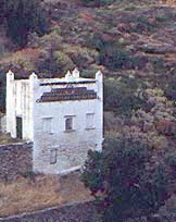 A Dovecote Click for larger view |
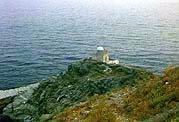 A Chapel in Sifnos |
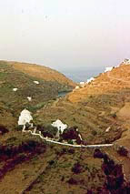 Churches in Sifnos |
Tourism
The capital of the island, Apollonia (Απολλονία), is most definitely worth visiting. It is lovely Cycladic town built on a cliff with lime-washed white houses and colorful bougainvillea on their walls. There is a Museum of Popular Arts and Folklore (opens at 10 AM) which houses some old photographs, some books, embroideries, costumes, and cooking artifacts from the 19th century. The most interesting is an exhibit of special Easter breads, all in very fanciful shapes. There is regular bus service from Kamares and Port Vathi.
About a mile from Apollonia is the town of Artemonas with many neo-classical villas belonging to the rich shipowners. The church of Kochi occupies the site of the ancient temple to Artemis. Next to it is the little 17th century church of Ayios Georgios tou Aféndi with some fine icons.
Near Kamares there is the Cavern of the Nymphs which was used as a place of worship around the end of 6th century BC.
At Ayios Andreas there is the excavated 12 century BC Mycenean Acropolis.
The Venetian town of Kastro with its still standing Byzantine walls is definitely worth a visit. Nearby are the ruins of the Classical acropolis. There is also here an Archaelogical Museum, housed in the old Venetian church of St. Anthony of Padua.
Near the islands's peak is the 8th century Monastery of Profitis Ilias, with thick walls and a network of catacombs. The most famous monastery of the island, however, is Panayia Chrissopigi, built in 1650 AD on a rocky slope. There is a charming story associated with the monastery. Two lovely damsels were surprised by pirates while napping with the church. They ran away, the pirates pursuing. While running they prayed to the Virgin to protect them. The cape split into two thus cutting off the pirates.
Grocery & Supply Stores
Several good stores in Kamares
Eateries
Sifnian food is renowned throughout Greece.
- There are many restaurants in Kamares
- There is an excellent spread of mezedes (appetizers) at Margarita in Apollonia, also at night the Argo is highly recommended
- At Port Vathi the Tjikali has very good food
- Near Panayia Chrissopigi the Lembesi restaurant serves good food
Internet/WiFi
In Internet cafés.
Laundry
?
Motorbike & Car Rentals
?
Garbage Disposal
There are bins around the harbor and in several anchorages.
Transportation
In the summer there are daily ferries to Rafina and Piraeus.
Taxis in the island can be arranged by calling Mr. Stefanos Komis at +30 2840 31 347 or +30 2840 31 777.
Routes/Passages To/From
Cruiser's Friends
Contact details of "Cruiser's Friends" that can be contacted for local information or assistance.
Forum Discussions
List links to discussion threads on the Cruiser Log Forum
External Links
- Sifnos (Wikipedia)
References & Publications
See Greece.
Last Visited & Details Checked (and updated here)
See individual ports in this page.
Personal Notes
Personal experiences?
| |
|---|
| | HOMEPAGE | Wiki Contents | Mediterranean | Aegean Sea | Greece | Sifnos | |
.

