Gulf of Gokova
From CruisersWiki
Istioploos (Talk | contribs) m (Costetic) |
Istioploos (Talk | contribs) (Poi's) |
||
| Line 43: | Line 43: | ||
===Anchorages=== | ===Anchorages=== | ||
| - | + | {{Image right| Turkey_Gokova_Degirmen_S.jpg| Satellite View of Degirmen Bükü}} | |
| - | {{ | + | {{Poi |lat= 36.91271 |lon=28.16285 | type= anchorage |name= Degirmen Bükü |zoom= 15 |
| - | | name= Degirmen Bükü | + | | text= Degirmen Bükü or Deremen or English Harbor is a large, magnificent, heavily wooded bay with many anchoring possibilities. |
| - | | | + | |
| - | | | + | |
| - | + | ||
| - | + | ||
| - | Degirmen Bükü or Deremen or English Harbor is a large, magnificent, heavily wooded bay with many anchoring possibilities. | + | |
| - | The actual English Harbor (Ingilizi Liman) is shown on the Satellite view. | + | The actual English Harbor (Ingilizi Liman) is shown on the Satellite view.}} |
| - | + | ||
| - | + | ||
| - | + | ||
| - | + | ||
| - | + | ||
| - | + | ||
| - | + | ||
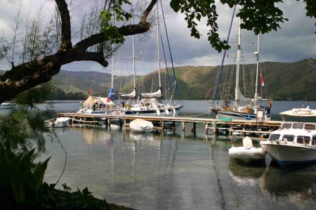
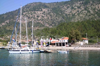
| - | {{Image center|Degirmen.jpeg |Degirmen Bükü restaurant pontoon | + | {{Image center|Degirmen.jpeg |Degirmen Bükü restaurant pontoon |450px }} |
| + | {{Image right| Turkey Gokova Sogut S.jpg| Satellite View of Sögüt}} | ||
| + | {{Poi |36|56.4|N|28|11.4|E|| type= anchorage |name= Sögüt |zoom= 15 | ||
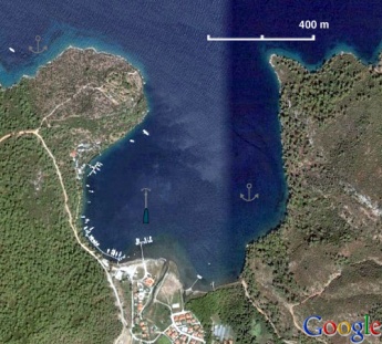
| + | | text= Sögüt is a large bay that provides an all around shelter. There are three mooring possibilities. The Yacht Club, the" town quay " (really just a wooden pontoon) and the restaurant pontoon. Or you can anchor off. Anchor in 12-14 m. The restaurant also provides excellent water. }} | ||
| - | |||
| - | |||
| - | |||
| - | |||
| - | |||
| - | |||
| - | |||
| - | |||
| - | |||
| - | |||
| - | |||
| - | |||
| - | |||
| - | |||
{{hold vertical}} | {{hold vertical}} | ||
| - | + | {{Image right| Turkey Gokova Akbuk h.jpg| Chart of Akbük Liman}} | |
| - | {{ | + | {{Poi |37|01.9|N|28|06.3|E| | type= anchorage |name= Akbük Liman |zoom= 15 |
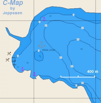
| - | | name= Akbük Liman | + | | text= When we were last in Akbük Liman there was an excellent restaurant. }} |
| - | | | + | |
| - | | | + | |
| - | + | ||
| - | + | ||
| - | When we were last in Akbük Liman there was an excellent restaurant. | + | |
| - | |||
| - | |||
| - | |||
| - | |||
{{hold vertical}} | {{hold vertical}} | ||
| - | + | {{Image right| Cokertme.jpeg| Restaurant pontoon, Çökertme}} | |
| - | {{ | + | {{Poi |36|59.8|N|27|47.5|E| | type= anchorage |name= Çökertme |zoom= 15 |
| - | | name= Çökertme | + | | text= Çökertme also known as Fesiliyen Koyu or Vasilika. It is an attractive cove but it is subject to strong gusts. Anchor in 2-5 m. The bottom is sand and weed and there could be a problem with holding, so take a line ashore. Alternatively, pick up a laid mooring on one of the three restaurant pontoons. With an onshore southerly it is best to anchor off in the western cove, as big incoming waves make the restaurant pontoons very uncomfortable. |
| - | | | + | |
| - | | | + | |
| - | + | ||
| - | + | ||
| - | Çökertme also known as Fesiliyen Koyu or Vasilika. It is an attractive cove but it is subject to strong gusts. Anchor in 2-5 m. The bottom is sand and weed and there could be a problem with holding, so take a line ashore. Alternatively, pick up a laid mooring on one of the three restaurant pontoons. With an onshore southerly it is best to anchor off in the western cove, as big incoming waves make the restaurant pontoons very uncomfortable. | + | |
| - | When we were there there was a very basic eatery presided by the colorful "Captain Ibrahim" who looked straight out of pirate movie. | + | When we were there there was a very basic eatery presided by the colorful "Captain Ibrahim" who looked straight out of pirate movie. }} |
| - | |||
| - | |||
| - | |||
| - | |||
| - | |||
| - | |||
{{hold vertical}} | {{hold vertical}} | ||
==Offshore Islands== | ==Offshore Islands== | ||
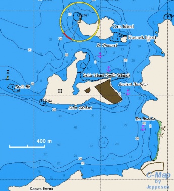
| - | + | {{Image right| Turkey_Gokova_Sehir_m.jpg| Chart of Sehir Adalari}} | |
| - | {{ | + | {{Poi |36|59.7|N|28|12.5|E| | type= island |name= Sehir Adalari |zoom= 15 |
| - | | name= Sehir Adalari | + | | text= Sehir Adalari or Shehir Oghlan or Snake and Castle Island was known in antiquity as Kedreai. The beach on west of the island was known as "Cleopatra's Beach." It was believed to have been made with sand transported from Egypt by [http://en.wikipedia.org/wiki/Mark_Antony Mark Anthony] especially for [http://en.wikipedia.org/wiki/Cleopatra_VII Cleopatra]. Today there are many ruins and walking around the island is a pleasure. |
| - | | | + | |
| - | | | + | |
| - | + | ||
| - | + | ||
| - | Sehir Adalari or Shehir Oghlan or Snake and Castle Island was known in antiquity as Kedreai. The beach on west of the island was known as "Cleopatra's Beach." It was believed to have been made with sand transported from Egypt by [http://en.wikipedia.org/wiki/Mark_Antony Mark Anthony] especially for [http://en.wikipedia.org/wiki/Cleopatra_VII Cleopatra]. Today there are many ruins and walking around the island is a pleasure. | + | |
Anchor on the E side in 5-10 m in the middle of the bay or in shallower water and take a line ashore. The bottom is sand and weed and provides good holding especially if you avoid the weed. | Anchor on the E side in 5-10 m in the middle of the bay or in shallower water and take a line ashore. The bottom is sand and weed and provides good holding especially if you avoid the weed. | ||
| Line 131: | Line 83: | ||
{{Danger}} Watch out for the submerged ancient mole in the NE point. | {{Danger}} Watch out for the submerged ancient mole in the NE point. | ||
| - | {{Warning}} The wind direction is liable to change in the evening from N to NE. | + | {{Warning}} The wind direction is liable to change in the evening from N to NE. }} |
| - | + | ||
| - | + | ||
| - | + | ||
| - | + | ||
| - | + | ||
| - | + | ||
| - | + | ||
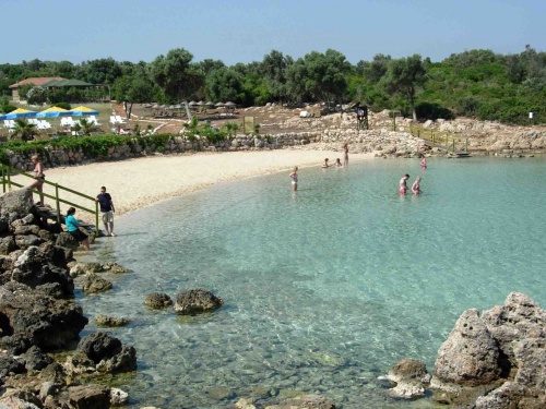
{{Image center|Sehir.jpeg |Cleopatra's Beach - ''Click for larger view'' |500px }} | {{Image center|Sehir.jpeg |Cleopatra's Beach - ''Click for larger view'' |500px }} | ||
| - | {{Poi |36 | + | {{Poi |lat= 36.97878386157901 |lon= 27.57744920133043 | type= island| name= Orak Island Region |zoom= 15 |
| - | | text= There are several anchoring opportunities here. It is a nice place not too far from [[Bodrum]]. You can anchor here. But, it is deep and there can be strong cross winds. | + | | text= There are several anchoring opportunities here. It is a nice place not too far from [[Bodrum]]. You can anchor here. But, it is deep and there can be strong cross winds. }} |
| - | + | ||
| - | + | ||
| - | + | ||
| - | + | ||
| - | + | ||
| - | }} | + | |
==Yacht Repairs and Services== | ==Yacht Repairs and Services== | ||
| Line 217: | Line 156: | ||
====Last Visited & Details Checked (and updated here)==== | ====Last Visited & Details Checked (and updated here)==== | ||
| - | + | * July 1985 ([[#Degirmen_Bükü|Degirmen Bükü]], [[#Sögüt|Sögüt]], [[#Akbük_Liman|Akbük Liman]], [[#Çökertme|Çökertme]], [[#Sehir_Adalari|Sehir Adalari]]) {{Istioploos2}} | |
| - | + | * August 2004 ([[#Orak Island Region|Orak Island Region]]) {{Istioploos2}} | |
| + | * May 2007 ([[#Çökertme|Çökertme]], [[#Sehir_Adalari|Sehir Adalari]]) --[[User:Atheneoflymington|Atheneoflymington]] 20:06, 11 January 2010 (UTC) | ||
| + | * July 2007 ([[#Degirmen_Bükü|Degirmen Bükü]]) --[[User:Atheneoflymington|Atheneoflymington]] 19:54, 11 January 2010 (UTC) | ||
| + | * May 2012 ([[#Degirmen_Bükü|Degirmen Bükü]], [[#Sögüt|Sögüt]], [[#Çökertme|Çökertme]], [[#Sehir_Adalari|Sehir Adalari]]) --[[User:Vigdis|Vigdis]] | ||
| + | * | ||
{{Page useable}} | {{Page useable}} | ||
Revision as of 19:12, 21 March 2016
The Gulf of Gökova has many anchorages but it can be very crowded with charter boats and gulets from Bodrum.
Charts
- BA
- 1055 Rhodes Channel and Gökova Körfezi
- Imray-Tetra
- G35 Dodecanese and Coast of Turkey
- NIMA
- 54400 Samos to Rodhos
- Turkey
- 311 Bodrum Boğazı - Marmaris
- 3111 C) Değirmen Bükü
- Greek
- 451 Leros to Rhodos
Radio Nets
Also see World Cruiser's Nets.
Local Weather
See Turkey.
Approach to the gulf is straightforward. The meltemi as you move into the gulf weakens and comes from the west.
Check-in facilities (for Customs and Immigration)
Ports of entry in the gulf are Bodrum and Turgutreis Marina.
Berthing Options
Ports
Marinas & Yacht Clubs
Anchorages
Degirmen Bükü
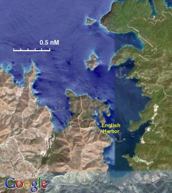
Degirmen Bükü or Deremen or English Harbor is a large, magnificent, heavily wooded bay with many anchoring possibilities.
The actual English Harbor (Ingilizi Liman) is shown on the Satellite view.Sögüt
Akbük Liman
Çökertme
Çökertme also known as Fesiliyen Koyu or Vasilika. It is an attractive cove but it is subject to strong gusts. Anchor in 2-5 m. The bottom is sand and weed and there could be a problem with holding, so take a line ashore. Alternatively, pick up a laid mooring on one of the three restaurant pontoons. With an onshore southerly it is best to anchor off in the western cove, as big incoming waves make the restaurant pontoons very uncomfortable.
When we were there there was a very basic eatery presided by the colorful "Captain Ibrahim" who looked straight out of pirate movie.Offshore Islands
Sehir Adalari
Sehir Adalari or Shehir Oghlan or Snake and Castle Island was known in antiquity as Kedreai. The beach on west of the island was known as "Cleopatra's Beach." It was believed to have been made with sand transported from Egypt by Mark Anthony especially for Cleopatra. Today there are many ruins and walking around the island is a pleasure.
Anchor on the E side in 5-10 m in the middle of the bay or in shallower water and take a line ashore. The bottom is sand and weed and provides good holding especially if you avoid the weed.
Visiting the island is controlled by ticket and you are not allowed to visit at night.
There is a restaurant and snack bar ashore.
Danger: Watch out for the submerged ancient mole in the NE point.
Warning: The wind direction is liable to change in the evening from N to NE.Orak Island Region
Yacht Repairs and Services
Marine Stores
None.
Repairs/Yards
None.
Fuel, Water, & Electricity
- Fuel
- N/A (Not Available)
- Water
- In Sögüt
- Electricity
- N/A
Things to do Ashore
Tourism
Visit Bodrum.
Grocery Stores
N/A.
Eateries
- In Sögüt
- In Akbük Liman
- In Çökertme at Captain Ibrahim
- In Sehir Adalari
Internet/WiFi
N/A.
Laundry
N/A.
Motorbike & Car Rentals
N/A.
Garbage Disposal
N/A (Not Available).
Transportation
From Bodrum.
Routes/Passages To/From
Cruiser's Friends
Contact details of "Cruiser's Friends" that can be contacted for local information or assistance.
Forum Discussions
List links to discussion threads on partnering forums. (see link for requirements)
External Links
- Gulf of Gökova at the Wikipedia
References & Publications
See Turkey.
Personal Notes
Personal experiences?
Last Visited & Details Checked (and updated here)
- July 1985 (Degirmen Bükü, Sögüt, Akbük Liman, Çökertme, Sehir Adalari) --Istioploos

 Travels with S/Y Thetis
- August 2004 (Orak Island Region) --Istioploos

 Travels with S/Y Thetis
- May 2007 (Çökertme, Sehir Adalari) --Atheneoflymington 20:06, 11 January 2010 (UTC)
- July 2007 (Degirmen Bükü) --Atheneoflymington 19:54, 11 January 2010 (UTC)
- May 2012 (Degirmen Bükü, Sögüt, Çökertme, Sehir Adalari) --Vigdis
| This is a usable page of the cruising guide. However, please contribute if you can to help it grow further. Click on Comments to add your personal notes on this page or to discuss its contents. Alternatively, if you feel confident to edit the page, click on the edit tab at the top and enter your changes directly. |
| |
|---|
|
Names: Istioploos, Athene of Lymington, Vigdis |

