Sikias
From CruisersWiki
m (→Anchorages) |
Istioploos (Talk | contribs) m (Added contributors) |
||
| Line 13: | Line 13: | ||
| [http://mapserver.maptech.com/homepage/index.cfm?lat=40.035667&lon=23.996167&scale=300000&zoom=100&type=0&icon=0&searchscope=dom&CFID=1509264&CFTOKEN=22608242&scriptfile=http://mapserver.maptech.com/homepage/index.cfm&latlontype=DMS Local chartlet] | | [http://mapserver.maptech.com/homepage/index.cfm?lat=40.035667&lon=23.996167&scale=300000&zoom=100&type=0&icon=0&searchscope=dom&CFID=1509264&CFTOKEN=22608242&scriptfile=http://mapserver.maptech.com/homepage/index.cfm&latlontype=DMS Local chartlet] | ||
|} | |} | ||
| - | + | {{TOCleft}} | |
| - | + | ||
Sikias or Sykias (Συκιάς) also refered to as Skala Sikias is a wonderful cove well protected frequented by local fishermen. | Sikias or Sykias (Συκιάς) also refered to as Skala Sikias is a wonderful cove well protected frequented by local fishermen. | ||
| - | |||
==Charts== | ==Charts== | ||
[[Image:Greece_Sikias_m.jpg|350px|thumb|right|Chart of Sikias<br/>''Click for larger view'']] | [[Image:Greece_Sikias_m.jpg|350px|thumb|right|Chart of Sikias<br/>''Click for larger view'']] | ||
| Line 50: | Line 48: | ||
==Marinas & Yacht Clubs== | ==Marinas & Yacht Clubs== | ||
None. | None. | ||
| + | <div style="clear: both;"></div> | ||
==Anchorages== | ==Anchorages== | ||
| - | [[Image:Yachtbillabong_Sikias_Mt_Athos_110705.jpg|300px|thumb|right| Mt Athos at dawn from the anchorage at the head of the bay | + | [[Image:Yachtbillabong_Sikias_Mt_Athos_110705.jpg|300px|thumb|right| Mt Athos at dawn from the anchorage at the head of the bay<br />''Click for larger view'']] |
There are a number of places to anchor around the bay, with varying protection, as shown on the diagram. | There are a number of places to anchor around the bay, with varying protection, as shown on the diagram. | ||
| Line 83: | Line 82: | ||
===Grocery & Supply Stores=== | ===Grocery & Supply Stores=== | ||
| - | None in Sikias. In Sarti | + | None in Sikias. In Sarti ([[image:World_icon.png]] {{Coord|40|5.5041|N|23|58.7047|E|}}), about 5 miles north, there is at least one supermarket and bakery together.. It is possible to anchor off the Sarti beach and dinghy ashore here. Approach the anchoring point with care to avoid the rock patch about 0.25 miles offshore and just north of this latitude. |
===Eateries=== | ===Eateries=== | ||
| Line 140: | Line 139: | ||
| - | <br/> | + | <br /> |
{|id="mp-right" width="100%" cellpadding="2" cellspacing="1" style="vertical-align:top; background:#fff5ee; border:1px solid #fa8072;" | {|id="mp-right" width="100%" cellpadding="2" cellspacing="1" style="vertical-align:top; background:#fff5ee; border:1px solid #fa8072;" | ||
! <h2 id="mp-itn-h2" style="margin:0; background:#ffe4e1; font-size:120%; font-weight:bold; border:1px solid #fa8072; text-align:left; color:#000; padding:0.2em 0.4em;">[[image:SailorSmiley.gif]]Contributors to this page</h2> | ! <h2 id="mp-itn-h2" style="margin:0; background:#ffe4e1; font-size:120%; font-weight:bold; border:1px solid #fa8072; text-align:left; color:#000; padding:0.2em 0.4em;">[[image:SailorSmiley.gif]]Contributors to this page</h2> | ||
|- | |- | ||
|style="color:#000;"|<small> | |style="color:#000;"|<small> | ||
| - | '''Names''': | + | '''Names''': [[User:Istioploos|Istioploos]], [[User:Yachtbillabong|Yachtbillabong]] |
</small> | </small> | ||
|} | |} | ||
| - | <br> | + | |
| + | <br /> | ||
{|id="mp-right" width="100%" cellpadding="2" cellspacing="1" style="vertical-align:top; background:#f5faff; border:1px solid #a3b0bf;" | {|id="mp-right" width="100%" cellpadding="2" cellspacing="1" style="vertical-align:top; background:#f5faff; border:1px solid #a3b0bf;" | ||
! <h2 id="mp-itn-h2" style="margin:0; background:#cedff2; font-size:120%; font-weight:bold; border:1px solid #a3b0bf; text-align:left; color:#000; padding:0.2em 0.4em;">Cruising Wiki Navigation</h2> | ! <h2 id="mp-itn-h2" style="margin:0; background:#cedff2; font-size:120%; font-weight:bold; border:1px solid #a3b0bf; text-align:left; color:#000; padding:0.2em 0.4em;">Cruising Wiki Navigation</h2> | ||
| Line 157: | Line 157: | ||
[[Category:Ports - Greece]] | [[Category:Ports - Greece]] | ||
| - | |||
| - | |||
| - | |||
Revision as of 21:27, 7 December 2011
Sikias
| | |
| | 40°02.14′N, 23°59.77′E |
|---|---|
| | Photo gallery |
| | Local chartlet |
Sikias or Sykias (Συκιάς) also refered to as Skala Sikias is a wonderful cove well protected frequented by local fishermen.
Charts
- BA
- 1086 Srimonikos kólpos to Edremit Körfezi
- Imray-Tetra G2
- Aegean Sea (North)
- NIMA
- 54360 Thessaloniki to Canakkale Bogazi Dardanelles
- Greek
- 31 North Evoikos to Kavala Gulf
- 47 Aigaion Pelagos Northern Part
Radio Nets
Also see Cruiser's Nets
- Coast Guard - VHF channel 12
- Olympia Radio - VHF channels 26 & 27
Local Weather
See Aegean Sea.
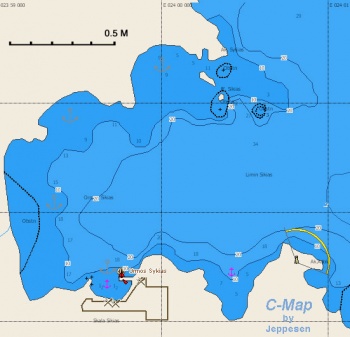
Warning: There are several rocks and reefs on the N side of the cove.
Check-in facilities
None.
Offshore Islands and Groups
None.
Marinas & Yacht Clubs
None.
Anchorages
There are a number of places to anchor around the bay, with varying protection, as shown on the diagram.
The bottom is mostly sand with some weed. Good holding.
With prolonged north-easterly winds a swell comes into the bay. Some protection can be gained by tucking into the deeper coves on the southern side of the bay, including behind the breakwater in the central cove in the south.
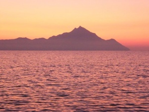
There is a good view of Mt Athos from the main bay.
Yacht Repairs and Services
Marine Stores
None.
Repairs/Yards
None.
Fuel, Water, & Electricity
- Fuel
- N/A (Not Available)
- Water
- N/A
- Electricity
- N/A
Tourism and Things to do Ashore
Tourism
List places of interest, tours, etc.
Grocery & Supply Stores
None in Sikias. In Sarti (![]() 40°5.5041′N, 23°58.7047′E), about 5 miles north, there is at least one supermarket and bakery together.. It is possible to anchor off the Sarti beach and dinghy ashore here. Approach the anchoring point with care to avoid the rock patch about 0.25 miles offshore and just north of this latitude.
40°5.5041′N, 23°58.7047′E), about 5 miles north, there is at least one supermarket and bakery together.. It is possible to anchor off the Sarti beach and dinghy ashore here. Approach the anchoring point with care to avoid the rock patch about 0.25 miles offshore and just north of this latitude.
Eateries
There is a taverna that served good fish.
Internet/WiFi
N/A.
Laundry
N/A.
Motorbike & Car Rentals
N/A.
Garbage Disposal
Trash Can.
Transportation
Transportation (local and/or international)
Routes/Passages To/From
Popular passages/routes, timing, etc.
Cruiser's Friends
Contact details of "Cruiser's Friends" that can be contacted for local information or assistance.
Forum Discussions
List links to discussion threads on partnering forums. (see link for requirements)
External Links
Links to relevant websites.
References & Publications
See Greece.
Last Visited & Details Checked (and updated here)
Date of member's visit to this Port/Stop & this page's details validated:
- Summer 1992 --Istioploos

- July 2011 --Yachtbillabong

Personal Notes
Personal experiences?
|
|---|
|
Names: Istioploos, Yachtbillabong |
| |
|---|
| | HOMEPAGE | Wiki Contents | Mediterranean | Aegean Sea | Greece | Sikias | |

