Hawaii, Big Island
From CruisersWiki
Istioploos (Talk | contribs) (Category) |
m (Bot: Changing template: Guide1) |
||
| Line 168: | Line 168: | ||
| - | {{ | + | {{Page outline}} |
Revision as of 11:43, 11 February 2016
Hawaii (Big Island)
An online cruising guide for yachts sailing to the island of Hawaii.
| | |
| | 19°34′N, 155°30′W |
|---|---|
| | [ADD GALLERY (Panoramio) Photo gallery] |
| | [ADD CHARTLET (MapTech) Local chartlet] |
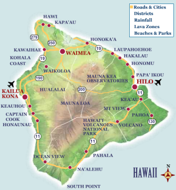
 Map of Hawaii Island - click for larger view Map of Hawaii Island - click for larger view
| |
In greatest dimension, the island is 93 miles (150 km) across and has a land area of 4,028.0 square miles (10,432.5 km²), representing 62% of the total land area of the Hawaiian Islands. Measured from its base at the sea floor, to its highest peak, Mauna Kea is the tallest mountain in the world, even taller than Mount Everest, according to the Guinness Book of Records. Traditionally, Hawaiʻi is known as the Big Island because it is the largest of the Hawaiian Islands and also to ease confusion between Hawaiʻi Island and Hawaiʻi State.
Because Mauna Loa and Kīlauea are active volcanoes, the island of Hawaiʻi is still growing. Between January 1983 and September 2002, 543 acres (220 ha) of land were added to the island by lava flows from Kīlauea volcano extending the coastline seaward. Several towns have been destroyed by Kīlauea lava flows in modern times: Kapoho (1960), Kalapana (1990), and Kaimu (1990). A large fresh water pool, in a deep L-shaped crack in the Kalapana area, well known on the Big Island as Queen's Bath, was flowed over by lava in 1987.
Hawaiʻi is the southernmost island in the Hawaiian archipelago, and contains the southernmost point in the United States, (Ka Lae). The nearest landfall to the south would be in the Line Islands. To the north is the island of Maui, where East Maui Volcano (Haleakalā) is visible across the Alenuihāhā Channel.
Charts
- Source
- Chart Number - Chart Name
- Chart Number - Chart Name
- Source
- Chart Number - Chart Name
Radio Nets
Also see World Cruiser's Nets.
Weather
Give local weather conditions or refer to another page (a region or island group) that covers these conditions.
Sources for Weather forecasts:
Any navigation notes here. If this section does not apply remove it.
Check-in facilities (Customs and Immigration)
If there is no port of entry in the island omit this section, otherwise submit details about facilities for checking in - where to dock, location of immigration & customs, etc.
Berthing Options
Ports
- Hilo (Port of entry)
- Kailua-Kona (Port of entry)
- Kawaihae
Marinas & Yacht Clubs
See each Port.
Anchorages
List anchorages except the ones covered under Offshore Islands below. If there is more then 2 paragraphs for a given anchorage, create a dedicated page for it (Port/Stop Template) We use headings for these so that other pages can link to them. Remove if not applicable..
Offshore Islands
This section does not apply for most islands, if that is the case for this one remove it. You may, however, list ismall islands adjacent to this one or list one or two of its neighbors.
Yacht Services and Repairs
List services. If no services are available on the island write "None" and remove all the subsections (Marine Stores, & Repairs/Yards, & Fuel, Water, & Electricity.
If services are included in specific port pages, the following line is appropriate, otherwise remove it.
Also see each Port.
Marine Stores
Submit addresses and contact details of marine related businesses that are of interest to cruisers.
Repairs/Yards
Fuel, Water, & Electricity
- Fuel
- Give details on fuel
- Water
- Give details on water
- Electricity
- Give details on electricity
Things to do Ashore
Tourism
List places of interest, tours, etc.
Grocery & Supply Stores
Eateries
Internet/WiFi
Available?
Laundry
Motorbike & Car Rentals
Garbage Disposal
?
Transportation
List transportation (local and/or international.)
Routes/Passages To/From
List popular passages/routes, timing, etc.
Cruiser's Friends
Contact details of "Cruiser's Friends" that can be contacted for local information or assistance.
Forum Discussions
List links to discussion threads on partnering forums. (see link for requirements)
External Links
References & Publications
Books, Guides, etc. Use the Reference template or not at your discretion. For example:
-
{{Reference|Rod Heikel|Greek Waters Pilot|Imray|Laurie and Wilson, Cambridgeshire (2010)|9780852889718}}, expands to - Rod Heikell, Greek Waters Pilot, Imray Laurie and Wilson, Cambridgeshire (2010), ISBN 9780852889718
- Author, Title, Publisher, ISBN ISBN number
- Author, Title, Publisher, ISBN ISBN number
You may want to remove the above entries and use instead a link to the Country or Region that lists the relevant references. If so enter, after removing {{MagentaText|xx}}, the following:
See [[Country or Region#References_&_Publications|Coutry or Region]].
If you do not use the above link, please remove it.
Personal Notes
Personal experiences?
Last Visited & Details Checked (and updated here)
Date of member's visit to this Island & this page's details validated:
| This page has an outline in place but needs completing. Please contribute if you can to help it grow further. Click on Comments to suggest further content or alternatively, if you feel confident to edit this page, click on the edit tab at the top and enter your changes directly. |
|
|---|
|
Names: Lighthouse |
| |
|---|
| | HOMEPAGE | Wiki Contents | North & Central Pacific | United States | Hawaii | Hawaii, Big Island | |