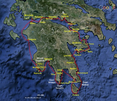
Cruising the Greek Ionian Sea
From CruisersWiki
Revision as of 20:55, 5 February 2010 by Istioploos (Talk | contribs)
Cruising the Greek Ionian Sea
| Peloponnese | |
| MORE notes about the passage |
Introduction
Climate & Weather Information
- See Ionian Sea Weather
- Also see Ionian Sea Currents & Tides
Radio Nets
Also see World Cruiser's Nets.
- Greek Coast Guard - VHF channel 12
- Olympia Radio - This is the Greek VHF network. Local channels are listed in each individual port
- Cellular Phone(GSM/GPRS) - Despite the mountains and the numerous islands Greece and Italy have very good GSM/GPRS coverage.
- BA
- 189 Nisos Sapiénza to Nisos Paxoi
- 206 Corfu: Channels
- 203 Zakinthos to Paxoi
- Imaray-Tetra
- G11 Nísos Kérkira to Nísos Levkas
- NIMA
- 54280 Corfu Channel to Nisis Proti
- Greek
- 2 Ionio Pelagos
- 10 Kerkyra
- 211 Kerkyra I. - Otrando Strait
- 212 Othonoi I. to Amvrakikos Gulf- Kerkyra I. And Paxoi I. Inset: Northern Kerkyra Strait
Passage Description
Distance & Duration
Possible Departure Points
We assume departure from Gouvia Marina ![]() 39°39′N, 19°51.07′E, in the island of Corfu but of course you can depart from any other ports or anchorages listed bellow.
39°39′N, 19°51.07′E, in the island of Corfu but of course you can depart from any other ports or anchorages listed bellow.
Route/Suggested Stopovers
- Start from Gouvia Marina
 39°39′N, 19°51.07′E, in the island of Corfu.
- Sail xx nM to Sivotas Island
 39°39′N, 19°51.07′E in the mainland
- Port Gaios in the island of Paxoi
 39°12.12′N, 20°11.26′E
Possible Arrival Ports
CruiserLog Forum discussions
Links to discussions on the CruiserLog Forum
External Links
See also Ionian Sea.
References
See Ionian Sea.
Personal Notes
| |
|---|
| | HOMEPAGE | Wiki Contents | Mediterranean | Greece | Ionian Sea | Cruising the Greek Ionian Sea | |
.
