Rimini
From CruisersWiki
Rimini, Italy
| | |
| | 44°04.90′N, 12°34.55′E |
|---|---|
| | Photo gallery |
| | Local chartlet |
|
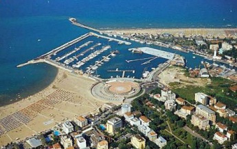
Rimini, situated on the Adriatic coast of Italy 30 miles SSE of Ravenna and 60 miles NW of Ancona, is one of the most famous resorts along this coast, its 15 km long beach and hundreds of smart hotels attracting hordes of tourists from all over Europe during July and August. Founded by the Romans in 268 BC, Rimini’s strategic position at the junction of the Via Flaminia and Via Aemilia, together with its useful harbour at the mouth of the Marecchia river, caused it to expand rapidly. Its importance during the Imperial era is reflected by the numerous monuments and civic works with which it was endowed by emperors such as Augustus, Hadrian and Tiberius. Other rulers who have left their traces on the city are the Byzantines, the 13th to 16th century Malatesta dynasty, the Papal States and even the occupying Napoleonic troops in the late 18th century. The city was badly damaged in both the Great War and World War II, but has risen from the rubble to claim its present position as one of Italy’s busiest tourist resorts. Visiting yachts can usually find a berth either along the canalized river mouth or in the large 600-berth Marina di Rimini.
Charts
British Admiralty 220
Italian charts 923, 37, 215
Radio Nets
Also see World Cruiser's Nets
Local Weather
During the summer months the prevailing winds in the Adriatic are light to moderate coastal seabreezes. In spring and autumn, northerly winds are more frequent and can quickly rise to near gale force, especially in the northern Adriatic, where the much-feared “bora” is caused by high pressure over the mountains to the NE coupled with low pressure over southern Italy. Fortunately, the fiercest “bora” is normally to be expected in the winter months. Thunderstorms are occasionally experienced in spring and especially autumn and can be accompanied by violent winds of gale force and above. Luckily they are rarely long-lasting. In the southern Adriatic, the “scirocco”, a S/SE wind blowing up from North Africa which can last for several days, is more common. Unlike the “bora”, which can arrive without warning, a “scirocco” tends to build in strength over 24-48 hours, sometimes reaching gale force (especially in winter).
Sources for weather information:
- There is a continuous (computerised voice) weather forecast on VHF 68 - first in Italian and then followed with an English translation.
- The same forecast is given in Italian and English on VHF coastal stations following a notification on channel 16.
- Navtex weather forecasts covering the Adriatic are broadcast from stations at Roma, Trieste, Kerkyra (Greece) and Split (Croatia).
Click for larger view
The entrance to the river is marked by a long breakwater extending NNE over 300 metres from the E side of the river and the E/W oriented breakwater of the marina basin some 250 metres inshore. Depths in the entrance are 6.0 metres at the outer end of the breakwater, shoaling to 4.0 metres at the marina entrance and 3.0 - 3.5 metres in the canal basin beyond. If intending to berth in the marina, turn to starboard 150 metres be
