Mar del Plata to Beagle Channel
From CruisersWiki
Mar del Plata to Beagle Channel
Description
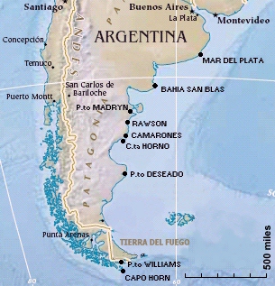
Navigating from Mar del Plata along the coast of Patagonia Argentina first and then to the Tierra del Fuego and Beagle Channel that leads to Puerto Williams (Chile) and Ushuaia (Argentina) can be quite easy or very difficult. The distances between the few ports or bays can be used are initially high and very high in southern Patagonia and Tierra del Fuego, the winds can be very strong: sailing first in the roaring forties and then in fifty screaming. But with careful planning of stops and the weather, having the time to wait for the best conditions is certainly possible to reach "the end of the world" and Cape Horn with sufficient security. Giorgio Ardrizzi author of Patagonia & Tierra del Fuego Nautical Guide, a "Bible" which is absolutely necessary on board, says that it is certainly more dangerous to cross the Atlantic Ocean from Caribbean to Azores which dozens of boats face every year, then the navigation described herein. Having path I both, absolutely confirm his statement. The boat must be absolutely equipped for the high latitudes, here I just mention: HF radio and satellite phone, autopilot robust and reliable, insulation, heating, protected area for the guards, proper rigging, mooring ropes very long, rich set of spare parts etc. etc.
Climate & Weather Information
Argentina weather forecast sources
Chile weather forecast sources
The GRIB files along the Atlantic coast of South America are reliable. To receive them, you must have connection via HF radio Sailmail and connect to the Chilean station, or the connection via satellite phone to Winlink. The Winlink network is not accessible via HF radio as missing ground stations. Rarely receiving stations Winlink South African. It is useful to use the text bulletin of Metarea VI, refer to the catalog of Airmail to request it.
Weather Windows
Reading the pages of Vito Dumas "Towards the Southern Cross-The Roaring Forties" (MURSIA) it turns out that the Yacht Club of South America have advised him to round Cape Horn in winter. The advice to navigate in these turbulent waters during the winter it is located here and there in the literature and what has always intrigued me. There will surely be the true. Leafing through the Pilot Charts you notice that on the coast of Patagonia there is no difference in winds between summer and winter: always from West strength 4, while on the coast of Tierra del Fuego, the average strength of the winter wind is a plus point of the Beaufort scale: 5 in winter and 4 in summer. In winter the average wind direction is from NNW while in summer is from W. Here it becomes obvious that a descent to South winter may make sense, while going to the North would be a difficult navigation. The choice is yours. I went South early in spring (September-October 2014) with conditions similar to those in winter. I returned to North in summer (December 2014-January 2015) and I found myself very well. So you can enjoy the late spring and early summer in the Beagle Channel, and you have the time to go up north without waiting for the following year.
Radio Nets
Also see World Cruiser's Nets.
Argentina: which charts and where to buy
Chile: which charts and where to buy
Below is a selection of charts Argentine and Chilean for the stopover suggested in this text:
- Repubblica Argentina
- H-50 - De Rio de la Plata al paralelo 57 sur - scale 1:3.500.000
- H-251 - Puerto Mar del Plata - scale 1:5.000
- H-213 - De Faro el Rinchon a Faro Secunda Barranca - scale 1:150.000
- H-260 - Bahia San Blas
- H-264 - Puerto Madryn
- H-267 - Rawson
- 3 - Camarones
- 14 - Isla Leones
- 15 - Caleta Horno
- H-360 - Puerto Deseado
- H-361 - Puerto Deseado
- Hinstituto Hydrografico Chile
- 13400 - Isla Nueva a Isla de los Estatos - scale 1:200.000
- 13300 - Canal Beagle e Islas al Sur - scale 1:80.000
- 13100 - Canal Beagle Canal Murray a Puerto Williams - scale 1:80.000
Possible Departure Points
- [[MAR DEL PLATA (ARGENTINA)]] Template:Poi coord
- etc.
Route/Suggested Stopovers
- [[MAR DEL PLATA ARGENTINA]] Template:Poi coord - Departure port and the last with a Marina
- [[BAHIA SAN BLAS]] Template:Poi coord - This is a good stop 270 nm after Mar del Plata
- [[GOLFO NUEVO]] Golfo Nuevo is a wide basin with four anchorages. You must chose them depending of the winds, pay attention that the distance from one to the other are high, 25-30 nm. It is wildlfe santuary with rules to restrict the navigation:
- [[PUERTO MADRYN]] Template:Poi coord - The main town lies on the west side.
- [[Fondeadero Cracker]] Template:Poi coord - Just an anchorage lies in the west side near the Gulf entrance.
- [[PUERTO PYRAMIDES]] Template:Poi coord - A small village in the east side.
- [[Puerto Pardelas]] Template:Poi coord - Just an anchorage in the east side.
- [[RAWSON]] Template:Poi coord - Una ottima alternativa a GOLFO NUEVO, ma la barca deve potersi appoggiare sul fondo perchè il porto rimane senz'acqua a LW
- [[CAMARONES]] Template:Poi coord - Porto peschereccio sede di Prefettura, famoso per i gamberoni e le seppie giganti. Nei pressi due interessanti baie in cui ancorare:
- [[Puerto Santa Elena]] Template:Poi coord - A wide bay with several good anchorages 25 nm nord of CAMARONES. The coordinates are referred to Baliza St Elena, with light, but it was out of order in 2014
- [[Caleta Sara]] Template:Poi coord - 10 nm south of CAMARONES, with a restaurant opened in the week ends
- [[GOLFO SAN JORGE nord side]]
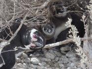
- [[Caleta Leones]] Template:Poi coord - Cala molto riparata a SE dell'Isla Leones, la spiaggia è popolatissima di penguins e sea lions.
- [[Caleta Horno]] Template:Poi coord - Profondo fiordo dalle pareti altissime
- [[PUERTO DESEADO]] The last Argentine port in this route with three place to stop:
- [[COSERENA shipyard]] Template:Poi coord - The best place, si ormeggia al pontone riparati da tutti i venti, essendo un cantiere privato non sempre accetta gli yachts
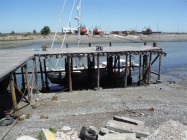
- [[CLUB NAUTICO]] Template:Poi coord - Ancorare con cime a terra al lungo pontile di legno. Stare lontani perchè a LW il termine del pontile va a secco. Protetti da Nord a Est. Nessuna protezione dai venti dominanti da West.
- [[Anchorage SW of Roca Magallanes]] Template:Poi coord - Anchor between the kelps (basso fondo, attenzione) and the shore in 3 metres. Totally open to west winds but with no waves, and no or small tide stream.
- [[PUERTO WILLIAMS (CHILE)]] Template:Poi coord - To moor to Transporte Contramaestre Micalvi
Possible Arrival Ports
- [[PUERTO WILLIAMS (CHILE)]] Template:Poi coord - To moor to Transporte Contramaestre Micalvi
Distance & Duration
| [[MAR DEL PLATA]] | [[BAHIA SAN BLAS]] | [[PUERTO MADRYN]] | [[CAMARONES]] | [[C.ta Horno]] | [[P.to DESEADO]] | [[P.to WILLIAMS]] | |
| [[MAR DEL PLATA]] | 270 1+21 | 490 3+10 | 660 4+14 | 685 4+18 | 855 <5+23/span> | 1455 10+3 | |
| [[BAHIA SAN BLAS]] | 270 1+21 | 220 1+13 | 390 2+17 | 415 2+21 | 585 4+2 | 1185 8+6 | |
| [[PUERTO MADRYN]] | 490 3+10 | 220 1+13 | 170 1+4 | 195 1+9 | 365 2+13 | 965 6+17 | |
| [[CAMARONES]] | 660 4+14 | 390 2+17 | 170 1+4 | 25 0+4 | 195 1+9 | 795 5+13 | |
| [[C.ta Horno]] | 685 4+18 | 415 2+21 | 195 1+9 | 25 0+4 | 170 1+4 | 770 5+8 | |
| [[P.to DESEADO]] | 855 5+23 | 585 4+2 | 365 2+13 | 195 1+9 | 170 1+4 | 600 4+4 | |
| [[P.to WILLIAMS]] | 1455 10+3 | 1185 8+6 | 965 6+17 | 795 5+13 | 770 5+8 | 600 4+4 |
Forum discussions
List links to discussion threads on partnering forums. (see link for requirements)
External Links
List links external to the wiki such as in Wikipedia.
References
- Patagonia & Tierra del Fuego Nautical Guide, 2nd Ed. by Mariolina Rolfo & Giorgio Ardrizzi
- Andrew O'Grady from original material by Ian and Maggy Staples, Chile Arica Desert to Tierra del Fuego, RCC Pilotage Foundation, ISBN ISBN 0852887213
- Author, Title, Publisher, ISBN ISBN number
Personal Notes
Personal experience?
If you provide a lot of info and this page is almost complete, change {{Page outline}} to {{Page useable}}.
| This page has an outline in place but needs completing. Please contribute if you can to help it grow further. Click on Comments to suggest further content or alternatively, if you feel confident to edit this page, click on the edit tab at the top and enter your changes directly. |
| |
|---|
|
Names: Danbag |
Add all the pages that are "parent" to this one.
| Cruising Wiki Navigation
|
|---|
| | HOMEPAGE | Wiki Contents | Place Page Links Here | Place Page Links Here | This Passage | |
