Šćedro
From CruisersWiki
m (→Berthing options) |
Istioploos (Talk | contribs) (Template) |
||
| (24 intermediate revisions not shown) | |||
| Line 1: | Line 1: | ||
| - | + | {{IsPartOf|Mediterranean|Adriatic Sea|Croatia|Central Dalmatia}} | |
| - | + | {{TOC block}} | |
| - | {| | + | {{Infobox |
| - | | | + | | lat=43.092459| lon=16.702995 |
| - | | | + | | name= Šćedro |
| - | | | + | | zoom= 12 |
| - | + | | chartlet = y | |
| - | | {{ | + | | image= |
| - | | | + | | imagetext= {{Magenta|Map or Picture of Island}} |
| - | + | | summary= [[Šćedro]] Island is a small island lying two miles S of the small harbour of [[Zavala]] on the S coast of [[Hvar]] Island in [[Croatia]]. Šćedro used to host a Dominican monastery for over 300 years, but the monks departed in the 18th century and today the only inhabitants are a few holidaymakers and the staff of the restaurants in the bay of the former monastery, [[#U. Manastir|U. Manastir]], and the inlet of [[#Luka Lovište|Luka Lovisce]] half a mile W. | |
| - | + | ||
| - | + | ||
| - | + | ||
| - | + | ||
| - | | | + | |
| - | + | ||
| - | + | ||
| - | + | ||
| - | + | ||
| - | + | There are no harbours on the island, just the two main anchorages on its N side and a few coves on its SE side which are suitable, in settled weather, as anchorages. | |
| - | + | | notes= | |
| - | + | | news= | |
| - | = | + | }} |
| - | + | ||
| - | + | ||
| - | + | ||
| - | + | ||
| - | + | ||
| - | + | ||
| - | + | ||
| - | == | + | ==Charts== |
| - | + | ''See [[Central Dalmatia#Charts|Central Dalmatia]]''. | |
| - | '' | + | |
| - | + | ||
| - | + | ||
| - | + | ==Weather== | |
| + | ''See [[Croatia#Weather|Croatia]]''. | ||
| - | '' | + | ==Passages== |
| + | ''See [[Croatia#Passages|Croatia]]''. | ||
| - | == | + | ==Islands== |
| - | [[Hvar | + | * [[Hvar]] |
| + | * [[Korčula]] | ||
| + | * [[Vis]] | ||
| - | == | + | ==Communication== |
| - | + | {{Green|Add here VHF channel for coastguard, harbor masters. etc.}} | |
| + | * | ||
| + | * | ||
| - | + | ''Also see [[World MM Nets|World Cruiser's Nets]]'' | |
| - | + | ||
| - | + | ==Navigation== | |
| + | {{Green|Add any navigation notes such approaches, dangers etc here. If this section does not apply, remove it.}} | ||
| - | + | ==Berthing== | |
| + | ===Ports=== | ||
| + | None. | ||
| - | + | ===Marinas & Yacht Clubs=== | |
| + | None. | ||
| - | + | ==Anchorages== | |
| + | There are two anchorages on the island: [[#U. Manastir|U. Manastir]] and [[#Luka Lovisce|Luka Lovisce]], both just half a mile apart on the N coast of the island. | ||
| - | + | On the SE coast of Scedro are several coves which look like good potential anchorages or lunch stops in, settled weather. | |
| - | + | ||
| - | + | ||
| - | + | ||
| - | == | + | {{Poi | lat= 43.0952 | lon= 16.70841 | type= anchorage |
| - | + | | name= U. Manastir | |
| + | | zoom= 16 | ||
| + | | image= | ||
| + | | image= ScedroManastir.jpg | ||
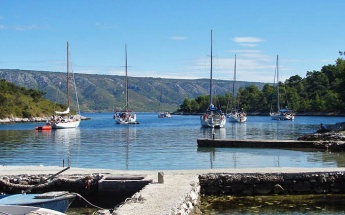
| + | | imagetext= Anchorage of U. Manastir from SW | ||
| + | | text= U. Manastir is a ‘dog leg’ inlet which takes its name from the former Dominican monastery at the head of the bay, the ruins of which can still be seen today. There is a tiny harbour at the head of the inlet, which has depths only suitable for small motor boats. Visiting yachts anchor off in the inlet in depths of 5.0 - 6.0 metres. The holding is good in sand and weed. Alternatively, if eating ashore, a yacht can pick up one of the mooring buoys towards the head of the inlet, which are owned by a restaurant. Depths at the buoys are 3.5 - 4.0 metres. The shelter is good in all conditions except strong N or NW winds. | ||
| + | }} | ||
| + | {{hold vertical}} | ||
| + | {{Poi | lat= 43.09346 | lon= 16.6999 | type= anchorage | ||
| + | | name= Luka Lovište | ||
| + | | zoom= 15 | ||
| + | | image= ScedroLovisce.jpg | ||
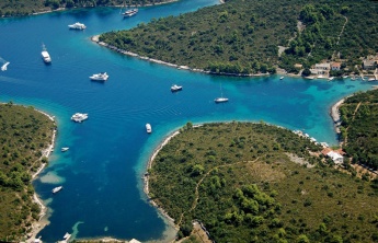
| + | | imagetext= Anchorage of Luka Lovisce from SW | ||
| + | | imagewidth= | ||
| + | | text= Luka Lovište is an attractive anchorage just half a mile W of U. Manastir, with several snug coves in which it is possible to find shelter from all except N winds. Anchor in the cove at the head or in one of the two coves on either side in 8.0 - 9.0 metres. The holding in all three coves is good in sand and weed. There are a few stone bollards if you wish to take lines ashore (which is often necessary during the season as Luka Lovisce is a popular anchorage). There are several restaurants ashore during the summer. }} | ||
| - | == | + | ==Amenities== |
| - | None. | + | None. |
| - | == | + | ==Provisioning== |
| - | None. | + | None. |
| - | == | + | ==Eating out== |
| - | + | * [[#U. Manastir|U. Manastir]] and [[#Luka Lovište|Luka Lovište]] | |
| + | : {{mark |name= | type= eatingout | text=Restaurants, open in the summer.}} | ||
| - | + | ==Transportation== | |
| - | None. | + | None. |
| - | == | + | ==Tourism== |
| - | + | Very little, other than to explore the monastery ruins. | |
| - | == | + | |
| + | ==Friends== | ||
Contact details of "Cruiser's Friends" that can be contacted for local information or assistance. | Contact details of "Cruiser's Friends" that can be contacted for local information or assistance. | ||
| - | * | + | * |
| - | + | ||
| - | + | ||
| - | + | ||
| - | + | ||
| - | + | ||
| - | + | ||
| - | == | + | ==Forums== |
| - | + | List links to discussion threads on [[Cruising Forums|partnering forums]]. (''see link for requirements'') | |
| + | * [http://www.cruisersforum.com/forums/tags/croatia.html Croatia Sailing and Cruising Discussions on Cruisers Forum] | ||
| + | * | ||
| - | == | + | ==Links== |
| - | + | * {{wikipedia}} | |
| - | * | + | * |
| - | == | + | |
| - | '' | + | For other useful websites, ''see [[Croatia#Links|Croatia]]''. |
| - | *July 2005 --[[User:Atheneoflymington|Athene of Lymington]] 16:20, 15 November 2012 (GMT) | + | |
| - | + | ==References== | |
| - | {{ | + | ''See [[Croatia#References|Croatia]]''. |
| - | + | ||
| - | + | {{Comments}} | |
| - | + | * | |
| - | + | * | |
| - | + | ||
| - | + | {{Verified by}} | |
| - | + | * July 2005 --[[User:Atheneoflymington|Athene of Lymington]] 16:20, 15 November 2012 (GMT) | |
| - | + | * | |
| + | |||
| + | |||
| + | {{Page useable}} | ||
| - | |||
| - | |||
| - | |||
| - | |||
| - | |||
| - | |||
| + | {{Contributors|[[User:Lighthouse|Lighthouse]], [[User:Atheneoflymington|Athene of Lymington]]}} | ||
[[Category:Islands - Croatia]] [[Category:Anchorages - Croatia]] | [[Category:Islands - Croatia]] [[Category:Anchorages - Croatia]] | ||
Latest revision as of 22:04, 21 April 2019
| Šćedro
| |
| |
Šćedro Island is a small island lying two miles S of the small harbour of Zavala on the S coast of Hvar Island in Croatia. Šćedro used to host a Dominican monastery for over 300 years, but the monks departed in the 18th century and today the only inhabitants are a few holidaymakers and the staff of the restaurants in the bay of the former monastery, U. Manastir, and the inlet of Luka Lovisce half a mile W.
There are no harbours on the island, just the two main anchorages on its N side and a few coves on its SE side which are suitable, in settled weather, as anchorages.
Charts
See Central Dalmatia.
Weather
See Croatia.
Passages
See Croatia.
Islands
Communication
Add here VHF channel for coastguard, harbor masters. etc.
Also see World Cruiser's Nets
Add any navigation notes such approaches, dangers etc here. If this section does not apply, remove it.
Berthing
Ports
None.
Marinas & Yacht Clubs
None.
Anchorages
There are two anchorages on the island: U. Manastir and Luka Lovisce, both just half a mile apart on the N coast of the island.
On the SE coast of Scedro are several coves which look like good potential anchorages or lunch stops in, settled weather.
U. Manastir
Luka Lovište
Amenities
None.
Provisioning
None.
Eating out
-
 [[Šćedro# | ]] Restaurants, open in the summer.
Transportation
None.
Tourism
Very little, other than to explore the monastery ruins.
Friends
Contact details of "Cruiser's Friends" that can be contacted for local information or assistance.
Forums
List links to discussion threads on partnering forums. (see link for requirements)
Links
- Šćedro at the Wikipedia
For other useful websites, see Croatia.
References
See Croatia.
Comments
We welcome users' contributions to the Wiki. Please click on Comments to view other users' comments, add your own personal experiences or recommend any changes to this page following your visit.
Verified by
Date of member's last visit to Šćedro and this page's details validated:
- July 2005 --Athene of Lymington 16:20, 15 November 2012 (GMT)
| This is a usable page of the cruising guide. However, please contribute if you can to help it grow further. Click on Comments to add your personal notes on this page or to discuss its contents. Alternatively, if you feel confident to edit the page, click on the edit tab at the top and enter your changes directly. |
| |
|---|
|
Names: Lighthouse, Athene of Lymington |

