Agathonisi
From CruisersWiki
(→Last Visited & Details Checked (and updated here)) |
m (Text replace - "==References & Publications==" to "==References==") |
||
| (48 intermediate revisions not shown) | |||
| Line 1: | Line 1: | ||
| - | + | {{IsPartOf|Mediterranean|Aegean Sea|Greece|Dodecanese}} | |
| - | {| | + | {{TOC block}} |
| - | | | + | |
| - | | | + | |
| - | + | ||
| - | + | ||
| - | + | ||
| - | + | ||
| - | + | ||
| - | + | ||
| - | + | ||
| - | + | ||
| - | + | ||
| - | + | ||
| + | {{infobox | lat=37.46191| lon=26.96817 | ||
| + | | chartlet=y | ||
| + | | zoom= 13 | ||
| + | | image= Greece_Agathonisi_S.jpg | ||
| + | | imagetext= Satellite view of Agathonisi | ||
| + | | notes= | ||
| + | | news= | ||
| + | }} | ||
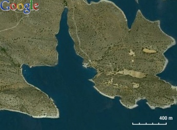
[http://en.wikipedia.org/wiki/Agathonisi Agathonisi] (Αγαθονήσι - Good island) or Gaidaros (Donkey), or Gaidouronisi (Donkey island), is a favorite of many cruisers. It is a small island with about 150 inhabitants living in two villages: 125 in the Megalo Chorio (Μεγάλο Χωριό - Big Village), and 25 in the Mikro Chorio (Μικρό Χωριό - Small Village), its tallest point is 189 m above sea level. Its area, combined with neighboring islets, is 14.5 km<sup>2</sup>. | [http://en.wikipedia.org/wiki/Agathonisi Agathonisi] (Αγαθονήσι - Good island) or Gaidaros (Donkey), or Gaidouronisi (Donkey island), is a favorite of many cruisers. It is a small island with about 150 inhabitants living in two villages: 125 in the Megalo Chorio (Μεγάλο Χωριό - Big Village), and 25 in the Mikro Chorio (Μικρό Χωριό - Small Village), its tallest point is 189 m above sea level. Its area, combined with neighboring islets, is 14.5 km<sup>2</sup>. | ||
| Line 19: | Line 15: | ||
==Charts== | ==Charts== | ||
| - | |||
| - | |||
; BA | ; BA | ||
: 2682 Kólpos Petalion to Nísos Nísiros | : 2682 Kólpos Petalion to Nísos Nísiros | ||
| Line 32: | Line 26: | ||
: 422 Naxos to Samos & Opposite Coast of Asia Minor | : 422 Naxos to Samos & Opposite Coast of Asia Minor | ||
| - | == | + | ==Weather== |
| - | '' | + | ''See [[Aegean_Sea#Weather|Aegean Sea]]''. |
| + | ==Passages== | ||
| + | * [[Cruising the Samos Sea Islands]] | ||
| + | * [[Cruising the Dodecanese Islands]] | ||
| + | |||
| + | ==Islands== | ||
| + | None. | ||
| + | |||
| + | ==Communication== | ||
* Coast Guard - VHF Channel 12 | * Coast Guard - VHF Channel 12 | ||
* Olympia Radio - VHF No signal | * Olympia Radio - VHF No signal | ||
| - | + | ''Also see [[HF_Radio|Cruiser's Nets]]''. | |
| - | '' | + | |
| - | == | + | ==Navigation== |
Approaches to Agathonisi are straightforward except: | Approaches to Agathonisi are straightforward except: | ||
| - | |||
| - | + | {{Warning}} There is a reef to the E of the islet on NE of the island. It is right on the course coming from [[Samos]]. There are also some rocky ledges on the west coast which are only just above water. Stay at least half a mile off. | |
| - | + | ||
| - | == | + | ==Berthing== |
There are many coves in Agathonisi but only one harbor, Port Ayios Yioryios or San Giorgio. | There are many coves in Agathonisi but only one harbor, Port Ayios Yioryios or San Giorgio. | ||
===Ports=== | ===Ports=== | ||
| - | + | {{Poi |37|27.2|N|26|57.95|E| | type= harbour |name= Port Ayios Yioryios |altname= San Giorgio |zoom= 16 | |
| - | + | | image = Greece_Agathonisi_StGeorgioS.jpg | imagetext= St. Georgio Region | imagewidth= | |
| - | + | | text= The small harbor, Port Ayios Yioryios or San Giorgio, is at the south of the island at the end of a large bay whose western entrance has a light house (''Qk Fl W 4M''). It is very well protected from the ''meltemi'', but exposed to southerly winds. The main ferry quay on the east side, where most yachts moor, has depths of 5.5 metres all along. However, the northern third is reserved for coastguard use and the southern third is used by the ferry. Yachts can berth alongside, avoiding the nasty black rubber fenders, but only on the middle third. It is possible to berth alongside the southern third, but you should be prepared to move off for 10 minutes or so when a ferry is due. (Note: it is preferable to go alongside rather than doing an anchor moor, as the depths are considerable – 12 -15 metres – and the holding suspect in weed). There is a further, low quay at the end of the inlet, which has depths of only 1.5 metres and is really only suitable for small craft. | |
| - | The small harbor, Port Ayios Yioryios or San Giorgio, is at the south of the island at the end of a large bay whose western entrance has a light house (''Qk Fl W 4M''). It is very well protected from the ''meltemi'', but exposed to southerly winds. The main ferry quay on the east side, where most yachts moor, has depths of 5.5 metres all along. However, the northern third is reserved for coastguard use and the southern third is used by the ferry. Yachts can berth alongside, avoiding the nasty black rubber fenders, but only on the middle third. It is possible to berth alongside the southern third, but you should be prepared to move off for 10 minutes or so when a ferry is due. (Note: it is preferable to go alongside rather than doing an anchor moor, as the depths are considerable – 12 -15 metres – and the holding suspect in weed). There is a further, low quay at the end of the inlet, which has depths of only 1.5 metres and is really only suitable for small craft. | + | |
Alternatively one can anchor just off the beach at the head of the inlet. Drop your anchor in 5-6 metres towards the east side of the sandy patch and let out no more than 25 metres of chain to avoid swinging into the buoyed-off swimming area. Because of the tightness of the swinging space here, it is usually only possible for one yacht to anchor close in; later arrivals will need to anchor further out, ensuring their anchors penetrate the thick weed. However, there are two yellow-painted metal bollards set into the rocks just east of the beach, and two or three yachts could anchor here with care, taking stern lines back to the bollards to prevent swinging. | Alternatively one can anchor just off the beach at the head of the inlet. Drop your anchor in 5-6 metres towards the east side of the sandy patch and let out no more than 25 metres of chain to avoid swinging into the buoyed-off swimming area. Because of the tightness of the swinging space here, it is usually only possible for one yacht to anchor close in; later arrivals will need to anchor further out, ensuring their anchors penetrate the thick weed. However, there are two yellow-painted metal bollards set into the rocks just east of the beach, and two or three yachts could anchor here with care, taking stern lines back to the bollards to prevent swinging. | ||
| Line 61: | Line 59: | ||
Ashore, there are three tavernas of which ''Glaros'' (owner Yiannis, 2000) is popular with long term cruisers. Another of the tavernas has a very small very basic grocery store. | Ashore, there are three tavernas of which ''Glaros'' (owner Yiannis, 2000) is popular with long term cruisers. Another of the tavernas has a very small very basic grocery store. | ||
| - | A new fuel station has opened in 2000 right across the quay but you still need to use jerry cans as | + | A new fuel station has opened in 2000 right across the quay but you still need to use jerry cans as they do not have a long hose. |
| - | From Port San Giorgio one can walk to either Megalo Chorio (about 30 minutes) or Mikro Chorio (20 minutes). At Megalo Chorio there is a Post office and | + | From Port San Giorgio one can walk to either Megalo Chorio (about 30 minutes) or Mikro Chorio (20 minutes). At Megalo Chorio there is a Post office and two basic grocery stores. }} |
| - | + | {{hgallery| | |
| - | + | {{himage|AgathonisiAnchorage.jpg|Anchorage at Ayios Yioryios}} | |
| - | + | {{himage|AgathonisiFerry.jpg|Ayios Yioryios quay at ferry time}} | |
| - | + | }} | |
| - | + | ===Marinas & Yacht Clubs=== | |
| - | + | None. | |
| - | + | ||
| - | + | ||
| - | + | ||
| - | + | ||
| - | + | ||
| - | + | ==Anchorages== | |
| - | + | {{Poi |37|27|N|26|58.2|E| | type= anchorage |name= Tsangaris |zoom= 16 | |
| - | { | + | | image = Agathonisi_Tsangaris_h.jpg | imagetext= Sketch of Tsangaris | imagewidth= |
| - | + | | text= In the same bay as Port San Giorgio and to its east, there is the Tsangaris (Τσαγκάρης - cobbler) cove, it is reasonably protected from the ''meltemi'', although there is a westerly breeze in many summer afternoons. It is a tranquil anchorage from which one can easily visit [[#Port_San_Giorgio|San Giorgio]] with the dinghy. | |
| - | In the same bay as Port San Giorgio and to its east, there is the Tsangaris (Τσαγκάρης - cobbler) cove, it is reasonably protected from the ''meltemi'', although there is a westerly breeze in many summer afternoons. It is a tranquil anchorage from which one can easily visit [[#Port_San_Giorgio|San Giorgio]] with the dinghy. | + | |
It is best to drop the anchor as close to the SE shore (reasonable holding) and take 2 stern lines to the NW shore which shelters the boat from the afternoon breeze. | It is best to drop the anchor as close to the SE shore (reasonable holding) and take 2 stern lines to the NW shore which shelters the boat from the afternoon breeze. | ||
| - | A short walk up the hill there is a nice double chapel of Saint John the Baptist and Saint Irene (about 15 minutes). Also, there is a path going north that eventually connects to the dirt road leading to Megalo Chorio (about an hour). | + | A short walk up the hill there is a nice double chapel of Saint John the Baptist and Saint Irene (about 15 minutes). Also, there is a path going north that eventually connects to the dirt road leading to Megalo Chorio (about an hour). }} |
| - | + | {{Image center|Greece_Agathonisi_Tsagaris.jpg|Tsangaris |400px}} | |
| - | + | ||
| - | + | ||
| - | + | ||
| - | | | + | {{Poi |37|27.3|N|26|57.8|E| | type= anchorage |name= Spelia |zoom= 17 |
| - | | | + | | image = Agathonisi_Spelia_h.jpg | imagetext= Sketch of Spelia | imagewidth= |
| - | + | | text= Another good cove is west of Port San Giorgio, also known by the locals as Spelia (Σπηλιά - Cave). It is reasonably protected from the ''meltemi''. It is less isolated than [[#Tsangaris|Tsangaris]] because a dirt road, leading to [[#Port_San_Giorgio|San Giorgio]], was bulldozed in 1995. | |
| - | + | ||
| - | + | ||
| - | + | ||
| - | + | ||
| - | + | ||
| - | + | ||
| - | + | ||
| - | + | ||
| - | Another good cove is west of Port San Giorgio, also known by the locals as Spelia (Σπηλιά - Cave). It is reasonably protected from the ''meltemi''. It is less isolated than [[#Tsangaris|Tsangaris]] because a dirt road, leading to [[#Port_San_Giorgio|San Giorgio]], was bulldozed in 1995. | + | |
It is best to drop the anchor as close to the SW shore on a patch of sand and take a line ashore to a rock at the NE shore (under the road). | It is best to drop the anchor as close to the SW shore on a patch of sand and take a line ashore to a rock at the NE shore (under the road). | ||
| Line 110: | Line 90: | ||
There may be a few campers at the small beach. [[#Port_San_Giorgio|San Giorgio]] is about a 10 minute walk. | There may be a few campers at the small beach. [[#Port_San_Giorgio|San Giorgio]] is about a 10 minute walk. | ||
| - | + | {{Warning}}Check the holding of your anchor because there are patches of loose weed. }} | |
| - | + | {{hold vertical}} | |
| - | + | ||
| - | + | ||
| - | + | ||
| - | | | + | {{image center|AgathonisiCave.jpg |Spelia anchorage from ashore | 350px}} |
| - | |} | + | |
| - | + | {{Image right| Greece_Agathonisi_Gaidouravlako_S.jpg| Satellite View of Gaidouravlako}} | |
| + | {{Poi |37|27.1|N|26|57.7|E| | type= anchorage |name= Gaidourávlako |zoom= 16 | ||
| + | | text= The cove of Gaidourávlako (Γαϊδουραύλακκο - oxen trough) is just S of [[#Spelia|Spelia]]. It is more isolated and wider. It is reasonably protected from the ''meltemi''. | ||
| - | + | Anchor in the middle of the cove at 4-5 m. Holding is better than at [[#Spelia|Spelia]] but it is further away from [[#Port_San_Giorgio|San Giorgio]] (long dinghy ride). It is useful to take a line from the bow to a rock on the S side of the cove, this prevents swinging and eases the strain on the anchor.}} | |
| - | + | ||
| - | + | ||
| - | + | ||
| - | + | {{Image center|Greece_Agathonisi_Gaidouravlako.jpg |Gaidouravlako from the Shore |400px }} | |
| - | + | {{Image right| Greece_Agathonisi_Catholiko_S.jpg| Satellite View of Catholic}} | |
| - | + | {{Poi |37|28.3|N|26|59.3|E| | type= anchorage |name= Catholiko |zoom= 15 | |
| - | + | | text= On the north side of the island there is the small anchorage, Catholiko (Καθολικό - Catholic) which provides year round shelter (protected from both the norther ''meltemi'' and the southerlies) . | |
| - | + | ||
| - | + | ||
| - | | | + | |
| - | + | ||
| - | + | ||
| - | + | ||
| - | + | ||
| - | + | ||
| - | + | ||
| - | + | ||
| - | + | ||
| - | + | ||
| - | + | ||
| - | On the north side of the island there is the small anchorage, Catholiko (Καθολικό - Catholic) which provides year round shelter (protected from both the norther ''meltemi'' and the southerlies) . | + | |
Anchor offshore. Good holding. | Anchor offshore. Good holding. | ||
| - | There a few houses and small fishing harbor. No facilities. The concrete road leads to Megalo Chorio (1 hour on foot). A fish farm spoils some of the charm of this anchorage. | + | There a few houses and small fishing harbor. No facilities. The concrete road leads to Megalo Chorio (1 hour on foot). A fish farm spoils some of the charm of this anchorage.}} |
| - | + | {{hold vertical}} | |
| - | + | ||
| - | + | ||
| - | + | ||
| - | | | + | {{image center|Agathonisi_2.jpg |Catholiko Bay | 345px}} |
| - | |} | + | |
| - | + | {{Image right| Greece_Agathonisi_EastBay.jpg| Satellite View of East Bay}} | |
| + | {{Poi |37|27.3|N|26|59.5|E| | type= anchorage |name= East Bay |zoom= 15 | ||
| + | | text= About 1.2 nM east of the [[#Port_San_Giorgio|Port San Giorgio]] bay there is another large bay with several coves. These are not as well protected as the coves in the San Giorgio bay and are only good for a brief stop. | ||
| - | + | The water is somewhat polluted by the large fish farm at the head of the bay. }} | |
| - | + | ||
| - | + | ||
| - | + | ||
| - | + | ==Amenities== | |
| + | {{tlist | ||
| - | + | |header|Facilities | |
| - | + | ||
| - | + | ||
| - | + | ||
| - | | | + | |Water| N/A (Not Available) |
| - | | | + | |Electricity| N/A |
| + | |Toilets| N/A | ||
| + | |Showers| N/A | ||
| + | |Laundry| N/A | ||
| + | |Garbage| There are bins in the port | ||
| - | + | |header|Supplies | |
| - | None | + | |Fuel| [[#San Giorgio|San Giorgio]]: available by mini tanker on the quay |
| + | |Bottled gas| N/A | ||
| + | |Chandlers| None | ||
| - | + | |header|Services | |
| - | + | |Repairs| N/A | |
| - | + | |Internet| N/A | |
| + | |Mobile connectivity| Good 3G and at times 4G signal | ||
| + | |Vehicle rentals| N/A | ||
| + | }} | ||
| - | ==== | + | ==Provisioning== |
| - | + | {{mark |name= [[#San Giorgio|San Giorgio]] | type= provisions |text= One of the tavernas has a very small and very basic grocery store.}} | |
| - | === | + | {{mark |name= Megalo Chorio | type= provisions | |text= Tthere are two basic grocery stores.}} |
| - | + | ||
| - | + | ||
| - | + | ||
| - | + | ||
| - | + | ||
| - | + | ||
| - | == | + | ==Eating out== |
| - | + | [[#San Giorgio|San Giorgio]] | |
| + | : {{mark |name= ''Glaros'' (now transformed to the ''Seagull''| type= eatingout |text= The owner Yiannis is very friendly to yachties.}} | ||
| - | |||
| - | |||
| - | |||
| - | |||
| - | |||
| - | |||
| - | |||
| - | |||
| - | There | + | ==Transportation== |
| + | * There is a hydrofoil from [[Samos]] going to [[Patmos]] that calls at [[#Port_San_Giorgio|Port San Giorgio]] several times a week | ||
| + | * Ferryboat from [[Kos]] | ||
| - | == | + | ==Tourism== |
| - | + | {{Image right| Greece_Agathonisi_AyPanteleimon.jpg| Ayios Panteleimon in Mikro Chorio|250px}} | |
| - | + | {{Image right| Agathonisi_Chapel.jpg| The Chapel of Saint John the Baptist<br />and Saint Irene over Tsangaris|250px }} | |
| - | + | There are many walks in this relatively unspoiled island. Over [[#Tsangaris|Tsangaris]] there is a nice chapel and the walk from Megalo Chorio to Catholiko is fun. | |
| - | + | galo Chorio there are two basic grocery stores | |
| - | + | ||
| - | == | + | ==Friends== |
| - | + | ||
| - | + | ||
| - | + | ||
| - | + | ||
| - | + | ||
| - | + | ||
| - | + | ||
| - | + | ||
| - | + | ||
| - | + | ||
| - | + | ||
| - | + | ||
| - | + | ||
| - | + | ||
| - | + | ||
| - | + | ||
| - | + | ||
| - | + | ||
| - | + | ||
| - | + | ||
| - | + | ||
| - | + | ||
| - | + | ||
| - | + | ||
| - | + | ||
Contact details of "Cruiser's Friends" that can be contacted for local information or assistance. | Contact details of "Cruiser's Friends" that can be contacted for local information or assistance. | ||
| - | == | + | ==Forums== |
| - | List links to discussion threads on [[Cruising Forums|partnering forums]]. (see link for requirements) | + | List links to discussion threads on [[Cruising Forums|partnering forums]]. (''see link for requirements'') |
| - | + | ||
* | * | ||
* | * | ||
| - | == | + | ==Links== |
| - | * | + | * {{wikipedia}} |
| - | * | + | * {{Wikivoyage}} |
* | * | ||
| - | ==References | + | ==References== |
| - | See [[Greece#References_&_Publications|Greece]]. | + | ''See [[Greece#References_&_Publications|Greece]]''. |
| - | + | {{Comments}} | |
| - | + | * | |
| - | + | {{Verified by}} | |
| - | + | * June 1996 ([[#East Bay|East Bay]]) {{Istioploos2}} | |
| + | * July 1997 ([[#Catholiko|Catholiko]]) --[[User:Istioploos|Istioploos]] | ||
| + | * September 2003 ([[#Tsangaris|Tsangaris]]) --[[User:Istioploos|Istioploos]] | ||
| + | * July 2006 ([[#Spelia|Spelia]]) --[[User:Istioploos|Istioploos]] [[Image:Greece_Icon.png]] | ||
| + | * September 2010 ([[#Port Ayios Yioryios|Port Ayios Yioryios]], [[#Spelia|Spelia]]) --[[User:Atheneoflymington|Athene of Lymington]] 11:11, 21 September 2010 (UTC) | ||
| + | * October 2016 ([[#Port Ayios Yioryios|Port Ayios Yioryios]], [[#Gaidourávlako|Gaidourávlako]]) --[[User:Istioploos|Istioploos]] | ||
* | * | ||
| + | {{Page useable}} | ||
| - | |||
| + | {{Contributors|[[User:Lighthouse|Lighthouse]], [[User:Istioploos|Istioploos]], [[User:Atheneoflymington|Athene of Lymington]]}} | ||
| - | + | [[Category:Islands - Greece]] | |
| - | + | ||
| - | + | ||
| - | + | ||
| - | + | ||
| - | + | ||
| - | + | ||
Latest revision as of 11:38, 15 August 2018
| Agathonisi
| |
| | |
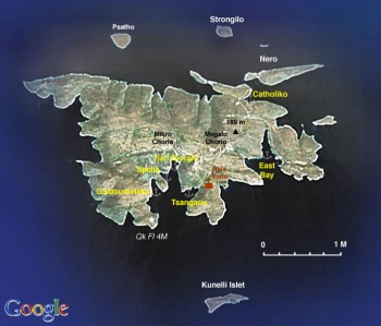
Agathonisi (Αγαθονήσι - Good island) or Gaidaros (Donkey), or Gaidouronisi (Donkey island), is a favorite of many cruisers. It is a small island with about 150 inhabitants living in two villages: 125 in the Megalo Chorio (Μεγάλο Χωριό - Big Village), and 25 in the Mikro Chorio (Μικρό Χωριό - Small Village), its tallest point is 189 m above sea level. Its area, combined with neighboring islets, is 14.5 km2.
While Agathonisi belongs to the Dodecanese prefecture, most of its goods come from nearby Samos (only 15 nM to the N). It is an island out of the main tourist stream and it has many protected coves as well as a small but well sheltered harbour and ferry port, Ayios Yioryios.
Charts
- BA
- 2682 Kólpos Petalion to Nísos Nísiros
- 1546 Samos Strait to Güllük Körfezi
- Imray-Tetra
- G32 Eastern Sporades
- NIMA
- 54400 Nisos Samos to Nisos Rhodhos
- 54403 Samos Strait to Nisos Kalolimnos
- Greek
- 422 Naxos to Samos & Opposite Coast of Asia Minor
Weather
See Aegean Sea.
Passages
Islands
None.
Communication
- Coast Guard - VHF Channel 12
- Olympia Radio - VHF No signal
Also see Cruiser's Nets.
Approaches to Agathonisi are straightforward except:
Warning: There is a reef to the E of the islet on NE of the island. It is right on the course coming from Samos. There are also some rocky ledges on the west coast which are only just above water. Stay at least half a mile off.
Berthing
There are many coves in Agathonisi but only one harbor, Port Ayios Yioryios or San Giorgio.
Ports
Port Ayios Yioryios
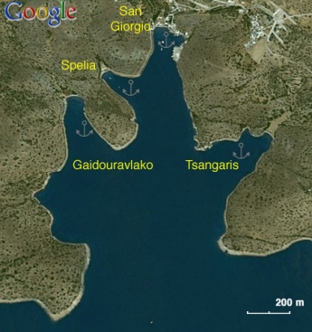
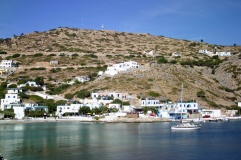
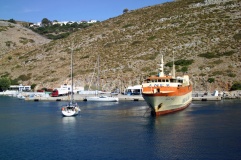
The small harbor, Port Ayios Yioryios or San Giorgio, is at the south of the island at the end of a large bay whose western entrance has a light house (Qk Fl W 4M). It is very well protected from the meltemi, but exposed to southerly winds. The main ferry quay on the east side, where most yachts moor, has depths of 5.5 metres all along. However, the northern third is reserved for coastguard use and the southern third is used by the ferry. Yachts can berth alongside, avoiding the nasty black rubber fenders, but only on the middle third. It is possible to berth alongside the southern third, but you should be prepared to move off for 10 minutes or so when a ferry is due. (Note: it is preferable to go alongside rather than doing an anchor moor, as the depths are considerable – 12 -15 metres – and the holding suspect in weed). There is a further, low quay at the end of the inlet, which has depths of only 1.5 metres and is really only suitable for small craft.
Alternatively one can anchor just off the beach at the head of the inlet. Drop your anchor in 5-6 metres towards the east side of the sandy patch and let out no more than 25 metres of chain to avoid swinging into the buoyed-off swimming area. Because of the tightness of the swinging space here, it is usually only possible for one yacht to anchor close in; later arrivals will need to anchor further out, ensuring their anchors penetrate the thick weed. However, there are two yellow-painted metal bollards set into the rocks just east of the beach, and two or three yachts could anchor here with care, taking stern lines back to the bollards to prevent swinging.
Ashore, there are three tavernas of which Glaros (owner Yiannis, 2000) is popular with long term cruisers. Another of the tavernas has a very small very basic grocery store.
A new fuel station has opened in 2000 right across the quay but you still need to use jerry cans as they do not have a long hose.
From Port San Giorgio one can walk to either Megalo Chorio (about 30 minutes) or Mikro Chorio (20 minutes). At Megalo Chorio there is a Post office and two basic grocery stores.Marinas & Yacht Clubs
None.
Anchorages
Tsangaris
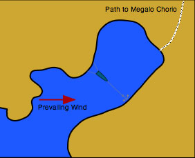
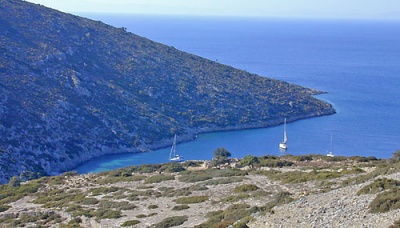
In the same bay as Port San Giorgio and to its east, there is the Tsangaris (Τσαγκάρης - cobbler) cove, it is reasonably protected from the meltemi, although there is a westerly breeze in many summer afternoons. It is a tranquil anchorage from which one can easily visit San Giorgio with the dinghy.
It is best to drop the anchor as close to the SE shore (reasonable holding) and take 2 stern lines to the NW shore which shelters the boat from the afternoon breeze.
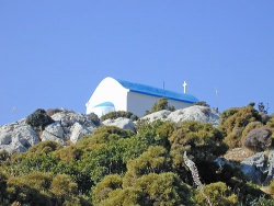
A short walk up the hill there is a nice double chapel of Saint John the Baptist and Saint Irene (about 15 minutes). Also, there is a path going north that eventually connects to the dirt road leading to Megalo Chorio (about an hour).Spelia
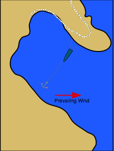
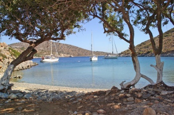
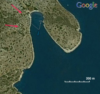
Another good cove is west of Port San Giorgio, also known by the locals as Spelia (Σπηλιά - Cave). It is reasonably protected from the meltemi. It is less isolated than Tsangaris because a dirt road, leading to San Giorgio, was bulldozed in 1995.
It is best to drop the anchor as close to the SW shore on a patch of sand and take a line ashore to a rock at the NE shore (under the road).
There may be a few campers at the small beach. San Giorgio is about a 10 minute walk.
Warning: Check the holding of your anchor because there are patches of loose weed.Gaidourávlako
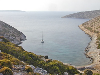
The cove of Gaidourávlako (Γαϊδουραύλακκο - oxen trough) is just S of Spelia. It is more isolated and wider. It is reasonably protected from the meltemi.
Anchor in the middle of the cove at 4-5 m. Holding is better than at Spelia but it is further away from San Giorgio (long dinghy ride). It is useful to take a line from the bow to a rock on the S side of the cove, this prevents swinging and eases the strain on the anchor.Catholiko
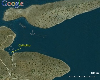
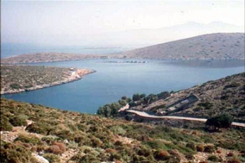
On the north side of the island there is the small anchorage, Catholiko (Καθολικό - Catholic) which provides year round shelter (protected from both the norther meltemi and the southerlies) .
Anchor offshore. Good holding.
There a few houses and small fishing harbor. No facilities. The concrete road leads to Megalo Chorio (1 hour on foot). A fish farm spoils some of the charm of this anchorage.East Bay
About 1.2 nM east of the Port San Giorgio bay there is another large bay with several coves. These are not as well protected as the coves in the San Giorgio bay and are only good for a brief stop.
The water is somewhat polluted by the large fish farm at the head of the bay.Amenities
| Facilities | |
|---|---|
| Water | N/A (Not Available) |
| Electricity | N/A |
| Toilets | N/A |
| Showers | N/A |
| Laundry | N/A |
| Garbage | There are bins in the port |
| Supplies | |
| Fuel | San Giorgio: available by mini tanker on the quay |
| Bottled gas | N/A |
| Chandlers | None |
| Services | |
| Repairs | N/A |
| Internet | N/A |
| Mobile connectivity | Good 3G and at times 4G signal |
| Vehicle rentals | N/A |
Provisioning
![]() San Giorgio [[Agathonisi#San Giorgio|San Giorgio]] One of the tavernas has a very small and very basic grocery store.
San Giorgio [[Agathonisi#San Giorgio|San Giorgio]] One of the tavernas has a very small and very basic grocery store.
![]() Megalo Chorio [[Agathonisi#Megalo Chorio|Megalo Chorio]] Tthere are two basic grocery stores.
Megalo Chorio [[Agathonisi#Megalo Chorio|Megalo Chorio]] Tthere are two basic grocery stores.
Eating out
-
 Glaros (now transformed to the Seagull [[Agathonisi#Glaros (now transformed to the Seagull|Glaros (now transformed to the Seagull]] The owner Yiannis is very friendly to yachties.
Transportation
- There is a hydrofoil from Samos going to Patmos that calls at Port San Giorgio several times a week
- Ferryboat from Kos
Tourism
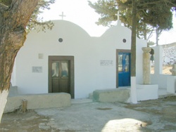
There are many walks in this relatively unspoiled island. Over Tsangaris there is a nice chapel and the walk from Megalo Chorio to Catholiko is fun. galo Chorio there are two basic grocery stores
Friends
Contact details of "Cruiser's Friends" that can be contacted for local information or assistance.
Forums
List links to discussion threads on partnering forums. (see link for requirements)
Links
- Agathonisi at the Wikipedia
- Agathonisi at the Wikivoyage
References
See Greece.
Comments
We welcome users' contributions to the Wiki. Please click on Comments to view other users' comments, add your own personal experiences or recommend any changes to this page following your visit.
Verified by
Date of member's last visit to Agathonisi and this page's details validated:
- June 1996 (East Bay) --Istioploos

 Travels with S/Y Thetis
- July 1997 (Catholiko) --Istioploos
- September 2003 (Tsangaris) --Istioploos
- July 2006 (Spelia) --Istioploos

- September 2010 (Port Ayios Yioryios, Spelia) --Athene of Lymington 11:11, 21 September 2010 (UTC)
- October 2016 (Port Ayios Yioryios, Gaidourávlako) --Istioploos
| This is a usable page of the cruising guide. However, please contribute if you can to help it grow further. Click on Comments to add your personal notes on this page or to discuss its contents. Alternatively, if you feel confident to edit the page, click on the edit tab at the top and enter your changes directly. |
| |
|---|
|
Names: Lighthouse, Istioploos, Athene of Lymington |
