Andros-Greece
From CruisersWiki
Lady Marie D (Talk | contribs) (→Batsi) |
m (Text replace - "==References & Publications==" to "==References==") |
||
| (25 intermediate revisions not shown) | |||
| Line 1: | Line 1: | ||
| - | + | {{IsPartOf|Mediterranean|Aegean Sea|Greece|Cyclades}} | |
| - | + | {{TOC block}} | |
| - | + | {{Infobox | lat=37.85| lon=24.86667 | |
| - | + | | zoom= 10 | |
| - | + | | chartlet=y | |
| - | + | | image= Greece_Andros_S.jpg | |
| - | + | | imagetext= Satellite view of Andros | |
| - | + | }} | |
| - | + | ||
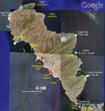
| - | + | [http://en.wikipedia.org/wiki/Andros Andros] (Άνδρος), a member of the [http://en.wikipedia.org/wiki/Cyclades Cyclades]. It is 380,041 km<sup>2</sup> and has about 10,009 inhabitants. The highest peak of Andros is 944 m (3097 ft). Andros is not a very touristic island but it is the home of several very rich shipowner families like the fabulously wealthy [http://www.crwflags.com/FOTW/flags/gr~hfgou.html#pre Goulandris]; as a result it is very well kept without the usual tourist related hassles. | |
| - | + | ||
| - | + | ==Charts== | |
| - | + | ; BA | |
| - | + | : 2682 Kólpos Patalion to Nísos Nísiros | |
| - | + | : 1038 Stenó Sífnou to Stenó Kafiréa | |
| - | + | ; Imray-Tetra | |
| - | + | : G3 Aegean Sea (South) | |
| - | + | : G31 Northern Cyclades | |
| - | + | ; NIMA | |
| - | + | : 54355 Nisos Andros & Dhiekplous Kafireos | |
| - | + | ; Greek | |
| - | + | : 42 Andros to Chalki Island | |
| - | + | : 421 Karystos to Naxos | |
| - | + | ||
| - | + | ==Weather== | |
| - | + | ''See [[Aegean_Sea#Weather|Aegean Sea]]''. | |
| - | + | ||
| - | + | ==Passages== | |
| - | + | * [[Passages between Athens Region and Samos - Kusadasi]] | |
| - | + | * [[Cruising the Cyclades Islands]] | |
| - | + | ||
| - | + | ==Islands== | |
| - | + | {{Poi |37|35.5|N|24|42.7|E| | type= island| name= Yiaros | |
| - | + | | text= Yiaros is a barren uninhabited island mid-way between [[Kea]] and [[Tinos]] and about 8 nM south-west of Andros. There are no anchorages but with sheltered weather one can anchor in an exposed little cove on its south side of the island for lunch or a swim. There are strong gusts here with the ''meltemi''. | |
| - | + | ||
| - | Gavrio (Γαύριο) provides the best shelter in the island. You can either anchor off-shore or go stern-to at the quay. The bottom is mud and provides good holding. | + | The island was used as a place of exile for political prisoners as recently as during the[http://en.wikipedia.org/wiki/Greek_junta Junta of the Colonels] (1967-72). }} |
| - | + | ||
| - | + | ==Communication== | |
| - | + | * Coast Guard - VHF channel 12 Tel. +30 2820 22 572 | |
| - | + | * Olympia Radio - VHF channel 04 | |
| - | + | ||
| - | + | ''Also see [[World MM Nets|World Cruiser's Nets]]''. | |
| - | + | ||
| - | + | ==Navigation== | |
| - | + | In general the west side of the island experiences strong gusts when the ''meltemi'' blows. For particulars see individual ports or anchorages. | |
| - | + | ||
| - | + | ==Berthing== | |
| - | + | There are several anchorages in Andros. The main harbor on the more protected west side of the island, Gavrio is very busy with ferry boats. Most cruisers prefer the quieter, nearby Batsi. | |
| - | Batsi | + | |
| - | + | ===Ports=== | |
| - | + | {{Poi |37|53|N|24|44|E|| type= harbour |name= Gavrio |altname= Γαύριο) |zoom= 15 | |
| - | + | | image= Greece_Andros_Gavrion_h.jpg | |
| - | + | | imagetext= Chart of Gavrio | |
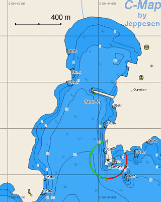
| - | + | | text= Gavrio (Γαύριο) provides the best shelter in the island. You can either anchor off-shore or go stern-to at the quay. The bottom is mud and provides good holding. | |
| - | + | ||
| - | + | {{Caution}}There are several reefs in the approach to Gavrio. In particular there is Vouvi with dangerous shoals at the sourh-east entrance, the rock Rosa, and shoal waters near the islets Akamatis and Plati. }} | |
| - | + | ||
| - | + | {{hold vertical}} | |
| - | + | ||
| - | + | {{Poi |37|51.39|N|24|46.98|E| | type= harbour |name= Batsi |altname= Μπατσί) |zoom= 16 | |
| - | + | | image= Greece_Andros_Batsi_h.jpg | |
| - | + | | imagetext= Chart of Batsi | |
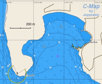
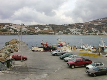
| - | + | | text= Batsi is just 2 3/4 nM south-east of [[#Gavrio|Gavrio]] and provides good shelter, although it can be gusty, from the ''meltemi'' but it is exposed to the south. You can either anchor off-shore or go stern-to at the small quay. There is room for 10+ boats stern to facing north east and another 7 side to the east and west of the new extension to the mole. Depths alongside the new mole are >5 metres. The bottom is sand and provides good holding. There are no harbour fees to pay although there is a self-styled harbour master who will guide you to a space and attempt to collect one. We checked with the port police; their understanding with him is that he can do this work for tips, but certainly not charge a nightly fee or direct boats to move. An "official" port police/harbour master's office is built and slated to open in 2016. Electricity and potable water free of charge from posts on the quay. | |
| - | + | ||
| - | | | + | This is a pleasant and quiet anchorage (if you are off-shore) and yet there are enough stores and restaurants ashore. There is fuel available from a station but it is uphill and out of town, not an easy walk carrying jerry cans. You can rent cars and motorbikes. }} |
| - | + | ||
| - | + | {{hgallery| | |
| - | + | {{himage|Greece_Andros_Batsi.jpg|The Harbor of Batsi}} | |
| - | + | {{himage|Greece_Andros_Batsi1.jpg|Anchored off}} | |
| - | + | }} | |
| - | + | ||
| - | + | {{Poi |37|50.6|N|24|56.4|E| | type= harbour |name= Kastro |altname= Κάστρο |zoom= 15 | |
| - | + | | text= Castro is the capital of Andros also known as Andros or Chora or Hora. | |
| - | + | ||
| - | + | The small yacht harbor in Chora has been enlarged and there is now room for many more yachts. As of May 2014 water and electricity had not been installed. --[[User:Daphnoula|Daphnoula]] | |
| - | + | ||
| - | + | {{Danger}}The is not protected from the ''meltemi'' and it can be dangerous. There is a dangerous reef directly at the approach into the harbor. | |
| - | + | ||
| - | Korthi | + | I have moored here during the 1980's and again in the 90's during a strong meltemi and the area behind the large mole was quite comfortable. --[[User:Daphnoula|Daphnoula]] }} |
| - | + | ||
| - | + | ===Marinas & Yacht Clubs=== | |
| - | + | None. | |
| - | + | ||
| - | + | ==Anchorages== | |
| - | + | {{Poi |37|46.5|N|24|57.9|E| | type= anchorage |name= Korthi |altname= Κορθί |zoom= 15 | |
| - | + | | image= Greece_Andros3.jpg | |
| - | + | | imagetext= Korthi | |
| - | + | | text= Korthi is a very lovely cove. | |
| - | + | ||
| - | + | {{Warning}}It is exposed to the east and it is not protected from the ''meltemi'' and it can be dangerous when it blows.}} | |
| - | + | ||
| - | + | {{Poi |37|49|N|24|49|E| | type= anchorage| name= Palaioupolis Bay | |
| - | + | | text= This is a lovely anchorage about 3 nMi south-east of [[#Batsi|Batsi]]. There is reasonable protection from the ''meltemi'' but it is very exposed to the south. | |
| - | + | ||
| - | + | Anchor off-shore. The bottom is sand. | |
| - | + | ||
| - | + | There are some underwater foundations of the ancient harbor and some ruins ashore. | |
| - | + | ||
| - | + | Katabatic winds with a ''meltemi'' can be fierce here. --[[User:Daphnoula|Daphnoula]]}} | |
| - | + | ||
| - | + | {{Poi |37|45.8|N|24|53.1|E| | type= anchorage| name= Plaka Bay | |
| - | + | | text= This is a small bay south of Cape Zagora. }} | |
| - | + | ||
| - | + | ==Amenities== | |
| - | + | {{tlist | |
| - | + | ||
| - | + | |header|Facilities | |
| - | + | ||
| - | + | |Water| {{MagentaText|?}} | |
| - | + | |Electricity| N/A (Not Available) | |
| - | + | |Toilets| {{MagentaText|?}} | |
| - | + | |Showers| {{MagentaText|?}} | |
| - | + | |Laundry| {{MagentaText|?}} | |
| - | + | |Garbage| There are bins around the harbors and in several anchorages | |
| - | + | ||
| - | + | |header|Supplies | |
| - | + | |Fuel| There is fuel available in [[#Batsi|Batsi]] from a station but it is uphill and out of town, not an easy walk carrying jerry cans | |
| - | + | |Bottled gas| {{MagentaText|?}} | |
| - | + | |Chandlers| None | |
| - | + | ||
| - | + | |header|Services | |
| - | + | |Repairs| {{MagentaText|?}} | |
| - | + | |Internet| In internet cafés | |
| - | + | |Mobile connectivity| Good 3G signa | |
| - | + | |Vehicle rentals| Available in both [[#Gavrio|Gavrio]] and [[#Batsi|Batsi]] | |
| - | + | }} | |
| - | + | ||
| - | + | ==Provisioning== | |
| - | + | Good food shopping in both [[#Gavrio|Gavrio]] and [[#Batsi|Batsi]] | |
| - | + | ||
| - | + | ==Eating out== | |
| - | + | * [[#Batsi|Batsi]] | |
| - | + | : {{mark |name= Adonis | type= eatingout |text= serves some very good ''mezedes'' (tasty morsels).}} | |
| - | + | : Several restaurants | |
| - | + | * [[#Gavrio|Gavrio]] | |
| - | + | : Several restaurants | |
| - | + | ||
| - | + | ==Transportation== | |
| - | + | There are daily, and in the summer several per day ferries to Rafina. | |
| - | + | ||
| - | + | ==Tourism== | |
| - | + | ====History==== | |
| - | + | The island was named after the Cretan general Andros, the grandson of [http://www.maicar.com/GML/Apollo.html Apollo]. It has been inhabited since pre-historic times by Karians, [http://en.wikipedia.org/wiki/Phoenicia Phoenicians], [http://en.wikipedia.org/wiki/Ancient_Egypt Egyptians], [http://en.wikipedia.org/wiki/Minoan_Civilisation Cretans], [http://en.wikipedia.org/wiki/Pelasgians Pelasgians], and [http://en.wikipedia.org/wiki/Ionia Ionian Greeks]. During the 7th century BC Andros was very prosperous. In [http://en.wikipedia.org/wiki/Classical_antiquity Classical times] Andros was a reluctant member of the [http://en.wikipedia.org/wiki/Delian_League Delian Leaque] headed by Athens. During the 13th century AD it was taken from the [http://en.wikipedia.org/wiki/Byzantine_Empire Byzantines] by the Frankish [http://en.wikipedia.org/wiki/Fourth_Crusade crusaders] and then by the [http://en.wikipedia.org/wiki/Ottoman_Empire Ottomans] in 1556 to be followed by the Russians in 1774. After the [http://en.wikipedia.org/wiki/Greek_War_of_Independence 1821 war of independence] Andros became part of Modern Greece. | |
| - | + | ||
| - | + | ====Places to Visit==== | |
| - | + | =====Chora===== | |
| - | + | [[Image:Greece_Andros2.jpg|frame|right|Street of Museum of Modern Art]] | |
| - | + | ||
| - | + | Chora (Χώρα) is the capital of Andros also known as Andros or Hora. It is a very picturesque town with traditional Cycladic architecture. | |
| - | + | ||
| - | + | In town, of interest are the [http://odysseus.culture.gr/h/1/eh151.jsp?obj_id=3282 Archaeological Museum] which houses many finds from Palaiopolis and Zagora. There is also a small but very good [http://odysseus.culture.gr/h/1/eh151.jsp?obj_id=3283&theme_id=25 Museum of Modern Art] which houses a collection of the local sculptor M. Tombros as well as works of the most important contemporary Greek artists. They also have regular exhibits of non-Greek modern artists. The museum is housed in a very pleasant building which harmonizes with the Cycladic architecture. | |
| - | + | ||
| - | + | In modern times Andros has been the home island of many wealthy shipowners, in particular the various members of the [http://www.crwflags.com/FOTW/flags/gr~hfgou.html#pre Goulandris] family. The [http://odysseus.culture.gr/h/1/eh151.jsp?obj_id=3284&theme_id=1362 Maritime Museum of Andros] shows some of this tradition. | |
| - | + | ||
| - | + | =====Palaiopolis===== | |
| - | + | In addition to the excavation site and the underwater jetty there is a local exhibit of the [http://www.gtp.gr/TDirectoryDetails.asp?ID=13093 Archaeological Collection of Palaiopolis]. | |
| - | + | ||
| - | + | =====Zagora===== | |
| - | + | Here is the site of the [http://www.travel-to-andros.com/place.php?place_id=10 Geometric settlement at Zagora]. | |
| - | + | ||
| - | + | =====Gavrion===== | |
| - | + | A prominent feature of Gavrion is the [http://www.travel-to-andros.com/place.php?place_id=11 Tower at Aghios Petros]. It is dated from the Hellenistic period (4th-3rd centuries BC) and it is worth a visit. | |
| - | + | ||
| - | + | ==Friends== | |
| - | + | Contact details of "Cruiser's Friends" that can be contacted for local information or assistance. | |
| - | + | ||
| - | + | ==Forums== | |
| - | + | List links to discussion threads on [[Cruising Forums|partnering forums]]. (''see link for requirements'') | |
| - | + | * | |
| - | + | * | |
| - | + | * | |
| - | + | ||
| - | + | ==Links== | |
| - | + | * {{Wikipedia|Andros|Andros}} | |
| - | + | * {{Wikivoyage|Andros|Andros}} | |
| - | + | * | |
| - | + | ||
| - | + | ==References== | |
| - | + | ''See [[Greece#References_&_Publications|Greece]]''. | |
| - | + | ||
| - | + | {{Comments}} | |
| - | + | * | |
| + | |||
| + | {{Verified by}} | ||
| + | * 1986 ([[#Gavrio|Gavrio]]) {{Istioploos2}} | ||
| + | * September 2000 ([[#Batsi|Batsi]]) --[[User:Istioploos|Istioploos]] | ||
| + | * 2014 ([[#Batsi|Batsi]]) [[User:Daphnoula|Daphnoula]] | ||
| + | * June 2015 ([[#Batsi|Batsi]]) --[[User:Monterey|Monterey]] [[Image:Bermuda Icon.png]] | ||
| + | * July 2015 ([[#Batsi|Batsi]]) --[[User:Lady Marie D|Lady Marie D]] | ||
| + | * | ||
| + | |||
| + | |||
| + | {{Page useable}} | ||
| + | |||
| + | |||
| + | {{Contributors|[[User:Lighthouse|Lighthouse]], [[User:Istioploos|Istioploos]]}} | ||
| + | |||
| + | [[Category:Islands - Greece]] | ||
Latest revision as of 11:39, 15 August 2018
| Andros-Greece
| |
| | |
Andros (Άνδρος), a member of the Cyclades. It is 380,041 km2 and has about 10,009 inhabitants. The highest peak of Andros is 944 m (3097 ft). Andros is not a very touristic island but it is the home of several very rich shipowner families like the fabulously wealthy Goulandris; as a result it is very well kept without the usual tourist related hassles.
Charts
- BA
- 2682 Kólpos Patalion to Nísos Nísiros
- 1038 Stenó Sífnou to Stenó Kafiréa
- Imray-Tetra
- G3 Aegean Sea (South)
- G31 Northern Cyclades
- NIMA
- 54355 Nisos Andros & Dhiekplous Kafireos
- Greek
- 42 Andros to Chalki Island
- 421 Karystos to Naxos
Weather
See Aegean Sea.
Passages
Islands
Yiaros
Yiaros is a barren uninhabited island mid-way between Kea and Tinos and about 8 nM south-west of Andros. There are no anchorages but with sheltered weather one can anchor in an exposed little cove on its south side of the island for lunch or a swim. There are strong gusts here with the meltemi.
The island was used as a place of exile for political prisoners as recently as during theJunta of the Colonels (1967-72).Communication
- Coast Guard - VHF channel 12 Tel. +30 2820 22 572
- Olympia Radio - VHF channel 04
Also see World Cruiser's Nets.
In general the west side of the island experiences strong gusts when the meltemi blows. For particulars see individual ports or anchorages.
Berthing
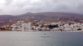
There are several anchorages in Andros. The main harbor on the more protected west side of the island, Gavrio is very busy with ferry boats. Most cruisers prefer the quieter, nearby Batsi.
Ports
Gavrio
Gavrio (Γαύριο) provides the best shelter in the island. You can either anchor off-shore or go stern-to at the quay. The bottom is mud and provides good holding.
Caution: There are several reefs in the approach to Gavrio. In particular there is Vouvi with dangerous shoals at the sourh-east entrance, the rock Rosa, and shoal waters near the islets Akamatis and Plati.Batsi
Batsi is just 2 3/4 nM south-east of Gavrio and provides good shelter, although it can be gusty, from the meltemi but it is exposed to the south. You can either anchor off-shore or go stern-to at the small quay. There is room for 10+ boats stern to facing north east and another 7 side to the east and west of the new extension to the mole. Depths alongside the new mole are >5 metres. The bottom is sand and provides good holding. There are no harbour fees to pay although there is a self-styled harbour master who will guide you to a space and attempt to collect one. We checked with the port police; their understanding with him is that he can do this work for tips, but certainly not charge a nightly fee or direct boats to move. An "official" port police/harbour master's office is built and slated to open in 2016. Electricity and potable water free of charge from posts on the quay.
This is a pleasant and quiet anchorage (if you are off-shore) and yet there are enough stores and restaurants ashore. There is fuel available from a station but it is uphill and out of town, not an easy walk carrying jerry cans. You can rent cars and motorbikes.Kastro
Castro is the capital of Andros also known as Andros or Chora or Hora.
The small yacht harbor in Chora has been enlarged and there is now room for many more yachts. As of May 2014 water and electricity had not been installed. --Daphnoula
Danger: The is not protected from the meltemi and it can be dangerous. There is a dangerous reef directly at the approach into the harbor.
I have moored here during the 1980's and again in the 90's during a strong meltemi and the area behind the large mole was quite comfortable. --DaphnoulaMarinas & Yacht Clubs
None.
Anchorages
Korthi
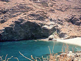
Korthi is a very lovely cove.
Warning: It is exposed to the east and it is not protected from the meltemi and it can be dangerous when it blows.Palaioupolis Bay
This is a lovely anchorage about 3 nMi south-east of Batsi. There is reasonable protection from the meltemi but it is very exposed to the south.
Anchor off-shore. The bottom is sand.
There are some underwater foundations of the ancient harbor and some ruins ashore.
Katabatic winds with a meltemi can be fierce here. --DaphnoulaPlaka Bay
Amenities
| Facilities | |
|---|---|
| Water | ? |
| Electricity | N/A (Not Available) |
| Toilets | ? |
| Showers | ? |
| Laundry | ? |
| Garbage | There are bins around the harbors and in several anchorages |
| Supplies | |
| Fuel | There is fuel available in Batsi from a station but it is uphill and out of town, not an easy walk carrying jerry cans |
| Bottled gas | ? |
| Chandlers | None |
| Services | |
| Repairs | ? |
| Internet | In internet cafés |
| Mobile connectivity | Good 3G signa |
| Vehicle rentals | Available in both Gavrio and Batsi |
Provisioning
Good food shopping in both Gavrio and Batsi
Eating out
-
 Adonis [[Andros-Greece#Adonis|Adonis]] serves some very good mezedes (tasty morsels).
- Several restaurants
- Several restaurants
Transportation
There are daily, and in the summer several per day ferries to Rafina.
Tourism
History
The island was named after the Cretan general Andros, the grandson of Apollo. It has been inhabited since pre-historic times by Karians, Phoenicians, Egyptians, Cretans, Pelasgians, and Ionian Greeks. During the 7th century BC Andros was very prosperous. In Classical times Andros was a reluctant member of the Delian Leaque headed by Athens. During the 13th century AD it was taken from the Byzantines by the Frankish crusaders and then by the Ottomans in 1556 to be followed by the Russians in 1774. After the 1821 war of independence Andros became part of Modern Greece.
Places to Visit
Chora
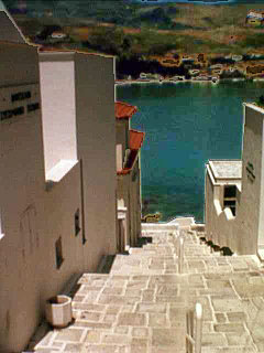
Chora (Χώρα) is the capital of Andros also known as Andros or Hora. It is a very picturesque town with traditional Cycladic architecture.
In town, of interest are the Archaeological Museum which houses many finds from Palaiopolis and Zagora. There is also a small but very good Museum of Modern Art which houses a collection of the local sculptor M. Tombros as well as works of the most important contemporary Greek artists. They also have regular exhibits of non-Greek modern artists. The museum is housed in a very pleasant building which harmonizes with the Cycladic architecture.
In modern times Andros has been the home island of many wealthy shipowners, in particular the various members of the Goulandris family. The Maritime Museum of Andros shows some of this tradition.
Palaiopolis
In addition to the excavation site and the underwater jetty there is a local exhibit of the Archaeological Collection of Palaiopolis.
Zagora
Here is the site of the Geometric settlement at Zagora.
Gavrion
A prominent feature of Gavrion is the Tower at Aghios Petros. It is dated from the Hellenistic period (4th-3rd centuries BC) and it is worth a visit.
Friends
Contact details of "Cruiser's Friends" that can be contacted for local information or assistance.
Forums
List links to discussion threads on partnering forums. (see link for requirements)
Links
References
See Greece.
Comments
We welcome users' contributions to the Wiki. Please click on Comments to view other users' comments, add your own personal experiences or recommend any changes to this page following your visit.
Verified by
Date of member's last visit to Andros-Greece and this page's details validated:
- 1986 (Gavrio) --Istioploos

 Travels with S/Y Thetis
- September 2000 (Batsi) --Istioploos
- 2014 (Batsi) Daphnoula
- June 2015 (Batsi) --Monterey

- July 2015 (Batsi) --Lady Marie D
| This is a usable page of the cruising guide. However, please contribute if you can to help it grow further. Click on Comments to add your personal notes on this page or to discuss its contents. Alternatively, if you feel confident to edit the page, click on the edit tab at the top and enter your changes directly. |
| |
|---|
|
Names: Lighthouse, Istioploos |
