Balearic Islands
From CruisersWiki
(Difference between revisions)
Istioploos (Talk | contribs) (Headings) |
Istioploos (Talk | contribs) (Interactive Map) |
||
| Line 1: | Line 1: | ||
==The Balearics Cruising Guide== | ==The Balearics Cruising Guide== | ||
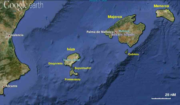
| - | [[Image:Spain_Balearics s.jpg| | + | An online cruising guide for yachts sailing around the Balearic Sea of [[Spain]]. |
| + | |||
| + | <imagemap> | ||
| + | Image:Spain_Balearics s.jpg|750px|center|<center>Sattelite view of the Balearics - <em>For details click on a name or an area</em></center> | ||
| + | rect 765 12 875 114 [[Menorca|Menorca or Minorca]] | ||
| + | rect 427 64 733 239 [[Majorca|Majorca or Mallorca]] | ||
| + | rect 620 246 700 285 [[Cabrera]] | ||
| + | poly 357 336 425 286 378 236 332 232 319 312 322 329 [[Ibiza]] | ||
| + | rect 238 306 315 331 [[Dragonera]] | ||
| + | rect 370 330 462 353 [[Espalmador]] | ||
| + | poly 357 337 393 367 410 406 319 406 319 388 [[Formentera]] | ||
| + | rect 37 152 134 198 [[Valencia]] | ||
| + | rect 1 407 104 459 [[Alicante]] | ||
| + | </imagemap> | ||
| + | |||
| + | |||
{{TOCleft}} | {{TOCleft}} | ||
{| class="infobox bordered" style="width: 28em; text-align: left; font-size: 90%;" | {| class="infobox bordered" style="width: 28em; text-align: left; font-size: 90%;" | ||
| Line 80: | Line 95: | ||
====Last Visited & Details Checked (and updated here)==== | ====Last Visited & Details Checked (and updated here)==== | ||
''Date of member's visit to this Port/Stop & this page's details validated'': | ''Date of member's visit to this Port/Stop & this page's details validated'': | ||
| - | * October 2004 --[[User:Istioploos|Istioploos]] [[Image:Greece_Icon.png]] | + | * October 2004 --[[User:Istioploos|Istioploos]] [[Image:Greece_Icon.png]] [[File:Sailboat_favicon.png]] [http://www.sy-thetis.org Travels with S/Y Thetis] |
* | * | ||
Revision as of 20:50, 28 February 2015
The Balearics Cruising Guide
An online cruising guide for yachts sailing around the Balearic Sea of Spain.

| | |
| | 39°33′N, 02°39′E |
|---|---|
| | Photo gallery |
| | Local chartlet |
Charts
- BA
- 1780 Barcelona to Napoli including Islas Baleares and Sardegna
- 1703 Mallorca and Menorca
- 1702 Ibiza, Formentera and southern Mallorca
- 1700 Cartagena to Cabo de San Antonio including Isla Formentera
- NIMA
- 52140 Islas Baleares
- 52143 Mahon and Approaches
- 52142 Ibiza and Approaches
Weather and Winds
See Spain.
Regional Radio Nets
Also see World Cruiser's Nets.
Islands in the Group
![]() = Featured Cruising Guides,
= Featured Cruising Guides, ![]() = Port of Entry,
= Port of Entry, ![]() = Marina,
= Marina, ![]() = Harbor,
= Harbor, ![]() = Anchorage,
= Anchorage, ![]() = Needs data.
= Needs data.
Things to do Ashore
See individual islands.
Routes/Passages To/From
See Aegean to West Mediterranean Passages.
Cruiser's Friends
Contact details of "Cruiser's Friends" that can be contacted for local information or assistance.
Forum Discussions
List links to discussion threads on partnering forums. (see link for requirements)
External Links
References & Publications
- Graham Hutt and RCC Pilotage Foundation, Islas Baleares: Ibiza, Formentera, Mallorca, Cabrera and Menorca, Imray Laurie Norie & Wilson; 9th Revised edition edition (March 30, 2011), ISBN 9781846232831
- Rod Heikell, Mediterranean Cruising Handbook, Imray Laurie Norie & Wilson; 6th Revised edition edition (April 21, 2012), ISBN 9781846231704
- Rod Heikell and Lucinda Michel, Mediterranean Almanac, Imray Laurie Norie & Wilson; 8th edition edition (December 12, 2012), ISBN 9781846232961
Personal Notes
Personal experiences?
Last Visited & Details Checked (and updated here)
Date of member's visit to this Port/Stop & this page's details validated:
- October 2004 --Istioploos

 Travels with S/Y Thetis
|
|---|
|
Names: Lighthouse, Alan Teed, Istioploos |
| |
|---|
| | HOMEPAGE | Wiki Contents | Mediterranean | Spain | MedSpain | Balearics | |