Cape Verde
From CruisersWiki
An online cruising guide for yachts sailing to The Cape Verde Islands.
| Cape Verde
| |
| Capital | Praia |
|---|---|
| Language | Portuguese, Cape Verdean Creole |
| Currency | Cape Verdean Escudo (CVE) |
| Time zone | CVT (UTC-1) |
| Calling code | +238 |
| | |
| (Dec '09): Caution: There has been a serious outbreak of Dengue Fever on the Cape Verde Islands. | |
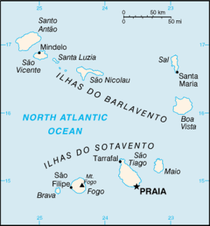
Cape Verde is an independent country of 4,033 km2 and 418,224 inhabitants. It consists of an island archipelago of 10 islands. The capital, Praia, is in the island of Santiago.
The islands, which were uninhabited, were colonized by the Portuguese in the 15th century. They used the islands, and especially the port of Mindelo, as trade center for the then flourishing slave trade from W. Africa. Most inhabitants of Cape Verde are mestiços, descendants of the white Portuguese settlers and black African slaves. Mestiços’ European ancestors also include Spanish and Italian seamen who were granted land by Portuguese Empire and followed by Portuguese settlers and exiles and Portuguese Jews who were victims of Inquisition. Today's inhabitants speak in a language with recognizable French and Portuguese words called Crioulo. They are handsome people and although poor they are very dignified. There are a number of Cape Verdean seamen who serve on Greek merchant ships and you often come across people who speak Greek. Also manu have relatives who have immigrated to the US.
The islands became independent from Portugal in 1975 but still have many economic ties with Portugal. Today they are e republic with an elected president who serves for 5 year terms under a General Assembly of elected representatives.
Mindelo is the major harbor of the island São Vicente of Cape Verde.
Charts
- BA
- 366 Arquipélago de Cabo Verde
- NIMA
- 51500 Cape Verde (Northern Part)
- 51540 Cape Verde (Southern Part)
Weather
Cape Verde is in the tropical zone. Average temperatures range from 24 °C (75 °F) in January and February to 29 °C (85 °F) in September. The average annual rainfall for Cape Verde is 68.4 mm (2.7 in), with September being the wettest month with 33.6 mm (1.3 in). Conversely, the months April to July record less than one millimetre of rainfall each. The climate is arid, but Cape Verde's position in the Atlantic contributes to soften the aridity.
Sources for weather forecast information:
- Weather on Line Detail 7 day forecast charts for the Atlantic.
- Wind GURU A surfer's site with worldwide wind forecasts.
- Navtex Broadcasts List of all the Navtex broadcast times and frequencies (not kept up to date).
Passages
Communication
Also see World Cruiser's Nets.
Approaching from the NE is straight forward until near the Mindelo channel when the wind accelerates and is very gusty.
Entrance
Cape Verde manages to have a good bureaucracy. Clearing into Cape Verde (in |Mindelo), while not hard, can be time consuming. You need to clear with the harbor, customs, and immigration (Policia de Fronteira), all in different locations and with erratic hours. The port authorities, Policia Maritima (Tel. +238 324 4144), will make you sign a form that absolves them from any responsibility in the case of theft. They also will keep your yacht papers which they will return after paying the fee (500 CVE) during clearing out. Clearing out takes longer then clearing in.
Immigration, Visas & Customs
Immigration
Details?
Customs
Details?
Health & Security
Health
Submit any health warnings/information. Remove any of these sections do not apply to this particular country.
Security
It is advisable to lock the boat and the dinghy.
Islands, Ports, Marinas, and Anchorages
|
|
|
Transportation
List transportation to other countries, etc.
Cruiser's Friend
Submit details/contacts of cruiser's "friends" that can be contacted in advance or on arrival - who can offer information and assistance to our cruising "family".
Forums
List links to discussion threads on partnering forums. (see link for requirements)
Links
- Cape Verde at the Wikipedia
- Cape Verde at the Wikivoyage
- Cape Verde - CIA World Factbook
References
- Anne Hammick: RCC Pilotage Foundation, Atlantic Islands Cruising Guide: Azores, Madeira Group, Canary Islands and Cape Verdes, Imray Laurie Norie & Wilson; 5th ed edition (December 11, 2011), ISBN 978-1846233364
- Anne Hammick and Gavin McLaren: RCC Pilotage Foundation, Atlantic Crossing Guide, Adlard Coles; Sixth Edition edition (October 1, 2010), ISBN 9781408113806
- Jimmy Cornell, World Cruising Handbook: Covering All the Maritime Nations of the World, Adlard Coles Nautical; 3rd edition (July 31, 2001), ISBN 978-0713658279
Comments
We welcome users' contributions to the Wiki. Please click on Comments to view other users' comments, add your own personal experiences or recommend any changes to this page following your visit.
Verified by
Date of member's last visit to Cape Verde and this page's details validated:
- January 2005 --Istioploos

| This is a usable page of the cruising guide. However, please contribute if you can to help it grow further. Click on Comments to add your personal notes on this page or to discuss its contents. Alternatively, if you feel confident to edit the page, click on the edit tab at the top and enter your changes directly. |
| |
|---|
|
Names: Lighthouse, Istioploos |

