Cefalu
From CruisersWiki
m (→Cefalu, Sicily, Italy) |
Lighthouse (Talk | contribs) (Changed TOC) |
||
| Line 1: | Line 1: | ||
== Cefalu, Sicily, Italy == | == Cefalu, Sicily, Italy == | ||
| - | {| class="infobox bordered" style="width: | + | {| class="infobox bordered" style="width: 29em; text-align: left; font-size: 85%;" |
|- | |- | ||
| colspan="2" style="text-align:center; font-size: smaller;" | {{Small info}} (''Click links for more information'') | | colspan="2" style="text-align:center; font-size: smaller;" | {{Small info}} (''Click links for more information'') | ||
| Line 13: | Line 13: | ||
| [ Local chartlet] | | [ Local chartlet] | ||
|} | |} | ||
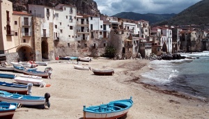
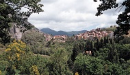
| - | [[Image:CefaluTown.jpg|300px|thumb| | + | [[Image:CefaluTown.jpg|300px|thumb|right|'''Old town, Cefalu'''<br/>''Click for larger view'']] |
| - | The town and marina of Cefalu are situated roughly in the centre of the N coast of Sicily, around 35 miles E of Palermo. Originally a defensive settlement on the huge rock that looms over the town (Cefalu = ''Greek'' headland), the town was re-established at the foot of the bluff by the 12th century Normans, who also constructed the tiny harbour west of the town and the magnificent cathedral that towers over it. Today, cruising yachtsmen visiting the town are better served by the pontoons in the Porto Nuovo, a purpose-built harbour constructed on the more sheltered eastern side of the headland. The town itself is one of the most atmospheric in the whole of the island, its picturesque fishermen's houses huddled around the old harbour, and is justifiably one of Sicily’s most popular tourist destinations. | + | The town and marina of Cefalu are situated roughly in the centre of the N coast of [[Sicily]], around 35 miles E of [[Palermo]]. Originally a defensive settlement on the huge rock that looms over the town (Cefalu = ''Greek'' headland), the town was re-established at the foot of the bluff by the 12th century Normans, who also constructed the tiny harbour west of the town and the magnificent cathedral that towers over it. Today, cruising yachtsmen visiting the town are better served by the pontoons in the Porto Nuovo, a purpose-built harbour constructed on the more sheltered eastern side of the headland. The town itself is one of the most atmospheric in the whole of the island, its picturesque fishermen's houses huddled around the old harbour, and is justifiably one of Sicily’s most popular tourist destinations. |
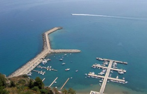
[[Image:CefaluHarbour.jpg|300px|thumb|right|The Porto Nuovo at Cefalu<br/>''Click for larger view'']] | [[Image:CefaluHarbour.jpg|300px|thumb|right|The Porto Nuovo at Cefalu<br/>''Click for larger view'']] | ||
| + | {{TOCleft}} | ||
==Charts== | ==Charts== | ||
| - | British Admiralty 1976 - Capo di Bonifati to Capo San Vito | + | * British Admiralty 1976 - Capo di Bonifati to Capo San Vito |
| - | + | * Italian chart 916 | |
| - | Italian chart 916 | + | |
==Radio Nets== | ==Radio Nets== | ||
| Line 28: | Line 28: | ||
==Local Weather== | ==Local Weather== | ||
| - | The prevailing wind on the north coast of Sicily during the summer is a NW seabreeze, which rarely gets up much above force 4-5. While infrequent, gales are not unknown during the spring and early summer and send a heavy swell down onto the north coast. In winter, the ''gregale'' is a strong NE wind that can affect the whole of the island and blow for several days. | + | The prevailing wind on the north coast of [[Sicily]] during the summer is a NW seabreeze, which rarely gets up much above force 4-5. While infrequent, gales are not unknown during the spring and early summer and send a heavy swell down onto the north coast. In winter, the ''gregale'' is a strong NE wind that can affect the whole of the island and blow for several days. |
Sources for weather forecasts: | Sources for weather forecasts: | ||
| - | + | * There is a continuous (computerised voice) weather forecast on VHF 68 - first in Italian and then followed with an English translation. | |
| - | + | * The same forecast is given in Italian and English on VHF coastal stations following a notification on channel 16. | |
| - | + | * Navtex weather forecasts are broadcast from stations at Roma, Cagliari ([[Sardinia]]) and Augusta ([[Sicily]]). | |
| - | + | ||
| - | + | ||
| - | + | ||
==Approach and Navigation== | ==Approach and Navigation== | ||
| Line 42: | Line 39: | ||
==Check-in facilities (for Customs and Immigration)== | ==Check-in facilities (for Customs and Immigration)== | ||
| - | Yachts berth on the three pontoons running out from the shore in the centre of the harbour, between the mole and the concrete T-jetty at the southern end of the harbour. Berthing here is managed by the Società L'Ormeggio e Allegra. There are further berths on the two pontoons extending from the northern mole, which are managed by the Società Eolo. There are a total of 300 berths on laid moorings, 40 of which are supposedly reserved for yachts in transit. Maximum length 40 metres. Depths and the piers range from 3.0 to 5.0 metres. Berths on the concrete T-shaped jetty are reserved for fishing vessels and members of the Cefalu Sailing Club. Shelter in the harbour is good with W or NW winds, but any strong onshore winds make it extremely uncomfortable in the reflected swell. A strong NE gregale would probably make Cefalu untenable. | + | Yachts berth on the three pontoons running out from the shore in the centre of the harbour, between the mole and the concrete T-jetty at the southern end of the harbour. Berthing here is managed by the Società L'Ormeggio e Allegra. There are further berths on the two pontoons extending from the northern mole, which are managed by the Società Eolo. There are a total of 300 berths on laid moorings, 40 of which are supposedly reserved for yachts in transit. Maximum length 40 metres. Depths and the piers range from 3.0 to 5.0 metres. Berths on the concrete T-shaped jetty are reserved for fishing vessels and members of the Cefalu Sailing Club. Shelter in the harbour is good with W or NW winds, but any strong onshore winds make it extremely uncomfortable in the reflected swell. A strong NE ''gregale'' would probably make Cefalu untenable. |
==Offshore Islands and Groups== | ==Offshore Islands and Groups== | ||
| Line 53: | Line 50: | ||
==Anchorages== | ==Anchorages== | ||
* In settled weather only, anchor off the old harbour on the west side of the promontory. You will be dropping anchor in 3.0 - 5.0 metres. The holding is good in mud and sand. | * In settled weather only, anchor off the old harbour on the west side of the promontory. You will be dropping anchor in 3.0 - 5.0 metres. The holding is good in mud and sand. | ||
| - | |||
* With W or NW winds, it is possible to anchor with care east of the oil jetty to the south of the marina berths. Depths here are 6.0 - 7.0 metres. Holding reasonable in mud and weed. | * With W or NW winds, it is possible to anchor with care east of the oil jetty to the south of the marina berths. Depths here are 6.0 - 7.0 metres. Holding reasonable in mud and weed. | ||
| Line 111: | Line 107: | ||
* | * | ||
* | * | ||
| + | |||
==External Links== | ==External Links== | ||
Links to relevant websites. | Links to relevant websites. | ||
* | * | ||
* | * | ||
| + | |||
==References & Publications== | ==References & Publications== | ||
Publications, Guides, etc. | Publications, Guides, etc. | ||
* | * | ||
* | * | ||
| + | |||
==''Last Visited & Details Checked (and updated here)''== | ==''Last Visited & Details Checked (and updated here)''== | ||
''Date of member's visit to this Port/Stop & this page's details validated'': | ''Date of member's visit to this Port/Stop & this page's details validated'': | ||
Revision as of 17:32, 12 November 2010
Cefalu, Sicily, Italy
| | |
| | 38°02.12′N, 14°02.20′E |
|---|---|
| | [ Photo gallery] |
| | [ Local chartlet] |
The town and marina of Cefalu are situated roughly in the centre of the N coast of Sicily, around 35 miles E of Palermo. Originally a defensive settlement on the huge rock that looms over the town (Cefalu = Greek headland), the town was re-established at the foot of the bluff by the 12th century Normans, who also constructed the tiny harbour west of the town and the magnificent cathedral that towers over it. Today, cruising yachtsmen visiting the town are better served by the pontoons in the Porto Nuovo, a purpose-built harbour constructed on the more sheltered eastern side of the headland. The town itself is one of the most atmospheric in the whole of the island, its picturesque fishermen's houses huddled around the old harbour, and is justifiably one of Sicily’s most popular tourist destinations.
Charts
- British Admiralty 1976 - Capo di Bonifati to Capo San Vito
- Italian chart 916
Radio Nets
Also see World Cruiser's Nets
Local Weather
The prevailing wind on the north coast of Sicily during the summer is a NW seabreeze, which rarely gets up much above force 4-5. While infrequent, gales are not unknown during the spring and early summer and send a heavy swell down onto the north coast. In winter, the gregale is a strong NE wind that can affect the whole of the island and blow for several days.
Sources for weather forecasts:
- There is a continuous (computerised voice) weather forecast on VHF 68 - first in Italian and then followed with an English translation.
- The same forecast is given in Italian and English on VHF coastal stations following a notification on channel 16.
- Navtex weather forecasts are broadcast from stations at Roma, Cagliari (Sardinia) and Augusta (Sicily).
The huge bluff that looms over Cefalu is visible from several miles off. The Porto Nuovo is situated immediately west of the bluff, sheltered by a long breakwater extending ESE from the shore. There are depths of 5.0 - 6.0 metres in the entrance. Beware of rocks around the end of the breakwater and others on the southern side of the harbour.
Check-in facilities (for Customs and Immigration)
Yachts berth on the three pontoons running out from the shore in the centre of the harbour, between the mole and the concrete T-jetty at the southern end of the harbour. Berthing here is managed by the Società L'Ormeggio e Allegra. There are further berths on the two pontoons extending from the northern mole, which are managed by the Società Eolo. There are a total of 300 berths on laid moorings, 40 of which are supposedly reserved for yachts in transit. Maximum length 40 metres. Depths and the piers range from 3.0 to 5.0 metres. Berths on the concrete T-shaped jetty are reserved for fishing vessels and members of the Cefalu Sailing Club. Shelter in the harbour is good with W or NW winds, but any strong onshore winds make it extremely uncomfortable in the reflected swell. A strong NE gregale would probably make Cefalu untenable.
Offshore Islands and Groups
Marinas & Yacht Clubs
- Vela Club Cefalù (Sailing Club Cefalu)
Anchorages
- In settled weather only, anchor off the old harbour on the west side of the promontory. You will be dropping anchor in 3.0 - 5.0 metres. The holding is good in mud and sand.
- With W or NW winds, it is possible to anchor with care east of the oil jetty to the south of the marina berths. Depths here are 6.0 - 7.0 metres. Holding reasonable in mud and weed.
Yacht Repairs and Services
Marine Stores
Submit addresses and contact details of marine related businesses that are of interest to cruisers.
Repairs/Yards
Slipway. Mobile crane (10 T). Some wood and fiberglass repairs. Sail repairs. Toilets.
Fuel, Water, & Electricity
Fuel berth on the end of the central pier in the Porto Nuovo (0800 - 2000 summer; 0900 - 1700 winter). Water and electricity on the piers.
Tourism and Things to do Ashore
Tourism
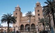
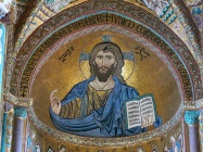
The old town is a delightfully picturesque spot, with narrow, multi-storey fishermen’s cottages wedged together overlooking a sandy beach covered with small brightly painted fishing boats. Cefalu Cathedral is, like most Norman architecture, massive and imposing, its twin towers being visible from several miles offshore. The glory of the interior is the magnificent Byzantine-style mosaics adorning the apse and choir, including a magnificent Christos Pantokrator with remarkably lifelike features. If you are energetic, the climb up to the top of the rock is rewarded with magnificent views. There are also Hellenic and Byzantine remains to explore. With transport, it is possible to visit the shrine of Gibilmanna, set on a peak high above Cefalu, which contains an altar with a miraculous Virgin statue that restored sight and hearing to two blind and one deaf person on its consecration in 1760. Nowadays it is an important pilgrimage centre. Further inland is the spectacular mountain scenery of the Madonie National Park with its pretty mountain villages of Petralia Sottana and Petralia Soprana.
Grocery & Supply Stores
Good provisions shops in the town, but some distance away.
Eateries
Numerous restaurants and cafes along the waterfront of the old town; some very good others mediocre. Several restaurants specialist in the local dish of spaghetti con sarde (with sardines, fennel, pine nuts, raisins and garlic).
Internet/WiFi
No.
Laundry
Motorbike & Car Rentals
Garbage Disposal
Bins in the harbour.
Transportation
Transportation (local and/or international)
Routes/Passages To/From
Popular passages/routes, timing, etc.
Cruiser's Friends
Contact details of "Cruiser's Friends" that can be contacted for local information or assistance.
Forum Discussions
List links to discussion threads on partnering forums. (see link for requirements)
External Links
Links to relevant websites.
References & Publications
Publications, Guides, etc.
Last Visited & Details Checked (and updated here)
Date of member's visit to this Port/Stop & this page's details validated:
- May 2004 --Athene of Lymington 16:50, 12 November 2010 (UTC)
Personal Notes
Personal experiences?
| |
|---|
| | HOMEPAGE | Wiki Contents | Mediterranean | Italy | Sicily | Cefalu | |
.
