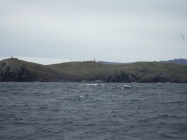
Circuito Cabo de Hornos
From CruisersWiki
CIRCUITO CABO DE HORNOS
Description
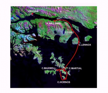
Circuit Cabo de Hornos is crossed by nearly all boats that reach Puerto Williams or Ushuaia. The starting point is necessarily Puerto Williams as the circuit is in Chilean waters and the Zarpe must be obtained from Capitania de Puerto in P.to Williams. Cabo de Hornos is located at the south of the island of the same name that is part of an archipelago. The navigation of 100 nm to go and 90 nm to return occurs in partially protected waters, but should not be underestimated because the winds can be very strong and in the anchorages the wind blow with violence. You can stop only in the allowed anchorages which are listed below with a brief description for each. You must contact with VHF the Alcamars along the way, well-located and attentive listening and assistance to yachts. The circuit can be covered in four/five days excluding any stop, to put into account, due to bad weather. There are not possible supplies of any kind along the way, except water in Puerto Toro.
Climate & Weather Information
Beagle Channel weather forecast sources
Argentina weather forecast sources
Chile weather forecast sources
Weather Windows
You should closely monitor the weather and take advantage of any windows of wind manageable as they arise. Some times north winds arrives that will last briefly and are useful for a rapid descent to the south. It is rare but not impossible to obtain a suitable window to accomplish all the way without waiting. More likely to take advantage of two or more good weather intervals waiting in authorized bays.
Radio Nets
Argentina radio nets
Chile radio nets
Also see World Cruiser's Nets.
Alcamar along the way, listening VHF Ch.16. You must communicate daily the anchorage point and yours movements and contact any Alcamar when sailing in their area:
- [[PUERTO WILLIAMS RADIO]] Template:Poi coord
- [[ALCAMAR TORO]] Template:Poi coord
- [[PICTON RADIO]] Template:Poi coord
- [[ALCAMAR LENNOX]] Template:Poi coord
- [[ALCAMAR WALLASTON]] Template:Poi coord
- [[ALCAMAR HORNOS]] Template:Poi coord
Argentina: which charts and where to buy
Chile: which charts and where to buy
Below is a selection of Chilean Charts:
- Hinstituto Hydrografico Chile
- 13100 - Canal Beagle Canal Murray a Puerto Williams - scale 1:80.000
- 13300 - Canal Beagle e Islas al Sur - scale 1:80.000
- 13620 - Isla Hermite - scale 1:40.000
Possible Departure Points
- [[PUERTO WILLIAMS (CHILE)]] Template:Poi coord- Transporte Contramaestre Micalvi in P.to Williams
Route/Suggested Stopovers
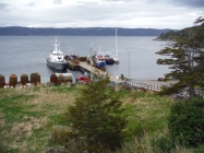
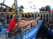
- [[PUERTO TORO]] Template:Poi coord - Port with pier used by local fishermens of king crabs (centollas), a nice stopping point.
- [[CALETA LENNOX]] Template:Poi coord - Anchorage with good protection from winds from the west and south. It hosts Alcamar Lennox, there is pier possibly approachable from the yachts in case of need
- [[CALETA MAXWELL]] Template:Poi coord - Good anchorage (it is called Puerto) near Cabo de Hornos and well protected from all winds, but infested by extensive stands of kelp. Frequently used in the forward path because it allows to double Cape Horn in the direction of prevailing winds from west to east
- [[CALETA LEON (C.HORNOS)]] Template:Poi coord - Bad anchorage but protected from the winds from the south and west, used only to land on the Island of Cabo de Hornos. It is absolutely necessary to leave a person on watch aboard
- [[CALETA MARTIAL]] Template:Poi coord - Anchorage near Cabo de Hornos and well protected from the south and west winds. Frequently used in the return path
Possible Arrival Ports
- [[PUERTO WILLIAMS (CHILE)]] Template:Poi coord - Moor to Transporte Contramaestre Micalvi
Distance & Duration
| [[P.Toro]] | [[C.Lennox]] | [[C.Maxwell]] | [[C.Leon (C.Hornos)]] | [[C.Martial]] | [[C.Lennox]] | [[P.Toro]] | [[P.Williams]] | |
| [[P.Williams]] | 25 0+4 | 42 0+7 | 84 0+14 | 102 0+17 | 114 0+19 | 151 1+1 | 168 1+4 | 193 1+8 |
These table for omogeneity with other template, but it is a non-sense for this circuit. The duration days are 4 to 5 plus the days waiting good weather at anchor.
Forum discussions
List links to discussion threads on partnering forums. (see link for requirements)
External Links
List links external to the wiki such as in Wikipedia.
References
- Patagonia & Tierra del Fuego Nautical Guide, 2nd Ed. by Mariolina Rolfo & Giorgio Ardrizzi
- Andrew O'Grady from original material by Ian and Maggy Staples, Chile Arica Desert to Tierra del Fuego, RCC Pilotage Foundation, ISBN 0852887213
Personal Notes
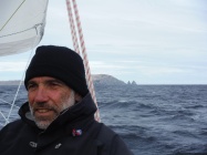
Sailed from Venice (Italy) april, 1 2014 Danbag reached with its S/Y Shaula 3 Cabo de Hornos november, 27 2014 with a 8 months navigation. I stopped in Puerto Williams for 1 month before sailing the Circuito Cabo de Hornos and I enjoied the impressive nature scenery around and the relaxed hospitality of Micalvi in a period of little inflow of boats (october and the first half of november). During my navigation to Cabo de Hornos I must wait two days anchored in Caleta Lennox with a wind of 40 knots, but after I was luky with nord wind and from Lennox I made the circuit till Caleta Martial, from here to Puerto Toro and after Puerto Williams. The total time was 7 days, 5 of navigation and 2 of waiting in C.ta Lennox.
| This is a usable page of the cruising guide. However, please contribute if you can to help it grow further. Click on Comments to add your personal notes on this page or to discuss its contents. Alternatively, if you feel confident to edit the page, click on the edit tab at the top and enter your changes directly. |
| |
|---|
|
Names: Danbag |
| Cruising Wiki Navigation
|
|---|
| | HOMEPAGE | Wiki Contents | South America | South Atlantic | Chile | CIRCUITO CABO THE HORNOS | |
