Colombia
From CruisersWiki
Colombia
| Colombia | |
 Colombia | |
 Flag | |
| Capital: | Bogota |
|---|---|
| Language: | Spanish |
| Currency: | Colombian Peso |
| More notes about the country | |
Background
Some history about the country needs to be submitted here.
Climate & Weather
Submit the climate details and sources of weather forecasting here.
Charts
Submit details of the charts required for safe navigation of the area.
Any navigation notes here.
Local Radio Nets
Submit details of Cruiser's Nets and VHF operating/calling channels here.
Arrival/Departure procedures
Submit any details about advance notification of arrival, etc.
Immigration & Customs
Submit details about customs and immigration procedures here.
Visas
Submit information about what visitor's visas are available and where they are obtained.
Health & Security
Submit any health warnings/information and any security details here.
Ports & Popular Stops
Submit Ports and stop-overs
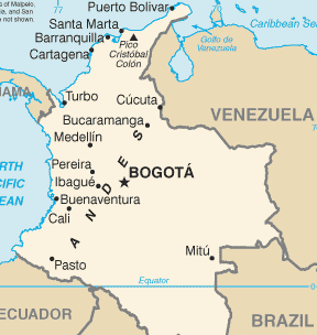
- Caribbean Coast (taken from East to West)
- Make landfall after a trip from the ABCs at Bahia Honda. There is minimal anchorage at Bahia Honda in the lee of Punta Soldado.
A few miles west is Pto. Bolivar coaling station with heavy commercial traffic but no pleasure boat facilities. Then several miles farther is Cabo Vela. South of Cabo Vela is several miles of west facing beach which is excellent anchorage for transiting boats. There is a fishing village in the region and visitors may be greeted by curious fishermen. 125 miles west of Cabo Vela is a rocky section of coast called the Five Bays. In between offshore of Riohacha there are two oil platforms that must be given five miles sea room per Colombian Guarda Costa rules. A rhumb line transit from Cabo Vela to Five Bays will keep voyagers well clear.
- The middle of the five bays shelters the small village of Guyraca, and the home of Reynaldo Garcia - a long time friend to passing
sailors. Just around the corner (possible to pass inshore of the rocks at Pta Aguja but hair-raising if the current is running), is the town of Santa Marta. This is a potential check-in port, but has been rarely used by visiting sailors. In recent years, the Guarda Costa there has been hailing all passing sailboats to track movement - very courteous.
- West of the five bays about 80 miles is Barranquilla and the mouth of the Rio Magdalena. This is a busy commercial port and not
a yachting destination. There has been much speculation about debris carried out to sea by this large river, but we have seen only lots of muddy water and the odd line of foam in our four passages through the area.
- Beyond Barranquilla a few miles is Punta Hermosa. The town of Pto Colombia was formerly a major port on this coast and protected by
Isla Verde, but the island is gone and the town has no harbor anymore. At Pta Hermosa to the west, there is a large sandbar not shown on older charts. Pta Hermosa has been the location of several piracy incidents against yachts in the past decade and should be given wide berth.
- 30 or so miles west of Pta Hermosa is a potential rest stop at Pta Galera. We anchored there once on an eastward trek. It was rolly
but good for a night's sleep.
- The end of the northwest facing coast of Colombia is Punta Canoas. It has shoal water for more than half a mile to the northwest
and west. South of the point, there is plenty of anchorage, but few stop there because it is only about 10 miles farther south to the Boca Grande entrance to Cartagena.
- A separate entry is needed for Cartagena - very popular destination and much to be said of it.
- 20 miles southwest of Cartagena are the Rosario group of islands. Lightly settled and formerly the abode of drug kingpins. The main
attraction of these overfished reefs are the Oceanario (a sea aquarium) and a free aviary on the southwest corner of the largest island (Isla Grande). The island "Isla Rosario" which is southwest of the rest of the archipelago is off limits as a nature reserve.
- 20 miles south along the coast from the Rosarios are the San Bernardo group of islands. Some have resort facilities and others are
deserted. Punta San Bernardo on the mainland offers excellent protection in the waters south and east of the point.
- 35 miles southwest of Pta San Bernardo is Isla Fuerte. This small island has a fishing village on the southeast corner and numerous
vacation villas around the rest of the island. There are cock fights on Friday nights. Anchor off the village, around on the southwest side if the wind is strong from the north or NE (rare), or along the east side but beware in the latter location of scattered large boulders rising to 5 foot depth in water of 10 foot depth all about.
- the end of the Colombian coast on the Caribbean side is the enchanting village of Sapzurro (Zapzurro) at the border with Panama.
There are no roads to this town of very friendly people. There is a nice hike up the power line route to the next village south at least to the overlooking ridge above the village (as far as we went - took about 45 minutes for the hike up through lush rain forest).
- Pacific Coast
Offshore Islands
Details?
Cruiser's Friends
Submit details/contacts of cruiser's "friends" that can be contacted in advance or on arrival - who can offer information and assistance to our cruising "family".
References & Publications
Books, etc.
Links to CruiserLog Forum discussions
Links to discussions on the CruiserLog Forum
External Links
Submit useful website links for the region
Personal Notes
Personal experiences?
.