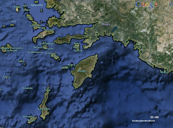
Dodecanese
From CruisersWiki
Dodecanese Cruising Guide
An online cruising guide for yachts sailing around the Dodecanese.
Dodecanese (Δωδεκάνησα - 12 islands) is a group of islands in the SE Aegean. It actually consists, despite its name, of 163 islands of which 26 are inhabited. It is a prefecture of Greece and its capital is Rhodes.
In the early Bronze Age the Dodecanese were dominated by the Minoans from Crete and later, about 1400 BC, by the Achaeans, the people of the Iliad and the Odyssey. In Classical times the islands, many of them inhabited by Dorian Greeks, played a role in the Persian Wars. They have been invaded and dominated by the Persians, Macedonians, Romans, Byzantines, Crusaders, Genovese, the Knights of St. John, the Ottomans, and in the 20th century by the Italians under Mussolini. Finally in 1947 they became part of Greece.
For historical details see the pages of individual islands.
For the cruiser, there are many interesting sight-seeing sites as well as many anchorages. From the popular Rhodes and Kos with strong archaelogical interest, to the volcanic Nisyros, and to the almost uninhabited Levitha and Syrna.
Cruising the region
The best times to tour the Dodechanese are in the Spring, May to June, and in the autumn, September to October. You are less likely to encounter strong meltemi winds and also all the anchorages are less crowded. Other than the weather-wise unpredictable winter months, the worse time to be cruising the Sea of Samos is during the month of August. In August not only will you encounter a number of meltemi gales but all harbors and anchorages, even the most remote, will be crowded as this is the prime vacation time in Greece and the rest of the EU.
In October, especially late in the month there can be southerly winds and occasionally thunderstorms, some of which can be severe. If you are cruising during that time you should always have two possible anchorages in mind: one protected from N winds and one from the S winds.
- BA
- 236 Hisurönü Körfezi to Taslik Burnu including Rhodos
- 872 Kalimno to Rhodes
- 1040 Nísos Íos to Vrakhonisídha Kandhelioússa
- 1055 Rhodes Channel and Gökova Körfezi
- 1546 Samos Strait to Güllük Körfezi
- 1604 Gulf of Kos, Doris and Simi
- 1667 Rhodes Island
- 2682 Kolpos Patalion to Nisos Nisiros
- 2824 Scarpanto (Karpathos) and Kasos islands
- 3922 Astipalia (Stampalia) Island
- 3923 Niseros and Adjacent Islands
- 3926 Lero island and approaches
- 3927 Patmos, Arki and Lipso
- Imray-Tetra
- G32 Eastern Sporades, Dodecanese & the Coast of Turkey
- G34 Southern Cyclades
- G35 Dodecanese and the Coast of Turkey
- G36 Marmaris to Kekova Adasi
- NIMA
- 54400 Nisos Samos to Nisos Rhodhos
- 54403 Samos Strait to Nisos Kalolimnos
- 54407 Nisos Kalymnos to Kadriga Burnu
- 54408 NIsos Kos To Nisos Tilos
- 54410 Nisos Astipalaia
- 54412 Nisos Amorgos & Plans in Astipalaia
- 54416 Nisos Rodhos
- 54420 Iskandil Burnu to Dildarde Burnu
- Greek
- 42 Andros to Chalki Island
- 422 Naxos to Samos & Opposite Coast of Asia Minor
- 423 Paros to Astypalia
- 451 Leros to Rhodos
- 452 Rhodos to Castelorizo
Weather and Winds
In the summer months the weather is dominated by the meltemi which comes from the NW.
For details see Aegean Weather.
Currents & Tides
The Dodecanese experience weak currents and low tides.
Regional Radio Nets
See Aegean Sea.
Also see World Cruiser's Nets.
Islands in the Group
![]() = Port of entry,
= Port of entry, ![]() = Marina,
= Marina, ![]() = Harbor,
= Harbor, ![]() = Anchorage,
= Anchorage, ![]() = Needs data.
= Needs data.
Things to do Ashore
See individual islands.
Routes/Passages To/From
Cruiser's Friends
Contact details of "Cruiser's Friends" that can be contacted for local information or assistance.
Forum Discussions
List links to discussion threads on partnering forums. (see link for requirements)
External Links
- Dodecanese (Wikipedia)
Also see Aegean Sea.
References & Publications
See Aegean Sea.
Personal Notes
Personal experiences?
- I have sailed to all of this islands. --Istioploos

Last Visited & Details Checked (and updated here)
Date of member's visit to this Island Group & this page's details validated:
- October 2012 --Istioploos

|
|---|
|
Names: Istioploos |
| |
|---|
| | HOMEPAGE | Wiki Contents | Mediterranean | Aegean Sea | Greece | Dodecanese | |
