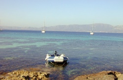
Elafonisos
From CruisersWiki
Istioploos (Talk | contribs) (Coords & Edits) |
Istioploos (Talk | contribs) (Re-format) |
||
| Line 1: | Line 1: | ||
==Elafonisos== | ==Elafonisos== | ||
| - | + | {| class="infobox bordered" style="width: 33em; text-align: left; font-size: 85%;" | |
| - | <center>< | + | |- |
| - | + | | colspan="2" style="text-align:center; font-size: smaller;" | {{Small info}} (''Click links for more information'') | |
| - | + | |- | |
| - | + | ! <center>[[image:World_icon.png]]</center> | |
| + | | {{Coord|36|30.62|N|22|58.96|E|}} | ||
| + | |- | ||
| + | ! <center>[[image:Photo_icon.png]]</center> | ||
| + | | [http://www.panoramio.com/map/#lt=36.510333&ln=22.982667&z=5&k=0&a=1&tab=2 Photo gallery] | ||
| + | |- | ||
| + | ! <center>[[image:Chart_icon.png]]</center> | ||
| + | | [http://mapserver.mytopo.com/homepage/index.cfm?lat=36.510333&lon=22.982667&scale=750000&zoom=100&type=0&icon=0&searchscope=dom&CFID=17583484&CFTOKEN=79232580&scriptfile=http://mapserver.mytopo.com/homepage/index.cfm&latlontype=DMS Local chartlet] | ||
| + | |} | ||
| - | |||
| - | |||
| - | |||
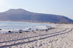
The island of [http://en.wikipedia.org/wiki/Elafonisos Elafonisos] or Elaphonisos (Ελαφόνησος) is a sparsely populates island near [http://en.wikipedia.org/wiki/Cape_Malea Cape Maleas] on the SE of [http://en.wikipedia.org/wiki/Peloponnese Peloponnesos]. There is only a small village on the island. The beaches of the S side of the island have rather impressive sand dunes. The dune area was until few years ago completely deserted but now it has been "discovered" and now there is a dirt road form the village to the S. side and in the delicate sand dunes house tents and even worse are scared by tire marks. What a shame! | The island of [http://en.wikipedia.org/wiki/Elafonisos Elafonisos] or Elaphonisos (Ελαφόνησος) is a sparsely populates island near [http://en.wikipedia.org/wiki/Cape_Malea Cape Maleas] on the SE of [http://en.wikipedia.org/wiki/Peloponnese Peloponnesos]. There is only a small village on the island. The beaches of the S side of the island have rather impressive sand dunes. The dune area was until few years ago completely deserted but now it has been "discovered" and now there is a dirt road form the village to the S. side and in the delicate sand dunes house tents and even worse are scared by tire marks. What a shame! | ||
| - | + | [[Image:Elafonisos2.jpg|250px|thumb|center|The Ravaged Sand Dunes<br/>''Click for larger view'']] | |
| - | + | ||
| - | + | ==Charts== | |
| + | [[Image:Greece_S_PelopS.jpg|350px|right|thumb|Satellite View of Southern Peloponnese<br/>''Click for larger view'']] | ||
| - | + | [[Image:Greece_Elafonisos_m.jpg|350px|right|thumb|Chart of Elafonisos<br/>''Click for larger view'']] | |
| - | Greek 43 Kriti I. - Wastern Part Cape Tainaro to Milos I. | + | ; BA |
| + | : 1685 Nisís Venetico to Nísos Spétsai including the channels between Akra Malléas and Kríti Yerakas | ||
| + | ; Imray-Tetra | ||
| + | : G15 Southern Peloponnisos | ||
| + | ; NIMA | ||
| + | : 54303 Lakonikos Kolpos | ||
| + | ; Greek | ||
| + | : 43 Kriti I. - Wastern Part Cape Tainaro to Milos I. | ||
| - | + | ==Radio Nets== | |
''Also see [[HF_Radio|Cruiser's Nets]]'' | ''Also see [[HF_Radio|Cruiser's Nets]]'' | ||
* Coast Guard - VHF channel 12 | * Coast Guard - VHF channel 12 | ||
* Olympia Radio - VHF channels 85 & 86 | * Olympia Radio - VHF channels 85 & 86 | ||
| - | + | ==Weather== | |
The winds here during the May - October period tend to be from the NE seldom exceeding force 4. During the November -April period they are from the SE often at gale force. But, because of the high mountains, there can be ferocious gusts especially near Capes Tainaron and Maleas. There is a popular Greek proverb among sailors: "Από τον Κάβο Μαλιά δέκα μιλια μακρυά, κι’ από τον Κάβο Γκροσσο δέκα κι’ άλλα τόσο" ("Stay ten miles off Cape Malea, and from Cape Grosso ten and then ten more"). | The winds here during the May - October period tend to be from the NE seldom exceeding force 4. During the November -April period they are from the SE often at gale force. But, because of the high mountains, there can be ferocious gusts especially near Capes Tainaron and Maleas. There is a popular Greek proverb among sailors: "Από τον Κάβο Μαλιά δέκα μιλια μακρυά, κι’ από τον Κάβο Γκροσσο δέκα κι’ άλλα τόσο" ("Stay ten miles off Cape Malea, and from Cape Grosso ten and then ten more"). | ||
Another problem here is that the weather, because of moving depressions between Maleas and [[Crete]], can deteriorate very quickly especially during the spring and fall months. During the summer months there can be thunderstorms and squalls near the shore. | Another problem here is that the weather, because of moving depressions between Maleas and [[Crete]], can deteriorate very quickly especially during the spring and fall months. During the summer months there can be thunderstorms and squalls near the shore. | ||
| - | + | ==Approach and Navigation== | |
Approaches in general are straightforward. | Approaches in general are straightforward. | ||
| - | + | ==Check-in facilities== | |
| + | None. | ||
| + | |||
| + | ==Ports and Popular Stops== | ||
There are several anchorages in Elaphonisos and one just across the channel on the Peloponnesian coast. However, not all of them are always tenable. | There are several anchorages in Elaphonisos and one just across the channel on the Peloponnesian coast. However, not all of them are always tenable. | ||
| - | ===Ports | + | ===Ports=== |
====Elafonisos Village==== | ====Elafonisos Village==== | ||
[[Image:Elafonisos3.jpg|250px|thumb|right|The Village of Elafonisos<br/>''Click for larger view'']] | [[Image:Elafonisos3.jpg|250px|thumb|right|The Village of Elafonisos<br/>''Click for larger view'']] | ||
| - | + | [[image:World_icon.png]] {{Coord|36|30.62|N|22|58.96|E|}}<br> | |
There is a very small harbor in the village. You can either go stern or bows-to the quay, if there is room, or anchor off in the middle of the bay in 3 m depth. Holding is reported to be bad. | There is a very small harbor in the village. You can either go stern or bows-to the quay, if there is room, or anchor off in the middle of the bay in 3 m depth. Holding is reported to be bad. | ||
====Neapolis==== | ====Neapolis==== | ||
| - | + | [[image:World_icon.png]] {{Coord|36|30.5|N|23|03.3|E|}}<br> | |
Neapolis (Νεάπολις) is a small harbor across from Elafonisos on the Peloponnesian coast. It is reported to give good shelter but being noisy. | Neapolis (Νεάπολις) is a small harbor across from Elafonisos on the Peloponnesian coast. It is reported to give good shelter but being noisy. | ||
| - | |||
| - | |||
| - | |||
===Anchorages=== | ===Anchorages=== | ||
====Lefkí==== | ====Lefkí==== | ||
[[Image:Elafonisos1.jpg|250px|thumb|right|The Anchorage of Lefkí<br/>''Click for larger view'']] | [[Image:Elafonisos1.jpg|250px|thumb|right|The Anchorage of Lefkí<br/>''Click for larger view'']] | ||
| - | + | [[image:World_icon.png]] {{Coord|36|28.7|N|22|59|E|}}<br> | |
Lefkí (Λευκί) is maybe the best shelter from the meltemi and the prevailing W winds. It is a very pleasant isolated anchorage. The bottom is rocky with sandy areas. It is best to anchor near the S side of the cove. Once the anchor is set on sand the holding is good. I have been here during strong winds, upper 30's, and the sea was flat. | Lefkí (Λευκί) is maybe the best shelter from the meltemi and the prevailing W winds. It is a very pleasant isolated anchorage. The bottom is rocky with sandy areas. It is best to anchor near the S side of the cove. Once the anchor is set on sand the holding is good. I have been here during strong winds, upper 30's, and the sea was flat. | ||
| Line 65: | Line 77: | ||
There are a few places on the W coast where one can anchor, if the weather permits. | There are a few places on the W coast where one can anchor, if the weather permits. | ||
| - | === | + | ==Marinas & Yacht Clubs== |
| + | None. | ||
| + | |||
| + | ==Yacht Services and Repairs== | ||
| + | ====Marine Stores==== | ||
None. | None. | ||
| - | === | + | ====Yacht Services/Repairs/Yards==== |
| - | + | None. | |
| - | === | + | ====Fuel, Water, & Electricity==== |
| - | + | ; Fuel | |
| + | : N/A (Not Available) | ||
| + | ; Water | ||
| + | : Near the quay of the [[#Elafonisos_Village|village]] | ||
| + | ; Electricity | ||
| + | : N/A | ||
| - | == | + | ==Offshore Islands== |
| - | * | + | * [[Cythera]] |
| - | + | ||
| - | + | ||
| - | === | + | ==Tourism and Things to do Ashore== |
| - | + | ===Tourism=== | |
| + | Walk along the sand dunes to Sarakino and Frangos, preferably in the evening or early morning. | ||
===Grocery & Supply Stores=== | ===Grocery & Supply Stores=== | ||
| Line 92: | Line 112: | ||
===Internet/WiFi=== | ===Internet/WiFi=== | ||
N/A. | N/A. | ||
| + | |||
| + | ===Laundry=== | ||
| + | N/A | ||
===Motorbike & Car Rentals=== | ===Motorbike & Car Rentals=== | ||
N/A. | N/A. | ||
| - | === | + | ===Garbage Disposal=== |
| - | + | There are bins in the harbor only. | |
| - | + | ||
| - | + | ||
| - | + | ||
===Transportation=== | ===Transportation=== | ||
| Line 106: | Line 126: | ||
* From [[#Neapolis|Neapolis]] taxis to [[Monemvasia|Monemvasía]] and ferries to [[Cythera]] | * From [[#Neapolis|Neapolis]] taxis to [[Monemvasia|Monemvasía]] and ferries to [[Cythera]] | ||
| - | == | + | ==Routes/Passages To/From== |
| - | + | * [[Circumnavigating the Peloponnese]] | |
| - | + | ==Cruiser's Friends== | |
Contact details of "Cruiser's Friends" that can be contacted for local information or assistance. | Contact details of "Cruiser's Friends" that can be contacted for local information or assistance. | ||
| - | + | ==Forum Discussions== | |
List links to discussion threads on the Cruiser Log Forum | List links to discussion threads on the Cruiser Log Forum | ||
* | * | ||
| Line 118: | Line 138: | ||
* | * | ||
| - | + | ==External Links== | |
* [http://en.wikipedia.org/wiki/Elafonisos Elafonisos] | * [http://en.wikipedia.org/wiki/Elafonisos Elafonisos] | ||
* | * | ||
* | * | ||
| - | === | + | ==References & Publications== |
| - | + | ''See [[Greece#References_&_Publications|Greece]]''. | |
| - | + | ||
| - | + | ==Last Visited & Details Checked (and updated here)== | |
''Date of member's visit to this Port/Stop & this page's details validated'': | ''Date of member's visit to this Port/Stop & this page's details validated'': | ||
| - | * September 2007 --[[User:Istioploos|Istioploos]] | + | * September 2007 --[[User:Istioploos|Istioploos]] [[Image:Greece_Icon.png]] |
| + | * | ||
| + | |||
| + | ==Personal Notes== | ||
| + | Personal experiences? | ||
* | * | ||
Revision as of 23:11, 13 January 2010
Elafonisos
| | |
| | 36°30.62′N, 22°58.96′E |
|---|---|
| | Photo gallery |
| | Local chartlet |
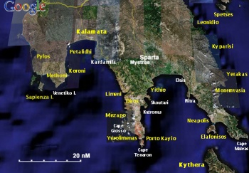
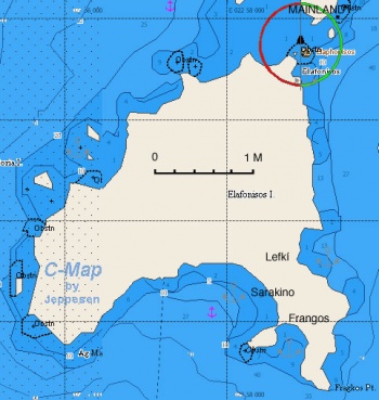
The island of Elafonisos or Elaphonisos (Ελαφόνησος) is a sparsely populates island near Cape Maleas on the SE of Peloponnesos. There is only a small village on the island. The beaches of the S side of the island have rather impressive sand dunes. The dune area was until few years ago completely deserted but now it has been "discovered" and now there is a dirt road form the village to the S. side and in the delicate sand dunes house tents and even worse are scared by tire marks. What a shame!
Charts
- BA
- 1685 Nisís Venetico to Nísos Spétsai including the channels between Akra Malléas and Kríti Yerakas
- Imray-Tetra
- G15 Southern Peloponnisos
- NIMA
- 54303 Lakonikos Kolpos
- Greek
- 43 Kriti I. - Wastern Part Cape Tainaro to Milos I.
Radio Nets
Also see Cruiser's Nets
- Coast Guard - VHF channel 12
- Olympia Radio - VHF channels 85 & 86
Weather
The winds here during the May - October period tend to be from the NE seldom exceeding force 4. During the November -April period they are from the SE often at gale force. But, because of the high mountains, there can be ferocious gusts especially near Capes Tainaron and Maleas. There is a popular Greek proverb among sailors: "Από τον Κάβο Μαλιά δέκα μιλια μακρυά, κι’ από τον Κάβο Γκροσσο δέκα κι’ άλλα τόσο" ("Stay ten miles off Cape Malea, and from Cape Grosso ten and then ten more"). Another problem here is that the weather, because of moving depressions between Maleas and Crete, can deteriorate very quickly especially during the spring and fall months. During the summer months there can be thunderstorms and squalls near the shore.
Approaches in general are straightforward.
Check-in facilities
None.
Ports and Popular Stops
There are several anchorages in Elaphonisos and one just across the channel on the Peloponnesian coast. However, not all of them are always tenable.
Ports
Elafonisos Village
![]() 36°30.62′N, 22°58.96′E
36°30.62′N, 22°58.96′E
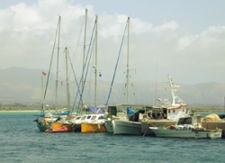
There is a very small harbor in the village. You can either go stern or bows-to the quay, if there is room, or anchor off in the middle of the bay in 3 m depth. Holding is reported to be bad.
Neapolis
![]() 36°30.5′N, 23°03.3′E
36°30.5′N, 23°03.3′E
Neapolis (Νεάπολις) is a small harbor across from Elafonisos on the Peloponnesian coast. It is reported to give good shelter but being noisy.
Anchorages
Lefkí
![]() 36°28.7′N, 22°59′E
36°28.7′N, 22°59′E
Lefkí (Λευκί) is maybe the best shelter from the meltemi and the prevailing W winds. It is a very pleasant isolated anchorage. The bottom is rocky with sandy areas. It is best to anchor near the S side of the cove. Once the anchor is set on sand the holding is good. I have been here during strong winds, upper 30's, and the sea was flat.
Warning: Anchor in either the S or N side of the cove away from the middle where there are rocks.
Sarakino
Sarakino is a large cove on the S side of the island. Its sand dunes make it very attractive. However, every time I have been to the island the cove was exposed to large waves.
Frangos
Frangos is just E of Sarakino on the S of the island. Its sand dunes make it very attractive. However, every time I have been to the island the cove was exposed to large waves.
W Coast
There are a few places on the W coast where one can anchor, if the weather permits.
Marinas & Yacht Clubs
None.
Yacht Services and Repairs
Marine Stores
None.
Yacht Services/Repairs/Yards
None.
Fuel, Water, & Electricity
- Fuel
- N/A (Not Available)
- Water
- Near the quay of the village
- Electricity
- N/A
Offshore Islands
Tourism and Things to do Ashore
Tourism
Walk along the sand dunes to Sarakino and Frangos, preferably in the evening or early morning.
Grocery & Supply Stores
Eateries
- There are several restaurants in the village
Internet/WiFi
N/A.
Laundry
N/A
Motorbike & Car Rentals
N/A.
Garbage Disposal
There are bins in the harbor only.
Transportation
- There are ferries from the village to Neapolis
- From Neapolis taxis to Monemvasía and ferries to Cythera
Routes/Passages To/From
Cruiser's Friends
Contact details of "Cruiser's Friends" that can be contacted for local information or assistance.
Forum Discussions
List links to discussion threads on the Cruiser Log Forum
External Links
References & Publications
See Greece.
Last Visited & Details Checked (and updated here)
Date of member's visit to this Port/Stop & this page's details validated:
- September 2007 --Istioploos

Personal Notes
Personal experiences?
| |
|---|
| | HOMEPAGE | Wiki Contents | Mediterranean | Greece | Elafonisos | |
.
