Giulianova
From CruisersWiki
m (Text replace - "{{Guide1}} {|id="mp-right" width="100%" cellpadding="2" cellspacing="1" style="vertical-align:top; background:#f5faff; border:1px solid #a3b0bf;" ! <h2 id="mp-itn-h2" style="margin:0; background:#cedff2; font-size:120%; font-weight:bold;) |
m (Text replace - "#References & Publications|" to "#References|") |
||
| (38 intermediate revisions not shown) | |||
| Line 1: | Line 1: | ||
| - | + | {{IsPartOf|Mediterranean|Adriatic Sea|Italy|Adriatic Coast of Italy}} | |
| - | {| | + | {{TOC block}} |
| - | | | + | |
| - | | | + | {{Infobox |
| - | + | | lat= 42.7535| lon=13.97583 | |
| - | + | | name= Giulia nova | |
| - | + | | zoom= 15 | |
| - | | | + | | portofentry= |
| - | + | | chartlet = y | |
| - | | | + | | image= GiulianovaAerial.jpg |
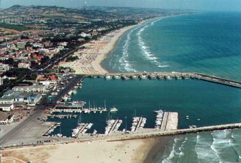
| - | | | + | | imagetext= Giulianova harbour from W |
| - | + | | summary = The town and fishing harbour of Giulianova lie on the Adriatic coast of Italy in the north of the Abruzzo region, around 25 miles NW of the port of Pescara and 15 miles SE of San Benedetto del Tronto. Originally a pre-Roman coastal settlement, the population moved to the hilltop site of Giulianova in the Middle Ages for greater protection from pirate attacks. In more settled times, the population gradually expanded back down to the coast again, a process that culminated in the construction of the modern port in 1913. Today Giulianova harbour is a busy fishing port as well as providing moorings for around 300 leisure vessels on the pontoons and piers at the W and S end of its harbour. | |
| - | | | + | | notes= |
| - | | | + | | news= |
| - | + | }} | |
| - | The town and fishing harbour of Giulianova lie on the Adriatic coast of Italy in the north of the Abruzzo region, around 25 miles NW of the port of | + | |
==Charts== | ==Charts== | ||
| - | British Admiralty 200 | + | ; British Admiralty |
| + | : 200 | ||
| + | ; Italian | ||
| + | : 922 | ||
| + | : 34 | ||
| + | : 214 | ||
| - | + | ==Weather== | |
| + | During the summer months, the prevailing winds in the Adriatic are light to moderate coastal sea breezes. In spring and autumn, northerly winds are more frequent and can quickly rise to near gale force, especially in the northern Adriatic, where the much-feared “bora” is caused by high pressure over the mountains to the NE coupled with low pressure over southern Italy. Fortunately, the fiercest “bora” is normally to be expected in the winter months. Thunderstorms are occasionally experienced in spring and especially autumn and can be accompanied by violent winds of gale force and above. Luckily they are rarely long-lasting. In the southern Adriatic, the “Scirocco”, a S/SE wind blowing up from North Africa which can last for several days, is more common. Unlike the “bora”, which can arrive without warning, a “scirocco” tends to build in strength over 24-48 hours, sometimes reaching gale force (especially in winter). | ||
| - | + | Sources for weather information: | |
| - | + | ||
| - | + | ||
| - | + | * There is a continuous (computerized voice) weather forecast on VHF 68 - first in Italian and then followed with an English translation | |
| - | + | * The same forecast is given in Italian and English on VHF coastal stations following a notification on channel 16 | |
| + | * Navtex weather forecasts covering the Adriatic are broadcast from stations at Roma, Trieste, Kerkyra (Greece) and Split (Croatia) | ||
| - | + | ==Passages== | |
| + | ''See [[Adriatic_Sea#Passages|Adriatic]]''. | ||
| - | + | ==Communication== | |
| + | {{Green|Add here VHF channel for the coastguard, harbor masters. etc.}} | ||
| + | * | ||
| + | * | ||
| - | + | ''Also see [[World MM Nets|World Cruiser's Nets]]''. | |
| - | + | ==Navigation== | |
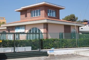
| + | {{Image right| GiulianovaOffice.JPG| The harbour offices }} | ||
| + | The most distinctive feature in the approach to Giulianova is a conspicuous motorway viaduct about a mile NW of the harbour. Once closer in, the breakwaters are easily identifiable. The harbour is entered from NNW, giving the breakwaters a generous clearance in view of ballasting. Depths in the entrance are 5.5 - 6.0 metres, decreasing to 3.0 – 3.5 metres. Entry can be difficult with strong onshore winds and with any significant swell. The area both N and S of Giulanova is littered with numerous lobster pots and a night entry – especially under motor – is very inadvisable. | ||
| - | == | + | ==Berthing== |
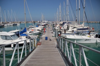
| - | + | {{Image right| GiulianovaPontoon.JPG| Yacht moorings on the municipal pontoons }} | |
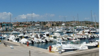
| + | {{Image right| GiulianovaMoorings.jpg| Yacht moorings on the piers }} | ||
| - | + | Visiting yachts normally berth on the three municipal pontoons (A, B and C) on the W side of the harbour, where there are laid mooring lines, water and electricity. The most northerly, shorter pontoon is under concession to the local boatyard, the Cantiere Navale Giulianova. The berths on the concrete piers in the SW corner of the harbour are reserved for members of the ''Circolo Nautico V. Migliori'' and the Italian Lega Navale. The pontoons can accommodate around 150 yachts of up to 22 metres, while the piers have space for a further 150. Depths at the pontoons are 3.5 - 4.0 metres and at the piers 2.5 - 3.0 metres. Shelter in the harbour is good, although strong northerly winds send a surge into the harbour. Toilets and showers in the municipal harbour offices (the squat brick building at the main entrance to the port). A key is required. | |
| - | Visiting yachts normally berth | + | |
| - | + | ||
| - | + | ||
| - | + | ||
| - | ==Marinas & Yacht Clubs== | + | ===Marinas & Yacht Clubs=== |
* Italian Lega Navale | * Italian Lega Navale | ||
* Circolo Nautico V. Migliori | * Circolo Nautico V. Migliori | ||
| Line 52: | Line 59: | ||
No anchoring is permitted in the harbour. | No anchoring is permitted in the harbour. | ||
| - | == | + | ==Amenities== |
| - | + | {{tlist | |
| - | + | ||
| - | + | ||
| - | + | |header|Facilities | |
| - | + | ||
| - | + | |Water| Water on the pontoons and the piers | |
| - | + | |Electricity| Electricity on the pontoons and the piers | |
| + | |Toilets| {{MagentaText|?}} | ||
| + | |Showers| {{MagentaText|?}} | ||
| + | |Laundry| N/A (Not Available) | ||
| + | |Garbage| Bins around the harbour. | ||
| - | + | |header|Supplies | |
| - | + | |Fuel| Fuel station on the quay (0730 - 1230 and 1430 - 1900) | |
| - | + | |Bottled gas| | |
| - | + | |Chandlers| Chandlery at the Cantiere Navale | |
| - | + | |header|Services | |
| - | + | |Repairs| | |
| - | + | Boatyard in the harbour. Slipway. Travel lift (200 T). Mobile crane (40 T). Large area of hard standing. Engine, electrical and electronic repairs. Wood and fiberglass hull repairs. Divers. | |
| - | + | |Internet| Free WiFi from ''Wi4Free'' (requires registration and password sent via SMS) | |
| - | + | |Mobile connectivity| | |
| - | + | |Vehicle rentals| Several rental outlets in the town | |
| - | + | }} | |
| - | + | ||
| - | == | + | ==Provisioning== |
| - | + | Excellent supermarket (Superstore ''Si Con Te'') 10 minutes walk from harbour. Turn right from harbour entrance then immediately left along Via Adriatica – ''Si Con Te'' is 500 metres up this road. | |
| - | == | + | ==Eating out== |
| - | + | Numerous fish and other restaurants along the beach and in the town. | |
| - | + | ==Transportation== | |
| - | + | ||
| - | + | ||
| - | + | ||
* Buses to most local destinations from the town. | * Buses to most local destinations from the town. | ||
* Railway station with connections to most destinations. | * Railway station with connections to most destinations. | ||
| - | * Airport at Pescara (40 kms) with flights to several international destinations. | + | * Airport at [[Pescara]] (40 kms) with flights to several international destinations. |
| - | * Ferries to Vis island, Croatia. | + | * Ferries to [[Vis]] island, [[Croatia]]. |
| - | + | {{hold vertical}} | |
| - | + | ||
| - | + | ||
| - | == | + | ==Tourism== |
| + | ====Places to Visit==== | ||
| + | The picturesque old town is around 15-20 minutes walk uphill from the harbour. There are some remnants of the town’s original 15th century walls and towers (demolished in 1860) and a 15th century octagonal church of San Flaviano with a distinctive cupola. Along the hillside above the old town are a number of impressive if somewhat faded villas surviving from the town’s 19th and 20th century heyday. Giulianova is also handy for a visit to the beautiful Parco Nazionale del Gran Sasso e Monti della Laga 45 kilometers inland, with its three mountain ranges, spectacular hiking trails, remarkably sited castles and abundant wildlife. | ||
| + | |||
| + | {{hgallery| | ||
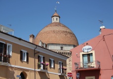
| + | {{himage|GiulianovaOldTown.JPG| Giulianova old town and church cupola}} | ||
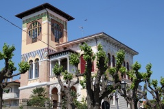
| + | {{himage|GiulianovaVilla.JPG| Giulianova old town contains some fine art deco villas }} | ||
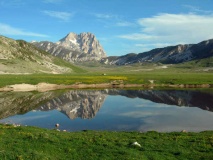
| + | {{himage|GiulianovaParco.jpg| Typical landscape of the Parco Nazionale del Gran Sasso e Monti della La}} | ||
| + | }} | ||
| + | |||
| + | ==Friends== | ||
Contact details of "Cruiser's Friends" that can be contacted for local information or assistance. | Contact details of "Cruiser's Friends" that can be contacted for local information or assistance. | ||
* | * | ||
| - | == | + | ==Forums== |
| - | List links to discussion threads on [[Cruising Forums|partnering forums]]. (see link for requirements) | + | List links to discussion threads on [[Cruising Forums|partnering forums]]. (''see link for requirements'') |
* | * | ||
* | * | ||
| - | |||
| - | |||
| - | |||
| - | |||
| - | |||
| - | == | + | ==Links== |
| - | + | * {{wikipedia}} | |
| - | * | + | * [http://www.giulianovaweb.it/guida/72.htm Giulianova web] |
| - | * | + | * [http://www.giulianova.it/en/ Giulianova] |
| - | == | + | * [http://www.gransassolagapark.it/ Parco Nazionale del Gran Sasso e Monti della Laga] |
| - | '' | + | |
| - | + | ==References== | |
| + | ''See [[Italy#References|Italy]]''. | ||
| + | |||
| + | {{Comments}} | ||
* | * | ||
| - | + | {{Verified by}} | |
| - | + | * May 2015 --[[User:Atheneoflymington|Athene of Lymington]] | |
* | * | ||
| - | {{ | + | {{Page useable}} |
| - | + | {{Contributors|[[User:Atheneoflymington|Athene of Lymington]]}} | |
| - | {| | + | |
| - | + | ||
| - | + | ||
| - | + | ||
| - | + | ||
| - | + | ||
| - | + | ||
| - | + | ||
| - | + | ||
| - | + | ||
| - | + | ||
| - | + | ||
| - | + | ||
| - | + | ||
[[Category:Ports - Italy]] | [[Category:Ports - Italy]] | ||
| - | |||
| - | |||
| - | |||
Latest revision as of 07:45, 21 August 2018
| Giulia nova
| |
| | |
The town and fishing harbour of Giulianova lie on the Adriatic coast of Italy in the north of the Abruzzo region, around 25 miles NW of the port of Pescara and 15 miles SE of San Benedetto del Tronto. Originally a pre-Roman coastal settlement, the population moved to the hilltop site of Giulianova in the Middle Ages for greater protection from pirate attacks. In more settled times, the population gradually expanded back down to the coast again, a process that culminated in the construction of the modern port in 1913. Today Giulianova harbour is a busy fishing port as well as providing moorings for around 300 leisure vessels on the pontoons and piers at the W and S end of its harbour.
Charts
- British Admiralty
- 200
- Italian
- 922
- 34
- 214
Weather
During the summer months, the prevailing winds in the Adriatic are light to moderate coastal sea breezes. In spring and autumn, northerly winds are more frequent and can quickly rise to near gale force, especially in the northern Adriatic, where the much-feared “bora” is caused by high pressure over the mountains to the NE coupled with low pressure over southern Italy. Fortunately, the fiercest “bora” is normally to be expected in the winter months. Thunderstorms are occasionally experienced in spring and especially autumn and can be accompanied by violent winds of gale force and above. Luckily they are rarely long-lasting. In the southern Adriatic, the “Scirocco”, a S/SE wind blowing up from North Africa which can last for several days, is more common. Unlike the “bora”, which can arrive without warning, a “scirocco” tends to build in strength over 24-48 hours, sometimes reaching gale force (especially in winter).
Sources for weather information:
- There is a continuous (computerized voice) weather forecast on VHF 68 - first in Italian and then followed with an English translation
- The same forecast is given in Italian and English on VHF coastal stations following a notification on channel 16
- Navtex weather forecasts covering the Adriatic are broadcast from stations at Roma, Trieste, Kerkyra (Greece) and Split (Croatia)
Passages
See Adriatic.
Communication
Add here VHF channel for the coastguard, harbor masters. etc.
Also see World Cruiser's Nets.
The most distinctive feature in the approach to Giulianova is a conspicuous motorway viaduct about a mile NW of the harbour. Once closer in, the breakwaters are easily identifiable. The harbour is entered from NNW, giving the breakwaters a generous clearance in view of ballasting. Depths in the entrance are 5.5 - 6.0 metres, decreasing to 3.0 – 3.5 metres. Entry can be difficult with strong onshore winds and with any significant swell. The area both N and S of Giulanova is littered with numerous lobster pots and a night entry – especially under motor – is very inadvisable.
Berthing
Visiting yachts normally berth on the three municipal pontoons (A, B and C) on the W side of the harbour, where there are laid mooring lines, water and electricity. The most northerly, shorter pontoon is under concession to the local boatyard, the Cantiere Navale Giulianova. The berths on the concrete piers in the SW corner of the harbour are reserved for members of the Circolo Nautico V. Migliori and the Italian Lega Navale. The pontoons can accommodate around 150 yachts of up to 22 metres, while the piers have space for a further 150. Depths at the pontoons are 3.5 - 4.0 metres and at the piers 2.5 - 3.0 metres. Shelter in the harbour is good, although strong northerly winds send a surge into the harbour. Toilets and showers in the municipal harbour offices (the squat brick building at the main entrance to the port). A key is required.
Marinas & Yacht Clubs
- Italian Lega Navale
- Circolo Nautico V. Migliori
Anchorages
No anchoring is permitted in the harbour.
Amenities
| Facilities | |
|---|---|
| Water | Water on the pontoons and the piers |
| Electricity | Electricity on the pontoons and the piers |
| Toilets | ? |
| Showers | ? |
| Laundry | N/A (Not Available) |
| Garbage | Bins around the harbour. |
| Supplies | |
| Fuel | Fuel station on the quay (0730 - 1230 and 1430 - 1900) |
| Bottled gas | |
| Chandlers | Chandlery at the Cantiere Navale |
| Services | |
| Repairs | Boatyard in the harbour. Slipway. Travel lift (200 T). Mobile crane (40 T). Large area of hard standing. Engine, electrical and electronic repairs. Wood and fiberglass hull repairs. Divers. |
| Internet | Free WiFi from Wi4Free (requires registration and password sent via SMS) |
| Mobile connectivity | |
| Vehicle rentals | Several rental outlets in the town |
Provisioning
Excellent supermarket (Superstore Si Con Te) 10 minutes walk from harbour. Turn right from harbour entrance then immediately left along Via Adriatica – Si Con Te is 500 metres up this road.
Eating out
Numerous fish and other restaurants along the beach and in the town.
Transportation
- Buses to most local destinations from the town.
- Railway station with connections to most destinations.
- Airport at Pescara (40 kms) with flights to several international destinations.
- Ferries to Vis island, Croatia.
Tourism
Places to Visit
The picturesque old town is around 15-20 minutes walk uphill from the harbour. There are some remnants of the town’s original 15th century walls and towers (demolished in 1860) and a 15th century octagonal church of San Flaviano with a distinctive cupola. Along the hillside above the old town are a number of impressive if somewhat faded villas surviving from the town’s 19th and 20th century heyday. Giulianova is also handy for a visit to the beautiful Parco Nazionale del Gran Sasso e Monti della Laga 45 kilometers inland, with its three mountain ranges, spectacular hiking trails, remarkably sited castles and abundant wildlife.
Friends
Contact details of "Cruiser's Friends" that can be contacted for local information or assistance.
Forums
List links to discussion threads on partnering forums. (see link for requirements)
Links
- Giulianova at the Wikipedia
- Giulianova web
- Giulianova
- Parco Nazionale del Gran Sasso e Monti della Laga
References
See Italy.
Comments
We welcome users' contributions to the Wiki. Please click on Comments to view other users' comments, add your own personal experiences or recommend any changes to this page following your visit.
Verified by
Date of member's last visit to Giulianova and this page's details validated:
- May 2015 --Athene of Lymington
| This is a usable page of the cruising guide. However, please contribute if you can to help it grow further. Click on Comments to add your personal notes on this page or to discuss its contents. Alternatively, if you feel confident to edit the page, click on the edit tab at the top and enter your changes directly. |
| |
|---|
|
Names: Athene of Lymington |
