Hisaronu Korfezi to Teke Burnu
From CruisersWiki
m (Text replace - " <small>[''add 3 tildes (<nowiki>~~~</nowiki>) on the name line'']</small>" to "") |
Istioploos (Talk | contribs) (Added contributors and some new material) |
||
| Line 1: | Line 1: | ||
==Hisarönü Körfesi to Teke Burnu== | ==Hisarönü Körfesi to Teke Burnu== | ||
| - | This deep gulf is also known as the Gulf of Doris or the Gulf of Symi. It is very indented and has many lovely anchorages, yet it is not too crowded. | + | This deep gulf is also known as the Gulf of [http://en.wikipedia.org/wiki/Doris_(Asia_Minor) Doris] or the Gulf of [[Symi]]. It is very indented and has many lovely anchorages, yet it is not too crowded. |
| - | + | {{TOCleft}} | |
==Charts== | ==Charts== | ||
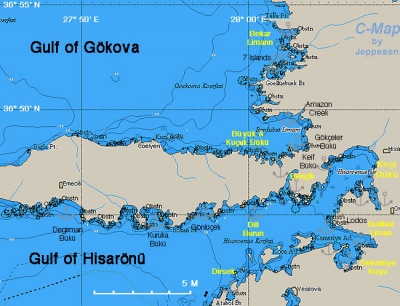
| - | [[Image:Turkey_Bencik_r.jpg| | + | [[Image:Turkey_Bencik_r.jpg|400px|thumb|right|Chart of Hisarönü Region<br />''Click for larger view'']] |
; BA | ; BA | ||
| Line 18: | Line 18: | ||
==Radio Nets== | ==Radio Nets== | ||
| - | ''Also see [[HF_Radio|Cruiser's Nets]]'' | + | ''Also see [[HF_Radio|Cruiser's Nets]]''. |
Submit details of local radio Nets. | Submit details of local radio Nets. | ||
==Local Weather== | ==Local Weather== | ||
| - | ''See [[Turkey#Turkey_Climate_&_Weather|Turkey]]'' | + | ''See [[Turkey#Turkey_Climate_&_Weather|Turkey]]''. |
==Approach and Navigation== | ==Approach and Navigation== | ||
| Line 39: | Line 39: | ||
==Anchorages== | ==Anchorages== | ||
====Dirsek==== | ====Dirsek==== | ||
| - | + | [[image:World_icon.png]] {{Coord|36|41.6|N|27|58.8|E|}} - [http://mapserver.maptech.com/homepage/index.cfm?lat=36.693333&lon=27.98&scale=100000&zoom=100&type=0&icon=0&searchscope=dom&CFID=2448100&CFTOKEN=51416738&scriptfile=http://mapserver.maptech.com/homepage/index.cfm&latlontype=DMS Chartlet]<br /> | |
Dirsek is not a very attractive cove. | Dirsek is not a very attractive cove. | ||
| Line 49: | Line 49: | ||
====Selemiye Koyu==== | ====Selemiye Koyu==== | ||
| - | [[Image:Turkey_Hisaronu_Selemiye_m.jpg|300px|thumb|right|Chart of Selemiye Koyu - [http://mapserver.maptech.com/homepage/index.cfm?lat=36.718333&lon=28.105&scale=24000&zoom=50&type=1 Chartlet]<br/>''Click for larger view'']] | + | [[Image:Turkey_Hisaronu_Selemiye_m.jpg|300px|thumb|right|Chart of Selemiye Koyu - [http://mapserver.maptech.com/homepage/index.cfm?lat=36.718333&lon=28.105&scale=24000&zoom=50&type=1 Chartlet]<br />''Click for larger view'']] |
| - | + | [[image:World_icon.png]] {{Coord|36|43.1|N|28|06.3|E|}}<br /> | |
| - | + | Selemiye Koyu is also known as Port Losta. There are several restaurants in this attractive cove that provide free docking (layed moorings) with water and electricity. The most popular and upscale is Sarunya ([[image:World_icon.png]] {{Coord|36|42.5|N|28|05.3|E|}}). | |
| - | Selemiye Koyu is also known as Port Losta. There are several restaurants in this attractive cove that provide free docking (layed moorings) with water and electricity. The most popular and upscale is Sarunya ( | + | |
=====Last Visited & Details Checked (and updated here)===== | =====Last Visited & Details Checked (and updated here)===== | ||
| Line 58: | Line 57: | ||
* August 2002 --[[User:Istioploos|Istioploos]] [[Image:Greece_Icon.png]] | * August 2002 --[[User:Istioploos|Istioploos]] [[Image:Greece_Icon.png]] | ||
* | * | ||
| + | <div style="clear: both;"></div> | ||
====Cove E of Delikliyol==== | ====Cove E of Delikliyol==== | ||
| - | + | [[image:World_icon.png]] {{Coord|36|43.6|N|28|05.4|E|}} - [http://mapserver.maptech.com/homepage/index.cfm?lat=36.726667&lon=28.09&scale=100000&zoom=100&type=0&icon=0&searchscope=dom&CFID=2448100&CFTOKEN=51416738&scriptfile=http://mapserver.maptech.com/homepage/index.cfm&latlontype=DMS Chartlet]<br/> | |
This is a delightful isolated cove just E of Delikliyol Limani. Anchor in 7 m over sand. | This is a delightful isolated cove just E of Delikliyol Limani. Anchor in 7 m over sand. | ||
| - | |||
=====Last Visited & Details Checked (and updated here)===== | =====Last Visited & Details Checked (and updated here)===== | ||
''Date of member's visit to this Port/Stop & this page's details validated'': | ''Date of member's visit to this Port/Stop & this page's details validated'': | ||
* August 2002 --[[User:Istioploos|Istioploos]] [[Image:Greece_Icon.png]] | * August 2002 --[[User:Istioploos|Istioploos]] [[Image:Greece_Icon.png]] | ||
* | * | ||
| - | |||
| - | |||
====Keçi Bükü==== | ====Keçi Bükü==== | ||
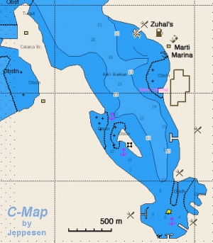
| - | [[Image:Turkey_Hisaronu_Keci_m.jpg|300px|thumb|right|Chart of Keçi Bükü - [http://mapserver.maptech.com/homepage/index.cfm?lat=36.77&lon=28.121667&scale=100000&zoom=100&type=0&icon=0&searchscope=dom&CFID=2448100&CFTOKEN=51416738&scriptfile=http://mapserver.maptech.com/homepage/index.cfm&latlontype=DMS Chartlet]<br/>''Click for larger view'']] | + | [[Image:Turkey_Hisaronu_Keci_m.jpg|300px|thumb|right|Chart of Keçi Bükü - [http://mapserver.maptech.com/homepage/index.cfm?lat=36.77&lon=28.121667&scale=100000&zoom=100&type=0&icon=0&searchscope=dom&CFID=2448100&CFTOKEN=51416738&scriptfile=http://mapserver.maptech.com/homepage/index.cfm&latlontype=DMS Chartlet]<br />''Click for larger view'']] |
| - | + | [[image:World_icon.png]] {{Coord|36|46.2|N|28|07.3|E|}}<br /> | |
| - | + | ||
This lovely bay is dominated by the large [[Marti Marina]]. Call ahead on channel 73. You will be met by a Joker boat at the entrance of the marina and shown to berth. The marina provides all the services. | This lovely bay is dominated by the large [[Marti Marina]]. Call ahead on channel 73. You will be met by a Joker boat at the entrance of the marina and shown to berth. The marina provides all the services. | ||
| Line 87: | Line 83: | ||
* July 2007 --[[User:Atheneoflymington|Atheneoflymington]] 14:43, 26 June 2009 (UTC) | * July 2007 --[[User:Atheneoflymington|Atheneoflymington]] 14:43, 26 June 2009 (UTC) | ||
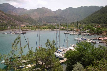
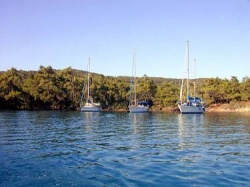
| - | <div style="clear: both;"> | + | <div style="clear: both;">[[Image:Keci.jpeg|350px|thumb|center|Keçi Bükü<br />''Click for larger view'']] </div> |
| - | [[Image:Keci.jpeg|350px|thumb|center|Keçi Bükü]] | + | |
| - | </div> | + | |
====Bencik Liman==== | ====Bencik Liman==== | ||
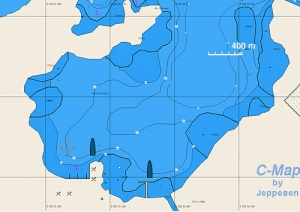
| - | [[Image:Turkey_Hisaronu_Bencik_m.jpg|300px|thumb|right|Chart of Bencik Liman - [http://mapserver.maptech.com/homepage/index.cfm?lat=36.77466453427881&lon=28.039540683799885&scale=100000&zoom=100&type=0&icon=0&width=498&height=498&searchscope=dom&CFID=2448100&CFTOKEN=51416738&scriptfile=http://mapserver.maptech.com/homepage/index.cfm&latlontype=DMS Chartlet]<br/>''Click for larger view'']] | + | [[Image:Turkey_Hisaronu_Bencik_m.jpg|300px|thumb|right|Chart of Bencik Liman - [http://mapserver.maptech.com/homepage/index.cfm?lat=36.77466453427881&lon=28.039540683799885&scale=100000&zoom=100&type=0&icon=0&width=498&height=498&searchscope=dom&CFID=2448100&CFTOKEN=51416738&scriptfile=http://mapserver.maptech.com/homepage/index.cfm&latlontype=DMS Chartlet]<br />''Click for larger view'']] |
| - | + | [[image:World_icon.png]] {{Coord|36|46.9|N|28|02.5|E|}}<br /> | |
| - | + | ||
There are many places to anchor in this deep heavily wooded bay. You will have to anchor fairly deeply in 6-10 m. The holding is good on mud and weed, but the water is murky so that you cannot see the bottom. Take a line to a tree to minimize swinging and interfering with other boats. | There are many places to anchor in this deep heavily wooded bay. You will have to anchor fairly deeply in 6-10 m. The holding is good on mud and weed, but the water is murky so that you cannot see the bottom. Take a line to a tree to minimize swinging and interfering with other boats. | ||
| Line 100: | Line 93: | ||
<font color="red">Warning:</font> Care must be taken entering the bay because of reefs and shallow areas. Study your chart carefully. | <font color="red">Warning:</font> Care must be taken entering the bay because of reefs and shallow areas. Study your chart carefully. | ||
| + | |||
=====Last Visited & Details Checked (and updated here)===== | =====Last Visited & Details Checked (and updated here)===== | ||
''Date of member's visit to this Port/Stop & this page's details validated'': | ''Date of member's visit to this Port/Stop & this page's details validated'': | ||
| Line 108: | Line 102: | ||
====Büyük Cati==== | ====Büyük Cati==== | ||
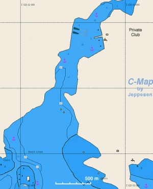
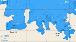
| - | [[Image:Turkey_Hisaronu_BuyukCati_m.jpg|300px|thumb|right|Chart of Büyük Cati - [http://mapserver.maptech.com/homepage/index.cfm?lat=36.791667&lon=28.015&scale=30000&zoom=100&type=0&icon=0&searchscope=dom&CFID=2448100&CFTOKEN=51416738&scriptfile=http://mapserver.maptech.com/homepage/index.cfm&latlontype=DMS Chartlet]<br/>''Click for larger view'']] | + | [[Image:Turkey_Hisaronu_BuyukCati_m.jpg|300px|thumb|right|Chart of Büyük Cati - [http://mapserver.maptech.com/homepage/index.cfm?lat=36.791667&lon=28.015&scale=30000&zoom=100&type=0&icon=0&searchscope=dom&CFID=2448100&CFTOKEN=51416738&scriptfile=http://mapserver.maptech.com/homepage/index.cfm&latlontype=DMS Chartlet]<br />''Click for larger view'']] |
| - | + | [[image:World_icon.png]] {{Coord|36|47.5|N|28|0.9|E|}}<br /> | |
| - | + | ||
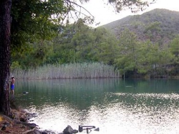
Büyük Cati is totally land locked cove, surrounded by pine trees, and it is very calm although the water is kind of murky. It is a lovely place almost unreal. Anchor in 4 m, good holding. It is best to take a stern line to a tree. | Büyük Cati is totally land locked cove, surrounded by pine trees, and it is very calm although the water is kind of murky. It is a lovely place almost unreal. Anchor in 4 m, good holding. It is best to take a stern line to a tree. | ||
| Line 120: | Line 113: | ||
* | * | ||
| - | <div style="clear: both;"> | + | <div style="clear: both;">[[Image:Hisaronu_Boyuk.jpg|350px|thumb|center|Büyük Cati<br />''Click for larger view'']]</div> |
| - | [[Image:Hisaronu_Boyuk.jpg| | + | |
| - | </div> | + | |
====Bekar Liman==== | ====Bekar Liman==== | ||
| - | [[Image:Hisaronu_Bekar.jpg|250px|thumb|right|Bekar Liman<br/>''Click for larger view'']] | + | [[Image:Hisaronu_Bekar.jpg|250px|thumb|right|Bekar Liman<br />''Click for larger view'']] |
| - | + | [[image:World_icon.png]] {{Coord|36|51.5|N|28|01.8|E|}}<br /> | |
| - | + | ||
Bekar Liman is a small cove in the 7-islands region. The entrance to the cove is only 2.7 m deep but inside the cove it is deeper, about 3.5 m. The holding is good but you must take a stern line to a tree. | Bekar Liman is a small cove in the 7-islands region. The entrance to the cove is only 2.7 m deep but inside the cove it is deeper, about 3.5 m. The holding is good but you must take a stern line to a tree. | ||
| Line 140: | Line 130: | ||
====Repairs/Yards==== | ====Repairs/Yards==== | ||
| - | [[Marti Marina]] operates a travel-lift and there at least two different repair shops. | + | [[Marti Marina]] operates a travel-lift and there are at least two different repair shops. |
====Fuel, Water, & Electricity==== | ====Fuel, Water, & Electricity==== | ||
| Line 151: | Line 141: | ||
==Tourism and Things to do Ashore== | ==Tourism and Things to do Ashore== | ||
| - | ===Tourism=== | + | ====Tourism==== |
[[Marti Marina]] is only 20 minutes by car from [[Marmaris]]. Also, near by there is a stable where one can go horseback ridding. | [[Marti Marina]] is only 20 minutes by car from [[Marmaris]]. Also, near by there is a stable where one can go horseback ridding. | ||
| - | ===Grocery Stores=== | + | ====Grocery Stores==== |
Most provisions can be purchased in the [[Marti Marina]] store. | Most provisions can be purchased in the [[Marti Marina]] store. | ||
| - | ===Eateries=== | + | ====Eateries==== |
Good food at ''Zuhal's'' and ''Sarunya'' restaurant. | Good food at ''Zuhal's'' and ''Sarunya'' restaurant. | ||
| - | ===Internet/WiFi=== | + | ====Internet/WiFi==== |
In [[Marti Marina]]. | In [[Marti Marina]]. | ||
| - | ===Laundry=== | + | ====Laundry==== |
In [[Marti Marina]]. | In [[Marti Marina]]. | ||
| - | ===Motorbike & Car Rentals=== | + | ====Motorbike & Car Rentals==== |
Can be arranged from [[Marti Marina]]. | Can be arranged from [[Marti Marina]]. | ||
| - | ===Garbage Disposal=== | + | ====Garbage Disposal==== |
There are bins around [[Marti Marina]] and in restaurants. | There are bins around [[Marti Marina]] and in restaurants. | ||
| - | ===Transportation=== | + | ====Transportation==== |
Taxi to [[Marmaris]] can be arranged from [[Marti Marina]]. | Taxi to [[Marmaris]] can be arranged from [[Marti Marina]]. | ||
==Routes/Passages To/From== | ==Routes/Passages To/From== | ||
| - | See [[Aegean_Sea#Passages|Aegean]]. | + | ''See [[Aegean_Sea#Passages|Aegean]]''. |
==Cruiser's Friends== | ==Cruiser's Friends== | ||
| Line 186: | Line 176: | ||
==External Links== | ==External Links== | ||
| - | + | * [http://en.wikipedia.org/wiki/Doris_(Asia_Minor) Doris] | |
| - | * | + | |
* | * | ||
* | * | ||
==References & Publications== | ==References & Publications== | ||
| - | See [[Turkey#References_&_Publications|Turkey]] | + | ''See [[Turkey#References_&_Publications|Turkey]]''. |
| - | + | ||
| - | + | ||
| - | + | ||
==Personal Notes== | ==Personal Notes== | ||
Personal experiences? | Personal experiences? | ||
* | * | ||
| + | |||
| + | ====Last Visited & Details Checked (and updated here)==== | ||
| + | ''See individual ports in this page''. | ||
| + | |||
{{Guide2}} | {{Guide2}} | ||
| - | <br/> | + | <br /> |
{|id="mp-right" width="100%" cellpadding="2" cellspacing="1" style="vertical-align:top; background:#fff5ee; border:1px solid #fa8072;" | {|id="mp-right" width="100%" cellpadding="2" cellspacing="1" style="vertical-align:top; background:#fff5ee; border:1px solid #fa8072;" | ||
! <h2 id="mp-itn-h2" style="margin:0; background:#ffe4e1; font-size:120%; font-weight:bold; border:1px solid #fa8072; text-align:left; color:#000; padding:0.2em 0.4em;">[[image:SailorSmiley.gif]]Contributors to this page</h2> | ! <h2 id="mp-itn-h2" style="margin:0; background:#ffe4e1; font-size:120%; font-weight:bold; border:1px solid #fa8072; text-align:left; color:#000; padding:0.2em 0.4em;">[[image:SailorSmiley.gif]]Contributors to this page</h2> | ||
|- | |- | ||
|style="color:#000;"|<small> | |style="color:#000;"|<small> | ||
| - | '''Names''': | + | '''Names''': [[User:Istioploos|Istioploos]], [[User:atheneoflymington|Athene of Lymington]] |
</small> | </small> | ||
|} | |} | ||
| - | <br> | + | |
| + | <br /> | ||
{|id="mp-right" width="100%" cellpadding="2" cellspacing="1" style="vertical-align:top; background:#f5faff; border:1px solid #a3b0bf;" | {|id="mp-right" width="100%" cellpadding="2" cellspacing="1" style="vertical-align:top; background:#f5faff; border:1px solid #a3b0bf;" | ||
! <h2 id="mp-itn-h2" style="margin:0; background:#cedff2; font-size:120%; font-weight:bold; border:1px solid #a3b0bf; text-align:left; color:#000; padding:0.2em 0.4em;">Cruising Wiki Navigation</h2> | ! <h2 id="mp-itn-h2" style="margin:0; background:#cedff2; font-size:120%; font-weight:bold; border:1px solid #a3b0bf; text-align:left; color:#000; padding:0.2em 0.4em;">Cruising Wiki Navigation</h2> | ||
| Line 219: | Line 210: | ||
|} | |} | ||
| - | [[Category: | + | |
| + | [[Category:Regions - Turkey]] [[Category:Anchorages - Turkey]] | ||
Revision as of 21:52, 7 January 2012
Hisarönü Körfesi to Teke Burnu
This deep gulf is also known as the Gulf of Doris or the Gulf of Symi. It is very indented and has many lovely anchorages, yet it is not too crowded.
Charts
- BA
- 1055 Rhodes Channel and Gökova Körfezi
- Imray-Tetra
- G35 Dodecanese and Coast of Turkey
- NIMA
- 54400 Samos to Rodhos
- Turkey
- 311 Bodrum Boğazı - Marmaris
- 3113 Hisarönü Körfezi - Yeşilova Körfezi
- Greek
- 451 Leros to Rhodos
Radio Nets
Also see Cruiser's Nets.
Submit details of local radio Nets.
Local Weather
See Turkey.
In general, the approach into the gulf and its anchorages is easy and presents no dangers.
Check-in facilities
The closest port of entry is Datça.
Ports and Popular Stops
There are no ports in the gulf other then Marti Marina, but there are many lovely anchorages.
Marinas & Yacht Clubs
Anchorages
Dirsek
![]() 36°41.6′N, 27°58.8′E - Chartlet
36°41.6′N, 27°58.8′E - Chartlet
Dirsek is not a very attractive cove.
Last Visited & Details Checked (and updated here)
Date of member's visit to this Port/Stop & this page's details validated:
- August 2002 --Istioploos

Selemiye Koyu
![]() 36°43.1′N, 28°06.3′E
36°43.1′N, 28°06.3′E
Selemiye Koyu is also known as Port Losta. There are several restaurants in this attractive cove that provide free docking (layed moorings) with water and electricity. The most popular and upscale is Sarunya (![]() 36°42.5′N, 28°05.3′E).
36°42.5′N, 28°05.3′E).
Last Visited & Details Checked (and updated here)
Date of member's visit to this Port/Stop & this page's details validated:
- August 2002 --Istioploos

Cove E of Delikliyol
![]() 36°43.6′N, 28°05.4′E - Chartlet
36°43.6′N, 28°05.4′E - Chartlet
This is a delightful isolated cove just E of Delikliyol Limani. Anchor in 7 m over sand.
Last Visited & Details Checked (and updated here)
Date of member's visit to this Port/Stop & this page's details validated:
- August 2002 --Istioploos

Keçi Bükü
![]() 36°46.2′N, 28°07.3′E
36°46.2′N, 28°07.3′E
This lovely bay is dominated by the large Marti Marina. Call ahead on channel 73. You will be met by a Joker boat at the entrance of the marina and shown to berth. The marina provides all the services.
In addition to Marti Marina you can moor for free (provided you eat there) at the dock of Zuhal's Restaurant (just 1 M N of Marti) and at Kadirs Restaurant at the SW tip of the bay. There are also three other restaurants at the southern end of the inlet, all with jetties, laid moorings, water and electricity and even (in some cases) free wifi.
Also you can anchor behind the little island with the Byzantine fort.
Danger: Watch out for the very shallow region on the SE end of the bay.
Last Visited & Details Checked (and updated here)
Date of member's visit to this Port/Stop & this page's details validated:
- August 2002 --Istioploos

- July 2007 --Atheneoflymington 14:43, 26 June 2009 (UTC)
Bencik Liman
![]() 36°46.9′N, 28°02.5′E
36°46.9′N, 28°02.5′E
There are many places to anchor in this deep heavily wooded bay. You will have to anchor fairly deeply in 6-10 m. The holding is good on mud and weed, but the water is murky so that you cannot see the bottom. Take a line to a tree to minimize swinging and interfering with other boats.
At the N end of the bay there is a river which leads to a fancy combining/hotel while in the E side there is another private summer resort known as the "Solar Research Station." Sharks have been reported but I have not seen one.
Warning: Care must be taken entering the bay because of reefs and shallow areas. Study your chart carefully.
Last Visited & Details Checked (and updated here)
Date of member's visit to this Port/Stop & this page's details validated:
- September 2002 --Istioploos

Büyük Cati
![]() 36°47.5′N, 28°0.9′E
36°47.5′N, 28°0.9′E
Büyük Cati is totally land locked cove, surrounded by pine trees, and it is very calm although the water is kind of murky. It is a lovely place almost unreal. Anchor in 4 m, good holding. It is best to take a stern line to a tree.
To the E of Büyük Cati there is a smaller cove, Kuçuk Cati, also very nice.
Last Visited & Details Checked (and updated here)
Date of member's visit to this Port/Stop & this page's details validated:
- August 2004 --Istioploos

Bekar Liman
![]() 36°51.5′N, 28°01.8′E
36°51.5′N, 28°01.8′E
Bekar Liman is a small cove in the 7-islands region. The entrance to the cove is only 2.7 m deep but inside the cove it is deeper, about 3.5 m. The holding is good but you must take a stern line to a tree.
Last Visited & Details Checked (and updated here)
Date of member's visit to this Port/Stop & this page's details validated:
- August 2004 --Istioploos

Yacht Repairs and Services
Marine Stores
In Marti Marina.
Repairs/Yards
Marti Marina operates a travel-lift and there are at least two different repair shops.
Fuel, Water, & Electricity
- Fuel
- Only in only in Marti Marina
- Water
- In Marti Marina and in most restaurant docks
- Electricity
- In Marti Marina and in most restaurant docks
Tourism and Things to do Ashore
Tourism
Marti Marina is only 20 minutes by car from Marmaris. Also, near by there is a stable where one can go horseback ridding.
Grocery Stores
Most provisions can be purchased in the Marti Marina store.
Eateries
Good food at Zuhal's and Sarunya restaurant.
Internet/WiFi
In Marti Marina.
Laundry
In Marti Marina.
Motorbike & Car Rentals
Can be arranged from Marti Marina.
Garbage Disposal
There are bins around Marti Marina and in restaurants.
Transportation
Taxi to Marmaris can be arranged from Marti Marina.
Routes/Passages To/From
See Aegean.
Cruiser's Friends
Contact details of "Cruiser's Friends" that can be contacted for local information or assistance.
Forum Discussions
List links to discussion threads on partnering forums. (see link for requirements)
External Links
References & Publications
See Turkey.
Personal Notes
Personal experiences?
Last Visited & Details Checked (and updated here)
See individual ports in this page.
|
|---|
|
Names: Istioploos, Athene of Lymington |
| |
|---|
| | HOMEPAGE | Wiki Contents | Mediterranean | Aegean Sea | Turkey | Hisaronu Korfezi to Teke Burnu | |
