Hook Island
From CruisersWiki
m (Text replace - "|} '''Cruising the region''' " to "|} {{TOCleft}} ====Cruising the region==== ") |
m (Text replace - "===Anchorages===" to "==Anchorages==") |
||
| (40 intermediate revisions not shown) | |||
| Line 1: | Line 1: | ||
| - | + | {{IsPartOf|Queensland|Whitsundays}} | |
| - | + | {{TOC block}} | |
| - | + | ||
| - | ==== | + | {{Infobox |
| + | | lat= -20.116667 | ||
| + | | lon= 148.916667 | ||
| + | | zoom= 11 | ||
| + | | chartlet= y | ||
| + | | image=Australia HookIslandS.jpg | ||
| + | | imagetext= Satellite view of Hook Island | ||
| + | | notes= | ||
| + | | news= | ||
| + | }} | ||
| - | + | [http://en.wikipedia.org/wiki/Hook_Island Hook Island] is one of the [[Whitsundays|Whitsunday Islands]] off the coast of the Australian state of [[Queensland]]. The island is almost uninhabited, quite rugged and almost completely contained within a section of the [http://en.wikipedia.org/wiki/Whitsunday_Islands_National_Park Whitsunday Islands National Park]. The island has two prominent geographical features on the southern side of Hook Island; the Nara and Macona inlets, two fjord-like recesses that are popular anchorages. The island's northern coast is noted for its colourful underwater coral growths, to which snorkelling and diving enthusiasts are attracted. | |
| - | + | Some of the oldest archaeological sites ever found in Eastern Australia are the caves and midden of the Ngaro People on Hook Island. A site at Nara Inlet is the oldest indication of [http://www.abc.net.au/local/stories/2008/06/25/2285036.htm Aboriginal occupation in the Great Barrier Reef Marine Park]. | |
| - | + | ||
| - | + | ||
| - | + | ||
| - | + | ||
| - | + | ||
| - | + | ||
| - | + | ||
| - | + | ||
| - | + | ||
| - | + | ||
| - | + | ||
| - | + | ||
| - | + | ||
| - | + | ||
| - | + | ||
| - | + | ||
==Charts== | ==Charts== | ||
| - | + | ''See [[Whitsundays#Charts|Whitsundays]]''. | |
| - | + | ||
| - | + | ||
| - | + | ||
| - | + | ||
| - | '' | + | |
| - | + | ||
==Weather== | ==Weather== | ||
| - | + | ''See [[Queensland#Weather|Queensland]]''. | |
| - | + | ==Passages== | |
| - | + | ''See [[Whitsundays#Passages|Whitsundays]]''. | |
| - | == | + | ==Islands== |
| - | + | ''See [[Whitsundays#Islands|Whitsundays]]''. | |
| - | == | + | ==Communication== |
| - | + | ''See [[Whitsundays#Communication|Whitsundays]]''. | |
| - | == | + | ==Navigation== |
| + | ''See individual [[#Anchorages|anchorages]]''. | ||
| + | |||
| + | ==Berthing== | ||
===Ports=== | ===Ports=== | ||
| - | + | None. | |
| - | === | + | ===Marinas & Yacht Clubs=== |
| - | + | None. | |
| - | + | ||
| - | == | + | ==Anchorages== |
| - | + | There are many anchorages around the island. The southern anchorages are well protected from the prevailing southern winds while the northern anchorages afford spectacular snorkeling. | |
| - | + | ||
| - | == | + | {{Poi |20|7.9|S|148|54.8|E | type= anchorage | name= Nara Inlet | zoom= 13 |
| - | + | | image=Australia_HookIsland_Nara.jpg| | |
| - | == | + | | imagetext= Nara Bay from the NE |
| - | + | | imagewidth= | |
| - | + | | text= {{Caution}}Follow the buoys when entering the bay. | |
| + | Anchor on the E side in 5-6 m depth allowing enough scope to accommodate the more then 2 m tide. Good holding. Avoid the small cove on the W side which is surrounded with reefs and shallows. | ||
| - | + | You can visit the [http://en.wikipedia.org/wiki/Ngaro_people Ngaro] cave on the [[#Tourism|NE side]] of the bay.}} | |
| - | + | {{hold vertical}} | |
| - | ==== | + | {{Poi | lat=-20.0706 |lon=148.92946 | type= anchorage | name= Butterfly Bay | zoom= 14 |
| - | + | | image= Australia_HookIsland_Mooring.jpg | |
| - | + | | imagetext= Mooring in Butterfly Bay | |
| - | + | | imagewidth= | |
| - | : | + | | text= Butterfly Bay, on the N side of the island, actually consists of two coves: a large on the W and a smaller on on the E. |
| - | + | ||
| - | + | ||
| - | + | Anchorage is restricted on both coves but there are many [http://en.wikipedia.org/wiki/Whitsunday_Islands_National_Park Whitsunday Islands National Park] moorings. Use of these moorings is restricted to 2 hours but if you are in possession of one by 4 PM you can stay moored overnight. | |
| - | + | ||
| - | + | ||
| - | + | Anchoring outside the restricted area can be problematic as the depths exceed 12 m. }} | |
| - | + | {{hold vertical}} | |
| - | + | ||
| - | + | ||
| - | === | + | {{Poi |20|4.0|S|148|56.4|E| type= anchorage | name= Maureen's Bay | zoom= 14 |
| - | + | | image= Australia_HookIsland_Maureen.jpg | |
| + | | imagetext= Maureen's Bay | ||
| + | | imagewidth= | ||
| + | | text= Maureen's Bay, just E of Butterfly Bay, is a very attractive and relative well sheltered cove, exposed to the N. | ||
| - | + | Once again anchorage is restricted but there are about 4 [http://en.wikipedia.org/wiki/Whitsunday_Islands_National_Park Whitsunday Islands National Park] moorings. Use of these moorings is restricted to 2 hours but if you are in possession of one by 4 PM you can stay moored overnight. | |
| - | + | ||
| - | + | Anchoring outside the restricted area can be problematic as the depths exceed 14 m. | |
| - | + | ||
| - | + | The snorkeling here is excellent. }} | |
| - | + | {{hold vertical}} | |
| - | === | + | {{Poi |lat=-20.06174 |lon=148.94972 | type= anchorage | name= Launcheon Bay | zoom= 14 |
| - | + | | image= Australia_HookIsland_Luncheon.jpg | |
| + | | imagetext= Launcheon Bay | ||
| + | | imagewidth= | ||
| + | | portofentry= | ||
| + | | text= Launcheon Bay is a further E of [[#Maureen's_Bay|Maureen's Bay]] but it is rather exposed to the N and may not be the most secure place to overnight. Nevertheless it has the most spectacular underwater on the island. | ||
| - | + | Once again anchorage is restricted but there are about 3 [http://en.wikipedia.org/wiki/Whitsunday_Islands_National_Park Whitsunday Islands National Park] moorings. Use of these moorings is restricted to 2 hours but if you are in possession of one by 4 PM you can stay moored overnight (not recommended). | |
| - | + | ||
| - | + | Anchoring here can be problematic as the depths exceed 16 m. }} | |
| - | + | {{hold vertical}} | |
| - | + | ||
| - | == | + | {{Poi |20|9.3|S|148|55.7|E| | type= anchorage | name= Macona Inlet | zoom= 13 |
| - | + | | image= Australia_HookIsland_Macona.jpg | |
| - | + | | imagetext= Macona Inlet from the S | |
| + | | imagewidth= | ||
| + | | portofentry= | ||
| + | | text= Macona Inlet is a nice and secure anchorage on the south of the island and E of [[#Nara_Inlet|Nara Inlet]]. Anchor anywhere convenient at 4-6 m depth. Good holding. Allow enough scope to accommodate the more then 2 m tide. | ||
| - | == | + | {{Caution}}Follow the buoys when entering the inlet.}} |
| + | |||
| + | ==Amenities== | ||
| + | N/A (Not Available). | ||
| + | |||
| + | ==Provisioning== | ||
| + | N/A. | ||
| + | |||
| + | ==Eating out== | ||
| + | N/A. | ||
| + | |||
| + | ==Transportation== | ||
| + | N/A. | ||
| + | |||
| + | ==Tourism== | ||
| + | {| class="wikitable" align=right | ||
| + | |- | ||
| + | |[[Image:Australia_HookIsland_Nara2.jpg|300px]]<br /><small>Ngaro Cave Paintings </small> | ||
| + | |- | ||
| + | |[[Image:Australia_HookIsland_Maureen2.jpg|300px]]<br /><small>Underwater in Maureen's Bay </small> | ||
| + | |- | ||
| + | |[[Image:Australia_HookIsland_Luncheon2.jpg|300px]]<br /><small>Corals in Luncheon Bay </small> | ||
| + | |- | ||
| + | |[[Image:Australia_HookIsland_Luncheon3.jpg|300px]]<br /><small>[http://en.wikipedia.org/wiki/Stingray Stingray] in Luncheon Bay </small> | ||
| + | |} | ||
| + | Visit the [http://en.wikipedia.org/wiki/Ngaro_people Ngaro] cave on the NE side of [[#Nara_Inlet|Nara Inlet]]. A nice wooden footpath leads to the cave which has some [http://en.wikipedia.org/wiki/Australian_Aborigine aboriginal] paintings. | ||
| + | |||
| + | The view of the inlet from up the hill is very nice and the hike to the cave is one of a few hikes possible in the Whitsunday islands because of the very thick vegetation. | ||
| + | |||
| + | The snorkeling in [[#Maureen's_Bay|Maureen's Bay]] is wonderful and in [[#Launcheon_Bay|Launcheon Bay]] spectacular. | ||
| + | |||
| + | ==Friends== | ||
Contact details of "Cruiser's Friends" that can be contacted for local information or assistance. | Contact details of "Cruiser's Friends" that can be contacted for local information or assistance. | ||
* | * | ||
| - | == | + | ==Forums== |
| - | List links to discussion threads on [[Cruising Forums|partnering forums]]. (see link for requirements) | + | List links to discussion threads on [[Cruising Forums|partnering forums]]. (''see link for requirements'') |
* | * | ||
| - | == | + | ==Links== |
| - | + | * {{wikipedia}} | |
| - | * | + | * {{Wikivoyage|Hook_island}} |
| + | * [http://en.wikipedia.org/wiki/Whitsunday_Islands_National_Park Whitsunday Islands National Park] | ||
| - | ==References | + | ==References== |
| - | + | ''See [[Whitsundays#References_&_Publications|Whitsundays]]''. | |
| - | + | ||
| - | + | {{Comments}} | |
| - | + | * Have cruised in the island. --[[User:Istioploos|Istioploos]] [[Image:Greece_Icon.png]] [[File:Sailboat_favicon.png]] [http://www.sy-thetis.org Travels with S/Y Thetis] | |
| - | * | + | |
| - | + | {{Verified by}} | |
| - | + | * April 2011 --[[User:Istioploos|Istioploos]] | |
| - | + | {{hold vertical}} | |
| - | {{ | + | {{page useable}} |
| + | {{Contributors|[[User:Istioploos|Istioploos]]}} | ||
| - | + | [[Category:Islands - Australia]] [[Category:Islands - Whitsundays]] | |
| - | + | ||
| - | + | ||
| - | + | ||
| - | + | ||
| - | + | ||
| - | + | ||
| - | + | ||
| - | + | ||
| - | + | ||
| - | + | ||
| - | + | ||
| - | + | ||
| - | + | ||
| - | + | ||
| - | [[Category:Islands - | + | |
Latest revision as of 07:47, 16 August 2018
| Hook Island
| |
| | |
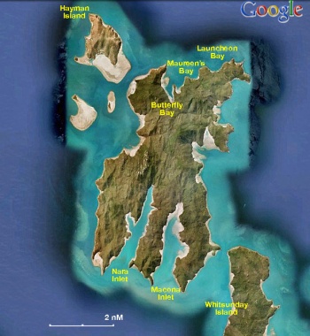
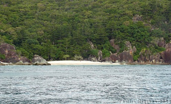
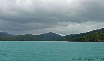
Hook Island is one of the Whitsunday Islands off the coast of the Australian state of Queensland. The island is almost uninhabited, quite rugged and almost completely contained within a section of the Whitsunday Islands National Park. The island has two prominent geographical features on the southern side of Hook Island; the Nara and Macona inlets, two fjord-like recesses that are popular anchorages. The island's northern coast is noted for its colourful underwater coral growths, to which snorkelling and diving enthusiasts are attracted.
Some of the oldest archaeological sites ever found in Eastern Australia are the caves and midden of the Ngaro People on Hook Island. A site at Nara Inlet is the oldest indication of Aboriginal occupation in the Great Barrier Reef Marine Park.
Charts
See Whitsundays.
Weather
See Queensland.
Passages
See Whitsundays.
Islands
See Whitsundays.
Communication
See Whitsundays.
See individual anchorages.
Berthing
Ports
None.
Marinas & Yacht Clubs
None.
Anchorages
There are many anchorages around the island. The southern anchorages are well protected from the prevailing southern winds while the northern anchorages afford spectacular snorkeling.
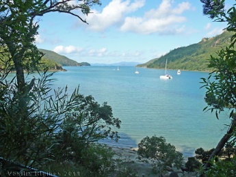
Nara Inlet
Butterfly Bay
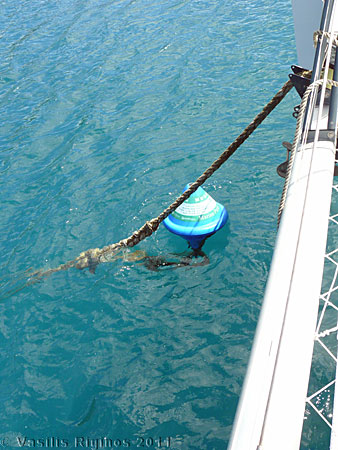
Butterfly Bay, on the N side of the island, actually consists of two coves: a large on the W and a smaller on on the E.
Anchorage is restricted on both coves but there are many Whitsunday Islands National Park moorings. Use of these moorings is restricted to 2 hours but if you are in possession of one by 4 PM you can stay moored overnight.
Anchoring outside the restricted area can be problematic as the depths exceed 12 m.Maureen's Bay
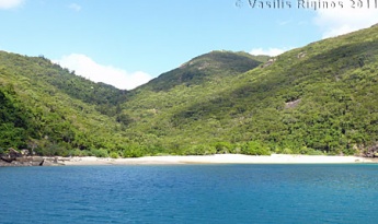
Maureen's Bay, just E of Butterfly Bay, is a very attractive and relative well sheltered cove, exposed to the N.
Once again anchorage is restricted but there are about 4 Whitsunday Islands National Park moorings. Use of these moorings is restricted to 2 hours but if you are in possession of one by 4 PM you can stay moored overnight.
Anchoring outside the restricted area can be problematic as the depths exceed 14 m.
The snorkeling here is excellent.Launcheon Bay
Launcheon Bay is a further E of Maureen's Bay but it is rather exposed to the N and may not be the most secure place to overnight. Nevertheless it has the most spectacular underwater on the island.
Once again anchorage is restricted but there are about 3 Whitsunday Islands National Park moorings. Use of these moorings is restricted to 2 hours but if you are in possession of one by 4 PM you can stay moored overnight (not recommended).
Anchoring here can be problematic as the depths exceed 16 m.Macona Inlet
Macona Inlet is a nice and secure anchorage on the south of the island and E of Nara Inlet. Anchor anywhere convenient at 4-6 m depth. Good holding. Allow enough scope to accommodate the more then 2 m tide.
Caution: Follow the buoys when entering the inlet.Amenities
N/A (Not Available).
Provisioning
N/A.
Eating out
N/A.
Transportation
N/A.
Tourism
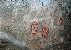 Ngaro Cave Paintings |
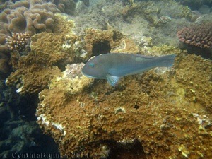 Underwater in Maureen's Bay |
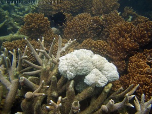 Corals in Luncheon Bay |
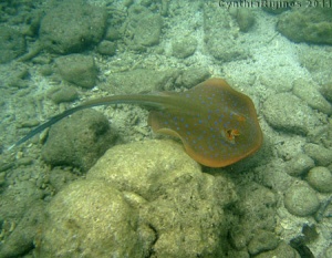 Stingray in Luncheon Bay |
Visit the Ngaro cave on the NE side of Nara Inlet. A nice wooden footpath leads to the cave which has some aboriginal paintings.
The view of the inlet from up the hill is very nice and the hike to the cave is one of a few hikes possible in the Whitsunday islands because of the very thick vegetation.
The snorkeling in Maureen's Bay is wonderful and in Launcheon Bay spectacular.
Friends
Contact details of "Cruiser's Friends" that can be contacted for local information or assistance.
Forums
List links to discussion threads on partnering forums. (see link for requirements)
Links
- Hook Island at the Wikipedia
- Hook Island at the Wikivoyage
- Whitsunday Islands National Park
References
See Whitsundays.
Comments
We welcome users' contributions to the Wiki. Please click on Comments to view other users' comments, add your own personal experiences or recommend any changes to this page following your visit.
- Have cruised in the island. --Istioploos

 Travels with S/Y Thetis
Verified by
Date of member's last visit to Hook Island and this page's details validated:
- April 2011 --Istioploos
| This is a usable page of the cruising guide. However, please contribute if you can to help it grow further. Click on Comments to add your personal notes on this page or to discuss its contents. Alternatively, if you feel confident to edit the page, click on the edit tab at the top and enter your changes directly. |
| |
|---|
|
Names: Istioploos |
