Juan de Nova
From CruisersWiki
Lighthouse (Talk | contribs) m (Text replace - "Indian Ocean" to "Indian Ocean Cruising Guide") |
Istioploos (Talk | contribs) (Updated) |
||
| (36 intermediate revisions not shown) | |||
| Line 1: | Line 1: | ||
| - | + | {{IsPartOf|Africa|East Africa|Mozambique|Madagascar|Mozambique Channel}} | |
| - | + | {{TOC block}} | |
| - | + | ||
| - | === | + | {{Infobox | lat=-17.05633 | lon=42.7265 |
| - | Juan de Nova Island (also ''Saint-Christophe'', French: locally ''Île Juan de Nova'' or officially ''Île Juan da Nova'') is a 4.4 km² low, flat, tropical island in the narrowest part of the Mozambique Channel, about one-third of the way between Madagascar and Mozambique. Anchorage is possible off the northeast of the island which also has a 1,300-metre-long airstrip. | + | | name= Juan de Nova |
| + | | zoom= 13 | ||
| + | | chartlet= y | ||
| + | | image= Juan_de_Nova_map.gif | ||
| + | | imagetext= Juan de Nova, Mozambique Channel | ||
| + | | summary= '''Juan de Nova Island''' (also ''Saint-Christophe'', French: locally ''Île Juan de Nova'' or officially ''Île Juan da Nova'') is a 4.4 km² low, flat, tropical island in the narrowest part of the Mozambique Channel, about one-third of the way between [[Madagascar]] and [[Mozambique]]. Anchorage is possible off the northeast of the island which also has a 1,300-metre-long airstrip. | ||
| - | Administratively, the island is one of the Scattered islands in the [[Indian Ocean | + | Administratively, the island is one of the Scattered islands in the [[Indian Ocean]], a district of the French Southern and Antarctic Lands. |
| - | Juan de Nova, about six kilometres long and 1. | + | Juan de Nova, about six kilometres long and 1.6 km at its widest, is a nature reserve surrounded by reefs which enclose an area (not a true lagoon like in an atoll) of roughly 40 km². Forests, mainly of Casuarinaceae, cover about half the island. Large numbers of terns (''Sterna fuscata'') breed there from November to March. Turtles nest in the beaches around the island. |
The island is named after João da Nova, a Galician admiral in the service of [[Portugal]] who came across the island in 1501. It has been a French possession since 1897. Guano (phosphate) deposits were exploited from the start of the 20th century until 1970. The island was abandoned during World War II and was visited by German submariners. Installations, including a hangar, rail lines, houses and a jetty are in ruins. | The island is named after João da Nova, a Galician admiral in the service of [[Portugal]] who came across the island in 1501. It has been a French possession since 1897. Guano (phosphate) deposits were exploited from the start of the 20th century until 1970. The island was abandoned during World War II and was visited by German submariners. Installations, including a hangar, rail lines, houses and a jetty are in ruins. | ||
| - | Juan de Nova, with an Exclusive Economic Zone (EEZ) of 61,050 km², is claimed by [[Madagascar]]. The island is garrisoned by French troops from | + | Juan de Nova, with an Exclusive Economic Zone (EEZ) of 61,050 km², is claimed by [[Madagascar]]. The island is garrisoned by French troops from [[Reunion]] and has a meteorological station (Saint-Christophe). |
| - | Juan de Nova, in the sea route between [[South Africa]] and the northern tip of [[Madagascar]], is affected by strong currents | + | Juan de Nova, in the sea route between [[South Africa]], and the northern tip of [[Madagascar]], is affected by strong currents and has become the site of numerous wrecks. Most visible are the remains of the SS Tottenham which ran onto the southern fringing reef in 1911. |
| + | | notes= | ||
| + | | news= | ||
| + | }} | ||
| + | |||
| + | |||
| + | ==Charts== | ||
| + | ; British Admiralty | ||
| + | : BA3868 – Cap Kimby to Cap Saint André | ||
| + | : BA2461 – Plans od the north and west Coasts of Madagascar | ||
| + | : BA1810 – Mozambique Channel | ||
| - | |||
| - | |||
| - | |||
* | * | ||
| - | == | + | ==Weather== |
| - | + | {{GreenText|Give local weather conditions or refer to another page (a region or island group) that covers these conditions.}} | |
| + | |||
| + | Sources for Weather forecasts: | ||
| + | * | ||
* | * | ||
| - | == | + | ==Passages== |
| - | + | * [[Mozambique Channel]] | |
| + | * | ||
| - | + | ==Communication== | |
| + | {{Green|Add here VHF channel for coastguard, harbor masters. etc.}} | ||
* | * | ||
| + | * | ||
| - | |||
| - | |||
| - | |||
| - | |||
| - | |||
| - | + | ''Also see [[HF_Radio|Cruiser's Nets]]'' | |
| - | + | ||
| - | == | + | ==Navigation== |
| - | + | {{GreenText|Any navigation notes here. If this section does not apply remove it.}} | |
| - | + | ||
| - | + | ||
| - | + | ||
| - | == | + | ==Entrance== |
| - | + | {{GreenText|If there is '''no''' ''port of entry'' in the island '''omit''' this section, otherwise submit details about facilities for checking in - where to dock, location of immigration & customs, etc.}} | |
| - | + | ||
| - | == | + | ==Berthing== |
| - | + | There is only an achorage. | |
| - | === | + | ===Ports=== |
| - | + | None. | |
| - | === | + | ===Marinas & Yacht Clubs=== |
| - | + | None. | |
| + | |||
| + | ==Anchorages== | ||
| + | {{poi | lat= -17.02917|lon=42.73234 | ||
| + | | type= anchorage | ||
| + | | name=NE Anchorage | ||
| + | | altname= | ||
| + | | url= | ||
| + | | zoom= 13 | ||
| + | | image= | ||
| + | | imagetext= | ||
| + | | text= | ||
| + | }} | ||
| + | {{hgallery| | ||
| + | {{himage|Juan_de_Nova_1.jpg |Juan de Nova}} | ||
| + | {{himage|Juan_de_Nova_2.jpg |Juan de Nova}} | ||
| + | {{himage|Juan_de_Nova_3.jpg |Juan de Nova}} | ||
| + | }} | ||
| + | |||
| + | |||
| + | ==Amenities== | ||
| + | N/A (Not Available). | ||
| + | |||
| + | ==Provisioning== | ||
| + | N/A. | ||
| + | |||
| + | ==Eating out== | ||
| + | N/A. | ||
| + | |||
| + | ==Transportation== | ||
| + | * There is a 1,300-m (4,300 ft) unpaved airstrip | ||
| + | * There is no public transportation to the island | ||
| + | |||
| + | ==Tourism== | ||
| + | The island is a bird sanctuary. | ||
| + | |||
| + | |||
| + | ==Friends== | ||
| + | Contact details of "Cruiser's Friends" that can be contacted for local information or assistance. | ||
* | * | ||
| + | |||
| + | ==Forums== | ||
| + | List links to discussion threads on [[Cruising Forums|partnering forums]]. (''see link for requirements'') | ||
* | * | ||
| - | == | + | ==Links== |
| - | + | * {{Wikipedia|Juan de Nova_Island}} | |
| - | + | * {{Wikivoyage|Juan de Nova Island}} | |
| - | * | + | |
* | * | ||
| - | == | + | ==References== |
| - | + | ''See [[Mozambique Channel#References|Mozambique Channel]]''. | |
| - | + | ||
| + | |||
| + | {{Comments}} | ||
* | * | ||
* | * | ||
| - | + | {{Verified by}} | |
| - | + | * | |
* | * | ||
| - | |||
| - | |||
| - | |||
| - | |||
| + | {{Green|If you provide a lot of info and this page is almost complete, change <nowiki>{{Page outline}} to {{Page useable}}</nowiki>.}} | ||
| - | {{ | + | {{Page outline}} |
| - | { | + | {{Contributors|[[User:Lighthouse|Lighthouse]]}} |
| - | + | ||
| - | + | ||
| - | + | ||
| - | + | ||
| - | + | [[Category:Islands - Madagascar]] [[Category:Islands - France]] [[Category:Anchorages - Madagascar]] | |
| - | + | ||
Latest revision as of 18:19, 17 May 2019
| Juan de Nova
| |
| | |
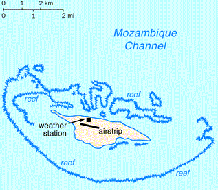
Juan de Nova Island (also Saint-Christophe, French: locally Île Juan de Nova or officially Île Juan da Nova) is a 4.4 km² low, flat, tropical island in the narrowest part of the Mozambique Channel, about one-third of the way between Madagascar and Mozambique. Anchorage is possible off the northeast of the island which also has a 1,300-metre-long airstrip.
Administratively, the island is one of the Scattered islands in the Indian Ocean, a district of the French Southern and Antarctic Lands.
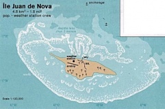
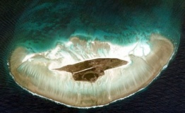
Juan de Nova, about six kilometres long and 1.6 km at its widest, is a nature reserve surrounded by reefs which enclose an area (not a true lagoon like in an atoll) of roughly 40 km². Forests, mainly of Casuarinaceae, cover about half the island. Large numbers of terns (Sterna fuscata) breed there from November to March. Turtles nest in the beaches around the island.
The island is named after João da Nova, a Galician admiral in the service of Portugal who came across the island in 1501. It has been a French possession since 1897. Guano (phosphate) deposits were exploited from the start of the 20th century until 1970. The island was abandoned during World War II and was visited by German submariners. Installations, including a hangar, rail lines, houses and a jetty are in ruins.
Juan de Nova, with an Exclusive Economic Zone (EEZ) of 61,050 km², is claimed by Madagascar. The island is garrisoned by French troops from Reunion and has a meteorological station (Saint-Christophe).
Juan de Nova, in the sea route between South Africa, and the northern tip of Madagascar, is affected by strong currents and has become the site of numerous wrecks. Most visible are the remains of the SS Tottenham which ran onto the southern fringing reef in 1911.
Charts
- British Admiralty
- BA3868 – Cap Kimby to Cap Saint André
- BA2461 – Plans od the north and west Coasts of Madagascar
- BA1810 – Mozambique Channel
Weather
Give local weather conditions or refer to another page (a region or island group) that covers these conditions.
Sources for Weather forecasts:
Passages
Communication
Add here VHF channel for coastguard, harbor masters. etc.
Also see Cruiser's Nets
Any navigation notes here. If this section does not apply remove it.
Entrance
If there is no port of entry in the island omit this section, otherwise submit details about facilities for checking in - where to dock, location of immigration & customs, etc.
Berthing
There is only an achorage.
Ports
None.
Marinas & Yacht Clubs
None.
Anchorages
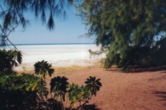
NE Anchorage
Amenities
N/A (Not Available).
Provisioning
N/A.
Eating out
N/A.
Transportation
- There is a 1,300-m (4,300 ft) unpaved airstrip
- There is no public transportation to the island
Tourism
The island is a bird sanctuary.
Friends
Contact details of "Cruiser's Friends" that can be contacted for local information or assistance.
Forums
List links to discussion threads on partnering forums. (see link for requirements)
Links
- Juan de Nova at the Wikipedia
- Juan de Nova at the Wikivoyage
References
See Mozambique Channel.
Comments
We welcome users' contributions to the Wiki. Please click on Comments to view other users' comments, add your own personal experiences or recommend any changes to this page following your visit.
Verified by
Date of member's last visit to Juan de Nova and this page's details validated:
If you provide a lot of info and this page is almost complete, change {{Page outline}} to {{Page useable}}.
| This page has an outline in place but needs completing. Please contribute if you can to help it grow further. Click on Comments to suggest further content or alternatively, if you feel confident to edit this page, click on the edit tab at the top and enter your changes directly. |
| |
|---|
|
Names: Lighthouse |


