Juan de Nova
From CruisersWiki
Contents
|
Juan de Nova Island, Mozambique Channel
Background
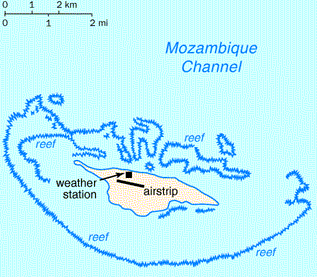
Juan de Nova Island (also Saint-Christophe, French: locally Île Juan de Nova or officially Île Juan da Nova) is a 4.4 km² low, flat, tropical island in the narrowest part of the Mozambique Channel, about one-third of the way between Madagascar and Mozambique. Anchorage is possible off the northeast of the island which also has a 1,300-metre-long airstrip.
Administratively, the island is one of the Scattered islands in the Indian Ocean, a district of the French Southern and Antarctic Lands.
Juan de Nova, about six kilometres long and 1.6km at its widest, is a nature reserve surrounded by reefs which enclose an area (not a true lagoon like in an atoll) of roughly 40 km². Forests, mainly of Casuarinaceae, cover about half the island. Large numbers of terns (Sterna fuscata) breed there from November to March. Turtles nest in the beaches around the island.
The island is named after João da Nova, a Galician admiral in the service of Portugal who came across the island in 1501. It has been a French possession since 1897. Guano (phosphate) deposits were exploited from the start of the 20th century until 1970. The island was abandoned during World War II and was visited by German submariners. Installations, including a hangar, rail lines, houses and a jetty are in ruins.
Juan de Nova, with an Exclusive Economic Zone (EEZ) of 61,050 km², is claimed by Madagascar. The island is garrisoned by French troops from Réunion and has a meteorological station (Saint-Christophe).
Juan de Nova, in the sea route between South Africa and the northern tip of Madagascar, is affected by strong currents, and has become the site of numerous wrecks. Most visible are the remains of the SS Tottenham which ran onto the southern fringing reef in 1911.
Charts
- 3868
- 2461
Radio Nets
Also see Cruiser's Nets
Weather
Local weather conditions?
Sources for Weather forecasts:
Details?
Anchorages
List details of all safe anchorages in the area.
Things to do
Fuel, Water, & Electricity
Routes/Passages To/From
Popular passages/routes, timing, etc.
References & Publications
- Islands and Atolls in the Mozambique Channel Cruising Notes by Tony Herrick.
Forum Discussions
List links to discussion threads on the Cruiser Log Forum
External Links
Links to relevant websites.
Personal Notes
Personal experiences?
Last Visited & Details Checked (and updated here)
Date of member's visit to this Port/Stop & this page's details validated:
| |
|---|
| | HOMEPAGE | Wiki Contents | Africa | East Africa | Mozambique | Madagascar | Mozambique Channel | Juan de Nova | |
.


