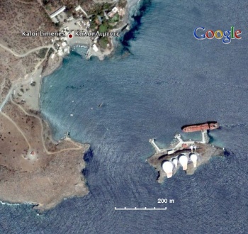
Kali Limenes
From CruisersWiki
Istioploos (Talk | contribs) m (→Kali Limenes: Help) |
Istioploos (Talk | contribs) (Coords & Edits) |
||
| Line 7: | Line 7: | ||
|} | |} | ||
| - | [[Image: | + | GPS: {{Coord|34|55.8|N|24|48.6|E|}} |
| + | [[Image:Greece_Crete_Kali_Limenes_S.jpg|350px|thumb|right|Satellite View of Kali Limenes - [http://mapserver.maptech.com/homepage/index.cfm?lat=34.930006668793915&lon=24.805118517705004&scale=15000&zoom=50&type=0&icon=0&width=498&height=498&searchscope=dom&CFID=1509264&CFTOKEN=22608242&scriptfile=http://mapserver.maptech.com/homepage/index.cfm&latlontype=DMS Chartlet]<br/>''Click for larger view'']] | ||
===Background=== | ===Background=== | ||
| - | Kali Limenes (Καλοί Λιμένες) | + | [http://www.infomarine.gr/greece/kalilimenes/ Kali Limenes] (Καλοί Λιμένες) is a large, very commercial, bunkering ship anchorage in southern Crete. |
===Charts=== | ===Charts=== | ||
| Line 93: | Line 94: | ||
===External Links=== | ===External Links=== | ||
| - | + | * [http://www.infomarine.gr/greece/kalilimenes/ Kali Limenes] Harbor Info | |
| - | * | + | |
* | * | ||
* | * | ||
| Line 114: | Line 114: | ||
! <h2 id="mp-itn-h2" style="margin:0; background:#cedff2; font-size:120%; font-weight:bold; border:1px solid #a3b0bf; text-align:left; color:#000; padding:0.2em 0.4em;">Cruising Wiki Navigation</h2> | ! <h2 id="mp-itn-h2" style="margin:0; background:#cedff2; font-size:120%; font-weight:bold; border:1px solid #a3b0bf; text-align:left; color:#000; padding:0.2em 0.4em;">Cruising Wiki Navigation</h2> | ||
|- | |- | ||
| - | |style="color:#000;"| | [[Cruising_and_Sailing_Wiki_by_CruiserLog|HOMEPAGE]] | [[Cruising|Wiki Contents]] | | [[Med|Mediterranean]] | [[Greece]] | [[Crete]] | [[Kali Limenes]] | | + | |style="color:#000;"| | [[Cruising_and_Sailing_Wiki_by_CruiserLog|HOMEPAGE]] | [[Cruising|Wiki Contents]] | | [[Med|Mediterranean]] | [[Aegean Sea]] | [[Greece]] | [[Crete]] | [[Kali Limenes]] | |
|} | |} | ||
. | . | ||
Revision as of 20:10, 19 February 2009
Kali Limenes
HELP! This section is lagging behind in development. |
|---|
| Your assistance is required to develop these pages into a useful resource. Bring out the hidden "cruising guide writer" in you and share your information here (in the true cruising spirit) for all who follow in your wake. |
GPS: 34°55.8′N, 24°48.6′E
Background
Kali Limenes (Καλοί Λιμένες) is a large, very commercial, bunkering ship anchorage in southern Crete.
Charts
See Crete
Radio Nets
See also Crete
- Coast Guard - VHF channel 12
- Port Authority - VHF channels 14, 16 & 69 tel. +30 892 42188
Details?
Check-in facilities
Submit details about facilities for checking in - where to dock, etc.
Anchorages
List details of all safe anchorages in the area.
Offshore Islands
List Islands
Tourism & things to do ashore
List places of interest, tours, etc.
Fuel, Water, & Electricity
Laundry
Grocery & Supply Stores
Eateries
Internet/WiFi
Available?
Motorbike & Car Rentals
Marine Stores & Facilities
Submit addresses and contact details of marine related businesses that are of interest to cruisers.
Repairs
Garbage Disposal
?
Transportation
Transportation (local and/or international)
Routes/Passages To/From
Popular passages/routes, timing, etc.
References & Publications
See Greece.
Cruiser's Friends
Contact details of "Cruiser's Friends" that can be contacted for local information or assistance.
Forum Discussions
List links to discussion threads on the Cruiser Log Forum
External Links
- Kali Limenes Harbor Info
Personal Notes
Personal experiences?
Last Visited & Details Checked (and updated here)
Date of member's visit to this Port/Stop & this page's details validated:
| |
|---|
| | HOMEPAGE | Wiki Contents | | Mediterranean | Aegean Sea | Greece | Crete | Kali Limenes | |
.
